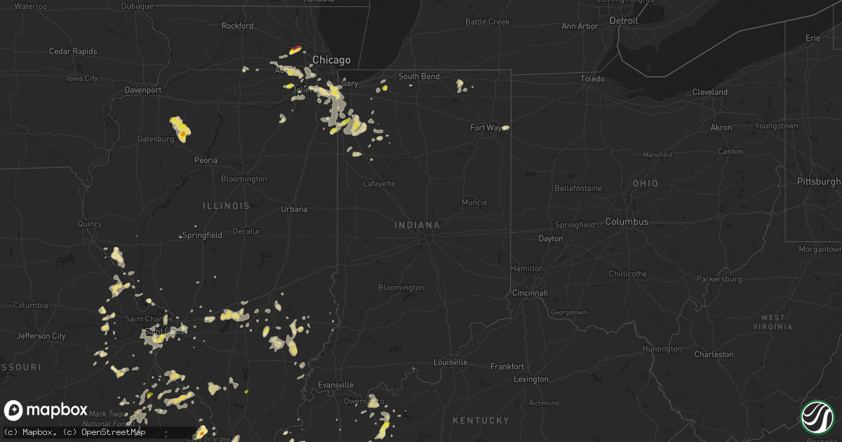
Hail Map in Indiana on June 26, 2019
Get this storm
June 26 map
$229
one time, instant access
Download today. No call, no setup
Keep the $229
Bought the map and want the full workflow? Apply the entire $229 to a subscription within 7 days. None of it is wasted.
Every map, not just this one
This buys you this map. Subscription and you get every map we run, in the markets you choose from a few cities to whole states to nationwide. Plus real-time alerts the moment a storm fires.
Contact data
Name, contact info, occupancy, even credit band for addresses in the footprint. You go from where it hit to who to call.
Become the source they trust
Unlimited branding weather history reports on demand. You already have the documented answer ready for the property owner, and you are the one who showed up with it.
Property data and RoofTrace estimates
Pull up any address you have got, its value and the exact code rules for that jurisdiction, straight from One Click Code. Then RoofTrace estimates the squares, pitch, and roof value, priced the way you price.
Storm reports in Indiana
Indiana
| Date | Description |
|---|---|
| 06/26/20195:21 AM CDT | At 1021 PM CDT, a severe thunderstorm was located near La Porte, moving northeast at 15 mph. HAZARD...Quarter size hail. SOURCE...Radar indicated. IMPACT...Damage to vehicles is expected. Locations impacted include... La Porte, Kingsbury, Byron and Stillwell. |
| 06/26/20194:59 AM CDT | At 958 PM CDT, a severe thunderstorm was located over Thayer, moving southeast at 25 mph. HAZARD...60 mph wind gusts. SOURCE...Radar indicated. IMPACT...Expect damage to roofs, siding, and trees. Locations impacted include... Fair Oaks, Thayer, Conrad, Sumava Resorts, Roselawn, Forest City, Surrey, Lake Village, Pembroke and Mount Ayr.Including the following interstate... Indiana I-65 between mile markers 217 and 235. |
| 06/26/20194:11 AM CDT | At 910 PM CDT, a severe thunderstorm was located over St. John, moving southeast at 20 mph. HAZARD...70 mph wind gusts and half dollar size hail. SOURCE...Radar indicated. At 905 PM, estimated gusts to 65 mph were reported in Dyer Indiana. IMPACT...Hail damage to vehicles is expected. Expect considerable tree damage. Wind damage is also likely to mobile homes, roofs, and outbuildings. Locations impacted include... Merrillville, Schererville, Hobart, Crown Point, St. John, Cedar Lake, Steger, Lowell, Lakes Of The Four Seasons, Crete, Winfield, Beecher and Lake Dalecarlia.Including the following interstate... Indiana I-65 between mile markers 240 and 252. This includes... Lake County Fairgrounds. |
| 06/26/20193:55 AM CDT | At 854 PM CDT, a severe thunderstorm was located over Lynwood, moving east at 30 mph. HAZARD...60 mph wind gusts and quarter size hail. SOURCE...Radar indicated. IMPACT...Hail damage to vehicles is expected. Expect wind damage to roofs, siding, and trees. Locations impacted include... Hammond, Gary, Calumet City, Portage, Merrillville, Chicago Heights, East Chicago, Schererville, Hobart, Lansing, Highland, Munster, Dolton, Park Forest, Griffith, Lake Station, Steger, Flossmoor, Glenwood and Burnham.This includes... Indiana University Northwest, Purdue UniversityCalumet, Illiana Motor Speedway, Prairie State College, South ShoreRail Cats Baseball, and South Suburban College. |
| 06/26/20192:31 AM CDT | At 730 PM CDT, a severe thunderstorm was located over Hopkins Park, or 8 miles west of Enos, moving northeast at 25 mph. HAZARD...Quarter size hail. SOURCE...Radar indicated. IMPACT...Damage to vehicles is expected. Locations impacted include... Lake Village, Conrad and Hopkins Park. |
| 06/26/201912:37 AM CDT | At 536 PM CDT, a severe thunderstorm was located over Remington, or near Percy Junction, moving northeast at 10 mph. HAZARD...60 mph wind gusts and quarter size hail. SOURCE...Radar indicated. IMPACT...Hail damage to vehicles is expected. Expect wind damage to roofs, siding, and trees. Locations impacted include... Remington.Including the following interstate... Indiana I-65 between mile markers 200 and 206. |
| 06/25/201910:23 PM CDT | A local report indicates 1.00 inch wind near 1 SW LA PORTE |
| 06/25/201910:10 PM CDT | Trees down. Time estimated via radar. |
| 06/25/201910:00 PM CDT | Trees down. Time estimated via radar. |
| 06/25/20199:45 PM CDT | Social media report relayed to a local news station by a viewer. |
| 06/25/20199:10 PM CDT | Report relayed through the newton county ema of a tree down. Time estimated via radar. |
| 06/25/20199:10 PM CDT | Report relayed through the newton county ema. Time estimated via radar. |
| 06/25/20199:05 PM CDT | A local report indicates 65 MPH wind near 1 N DYER |
All States Impacted by Hail Map on June 26, 2019
Cities Impacted by Hail Map on June 26, 2019
- Gettysburg, SD
- Huron, SD
- Larchwood, IA
- Portland, TN
- Goodlettsville, TN
- Cottontown, TN
- Hendersonville, TN
- Cross Plains, TN
- Greenbrier, TN
- White House, TN
- Gillette, WY
- Murfreesboro, TN
- Plainfield, IL
- Minooka, IL
- Joliet, IL
- Crossville, IL
- Grayville, IL
- Mulkeytown, IL
- Royalton, IL
- Huntingdon, TN
- Trezevant, TN
- Atwood, TN
- Lexington, AL
- Condon, OR
- Moorcroft, WY
- Island Park, ID
- Vandalia, IL
- Greenville, IL
- Keyesport, IL
- Alma, IL
- Mulberry Grove, IL
- Smithboro, IL
- Kinmundy, IL
- Vernon, IL
- Patoka, IL
- Shobonier, IL
- Saint Louis, MO
- Florissant, MO
- Huntsville, AR
- Witter, AR
- Franklin, GA
- Olney, IL
- Hurley, SD
- Viborg, SD
- Lennox, SD
- Davis, SD
- New Canton, IL
- Pleasant Hill, IL
- Barry, IL
- Rockport, IL
- Elizabeth, AR
- Charleston, MO
- Decker, MT
- Otter, MT
- Jackson, MO
- Tuttle, ND
- Wing, ND
- Biggers, AR
- Bowling Green, KY
- Lock Haven, PA
- Francesville, IN
- Dupree, SD
- Broadus, MT
- Hulett, WY
- Weston, WY
- Alzada, MT
- Willsboro, NY
- Essex, NY
- Lyman, NE
- Warrenton, MO
- Fredericktown, MO
- Perryville, MO
- Sainte Genevieve, MO
- Farmington, MO
- Saint Mary, MO
- Chester, IL
- Slaughters, KY
- Sebree, KY
- Lewiston, ID
- Anatone, WA
- Asotin, WA
- Eddyville, KY
- Darby, MT
- Lodge Grass, MT
- Festus, MO
- Bloomsdale, MO
- Poplar Bluff, MO
- Frankfort, IL
- University Park, IL
- Richton Park, IL
- Monee, IL
- Homewood, IL
- Thornton, IL
- Saint John, IN
- Lansing, IL
- Olympia Fields, IL
- Dyer, IN
- Tinley Park, IL
- Chicago Heights, IL
- Crete, IL
- Glenwood, IL
- Park Forest, IL
- Matteson, IL
- Steger, IL
- Green Forest, AR
- Berryville, AR
- Hanover, KS
- Frazer, MT
- Rensselaer, IN
- Fair Oaks, IN
- Cape Girardeau, MO
- Colman, SD
- Hamilton, MT
- Stockett, MT
- Great Falls, MT
- Cascade, MT
- Wolf Creek, MT
- Canyon Creek, MT
- Rozet, WY
- Medaryville, IN
- Poplar, MT
- Wolf Point, MT
- Scobey, MT
- Philpot, KY
- Flandreau, SD
- Elkton, SD
- Vermillion, SD
- Williamsfield, IL
- Princeville, IL
- Toulon, IL
- Speer, IL
- La Fayette, IL
- Galva, IL
- Victoria, IL
- Laura, IL
- Brimfield, IL
- Altona, IL
- Saint Jacob, IL
- Bloomfield, MO
- Advance, MO
- Puxico, MO
- Kaycee, WY
- Buffalo, WY
- Luverne, MN
- Jasper, MN
- Garretson, SD
- Hardwick, MN
- Mountain Home, AR
- Hot Springs, SD
- Prairie City, SD
- Washington, MO
- Pilot Knob, MO
- Arcadia, MO
- Lesterville, MO
- Annapolis, MO
- Ironton, MO
- Middle Brook, MO
- Minneota, MN
- Taunton, MN
- Porter, MN
- Canby, MN
- Meadow, SD
- Demotte, IN
- Madison, SD
- Lusk, WY
- Vergennes, IL
- Du Quoin, IL
- Elkville, IL
- Rockvale, TN
- Birney, MT
- Alexandria, SD
- Dundee, KY
- Hartford, KY
- Fordsville, KY
- Olaton, KY
- Water Valley, KY
- Union City, TN
- Martin, TN
- Fulton, KY
- Wingo, KY
- South Fulton, TN
- Valparaiso, IN
- Eagleville, TN
- Dwight, IL
- Gardner, IL
- George, IA
- Doon, IA
- Thomaston, GA
- Milnor, ND
- Cayuga, ND
- Pickrell, NE
- Cortland, NE
- Lebanon, TN
- Xenia, IL
- Johnsonville, IL
- Topeka, IN
- Millersburg, IN
- Shipshewana, IN
- Clearwater, NE
- Oakdale, NE
- Grafton, IL
- Portage Des Sioux, MO
- Woodburn, KY
- Auburn, KY
- Russellville, KY
- Franklin, KY
- Adairville, KY
- Hemphill, TX
- Elgin, IL
- Roselle, IL
- Saint Charles, IL
- Bartlett, IL
- Streamwood, IL
- Hanover Park, IL
- Wayne, IL
- Schaumburg, IL
- Colfax, ND
- Aberdeen, SD
- Westport, SD
- Dyersburg, TN
- Ripley, TN
- Friendship, TN
- Halls, TN
- Wentworth, SD
- Lake Preston, SD
- Erwin, SD
- Plymouth, NE
- New Haven, MO
- Potosi, MO
- Sullivan, MO
- Elkton, KY
- Iroquois, SD
- De Smet, SD
- Bryant, SD
- New Lenox, IL
- Mokena, IL
- Hammond, MT
- Boyes, MT
- Marion, KY
- Culdesac, ID
- Lenore, ID
- Ashwood, OR
- Estelline, SD
- Mission Hill, SD
- Yankton, SD
- Lesterville, SD
- Tabor, SD
- Irene, SD
- Utica, SD
- Volin, SD
- Alcester, SD
- Hawarden, IA
- Hudson, SD
- Murdo, SD
- Draper, SD
- Springfield, MO
- Willard, MO
- Bois D Arc, MO
- Smithwick, SD
- Oral, SD
- Lobelville, TN
- Effie, LA
- East Saint Louis, IL
- Miller City, IL
- Mounds, IL
- Sikeston, MO
- New Madrid, MO
- Matthews, MO
- East Prairie, MO
- Bertrand, MO
- Cairo, IL
- Mitchell, NE
- Yoder, WY
- Morrill, NE
- Howard, SD
- Canova, SD
- Belle Fourche, SD
- Noble, IL
- Henning, TN
- Ireton, IA
- Rock Valley, IA
- Sioux Center, IA
- Rock Rapids, IA
- Elk Point, SD
- Hull, IA
- McIntosh, SD
- Keldron, SD
- Alva, WY
- Willow Lake, SD
- Hoven, SD
- Madison, TN
- Nashville, TN
- Old Hickory, TN
- Aurora, IL
- Wright City, MO
- East Carondelet, IL
- Fenton, MO
- Exeter, MO
- Cassville, MO
- Tyndall, SD
- Scotland, SD
- Wakonda, SD
- Centerville, SD
- Genesee, ID
- Albion, NE
- Mcminnville, TN
- Collinsville, AL
- Alvaton, KY
- Fulton, SD
- Collinsville, IL
- Troy, IL
- O'Fallon, IL
- Pocahontas, AR
- Maynard, AR
- Sedan, NM
- Santa Rosa, NM
- Locke, NY
- Moravia, NY
- Mandan, ND
- Yorkville, IL
- Portageville, MO
- Sugar Grove, IL
- Ethan, SD
- Mooreton, ND
- Hinsdale, IL
- Oak Brook, IL
- Westmont, IL
- Clarendon Hills, IL
- Benton, MO
- Scott City, MO
- Saint Anne, IL
- Pembroke Township, IL
- The Rock, GA
- Colton, SD
- Dell Rapids, SD
- Baltic, SD
- Maple Park, IL
- Romeoville, IL
- Oswego, IL
- Bolingbrook, IL
- Elburn, IL
- Naperville, IL
- Montgomery, IL
- North Aurora, IL
- Quinter, KS
- Gove, KS
- Ozone, AR
- Faulkton, SD
- Onaka, SD
- Seneca, SD
- Wana, WV
- Holbrook, PA
- Aleppo, PA
- New Freeport, PA
- Williamsville, MO
- Horse Branch, KY
- Cromwell, KY
- Beaver Dam, KY
- Whitesville, KY
- Utica, KY
- Owensboro, KY
- Lewisport, KY
- Maceo, KY
- Boyd, MN
- Enderlin, ND
- Gallatin, TN
- Shreveport, LA
- Harrison, AR
- Compton, AR
- Alpena, AR
- Kennebec, SD
- Keithville, LA
- Dudley, MO
- Cherokee Village, AR
- Hardy, AR
- New Haven, IN
- Monroeville, IN
- Woodburn, IN
- Cottonwood, MN
- Peotone, IL
- Beecher, IL
- Sycamore, PA
- West Finley, PA
- Graysville, PA
- Waynesburg, PA
- Douglas, WY
- Lance Creek, WY
- Shawnee, WY
- Arnold, MO
- House, NM
- Elsberry, MO
- Watauga, SD
- Holcomb, MO
- Piggott, AR
- Greenway, AR
- Rector, AR
- Taft, TN
- Grant Park, IL
- Momence, IL
- Campbell Hill, IL
- Pinckneyville, IL
- Cutler, IL
- Ava, IL
- Roosevelt, WA
- Goldendale, WA
- Franklin, AR
- Kendrick, ID
- Lisbon, ND
- Vidalia, LA
- Sundance, WY
- Volga, SD
- Arlington, SD
- Garrison, MT
- Alton, MO
- Doniphan, MO
- Fremont, MO
- Ravenden, AR
- Canistota, SD
- Salem, SD
- Gassville, AR
- Center Sandwich, NH
- Moultonborough, NH
- Government Camp, OR
- Welches, OR
- Rhododendron, OR
- Lapwai, ID
- Linton, ND
- Leslie, MO
- Beaufort, MO
- Greenville, KY
- Holland, MN
- Ruthton, MN
- Goshen, IN
- Ligonier, IN
- Middlebury, IN
- Truesdale, MO
- Thayer, MO
- Drakesboro, KY
- Eolia, MO
- Silex, MO
- Beresford, SD
- Canton, SD
- Parker, SD
- Rockfield, KY
- Schroon Lake, NY
- Goodland, IN
- Remington, IN
- Jasper, TX
- Newton, TX
- Troy, NY
- Cropseyville, NY
- Hobson, MT
- Wessington, SD
- Bragg City, MO
- Steele, MO
- Hayti, MO
- Caruthersville, MO
- Gold Creek, MT
- Ione, OR
- Boardman, OR
- North Liberty, IN
- Parma, MO
- Catron, MO
- Kadoka, SD
- Clarks, NE
- Stromsburg, NE
- Koshkonong, MO
- Labelle, FL
- Mitchell, SD
- Highmore, SD
- Kountze, TX
- Willowbrook, IL
- Lemont, IL
- Willow Springs, IL
- Salem, KY
- Trent, SD
- Wolcott, IN
- Monon, IN
- Fairview, WV
- Marthasville, MO
- Doe Run, MO
- Naylor, MO
- Oxly, MO
- Pollard, AR
- Torrington, WY
- Benedict, NE
- Florien, LA
- Richwoods, MO
- Coushatta, LA
- Webster, SD
- Hindsville, AR
- Howes, SD
- Spencer, SD
- Claremont, IL
- Belleview, MO
- Caledonia, MO
- Belgrade, MO
- Dimock, SD
- Troy, MO
- Dieterich, IL
- Mason, IL
- Louisville, IL
- Moore, MT
- Wall, SD
- Christiana, TN
- McKenzie, TN
- Aladdin, WY
- Worthing, SD
- Clarkston, WA
- Gann Valley, SD
- French Village, MO
- Bonne Terre, MO
- Morgantown, KY
- Silsbee, TX
- Lumberton, TX
- Bison, SD
- Cedar Lake, IN
- Wanatah, IN
- Westville, IN
- Greenville, MO
- Isabel, SD
- Edwardsville, IL
- Kingston, AR
- Marble Falls, AR
- Madison, MN
- Montrose, SD
- Clarksville, MO
- Dawson, ND
- La Porte, IN
- Union Mills, IN
- Park Hills, MO
- Presho, SD
- Vivian, SD
- Gayville, SD
- Fordyce, NE
- Saint Helena, NE
- Reynolds, IN
- Patterson, MO
- Piedmont, MO
- Lake Norden, SD
- Badger, SD
- Ellendale, ND
- Forbes, ND
- Jerseyville, IL
- Kenton, TN
- Mount Juliet, TN
- Naples, FL
- Fredonia, KY
- Barney, ND
- Wyndmere, ND
- Clearwater, FL
- Sutton, NE
- Ravenden Springs, AR
- Warm Springs, AR
- Bernie, MO
- Cave In Rock, IL
- Jonesburg, MO
- Pocahontas, IL
- Inwood, IA
- Imperial, MO
- Barnhart, MO
- McLaughlin, SD
- Cazenovia, NY
- Imboden, AR
- Winfred, SD
- Darien, IL
- Woodridge, IL
- Palos Park, IL
- Downers Grove, IL
- Evans, LA
- Killen, AL
- Florence, AL
- Lewisburg, KY
- Central City, KY
- Hopkinsville, KY
- Beech Creek, KY
- Sikes, LA
- Winnfield, LA
- Olla, LA
- Fort Pierre, SD
- Woodland, AL
- Gering, NE
- Fossil, OR
- Palco, KS
- Woodstock, MN
- Morocco, IN
- Lake Village, IN
- Ree Heights, SD
- Mazon, IL
- Oak Ridge, MO
- Pembroke, KY
- Trenton, KY
- Dresden, TN
- Sharon, TN
- Chancellor, SD
- Hartford, SD
- Golden Gate, IL
- Mount Erie, IL
- Ellery, IL
- Fairfield, IL
- Cisne, IL
- Springdale, AR
- Fayetteville, AR
- Decatur, AL
- Danville, AL
- Marston, MO
- Selby, SD
- Pipestone, MN
- Bloomingdale, IL
- Medinah, IL
- Itasca, IL
- Addison, IL
- Flat Rock, IL
- Highland, IL
- Ewing, NE
- Miller, SD
- New Douglas, IL
- Alhambra, IL
- Henderson, TN
- Faith, SD
- Erie, MI
- Geff, IL
- Sims, IL
- Kyle, SD
- Pine Ridge, SD
- Lawrenceville, IL
- Reynolds Station, KY
- Bethpage, TN
- Horseshoe Bend, AR
- Punta Gorda, FL
- Nunnelly, TN
- Lebanon, SD
- Fairbury, NE
- Jansen, NE
- Yellville, AR
- Summit, AR
- Olivet, SD
- Parkston, SD
- Emery, SD
- Roopville, GA
- Wakeeney, KS
- Yatesville, GA
- Marion, MT
- Monett, MO
- Pierce City, MO
- Purdy, MO
- Ludlow, SD
- Indiantown, FL
- Port Charlotte, FL
- Philipsburg, MT
- Wolcottville, IN
- Lascassas, TN
- Buffalo, SD
- Carpenter, SD
- Paw Paw, IL
- Lee, IL
- Shabbona, IL
- Steward, IL
- Harvey, IL
- Hazel Crest, IL
- Markham, IL
- Yeso, NM
- Broseley, MO
- Odell, NE
- Wymore, NE
- Avon, SD
- Niobrara, NE
- Louisiana, MO
- Calhoun, IL
- Parkersburg, IL
- Mascoutah, IL
- Sardis, TN
- Placida, FL
- Stonewall, LA
- Tappen, ND
- Pettibone, ND
- Mammoth Spring, AR
- Camp, AR
- Upton, WY
- Prosser, WA
- Bridgewater, SD
- Hall, MT
- Steen, MN
- Bourbon, MO
- Whitewater, MO
- Charlotte, VT
- Shelburne, VT
- Harviell, MO
- Homer Glen, IL
- Pittsfield, IL
- Gobler, MO
- Waubay, SD
- Chambersburg, IL
- Ingraham, IL
- Clayton, NM
- Chester, SD
- Lockport, IL
- Prairie Du Rocher, IL
- Red Bud, IL
- Evansville, IL
- Ellis Grove, IL
- Modoc, IL
- Bruceton, TN
- Buena Vista, TN
- Hartington, NE
- Wynot, NE
- Rosine, KY
- Hampton, KY
- Beaver Creek, MN
- Albers, IL
- Deerfield, MO
- Winamac, IN
- Valley Springs, AR
- Alamo, TN
- Centerville, TN
- Linden, TN
- Enville, TN
- Black Rock, AR
- Wind Ridge, PA
- West Alexander, PA
- Triadelphia, WV
- Dallas, WV
- Farina, IL
- Saint Peter, IL
- Channahon, IL
- Houston, TX
- Spraggs, PA
- Campbell, MO
- Malden, MO
- Clarkton, MO
- Gideon, MO
- Chambers, NE
- Carmi, IL
- Falls Of Rough, KY
- Shelby, NE
- Grandin, MO
- Texline, TX
- Caseyville, IL
- Flippin, AR
- Gleason, TN
- Brooks, GA
- Roscoe, SD
- Ash Grove, MO
- Everton, MO
- Walnut Grove, MO
- Rising City, NE
- Humboldt, SD
- Clinton, KY
- Lawrenceburg, TN
- Elgin, NE
- Williford, AR
- Cannon Ball, ND
- Martell, NE
- Hallam, NE
- Langford, SD
- Menno, SD
- Burnt Prairie, IL
- Tamms, IL
- Granite Falls, MN
- Antelope, OR
- Randolph, NE
- Mclean, NE
- Hope, NM
- Lake Wilson, MN
- Balaton, MN
- Valley Falls, NY
- Johnsonville, NY
- Columbus, KS
- Scammon, KS
- Cherokee, KS
- Weir, KS
- Pulaski, IL
- Olmsted, IL
- Dongola, IL
- Ullin, IL
- Gilmer, TX
- Clubb, MO
- Lowndes, MO
- Washburn, MO
- Fort Thompson, SD
- Ash Flat, AR
- Oakes, ND
- Alexander, IL
- New Berlin, IL
- Brookeland, TX
- Peck, ID
- Reubens, ID
- Devils Tower, WY
- Yale, SD
- Flora, IL
- Clay City, IL
- Marksville, LA
- Deville, LA
- Glenham, SD
- Corsica, SD
- Armour, SD
- Rumsey, KY
- Lowell, IN
- Hebron, IN
- Shell Knob, MO
- Bruce, SD
- Worden, IL
- Scottsville, KY
- Eagle Butte, SD
- Munnsville, NY
- Oneida, NY
- Shaniko, OR
- Hills, MN
- Johnstown, NE
- Kathryn, ND
- Fort Ransom, ND
- Odin, IL
- Salem, IL
- West Frankfort, IL
- Fisk, MO
- Dexter, MO
- Orland Park, IL
- Palos Heights, IL
- Litchfield, IL
- Fort Payne, AL
- Immokalee, FL
- Clearmont, WY
- High Ridge, MO
- Eureka, MO
- Millstadt, IL
- Ballwin, MO
- Wildwood, MO
- Maryville, IL
- Valley Park, MO
- Lebanon, IL
- Belleville, IL
- Granite City, IL
- Dupo, IL
- Chesterfield, MO
- Columbia, IL
- Bismarck, MO
- Bonita Springs, FL
- Saint Lawrence, SD
- Kouts, IN
- Belton, KY
- Dunmor, KY
- Burbank, SD
- Dittmer, MO
- De Soto, MO
- Fletcher, MO
- Hillsboro, MO
- Pettigrew, AR
- Kentland, IN
- Brook, IN
- Anderson, AL
- Petersburg, NY
- Averill Park, NY
- Vincennes, IN
- Java, SD
- Battletown, KY
- Van Buren, MO
- Lafe, AR
- Trinity, AL
- Cooter, MO
- Toronto, SD
- Brussels, IL
- Batchtown, IL
- Lead Hill, AR
- Burfordville, MO
- Spearfish, SD
- Crown Point, IN
- Thayer, IN
- Wheatfield, IN
- Schneider, IN
- South Holland, IL
- Bourbonnais, IL
- Munster, IN
- Shelby, IN
- Schererville, IN
- Kankakee, IL
- Highland, IN
- Hammond, IN
- Gerald, MO
- Newcastle, NE
- Little Rock, IA
- Palm Harbor, FL
- Alvord, IA
- Golden City, MO
- Clear Lake, SD
- Kinderhook, IL
- Timber Lake, SD
- Glencoe, AR
- Taiban, NM
- Bismarck, ND
- Cape Coral, FL
- Waterman, IL
- Selfridge, ND
- Oshkosh, NE
- Surprise, NE
- Locust Gap, PA
- Hegins, PA
- Springfield, TN
- Irondale, MO
- Ochopee, FL
- Litchville, ND
- West Alton, MO
- Everton, AR
- Garland, KS
- Fort Sumner, NM
- Braidwood, IL
- Bridgeport, NE
- Nokomis, IL
- Barneston, NE
- Newman Grove, NE
- Marquand, MO
- Browder, KY
- Tripp, SD
- Rives, TN
- Mayfield, KY
- Findlay, OH
- Alvada, OH
- Ramona, SD
- Mechanicville, NY
- Clifton Park, NY
- Lampe, MO
- Marthaville, LA
- Calico Rock, AR
- Cotter, AR
- Viola, AR
- Wappapello, MO
- Encinal, TX
- Staplehurst, NE
- Seward, NE
- York, NE
- Westmoreland, TN
- Fyffe, AL
- Elwood, IL
- West Chicago, IL
- Hermitage, TN
- Wolsey, SD
- Dalhart, TX
- Okeechobee, FL
- Dadeville, MO
- Adolphus, KY
- Bickleton, WA
- Hardinsburg, KY
- Pleasant Plains, IL
- Cantrall, IL
- Freeman, SD
- Gary, IN
- East Chicago, IN
- Dundas, IL
- Sturkie, AR
- Salem, AR
- Town Creek, AL
- Russellville, AL
- Pierre, SD
- Kirbyville, TX
- Jacks Creek, TN
- Valley Springs, SD
- Tuthill, SD
- Natchitoches, LA
- Woodville, MS
- Natchez, MS
- Callicoon, NY
- Spurger, TX
- Mansfield, LA
- Boca Grande, FL
- New Leipzig, ND
- Marion, SD
- Cypress, IL
- Damascus, PA
- Nebo, IL
- Brownstown, IL
- Gibson, MO
- Qulin, MO
- Camden, TN
- Hanson, KY
- Agar, SD
- Buffalo Gap, SD
- Wheatland, WY
- Greenfield, TN
- Hawk Point, MO
- Vulcan, MO
- Onida, SD
- Wagner, SD
- Marble Hill, MO
- Coleridge, NE
- Edgewood, IL
- Provencal, LA
- Monticello, IN
- Mcleod, ND
- Crown Point, NY
- Volborg, MT
- Powderville, MT
- Recluse, WY
- Galena, KS
- Pittsburg, KS
- Mud Butte, SD
- Newell, SD
- Beulah, WY
- Morristown, SD


