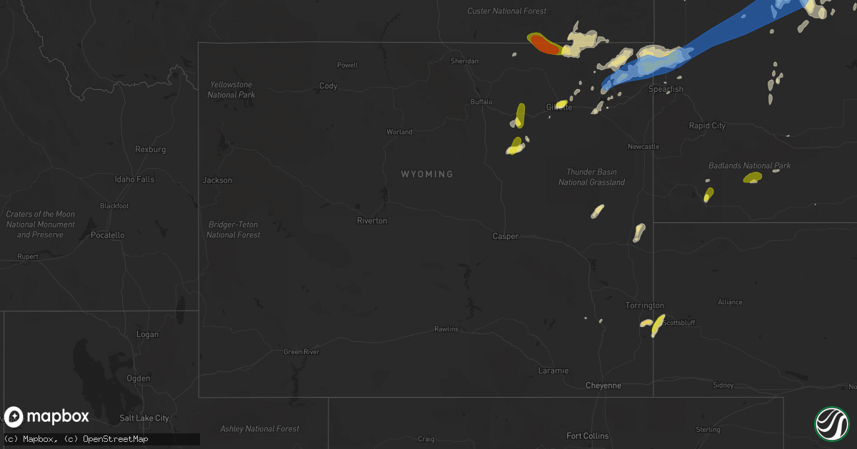
Hail Map in Wyoming on June 26, 2019
Get this storm
June 26 map
$229
one time, instant access
Download today. No call, no setup
Keep the $229
Bought the map and want the full workflow? Apply the entire $229 to a subscription within 7 days. None of it is wasted.
Every map, not just this one
This buys you this map. Subscription and you get every map we run, in the markets you choose from a few cities to whole states to nationwide. Plus real-time alerts the moment a storm fires.
Contact data
Name, contact info, occupancy, even credit band for addresses in the footprint. You go from where it hit to who to call.
Become the source they trust
Unlimited branding weather history reports on demand. You already have the documented answer ready for the property owner, and you are the one who showed up with it.
Property data and RoofTrace estimates
Pull up any address you have got, its value and the exact code rules for that jurisdiction, straight from One Click Code. Then RoofTrace estimates the squares, pitch, and roof value, priced the way you price.
Storm reports in Wyoming
Wyoming
| Date | Description |
|---|---|
| 06/26/20195:01 AM CDT | At 1001 PM MDT, severe thunderstorms were located along a line extending from 2 miles northeast of Alzada to 5 miles north of Aladdin to 3 miles south of Sundance, moving east at 40 mph. HAZARD...70 mph wind gusts and quarter size hail. SOURCE...Radar indicated. IMPACT...Hail damage to vehicles is expected. Expect considerable tree damage. Wind damage is also likely to mobile homes, roofs, and outbuildings. Locations impacted include... Spearfish, Belle Fourche, Lead, Deadwood, Whitewood, Newell, Nisland, Saint Onge, Central City, Colony, Beulah, Fruitdale, Aladdin, Castle Rock, Iron Creek Lake, Roughlock Falls, Savoy, Belle Fourche Reservoir, Two Top Butte and Antelope Butte.This includes... Interstate 90 in South Dakota between Mile Markers 1 and 28. Interstate 90 in Wyoming between Mile Markers 188 and 207. |
| 06/26/20194:24 AM CDT | At 924 PM MDT, a severe thunderstorm was located near Gillette Airport, or 3 miles north of Gillette, moving east at 20 mph. HAZARD...Half dollar size hail. SOURCE...Radar indicated. IMPACT...Damage to vehicles is expected. Locations impacted include... Gillette, Rozet, Camplex Event Facility and Gillette Airport. This includes Interstate 90 in Wyoming between Mile Markers 120 and147. |
| 06/26/20194:21 AM CDT | At 918 PM MDT, severe thunderstorms were located along a line extending from 21 miles west of Ridgeway to near Lightning Flat, moving east at 30 mph. HAZARD...70 mph wind gusts and quarter size hail, along with very heavy rainfall. Localized flash flooding is possible. SOURCE...Radar indicated. A spotter on Highway 212 reported wind gusts as high as 70 mph. IMPACT...Hail damage to vehicles is expected. Expect considerable tree damage. Wind damage is also likely to mobile homes, roofs, and outbuildings. Locations impacted include... Alzada, Ridgeway, Hammond, Belltower, Capitol, Albion, Boyes, Belle Creek and Ridge.This replaces the warning previously in effect for southwestern Carter and southeastern Powder River counties. |
| 06/26/20194:14 AM CDT | At 913 PM MDT, severe thunderstorms were located along a line extending from 8 miles east of Lightning Flat to 6 miles south of New Haven to near Moorcroft, moving east at 30 mph. HAZARD...70 mph wind gusts and half dollar size hail. SOURCE...Radar indicated. IMPACT...Hail damage to vehicles is expected. Expect considerable tree damage. Wind damage is also likely to mobile homes, roofs, and outbuildings. Locations impacted include... Sundance, Moorcroft, Pine Haven, Hulett, Alva, Carlile, Oshoto, New Haven, Lightning Flat, Devils Tower National Monument, Warren Peak, Bear Lodge Campground, Cook Lake, Devils Tower Junction and Keyhole Reservoir.This includes Interstate 90 in Wyoming between Mile Markers 153 and194. |
| 06/26/20193:51 AM CDT | At 851 PM MDT, a severe thunderstorm was located 12 miles north of Rozet, or 21 miles northeast of Gillette, moving east at 35 mph. HAZARD...60 mph wind gusts and half dollar size hail. SOURCE...Radar indicated. IMPACT...Hail damage to vehicles is expected. Expect wind damage to roofs, siding, and trees. Locations impacted include... Moorcroft, Pine Haven, Carlile, Rozet and Keyhole Reservoir. This includes Interstate 90 in Wyoming between Mile Markers 134 and161. |
| 06/26/20193:44 AM CDT | At 841 PM MDT, a severe thunderstorm was located over Biddle, or 25 miles south of Broadus, moving southeast at 30 mph. The strongest portion of this storm should remain south of Highway 212. HAZARD...Golf ball size hail and 60 mph wind gusts, along with very heavy rainfall. SOURCE...Radar indicated. IMPACT...People and animals outdoors will be injured. Expect hail damage to roofs, siding, windows, and vehicles. Expect wind damage to roofs, siding, and trees. Locations impacted include... Biddle, Belle Creek and Ridge. This replaces the warning previously in effect for southeastern Powder River County. |
| 06/26/20193:26 AM CDT | At 826 PM MDT, severe thunderstorms were located along a line extending from 7 miles south of Biddle to 9 miles west of Weston, moving east at 45 mph. HAZARD...Golf ball size hail and 70 mph wind gusts. SOURCE...Radar indicated. IMPACT...People and animals outdoors will be injured. Expect hail damage to roofs, siding, windows, and vehicles. Expect considerable tree damage. Wind damage is also likely to mobile homes, roofs, and outbuildings. Locations impacted include... Lightning Flat, Oshoto, New Haven, Weston, Rockypoint and Devils Tower National Monument. |
| 06/26/20193:08 AM CDT | At 808 PM MDT, a severe thunderstorm was located 8 miles west of Savageton, or 24 miles west of Wright, moving northeast at 25 mph. HAZARD...Half dollar size hail. SOURCE...Radar indicated. IMPACT...Damage to vehicles is expected. Locations impacted include... Savageton and Pumpkin Buttes. |
| 06/26/20192:43 AM CDT | At 740 PM MDT, severe thunderstorms were located along a line extending from 20 miles northwest of Biddle to 20 miles north of Spotted Horse, moving east southeast at 30 mph. These are very dangerous storms. Please take cover now. HAZARD...Up to baseball size hail and 60 mph wind gusts, along with very heavy rainfall. This storm is exhibiting deep rotation and could also produce a tornado. SOURCE...Radar indicated. A spotter 10 miles northeast of Moorhead reported baseball size hail. IMPACT...People and animals outdoors will be severely injured. Expect shattered windows, extensive damage to roofs, siding, and vehicles. Locations impacted include... Biddle, Belle Creek and Moorhead. This replaces the warning previously in effect for southwestern Powder River County. |
| 06/26/20192:31 AM CDT | At 731 PM MDT, a severe thunderstorm was located about 5 miles south of Powder River Rest Area, which is 30 miles west of Gillette moving northeast at 30 mph. Another severe thunderstorm was just north of sussex also moving northeast at 30 mph. HAZARD...Half dollar size hail. SOURCE...Radar indicated. IMPACT...Damage to vehicles is expected. This severe thunderstorm will remain over mainly rural areas of east central Johnson County.This includes Interstate 90 between mile markers 86 and 95. |
| 06/26/20191:53 AM CDT | At 650 PM MDT, a severe thunderstorm was located near Otter, or 39 miles southwest of Broadus, moving east at 25 mph. HAZARD...Golf ball size hail and 60 mph wind gusts, along with very heavy rainfall. This storm has deep rotation and could also produce a tornado. SOURCE...Radar indicated. IMPACT...People and animals outdoors will be injured. Expect hail damage to roofs, siding, windows, and vehicles. Expect wind damage to roofs, siding, and trees. Locations impacted include... Moorhead and Otter. |
| 06/26/201912:58 AM CDT | At 558 PM MDT, a severe thunderstorm was located 7 miles north of Manning Ranch, or 32 miles northeast of Douglas, moving north at 35 mph. HAZARD...60 mph wind gusts and quarter size hail. SOURCE...Radar indicated. IMPACT...Hail damage to vehicles is expected. Expect wind damage to roofs, siding, and trees. Locations impacted include... Dull Center and Manning Ranch. |
| 06/25/201910:40 PM CDT | A local report indicates 60 MPH wind near 6 ENE CARLILE |
| 06/25/201910:30 PM CDT | A local report indicates 1.25 inch wind near 3 ENE DOWNTOWN GILLETTE |
| 06/25/20199:20 PM CDT | A local report indicates 1.75 inch wind near 14 NNE RECLUSE |
| 06/25/20199:20 PM CDT | A local report indicates 60 MPH wind near 14 NNE RECLUSE |
| 06/25/20198:56 PM CDT | A local report indicates 70 MPH wind near 15 NNW RECLUSE |
| 06/25/20198:55 PM CDT | A local report indicates 1.00 inch wind near 15 NNW RECLUSE |
All States Impacted by Hail Map on June 26, 2019
Cities Impacted by Hail Map on June 26, 2019
- Gettysburg, SD
- Huron, SD
- Larchwood, IA
- Portland, TN
- Goodlettsville, TN
- Cottontown, TN
- Hendersonville, TN
- Cross Plains, TN
- Greenbrier, TN
- White House, TN
- Gillette, WY
- Murfreesboro, TN
- Plainfield, IL
- Minooka, IL
- Joliet, IL
- Crossville, IL
- Grayville, IL
- Mulkeytown, IL
- Royalton, IL
- Huntingdon, TN
- Trezevant, TN
- Atwood, TN
- Lexington, AL
- Condon, OR
- Moorcroft, WY
- Island Park, ID
- Vandalia, IL
- Greenville, IL
- Keyesport, IL
- Alma, IL
- Mulberry Grove, IL
- Smithboro, IL
- Kinmundy, IL
- Vernon, IL
- Patoka, IL
- Shobonier, IL
- Saint Louis, MO
- Florissant, MO
- Huntsville, AR
- Witter, AR
- Franklin, GA
- Olney, IL
- Hurley, SD
- Viborg, SD
- Lennox, SD
- Davis, SD
- New Canton, IL
- Pleasant Hill, IL
- Barry, IL
- Rockport, IL
- Elizabeth, AR
- Charleston, MO
- Decker, MT
- Otter, MT
- Jackson, MO
- Tuttle, ND
- Wing, ND
- Biggers, AR
- Bowling Green, KY
- Lock Haven, PA
- Francesville, IN
- Dupree, SD
- Broadus, MT
- Hulett, WY
- Weston, WY
- Alzada, MT
- Willsboro, NY
- Essex, NY
- Lyman, NE
- Warrenton, MO
- Fredericktown, MO
- Perryville, MO
- Sainte Genevieve, MO
- Farmington, MO
- Saint Mary, MO
- Chester, IL
- Slaughters, KY
- Sebree, KY
- Lewiston, ID
- Anatone, WA
- Asotin, WA
- Eddyville, KY
- Darby, MT
- Lodge Grass, MT
- Festus, MO
- Bloomsdale, MO
- Poplar Bluff, MO
- Frankfort, IL
- University Park, IL
- Richton Park, IL
- Monee, IL
- Homewood, IL
- Thornton, IL
- Saint John, IN
- Lansing, IL
- Olympia Fields, IL
- Dyer, IN
- Tinley Park, IL
- Chicago Heights, IL
- Crete, IL
- Glenwood, IL
- Park Forest, IL
- Matteson, IL
- Steger, IL
- Green Forest, AR
- Berryville, AR
- Hanover, KS
- Frazer, MT
- Rensselaer, IN
- Fair Oaks, IN
- Cape Girardeau, MO
- Colman, SD
- Hamilton, MT
- Stockett, MT
- Great Falls, MT
- Cascade, MT
- Wolf Creek, MT
- Canyon Creek, MT
- Rozet, WY
- Medaryville, IN
- Poplar, MT
- Wolf Point, MT
- Scobey, MT
- Philpot, KY
- Flandreau, SD
- Elkton, SD
- Vermillion, SD
- Williamsfield, IL
- Princeville, IL
- Toulon, IL
- Speer, IL
- La Fayette, IL
- Galva, IL
- Victoria, IL
- Laura, IL
- Brimfield, IL
- Altona, IL
- Saint Jacob, IL
- Bloomfield, MO
- Advance, MO
- Puxico, MO
- Kaycee, WY
- Buffalo, WY
- Luverne, MN
- Jasper, MN
- Garretson, SD
- Hardwick, MN
- Mountain Home, AR
- Hot Springs, SD
- Prairie City, SD
- Washington, MO
- Pilot Knob, MO
- Arcadia, MO
- Lesterville, MO
- Annapolis, MO
- Ironton, MO
- Middle Brook, MO
- Minneota, MN
- Taunton, MN
- Porter, MN
- Canby, MN
- Meadow, SD
- Demotte, IN
- Madison, SD
- Lusk, WY
- Vergennes, IL
- Du Quoin, IL
- Elkville, IL
- Rockvale, TN
- Birney, MT
- Alexandria, SD
- Dundee, KY
- Hartford, KY
- Fordsville, KY
- Olaton, KY
- Water Valley, KY
- Union City, TN
- Martin, TN
- Fulton, KY
- Wingo, KY
- South Fulton, TN
- Valparaiso, IN
- Eagleville, TN
- Dwight, IL
- Gardner, IL
- George, IA
- Doon, IA
- Thomaston, GA
- Milnor, ND
- Cayuga, ND
- Pickrell, NE
- Cortland, NE
- Lebanon, TN
- Xenia, IL
- Johnsonville, IL
- Topeka, IN
- Millersburg, IN
- Shipshewana, IN
- Clearwater, NE
- Oakdale, NE
- Grafton, IL
- Portage Des Sioux, MO
- Woodburn, KY
- Auburn, KY
- Russellville, KY
- Franklin, KY
- Adairville, KY
- Hemphill, TX
- Elgin, IL
- Roselle, IL
- Saint Charles, IL
- Bartlett, IL
- Streamwood, IL
- Hanover Park, IL
- Wayne, IL
- Schaumburg, IL
- Colfax, ND
- Aberdeen, SD
- Westport, SD
- Dyersburg, TN
- Ripley, TN
- Friendship, TN
- Halls, TN
- Wentworth, SD
- Lake Preston, SD
- Erwin, SD
- Plymouth, NE
- New Haven, MO
- Potosi, MO
- Sullivan, MO
- Elkton, KY
- Iroquois, SD
- De Smet, SD
- Bryant, SD
- New Lenox, IL
- Mokena, IL
- Hammond, MT
- Boyes, MT
- Marion, KY
- Culdesac, ID
- Lenore, ID
- Ashwood, OR
- Estelline, SD
- Mission Hill, SD
- Yankton, SD
- Lesterville, SD
- Tabor, SD
- Irene, SD
- Utica, SD
- Volin, SD
- Alcester, SD
- Hawarden, IA
- Hudson, SD
- Murdo, SD
- Draper, SD
- Springfield, MO
- Willard, MO
- Bois D Arc, MO
- Smithwick, SD
- Oral, SD
- Lobelville, TN
- Effie, LA
- East Saint Louis, IL
- Miller City, IL
- Mounds, IL
- Sikeston, MO
- New Madrid, MO
- Matthews, MO
- East Prairie, MO
- Bertrand, MO
- Cairo, IL
- Mitchell, NE
- Yoder, WY
- Morrill, NE
- Howard, SD
- Canova, SD
- Belle Fourche, SD
- Noble, IL
- Henning, TN
- Ireton, IA
- Rock Valley, IA
- Sioux Center, IA
- Rock Rapids, IA
- Elk Point, SD
- Hull, IA
- McIntosh, SD
- Keldron, SD
- Alva, WY
- Willow Lake, SD
- Hoven, SD
- Madison, TN
- Nashville, TN
- Old Hickory, TN
- Aurora, IL
- Wright City, MO
- East Carondelet, IL
- Fenton, MO
- Exeter, MO
- Cassville, MO
- Tyndall, SD
- Scotland, SD
- Wakonda, SD
- Centerville, SD
- Genesee, ID
- Albion, NE
- Mcminnville, TN
- Collinsville, AL
- Alvaton, KY
- Fulton, SD
- Collinsville, IL
- Troy, IL
- O'Fallon, IL
- Pocahontas, AR
- Maynard, AR
- Sedan, NM
- Santa Rosa, NM
- Locke, NY
- Moravia, NY
- Mandan, ND
- Yorkville, IL
- Portageville, MO
- Sugar Grove, IL
- Ethan, SD
- Mooreton, ND
- Hinsdale, IL
- Oak Brook, IL
- Westmont, IL
- Clarendon Hills, IL
- Benton, MO
- Scott City, MO
- Saint Anne, IL
- Pembroke Township, IL
- The Rock, GA
- Colton, SD
- Dell Rapids, SD
- Baltic, SD
- Maple Park, IL
- Romeoville, IL
- Oswego, IL
- Bolingbrook, IL
- Elburn, IL
- Naperville, IL
- Montgomery, IL
- North Aurora, IL
- Quinter, KS
- Gove, KS
- Ozone, AR
- Faulkton, SD
- Onaka, SD
- Seneca, SD
- Wana, WV
- Holbrook, PA
- Aleppo, PA
- New Freeport, PA
- Williamsville, MO
- Horse Branch, KY
- Cromwell, KY
- Beaver Dam, KY
- Whitesville, KY
- Utica, KY
- Owensboro, KY
- Lewisport, KY
- Maceo, KY
- Boyd, MN
- Enderlin, ND
- Gallatin, TN
- Shreveport, LA
- Harrison, AR
- Compton, AR
- Alpena, AR
- Kennebec, SD
- Keithville, LA
- Dudley, MO
- Cherokee Village, AR
- Hardy, AR
- New Haven, IN
- Monroeville, IN
- Woodburn, IN
- Cottonwood, MN
- Peotone, IL
- Beecher, IL
- Sycamore, PA
- West Finley, PA
- Graysville, PA
- Waynesburg, PA
- Douglas, WY
- Lance Creek, WY
- Shawnee, WY
- Arnold, MO
- House, NM
- Elsberry, MO
- Watauga, SD
- Holcomb, MO
- Piggott, AR
- Greenway, AR
- Rector, AR
- Taft, TN
- Grant Park, IL
- Momence, IL
- Campbell Hill, IL
- Pinckneyville, IL
- Cutler, IL
- Ava, IL
- Roosevelt, WA
- Goldendale, WA
- Franklin, AR
- Kendrick, ID
- Lisbon, ND
- Vidalia, LA
- Sundance, WY
- Volga, SD
- Arlington, SD
- Garrison, MT
- Alton, MO
- Doniphan, MO
- Fremont, MO
- Ravenden, AR
- Canistota, SD
- Salem, SD
- Gassville, AR
- Center Sandwich, NH
- Moultonborough, NH
- Government Camp, OR
- Welches, OR
- Rhododendron, OR
- Lapwai, ID
- Linton, ND
- Leslie, MO
- Beaufort, MO
- Greenville, KY
- Holland, MN
- Ruthton, MN
- Goshen, IN
- Ligonier, IN
- Middlebury, IN
- Truesdale, MO
- Thayer, MO
- Drakesboro, KY
- Eolia, MO
- Silex, MO
- Beresford, SD
- Canton, SD
- Parker, SD
- Rockfield, KY
- Schroon Lake, NY
- Goodland, IN
- Remington, IN
- Jasper, TX
- Newton, TX
- Troy, NY
- Cropseyville, NY
- Hobson, MT
- Wessington, SD
- Bragg City, MO
- Steele, MO
- Hayti, MO
- Caruthersville, MO
- Gold Creek, MT
- Ione, OR
- Boardman, OR
- North Liberty, IN
- Parma, MO
- Catron, MO
- Kadoka, SD
- Clarks, NE
- Stromsburg, NE
- Koshkonong, MO
- Labelle, FL
- Mitchell, SD
- Highmore, SD
- Kountze, TX
- Willowbrook, IL
- Lemont, IL
- Willow Springs, IL
- Salem, KY
- Trent, SD
- Wolcott, IN
- Monon, IN
- Fairview, WV
- Marthasville, MO
- Doe Run, MO
- Naylor, MO
- Oxly, MO
- Pollard, AR
- Torrington, WY
- Benedict, NE
- Florien, LA
- Richwoods, MO
- Coushatta, LA
- Webster, SD
- Hindsville, AR
- Howes, SD
- Spencer, SD
- Claremont, IL
- Belleview, MO
- Caledonia, MO
- Belgrade, MO
- Dimock, SD
- Troy, MO
- Dieterich, IL
- Mason, IL
- Louisville, IL
- Moore, MT
- Wall, SD
- Christiana, TN
- McKenzie, TN
- Aladdin, WY
- Worthing, SD
- Clarkston, WA
- Gann Valley, SD
- French Village, MO
- Bonne Terre, MO
- Morgantown, KY
- Silsbee, TX
- Lumberton, TX
- Bison, SD
- Cedar Lake, IN
- Wanatah, IN
- Westville, IN
- Greenville, MO
- Isabel, SD
- Edwardsville, IL
- Kingston, AR
- Marble Falls, AR
- Madison, MN
- Montrose, SD
- Clarksville, MO
- Dawson, ND
- La Porte, IN
- Union Mills, IN
- Park Hills, MO
- Presho, SD
- Vivian, SD
- Gayville, SD
- Fordyce, NE
- Saint Helena, NE
- Reynolds, IN
- Patterson, MO
- Piedmont, MO
- Lake Norden, SD
- Badger, SD
- Ellendale, ND
- Forbes, ND
- Jerseyville, IL
- Kenton, TN
- Mount Juliet, TN
- Naples, FL
- Fredonia, KY
- Barney, ND
- Wyndmere, ND
- Clearwater, FL
- Sutton, NE
- Ravenden Springs, AR
- Warm Springs, AR
- Bernie, MO
- Cave In Rock, IL
- Jonesburg, MO
- Pocahontas, IL
- Inwood, IA
- Imperial, MO
- Barnhart, MO
- McLaughlin, SD
- Cazenovia, NY
- Imboden, AR
- Winfred, SD
- Darien, IL
- Woodridge, IL
- Palos Park, IL
- Downers Grove, IL
- Evans, LA
- Killen, AL
- Florence, AL
- Lewisburg, KY
- Central City, KY
- Hopkinsville, KY
- Beech Creek, KY
- Sikes, LA
- Winnfield, LA
- Olla, LA
- Fort Pierre, SD
- Woodland, AL
- Gering, NE
- Fossil, OR
- Palco, KS
- Woodstock, MN
- Morocco, IN
- Lake Village, IN
- Ree Heights, SD
- Mazon, IL
- Oak Ridge, MO
- Pembroke, KY
- Trenton, KY
- Dresden, TN
- Sharon, TN
- Chancellor, SD
- Hartford, SD
- Golden Gate, IL
- Mount Erie, IL
- Ellery, IL
- Fairfield, IL
- Cisne, IL
- Springdale, AR
- Fayetteville, AR
- Decatur, AL
- Danville, AL
- Marston, MO
- Selby, SD
- Pipestone, MN
- Bloomingdale, IL
- Medinah, IL
- Itasca, IL
- Addison, IL
- Flat Rock, IL
- Highland, IL
- Ewing, NE
- Miller, SD
- New Douglas, IL
- Alhambra, IL
- Henderson, TN
- Faith, SD
- Erie, MI
- Geff, IL
- Sims, IL
- Kyle, SD
- Pine Ridge, SD
- Lawrenceville, IL
- Reynolds Station, KY
- Bethpage, TN
- Horseshoe Bend, AR
- Punta Gorda, FL
- Nunnelly, TN
- Lebanon, SD
- Fairbury, NE
- Jansen, NE
- Yellville, AR
- Summit, AR
- Olivet, SD
- Parkston, SD
- Emery, SD
- Roopville, GA
- Wakeeney, KS
- Yatesville, GA
- Marion, MT
- Monett, MO
- Pierce City, MO
- Purdy, MO
- Ludlow, SD
- Indiantown, FL
- Port Charlotte, FL
- Philipsburg, MT
- Wolcottville, IN
- Lascassas, TN
- Buffalo, SD
- Carpenter, SD
- Paw Paw, IL
- Lee, IL
- Shabbona, IL
- Steward, IL
- Harvey, IL
- Hazel Crest, IL
- Markham, IL
- Yeso, NM
- Broseley, MO
- Odell, NE
- Wymore, NE
- Avon, SD
- Niobrara, NE
- Louisiana, MO
- Calhoun, IL
- Parkersburg, IL
- Mascoutah, IL
- Sardis, TN
- Placida, FL
- Stonewall, LA
- Tappen, ND
- Pettibone, ND
- Mammoth Spring, AR
- Camp, AR
- Upton, WY
- Prosser, WA
- Bridgewater, SD
- Hall, MT
- Steen, MN
- Bourbon, MO
- Whitewater, MO
- Charlotte, VT
- Shelburne, VT
- Harviell, MO
- Homer Glen, IL
- Pittsfield, IL
- Gobler, MO
- Waubay, SD
- Chambersburg, IL
- Ingraham, IL
- Clayton, NM
- Chester, SD
- Lockport, IL
- Prairie Du Rocher, IL
- Red Bud, IL
- Evansville, IL
- Ellis Grove, IL
- Modoc, IL
- Bruceton, TN
- Buena Vista, TN
- Hartington, NE
- Wynot, NE
- Rosine, KY
- Hampton, KY
- Beaver Creek, MN
- Albers, IL
- Deerfield, MO
- Winamac, IN
- Valley Springs, AR
- Alamo, TN
- Centerville, TN
- Linden, TN
- Enville, TN
- Black Rock, AR
- Wind Ridge, PA
- West Alexander, PA
- Triadelphia, WV
- Dallas, WV
- Farina, IL
- Saint Peter, IL
- Channahon, IL
- Houston, TX
- Spraggs, PA
- Campbell, MO
- Malden, MO
- Clarkton, MO
- Gideon, MO
- Chambers, NE
- Carmi, IL
- Falls Of Rough, KY
- Shelby, NE
- Grandin, MO
- Texline, TX
- Caseyville, IL
- Flippin, AR
- Gleason, TN
- Brooks, GA
- Roscoe, SD
- Ash Grove, MO
- Everton, MO
- Walnut Grove, MO
- Rising City, NE
- Humboldt, SD
- Clinton, KY
- Lawrenceburg, TN
- Elgin, NE
- Williford, AR
- Cannon Ball, ND
- Martell, NE
- Hallam, NE
- Langford, SD
- Menno, SD
- Burnt Prairie, IL
- Tamms, IL
- Granite Falls, MN
- Antelope, OR
- Randolph, NE
- Mclean, NE
- Hope, NM
- Lake Wilson, MN
- Balaton, MN
- Valley Falls, NY
- Johnsonville, NY
- Columbus, KS
- Scammon, KS
- Cherokee, KS
- Weir, KS
- Pulaski, IL
- Olmsted, IL
- Dongola, IL
- Ullin, IL
- Gilmer, TX
- Clubb, MO
- Lowndes, MO
- Washburn, MO
- Fort Thompson, SD
- Ash Flat, AR
- Oakes, ND
- Alexander, IL
- New Berlin, IL
- Brookeland, TX
- Peck, ID
- Reubens, ID
- Devils Tower, WY
- Yale, SD
- Flora, IL
- Clay City, IL
- Marksville, LA
- Deville, LA
- Glenham, SD
- Corsica, SD
- Armour, SD
- Rumsey, KY
- Lowell, IN
- Hebron, IN
- Shell Knob, MO
- Bruce, SD
- Worden, IL
- Scottsville, KY
- Eagle Butte, SD
- Munnsville, NY
- Oneida, NY
- Shaniko, OR
- Hills, MN
- Johnstown, NE
- Kathryn, ND
- Fort Ransom, ND
- Odin, IL
- Salem, IL
- West Frankfort, IL
- Fisk, MO
- Dexter, MO
- Orland Park, IL
- Palos Heights, IL
- Litchfield, IL
- Fort Payne, AL
- Immokalee, FL
- Clearmont, WY
- High Ridge, MO
- Eureka, MO
- Millstadt, IL
- Ballwin, MO
- Wildwood, MO
- Maryville, IL
- Valley Park, MO
- Lebanon, IL
- Belleville, IL
- Granite City, IL
- Dupo, IL
- Chesterfield, MO
- Columbia, IL
- Bismarck, MO
- Bonita Springs, FL
- Saint Lawrence, SD
- Kouts, IN
- Belton, KY
- Dunmor, KY
- Burbank, SD
- Dittmer, MO
- De Soto, MO
- Fletcher, MO
- Hillsboro, MO
- Pettigrew, AR
- Kentland, IN
- Brook, IN
- Anderson, AL
- Petersburg, NY
- Averill Park, NY
- Vincennes, IN
- Java, SD
- Battletown, KY
- Van Buren, MO
- Lafe, AR
- Trinity, AL
- Cooter, MO
- Toronto, SD
- Brussels, IL
- Batchtown, IL
- Lead Hill, AR
- Burfordville, MO
- Spearfish, SD
- Crown Point, IN
- Thayer, IN
- Wheatfield, IN
- Schneider, IN
- South Holland, IL
- Bourbonnais, IL
- Munster, IN
- Shelby, IN
- Schererville, IN
- Kankakee, IL
- Highland, IN
- Hammond, IN
- Gerald, MO
- Newcastle, NE
- Little Rock, IA
- Palm Harbor, FL
- Alvord, IA
- Golden City, MO
- Clear Lake, SD
- Kinderhook, IL
- Timber Lake, SD
- Glencoe, AR
- Taiban, NM
- Bismarck, ND
- Cape Coral, FL
- Waterman, IL
- Selfridge, ND
- Oshkosh, NE
- Surprise, NE
- Locust Gap, PA
- Hegins, PA
- Springfield, TN
- Irondale, MO
- Ochopee, FL
- Litchville, ND
- West Alton, MO
- Everton, AR
- Garland, KS
- Fort Sumner, NM
- Braidwood, IL
- Bridgeport, NE
- Nokomis, IL
- Barneston, NE
- Newman Grove, NE
- Marquand, MO
- Browder, KY
- Tripp, SD
- Rives, TN
- Mayfield, KY
- Findlay, OH
- Alvada, OH
- Ramona, SD
- Mechanicville, NY
- Clifton Park, NY
- Lampe, MO
- Marthaville, LA
- Calico Rock, AR
- Cotter, AR
- Viola, AR
- Wappapello, MO
- Encinal, TX
- Staplehurst, NE
- Seward, NE
- York, NE
- Westmoreland, TN
- Fyffe, AL
- Elwood, IL
- West Chicago, IL
- Hermitage, TN
- Wolsey, SD
- Dalhart, TX
- Okeechobee, FL
- Dadeville, MO
- Adolphus, KY
- Bickleton, WA
- Hardinsburg, KY
- Pleasant Plains, IL
- Cantrall, IL
- Freeman, SD
- Gary, IN
- East Chicago, IN
- Dundas, IL
- Sturkie, AR
- Salem, AR
- Town Creek, AL
- Russellville, AL
- Pierre, SD
- Kirbyville, TX
- Jacks Creek, TN
- Valley Springs, SD
- Tuthill, SD
- Natchitoches, LA
- Woodville, MS
- Natchez, MS
- Callicoon, NY
- Spurger, TX
- Mansfield, LA
- Boca Grande, FL
- New Leipzig, ND
- Marion, SD
- Cypress, IL
- Damascus, PA
- Nebo, IL
- Brownstown, IL
- Gibson, MO
- Qulin, MO
- Camden, TN
- Hanson, KY
- Agar, SD
- Buffalo Gap, SD
- Wheatland, WY
- Greenfield, TN
- Hawk Point, MO
- Vulcan, MO
- Onida, SD
- Wagner, SD
- Marble Hill, MO
- Coleridge, NE
- Edgewood, IL
- Provencal, LA
- Monticello, IN
- Mcleod, ND
- Crown Point, NY
- Volborg, MT
- Powderville, MT
- Recluse, WY
- Galena, KS
- Pittsburg, KS
- Mud Butte, SD
- Newell, SD
- Beulah, WY
- Morristown, SD


