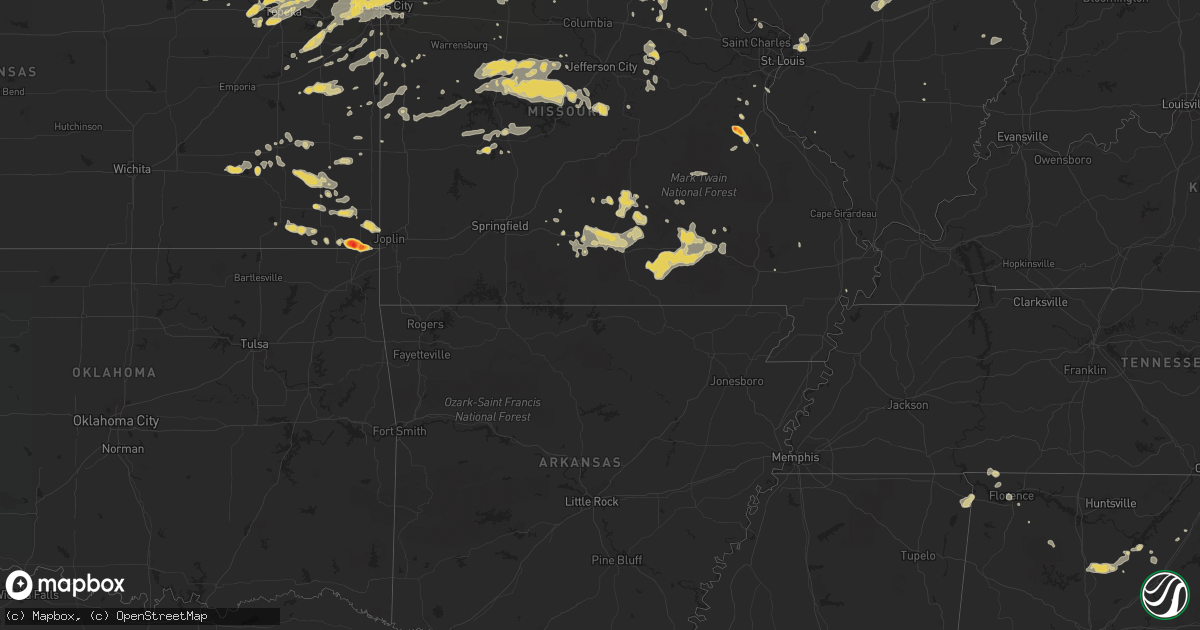
Hail Map in Missouri on June 26, 2011
Get this storm
June 26 map
$229
one time, instant access
Download today. No call, no setup
Keep the $229
Bought the map and want the full workflow? Apply the entire $229 to a subscription within 7 days. None of it is wasted.
Every map, not just this one
This buys you this map. Subscription and you get every map we run, in the markets you choose from a few cities to whole states to nationwide. Plus real-time alerts the moment a storm fires.
Contact data
Name, contact info, occupancy, even credit band for addresses in the footprint. You go from where it hit to who to call.
Become the source they trust
Unlimited branding weather history reports on demand. You already have the documented answer ready for the property owner, and you are the one who showed up with it.
Property data and RoofTrace estimates
Pull up any address you have got, its value and the exact code rules for that jurisdiction, straight from One Click Code. Then RoofTrace estimates the squares, pitch, and roof value, priced the way you price.
Storm reports in Missouri
Missouri
| Date | Description |
|---|---|
| 06/26/20114:53 PM CDT | Shreading leaves off of trees. Also rotating wall cloud passed directly overhead. This is second round of large hail spotter has received |
| 06/26/20114:40 PM CDT | Trees reported down in the community. |
| 06/26/20114:33 PM CDT | A local report indicates 1.00 inch wind near BLACKWELL |
| 06/26/20114:32 PM CDT | A local report indicates 1.50 inch wind near CADET |
| 06/26/20114:19 PM CDT | A local report indicates 60 MPH wind near 4 ENE OLD MINES |
| 06/26/20114:15 PM CDT | A local report indicates 1.75 inch wind near 4 ENE OLD MINES |
| 06/26/20113:11 PM CDT | A local report indicates 1.00 inch wind near 2 N PRESCOTT |
| 06/26/20113:05 PM CDT | Mixed quarter and half dollar sized hail reported. Lightly covering groud. |
| 06/26/20112:40 PM CDT | A local report indicates 1.00 inch wind near CABOOL |
| 06/26/20112:39 PM CDT | One inch hail reported at route 60 and route 181 intersection. |
| 06/26/20112:35 PM CDT | One barn destroyed and power lines down. |
| 06/26/20112:05 PM CDT | A local report indicates 1.00 inch wind near NORWOOD |
| 06/26/201111:30 AM CDT | Tree blocking us highway 65. |
| 06/26/20115:35 AM CDT | Large tree down on home at 35th and woodland |
| 06/26/20115:30 AM CDT | Tree fell onto a home. Numerous large limbs down. |
| 06/26/20115:15 AM CDT | Multiple large tree limbs down near n indiana and ne antioch rd. Estimated gust 60 mph. |
| 06/26/20112:42 AM CDT | A local report indicates 1.00 inch wind near GRAY SUMMIT |
| 06/26/20112:42 AM CDT | A local report indicates 65 MPH wind near GRAY SUMMIT |
| 06/26/20112:39 AM CDT | A local report indicates 63 MPH wind near 4 SW FENTON |
| 06/26/20112:33 AM CDT | A local report indicates 65 MPH wind near DRAKE |
| 06/26/20112:32 AM CDT | Up to 3 inch diameter branches snapped off trees. Large trash dumpsters blown out onto the streets. |
| 06/26/20112:25 AM CDT | A local report indicates 1.50 inch wind near CARROLLTON |
| 06/26/20112:22 AM CDT | A local report indicates 65 MPH wind near DRAKE |
| 06/26/20112:16 AM CDT | A local report indicates 70 MPH wind near NEW HAVEN |
| 06/26/20112:15 AM CDT | Up to 3 inch diameter branches snapped off trees. Large trash dumpsters blown out onto the streets. |
| 06/26/20112:00 AM CDT | Power lines down...wright city also |
| 06/26/20112:00 AM CDT | A large tree was blown over onto a car on roosevelt avenue. |
| 06/26/20111:30 AM CDT | A local report indicates 80 MPH wind near 6 NW NEW HARTFORD |
| 06/26/20111:30 AM CDT | Large tree damage reported all across the northern half of the county |
| 06/26/20111:30 AM CDT | Trees damaged and uprooted. Time estimated from radar. |
| 06/26/20111:30 AM CDT | Dime size hail...across the road from the airport |
| 06/26/20111:28 AM CDT | A local report indicates 62 MPH wind near 4 NNE ASHLAND |
| 06/26/20111:28 AM CDT | Several trees blown down. One tree was blocking log providence road north of ashland. |
| 06/26/20111:27 AM CDT | A local report indicates 61 MPH wind near 3 WNW HANNIBAL |
| 06/26/20111:25 AM CDT | Several large trees blown down in town. |
| 06/26/20111:20 AM CDT | Measured at lock and dam 20 |
| 06/26/20111:15 AM CDT | Several trees uprooted as well |
| 06/26/20111:14 AM CDT | Roof partially blown off of a building near potterfield trucking on u.s. Highway 24 36 east. |
| 06/26/20111:14 AM CDT | Several trees blown down on west side of town. |
| 06/26/20111:07 AM CDT | Heavy rain is occurring with the hail. |
| 06/26/20111:07 AM CDT | 5-6 inch limbs down...quarter sized hail. |
| 06/26/20111:07 AM CDT | 5-6 inch limbs down...quarter sized hail. |
| 06/26/20111:03 AM CDT | Estimated 50-60 wind gusts...power is out as well. |
| 06/26/20111:00 AM CDT | Several trees blown down in northwestern portions of county. |
| 06/26/201112:55 AM CDT | Damage reported all across lewis county...large trees down...power lines down...several mobile homes destroyed...other structural damage countywide. |
| 06/26/201112:55 AM CDT | Two to three foot diameter trees uprooted in town...one two and a half foot diameter tree snapped off at base. |
| 06/26/201112:55 AM CDT | Three to five trees blown down in yard. One tree was at least 10 inches in diameter. |
| 06/26/201112:46 AM CDT | Thunderstorm wind gusts estimated up to 70 mph. Many tree branches down. Swing set blown over. |
| 06/26/201112:45 AM CDT | Part of roof blown off a house and shingles and sheeting blown off. |
| 06/26/201112:45 AM CDT | Trees...tree limbs and power lines down throughout town...from chiel of police |
| 06/26/201112:45 AM CDT | Small building 15 ft up into a tree. 5 rec vehicles overturned. |
| 06/26/201112:43 AM CDT | 3 ft diameter trees uprooted power lines down |
| 06/26/201112:40 AM CDT | Up to three foot diameter trees downed |
| 06/26/201112:38 AM CDT | Thunderstorm wind gusts estimated up to 70 mph. Electricity is out and branches are blown down. |
| 06/26/201112:30 AM CDT | Trees down in town. Time estimated. |
| 06/26/201112:27 AM CDT | Trees and power lines down countywide...between 1227 am and 1 am. |
| 06/26/201112:26 AM CDT | Thunderstorm wind gusts estimated up to 70 mph. Also reported nickel sized hail. |
| 06/26/201112:22 AM CDT | Estimated gusts to 60 mph. |
| 06/26/201112:20 AM CDT | Car port damaged and multiple trees blown down. |
| 06/26/201112:19 AM CDT | Multiple reports of power lines down. |
| 06/26/201112:19 AM CDT | Possible funnel cloud also spotted at this location. |
| 06/26/201112:15 AM CDT | Power poles blown down. Time estimated. |
| 06/26/201112:10 AM CDT | A local report indicates 70 MPH wind near KIRKSVILLE |
| 06/26/201112:08 AM CDT | A local report indicates 71 MPH wind near MILAN |
| 06/26/201112:01 AM CDT | Emergency manager reports at cameron memorial airport wind damage of tied down airplane flipped over. Numerous untied airplanes moved around no damage. Rainfall amount |
| 06/25/201111:55 PM CDT | A local report indicates 70 MPH wind near 4 W NOVINGER |
| 06/25/201111:55 PM CDT | Numerous power lines down |
| 06/25/201111:54 PM CDT | A local report indicates 71 MPH wind near MILAN |
| 06/25/201111:52 PM CDT | A local report indicates 60 MPH wind near BRAYMER |
| 06/25/201111:50 PM CDT | A local report indicates 70 MPH wind near 1 SSW LAREDO |
| 06/25/201111:47 PM CDT | Large tree down |
| 06/25/201111:45 PM CDT | Large tree fell and caused gas leak. |
| 06/25/201111:41 PM CDT | Numerous trees down in gallatin. Power is out. |
| 06/25/201111:36 PM CDT | Trees and power lines down on tindall ave in trenton. |
| 06/25/201111:30 PM CDT | Tree blocking us highway 65. |
| 06/25/201111:25 PM CDT | Very heavy rain and pea-sized hail as well. |
| 06/25/201111:20 PM CDT | Large tree limb down. Power out in mill grove. |
| 06/25/201111:12 PM CDT | 60 mph wind speed...estimated. |
| 06/25/201111:12 PM CDT | A local report indicates 1.00 inch wind near KING CITY |
| 06/25/201111:12 PM CDT | Power lines blown down in bethany. Time estimated. |
| 06/25/201111:10 PM CDT | Large tree limbs down. |
| 06/25/201111:01 PM CDT | Large hail falling concurrent with 60 to 65 mph winds. |
| 06/25/201111:00 PM CDT | Trees and power lines down. |
| 06/25/201111:00 PM CDT | Trees and power lines down. |
| 06/25/201111:00 PM CDT | Power lines down |
| 06/25/201110:58 PM CDT | 60 to 65 mph wind speed estimated. |
| 06/25/201110:55 PM CDT | Numerous branches down with thunderstorm wind gusts to 60 mph. |
| 06/25/201110:55 PM CDT | Tree limbs and power lines down. |
| 06/25/201110:52 PM CDT | 30 foot metal horse trailer blown over on its side. Numerous large tree limbs down. Thunderstorm wind gusts were estimated to 60 mph. |
| 06/25/201110:42 PM CDT | 6-10 inch tree limbs down at the intersection of hwy 129 and cc |
| 06/25/201110:31 PM CDT | Also dime size hail. |
| 06/25/201110:31 PM CDT | Tree blown down on car. Time estimated. |
| 06/25/201110:19 PM CDT | Two to three inch tree limbs reported down with power outages in town. |
| 06/25/201110:19 PM CDT | One large tree fell down on power line. Power out in town. Several large tree limbs also knocked down. Thunderstorm wind gusts estimated up to 60 mph. |
| 06/25/201110:15 PM CDT | Tree blown down. Time estimated. |
| 06/25/20119:30 PM CDT | Quarter size hail just west southwest of monticello on highway 16 |
| 06/25/20118:47 PM CDT | Pea to quarter size hail and one inch of rain with the storm. |
| 06/25/20117:52 PM CDT | A local report indicates 1.75 inch wind near 5 E QUITMAN |
| 06/25/20117:50 PM CDT | Media reports brief spin up with light debris. |
| 06/25/20117:40 PM CDT | A local report indicates 1.25 inch wind near 5 E QUITMAN |
All States Impacted by Hail Map on June 26, 2011
Cities Impacted by Hail Map on June 26, 2011
- Dent, MN
- Staples, MN
- Verndale, MN
- Rochert, MN
- Schaller, IA
- Alta, IA
- Rembrandt, IA
- Storm Lake, IA
- Royal, NE
- Ewing, NE
- Creighton, NE
- Brunswick, NE
- Orchard, NE
- Winnetoon, NE
- Page, NE
- Plainview, NE
- Stanton, NE
- Hyannis, NE
- Merriman, NE
- Whitman, NE
- Ashby, NE
- Ogden, IA
- Rippey, IA
- Perry, IA
- Menlo, IA
- Harrisburg, NE
- Dexter, IA
- Guthrie Center, IA
- Arthur, NE
- Plattsmouth, NE
- Louisville, NE
- Murray, IA
- Truro, IA
- Sidney, IA
- Randolph, IA
- Russell, IA
- Chariton, IA
- Burlington, IA
- Wever, IA
- Lomax, IL
- Carman, IL
- Gravity, IA
- Bedford, IA
- Harvard, NE
- Saronville, NE
- Sutton, NE
- Clay Center, NE
- West Point, IA
- Fort Madison, IA
- Peru, NE
- Nebraska City, NE
- Rock Port, MO
- Novinger, MO
- Green City, MO
- Unionville, MO
- Green Castle, MO
- Dallas City, IL
- Carthage, IL
- Brashear, MO
- Kirksville, MO
- Greentop, MO
- Queen City, MO
- Clyde, MO
- Stanberry, MO
- Conception Junction, MO
- Conception, MO
- Spickard, MO
- Milan, MO
- Stratton, NE
- Trenton, NE
- Beason, IL
- Maroa, IL
- Harristown, IL
- Decatur, IL
- Warrensburg, IL
- Niantic, IL
- Chestnut, IL
- Forsyth, IL
- Latham, IL
- Mount Pulaski, IL
- Liberty, NE
- Bremen, KS
- Oketo, KS
- Hollenberg, KS
- Beattie, KS
- Marysville, KS
- Hanover, KS
- Perry, MO
- Laddonia, MO
- Axtell, KS
- Frankfort, KS
- Havensville, KS
- Divernon, IL
- Leavenworth, KS
- Weston, MO
- Fort Leavenworth, KS
- Carrollton, MO
- Bowling Green, MO
- Delia, KS
- Mission, KS
- Kansas City, KS
- Cowden, IL
- Ramsey, IL
- Herrick, IL
- Meta, MO
- Dixon, MO
- Saint Elizabeth, MO
- Lincoln, MO
- Windsor, MO
- Rhineland, MO
- Chamois, MO
- Morrison, MO
- Hermann, MO
- Manhattan, KS
- Saint George, KS
- Columbus, KS
- Galena, KS
- Carl Junction, MO
- Hartshorn, MO
- Raymondville, MO
- Eunice, MO
- Summersville, MO
- Yukon, MO
- Cherokee, KS
- Scammon, KS
- West Mineral, KS
- McCune, KS
- Watkinsville, GA
- Chetopa, KS
- Cabool, MO
- Mountain Grove, MO
- Mountain View, MO
- Vanzant, MO
- Elk Creek, MO
- Willow Springs, MO
- Florence, AL
- Cypress Inn, TN
- Waterloo, AL
- Tishomingo, MS
- Iuka, MS
- Cherokee, AL
- Pine Apple, AL
- Statesboro, GA
- Glenwood, GA
- Alamo, GA
- Dawson, GA
- Yemassee, SC
- Chauncey, GA
- Cadwell, GA
- McRae Helena, GA
- Clayton, AL
- Norcross, MN
- Chipley, FL
- Elbow Lake, MN
- Quincy, FL
- Kulm, ND
- Laurel Hill, FL
- Defuniak Springs, FL
- Crestview, FL
- Hammond, MT
- Howes, SD
- Wasta, SD
- Worland, WY
- Manderson, WY
- Mullen, NE
- Gordon, NE
- Cody, NE
- Bingham, NE
- Valentine, NE
- Thedford, NE
- Seneca, NE
- Lindsay, NE
- Newman Grove, NE
- Meadow Grove, NE
- Madison, NE
- Albion, NE
- Battle Creek, NE
- Norfolk, NE
- Logan, IA
- Portsmouth, IA
- Woodbine, IA
- Stuart, IA
- Griswold, IA
- Elliott, IA
- Bridgewater, IA
- Orient, IA
- Fontanelle, IA
- Corning, IA
- Cumberland, IA
- Villisca, IA
- Red Oak, IA
- Creston, IA
- Grant, IA
- Prescott, IA
- Massena, IA
- Pleasant Dale, NE
- Seward, NE
- Raymond, NE
- Malcolm, NE
- Garland, NE
- Bee, NE
- Woodburn, IA
- Derby, IA
- Weldon, IA
- Wellfleet, NE
- North Platte, NE
- Eagleville, MO
- Blythedale, MO
- Lamoni, IA
- Max, NE
- Maywood, NE
- Maxwell, NE
- Moorefield, NE
- Brady, NE
- Curtis, NE
- Camden, IL
- Mount Sterling, IL
- Lincoln, IL
- Tonganoxie, KS
- Marshall, IL
- Atwood, KS
- Fairbury, NE
- Endicott, NE
- Pawnee, IL
- Sedalia, MO
- Florence, MO
- Green Ridge, MO
- Mora, MO
- Smithton, MO
- Syracuse, MO
- Ionia, MO
- Harrisonville, MO
- Galesburg, KS
- Erie, KS
- Chanute, KS
- Fall River, KS
- Fredonia, KS
- Guntersville, AL
- Salem, AL
- Opelika, AL
- La Fayette, GA
- Rock Spring, GA
- Rutherfordton, NC
- Dry Branch, GA
- Warwick, GA
- Ashburn, GA
- Arabi, GA
- Hinesville, GA
- Ludowici, GA
- Hilliard, FL
- Hayneville, AL
- Caputa, SD
- New Underwood, SD
- Edgemont, SD
- Martin, SD
- Johnstown, NE
- Atkinson, NE
- Burwell, NE
- Bartlett, NE
- Chambers, NE
- Amelia, NE
- Princeton, MO
- Exline, IA
- Moulton, IA
- Livonia, MO
- Coatsville, MO
- Cincinnati, IA
- Centerville, IA
- Melrose, IA
- Ottawa, KS
- Overbrook, KS
- Pomona, KS
- Lawrence, KS
- Baldwin City, KS
- Atwood, IL
- Hammond, IL
- Lovington, IL
- Mound City, MO
- Treece, KS
- Quapaw, OK
- Baxter Springs, KS
- Picher, OK
- Troy, AL
- Georgetown, GA
- Albany, GA
- Ellabell, GA
- Andalusia, AL
- Wood Lake, NE
- West Point, NE
- Dunning, NE
- Arnold, NE
- Halsey, NE
- Greeley, NE
- Spalding, NE
- Elyria, NE
- Ord, NE
- Genoa, NE
- Schuyler, NE
- Clarkson, NE
- Columbus, NE
- Leigh, NE
- Denton, NE
- Lincoln, NE
- Pulaski, IA
- Milton, IA
- Bloomfield, IA
- London Mills, IL
- Maquon, IL
- Westboro, MO
- Hamburg, IA
- Blanchard, IA
- Shenandoah, IA
- Northboro, IA
- Burlington Junction, MO
- Elmo, MO
- Clearmont, MO
- Kahoka, MO
- Wyaconda, MO
- Braymer, MO
- Garnett, KS
- Richmond, KS
- Bird City, KS
- McDonald, KS
- Glenwood, IA
- Malvern, IA
- New Virginia, IA
- Osceola, IA
- Oskaloosa, KS
- Silver Lake, KS
- Topeka, KS
- Callender, IA
- Moorland, IA
- Cantril, IA
- Mount Sterling, IA
- Arbela, MO
- Memphis, MO
- Rushville, NE
- Maple Hill, KS
- Mauk, GA
- Buena Vista, GA
- Ekalaka, MT
- Saint Joseph, MO
- De Kalb, MO
- Rushville, MO
- Tallahassee, FL
- Interior, SD
- Wanblee, SD
- Wall, SD
- Kadoka, SD
- Troy, KS
- Wathena, KS
- Turney, MO
- Cameron, MO
- Osborn, MO
- Plattsburg, MO
- Humboldt, NE
- Auburn, NE
- Elk Creek, NE
- Johnson, NE
- Norborne, MO
- Vidalia, GA
- Howells, NE
- Maryville, MO
- Skidmore, MO
- Mystic, IA
- Cadet, MO
- Blackwell, MO
- Colby, KS
- Odum, GA
- Jesup, GA
- Rapid City, SD
- Hay Springs, NE
- Taylor, NE
- Anselmo, NE
- Sargent, NE
- Brewster, NE
- Steinauer, NE
- Oregon, MO
- White Cloud, KS
- Highland, KS
- Forest City, MO
- Cherry Creek, SD
- Paton, IA
- Harcourt, IA
- Yankton, SD
- Saint Helena, NE
- Fordyce, NE
- Pine Ridge, SD
- Hermosa, SD
- Scenic, SD
- Lance Creek, WY
- Chadron, NE
- Ainsworth, NE
- Wayne, NE
- Shelby, NE
- Rising City, NE
- Bellevue, NE
- Papillion, NE
- Blandinsville, IL
- Montrose, IA
- Niota, IL
- Nauvoo, IL
- Keokuk, IA
- Dickens, NE
- Moravia, IA
- Farnam, NE
- Canton, IL
- Cuba, IL
- Denmark, TN
- Greeley, KS
- Parker, KS
- Lane, KS
- Cole Camp, MO
- Ida Grove, IA
- Arthur, IA
- Oreana, IL
- Argenta, IL
- Macon, MO
- Fairfax, MO
- Bucyrus, MO
- Success, MO
- Savannah, TN
- Washington, KS
- Birmingham, AL
- Pelham, AL
- Farmer City, IL
- Onaga, KS
- Severy, KS
- Valley, AL
- West Point, GA
- La Plata, MO
- Shelby, AL
- Columbiana, AL
- Pequot Lakes, MN
- Pine River, MN
- Motley, MN
- Long Pine, NE
- Purdum, NE
- Hayes Center, NE
- Avon, IL
- Pekin, IL
- Green Valley, IL
- Manito, IL
- Lucas, IA
- Bowen, IL
- Augusta, IL
- Basco, IL
- Plymouth, IL
- Graham, MO
- Barnard, MO
- Maitland, MO
- Payson, IL
- Quincy, IL
- Hannibal, MO
- Hull, IL
- Palmyra, MO
- New London, MO
- West Point, IL
- Loraine, IL
- Arthur, IL
- Glenvil, NE
- Louisburg, KS
- Bucyrus, KS
- Ashmore, IL
- Charleston, IL
- Gravois Mills, MO
- Barnett, MO
- Eldon, MO
- Rocky Mount, MO
- Versailles, MO
- Stover, MO
- Montgomery City, MO
- Carrollton, GA
- Mansfield, MO
- Hurtsboro, AL
- Camilla, GA
- Cottonwood, AL
- Remsen, IA
- Allen, SD
- Stronghurst, IL
- Media, IL
- Nehawka, NE
- Weeping Water, NE
- Union, NE
- Avoca, NE
- Ursa, IL
- Mendon, IL
- Gentry, MO
- Worth, MO
- Albany, MO
- Gorin, MO
- Hardin, MO
- Richmond, MO
- Glen Carbon, IL
- Granite City, IL
- Maryville, IL
- Collinsville, IL
- Greenville, GA
- Woodbury, GA
- Gay, GA
- Molena, GA
- Brierfield, AL
- Fort Stewart, GA
- Bloomingdale, GA
- Fargo, GA
- Macon, GA
- Dodge, NE
- Hastings, IA
- Udell, IA
- Unionville, IA
- Plano, IA
- Drakesville, IA
- Audubon, IA
- Kimballton, IA
- Manilla, IA
- Manning, IA
- Irwin, IA
- Lathrop, MO
- Smithville, MO
- Holt, MO
- Kearney, MO
- Rayville, MO
- Lawson, MO
- Trimble, MO
- Polo, MO
- Shelbina, MO
- Benkelman, NE
- Bogard, MO
- Stewartsville, MO
- Bonne Terre, MO
- Linwood, KS
- Bonner Springs, KS
- Bosworth, MO
- Houston, MO
- Lyons, GA
- Oelrichs, SD
- Pacific Junction, IA
- Martell, NE
- Roca, NE
- Hallam, NE
- Crete, NE
- Sprague, NE
- Easton, MO
- Gower, MO
- Agency, MO
- Herndon, KS
- Ludell, KS
- Ellsworth, NE
- Firth, NE
- Adams, NE
- Wheatland, MO
- Aldrich, MN
- Quinn, SD
- Ellsworth Afb, SD
- Box Elder, SD
- Owanka, SD
- Neligh, NE
- Alliance, NE
- Kyle, SD
- North Loup, NE
- Shelby, IA
- Westphalia, IA
- Earling, IA
- Anita, IA
- Coon Rapids, IA
- Kirkman, IA
- Defiance, IA
- Panama, IA
- Dow City, IA
- Persia, IA
- Dunlap, IA
- Hamlin, IA
- Elk Horn, IA
- Brayton, IA
- Adair, IA
- Harlan, IA
- Exira, IA
- Fremont, NE
- Ames, NE
- Tekamah, NE
- Herman, NE
- Kansas City, MO
- Helena, MO
- Horton, KS
- Tecumseh, NE
- Hiawatha, KS
- Rulo, NE
- Denton, KS
- Craig, MO
- Lewiston, NE
- Faucett, MO
- Cortland, NE
- Everest, KS
- Guilford, MO
- Dwight, NE
- Milford, NE
- Maysville, MO
- Amity, MO
- Dawson, NE
- Wilber, NE
- Hamilton, MO
- Stella, NE
- Cummings, KS
- Pickrell, NE
- Burchard, NE
- Brainard, NE
- Bennet, NE
- Excelsior Springs, MO
- Douglas, NE
- Salem, NE
- Shubert, NE
- Cosby, MO
- Sabetha, KS
- Camden Point, MO
- Edgerton, MO
- Crab Orchard, NE
- Eagle, NE
- Falls City, NE
- Hickman, NE
- Davey, NE
- Kingston, MO
- Robinson, KS
- Filley, NE
- Burr, NE
- Cowgill, MO
- Platte City, MO
- Lancaster, KS
- Fillmore, MO
- Muscotah, KS
- Bolckow, MO
- Darlington, MO
- Table Rock, NE
- Pawnee City, NE
- Union Star, MO
- Atchison, KS
- Savannah, MO
- Verdon, NE
- Morrill, KS
- Effingham, KS
- Rosendale, MO
- Bendena, KS
- Dorchester, NE
- Clatonia, NE
- Palmyra, NE
- Amazonia, MO
- Walton, NE
- De Witt, MO
- Du Bois, NE
- Liberty, MO
- Clarksdale, MO
- King City, MO
- Rea, MO
- Elwood, KS
- Sterling, NE
- Kidder, MO
- Ulysses, NE
- Colchester, IL
- Good Hope, IL
- Sciota, IL
- Macomb, IL
- Raritan, IL
- Danville, IA
- Middletown, IA
- Birmingham, IA
- Fairfield, IA
- Stockport, IA
- Clarinda, IA
- West Burlington, IA
- Thurman, IA
- Tabor, IA
- Mount Pleasant, IA
- New London, IA
- New Boston, MO
- Smithfield, IL
- Lewistown, IL
- Liverpool, IL
- Table Grove, IL
- Marietta, IL
- Ipava, IL
- Havana, IL
- Mattoon, IL
- Oakland, IL
- Humboldt, IL
- Kansas, IL
- Arcola, IL
- Tuscola, IL
- Home, KS
- De Soto, MO
- Flemington, MO
- Weaubleau, MO
- Frankford, MO
- Solo, MO
- Licking, MO
- Randolph, AL
- Jemison, AL
- Lizella, GA
- Humboldt, TN
- Gadsden, TN
- Calera, AL
- Sumner, GA
- Ty Ty, GA
- Sylvester, GA
- Doerun, GA
- Hershey, NE
- Sutherland, NE
- Beemer, NE
- Blair, NE
- Wisner, NE
- Seymour, IA
- Douds, IA
- Selma, IA
- Keosauqua, IA
- Fowler, IL
- Ewing, MO
- Durham, MO
- Edina, MO
- Warsaw, IL
- Hurdland, MO
- Alexandria, MO
- Bethel, MO
- Canton, MO
- Baring, MO
- Sutter, IL
- Saint Patrick, MO
- Emden, MO
- Philadelphia, MO
- La Grange, MO
- Monticello, MO
- Williamstown, MO
- Lewistown, MO
- Knox City, MO
- Rutledge, MO
- La Belle, MO
- Maywood, MO
- Paloma, IL
- New Holland, IL
- Elkhart, IL
- Middletown, IL
- Arlington, GA
- Bolton, NC
- Delco, NC
- Middletown, MO
- Vandalia, MO
- Riverside, MO
- De Soto, KS
- Basehor, KS
- Shawnee, KS
- Iola, KS
- Waycross, GA
- Hoboken, GA
- Eminence, MO
- Winona, MO
- Ponce De Leon, FL
- Norwood, MO
- Rebecca, GA
- Uniontown, KS
- Redfield, KS
- Hepler, KS
- Lake City, FL
- Oakland, NE
- New Cambria, MO
- Ethel, MO
- Cullman, AL
- Hanceville, AL
- Wamego, KS
- Belvue, KS
- Banks, AL
- Louisville, AL
- Wolbach, NE
- Guyton, GA
- Mound Valley, KS
- Coffeyville, KS
- Liberty, KS
- Ridgeway, MO
- Walthill, NE
- Petersburg, NE
- Humphrey, NE
- Pierce, NE
- Tilden, NE
- Honey Creek, IA
- Neola, IA
- Missouri Valley, IA
- Arlington, NE
- Ceresco, NE
- Waverly, NE
- Humeston, IA
- Lockridge, IA
- Hillsboro, IA
- Salem, IA
- Abingdon, IL
- Le Roy, IL
- Ravenwood, MO
- Elmer, MO
- Atlanta, MO
- Camden, MO
- Parsons, KS
- Butler, MO
- Fremont, MO
- Van Buren, MO
- Birch Tree, MO
- Alton, MO
- Peace Valley, MO
- Tuskegee, AL
- Shorter, AL
- Montevallo, AL
- Parkers Prairie, MN
- Vining, MN
- Elsmere, NE
- Monroe, NE
- Scotia, NE
- Ericson, NE
- Henderson, IA
- Argyle, IA
- Wayland, MO
- Hamilton, IL
- Farmington, IA
- Revere, MO
- Albia, IA
- Luray, MO
- Floris, IA
- Bonaparte, IA
- Browning, MO
- Galt, MO
- Humphreys, MO
- Trenton, MO
- McCook, NE
- Culbertson, NE
- Cuba, KS
- Haddam, KS
- Witt, IL
- Nokomis, IL
- Irving, IL
- Fillmore, IL
- Auburn, KS
- Anniston, AL
- Alexandria, AL
- Weaver, AL
- Gordon, AL
- Pansey, AL
- Grant City, MO
- Hatfield, MO
- Novelty, MO
- Leonard, MO
- Meriden, KS
- Tipton, MO
- Fortuna, MO
- Cherryvale, KS
- Register, GA
- Williamson, GA
- Concord, GA
- Scribner, NE
- Milesville, SD
- Lorimor, IA
- Denison, IA
- Charter Oak, IA
- Cainsville, MO
- Bethany, MO
- Mount Ayr, IA
- Martinsville, MO
- Redding, IA
- Somers, IA
- Fort Dodge, IA
- Barnum, IA
- Oshkosh, NE
- Lakeside, NE
- Casey, IA
- David City, NE
- Afton, IA
- Emerson, IA
- Davis City, IA
- Petersburg, IL
- Tallula, IL
- Palisade, NE
- Bucklin, MO
- Callao, MO
- Williamsville, IL
- Greenleaf, KS
- Barnes, KS
- Grantville, KS
- Ozawkie, KS
- Rossville, KS
- Tecumseh, KS
- Perry, KS
- Center, MO
- Monroe City, MO
- Portage Des Sioux, MO
- Cleveland, MO
- Box Springs, GA
- Claxton, GA
- Collins, GA
- Reidsville, GA
- Beaufort, SC
- Wellsville, MO
- Rincon, GA
- Wadesboro, NC
- Morven, NC
- Brewton, AL
- Edna, KS
- Altamont, KS
- Cordele, GA
- Amsterdam, MO
- Amoret, MO
- Bingham, IL
- Adel, GA
- Paola, KS
- Meriden, IA
- Cherokee, IA
- Carroll, NE
- Belden, NE
- Farragut, IA
- Coin, IA
- Hopkins, MO
- Pickering, MO
- Jameson, MO
- Gallatin, MO
- Altamont, MO
- Saint Paul, KS
- Thomasville, GA
- Monticello, FL
- Exeter, NE
- Huntsville, IL
- Easton, IL
- Hunnewell, MO
- Notasulga, AL
- Vergas, MN
- Burbank, SD
- Gayville, SD
- Avoca, IA
- Minden, IA
- Blencoe, IA
- Onawa, IA
- Donnellson, IA
- La Prairie, IL
- Camp Point, IL
- Downing, MO
- Clayton, IL
- Taylor, MO
- Ottumwa, IA
- Blakesburg, IA
- Golden, IL
- Shelbyville, MO
- Timewell, IL
- Coatsburg, IL
- Lovilia, IA
- Elvaston, IL
- Utica, NE
- Sheridan, MO
- New Hampton, MO
- Denver, MO
- McFall, MO
- Kilbourne, IL
- Mason City, IL
- Emmett, KS
- Hale, MO
- Paris, IL
- Slater, MO
- Miami, MO
- Marshall, MO
- Edwardsville, IL
- Eugene, MO
- Otterville, MO
- Russellville, MO
- Heflin, AL
- Helena, AL
- Childersburg, AL
- Wilsonville, AL
- Sylacauga, AL
- Brent, AL
- Garnett, SC
- Butler, GA
- Reynolds, GA
- Minter, AL
- Brooklet, GA
- Baconton, GA
- Blountstown, FL
- Wheaton, MN
- Saint Augustine, FL
- Jacksonville, FL
- Saint Johns, FL
- Statenville, GA
- Jasper, FL
- Fullerton, NE
- La Harpe, IL
- Imogene, IA
- Blockton, IA
- Parnell, MO
- Topeka, IL
- Saint Marys, KS
- Tina, MO
- Emerson, NE
- Thurston, NE
- Jamaica, IA
- Hooper, NE
- Redfield, IA
- Surprise, NE
- Tarkio, MO
- Riverton, IA
- Essex, IA
- Ayr, NE
- Hastings, NE
- South Pekin, IL
- Bern, KS
- Oneida, KS
- Seneca, KS
- Parks, NE
- Martinsville, IL
- Latham, MO
- Clarksburg, MO
- California, MO
- Cross Timbers, MO
- Ranburne, AL
- Lees Summit, MO
- Fitzgerald, GA
- Glennville, GA
- Silver Creek, NE
- Roopville, GA
- Marcus, IA
- Smithshire, IL
- Blue Rapids, KS
- Granville, IA
- Ridgeland, SC
- Pineland, SC
- Owensville, MO
- Bland, MO
- Morrisonville, IL
- Harveyville, KS
- Osmond, NE
- Leon, IA
- Swainsboro, GA
- Soperton, GA
- Baxley, GA
- Curryville, MO
- Ormond Beach, FL
- New Market, IA
- Paris, MO
- Stoutsville, MO
- Whiting, KS
- Holton, KS
- Vermillion, SD
- Creston, NE
- Baileyville, KS
- Levant, KS
- Bessemer, AL
- Mondamin, IA
- Halbur, IA
- Arcadia, IA
- Carroll, IA
- Greenfield, IA
- Circleville, KS
- Soldier, KS
- Le Mars, IA
- Randolph, NE
- Laurel, NE
- Yoder, WY
- Little Sioux, IA
- Pisgah, IA
- Staplehurst, NE
- Biggsville, IL
- Roseville, IL
- Monmouth, IL
- Gladstone, IL
- Kirkwood, IL
- Benton, IA
- Fairmont, NE
- Chillicothe, MO
- Jamesport, MO
- Greenview, IL
- Miami, OK
- Bartlett, KS
- Thompson, MO
- Centralia, MO
- Hartville, MO
- Gainesville, GA
- Blountsville, AL
- Drury, MO
- Baldwin, GA
- Murrayville, GA
- Holly Pond, AL
- Forsyth, GA
- Atlanta, GA
- Pine Mountain, GA
- Ailey, GA
- Uvalda, GA
- Mount Vernon, GA
- Middleburg, FL
- Vernon, FL
- Eudora, KS
- Batesland, SD
- Pender, NE
- Osceola, NE
- Winterset, IA
- Council Bluffs, IA
- Silver City, IA
- Tennessee, IL
- Mercer, MO
- Fairview, IL
- Saint Augustine, IL
- Pattonsburg, MO
- Rushville, IL
- Laclede, MO
- Linneus, MO
- Morrowville, KS
- Mayetta, KS
- Quenemo, KS
- Adrian, MO
- Benton City, MO
- Martinsburg, MO
- Rush Hill, MO
- Mexico, MO
- Walnut, KS
- Hatchechubbee, AL
- Lusk, WY
- Henning, MN
- Manson, IA
- Jay Em, WY
- Paullina, IA
- Cleghorn, IA
- Fonda, IA
- Rockwell City, IA
- Westside, IA
- Vail, IA
- Wakefield, NE
- Dedham, IA
- Platte Center, NE
- Atlantic, IA
- Marne, IA
- Craig, NE
- Decatur, NE
- Van Meter, IA
- Crescent, IA
- Geneva, NE
- Tingley, IA
- Van Wert, IA
- Astoria, IL
- Grafton, NE
- Lucerne, MO
- Powersville, MO
- Pollock, MO
- Courtland, KS
- Formoso, KS
- Coffey, MO
- Gilman City, MO
- Wheeling, MO
- Chula, MO
- Kenney, IL
- Clinton, IL
- Waynesville, IL
- Weatherby, MO
- Randolph, KS
- Santa Fe, MO
- Lexington, MO
- Henrietta, MO
- Vassar, KS
- Independence, MO
- Blue Springs, MO
- Troy, MO
- Silex, MO
- Rich Hill, MO
- Yates Center, KS
- Hermitage, MO
- Toronto, KS
- Piedmont, KS
- Eureka, KS
- Plato, MO
- Trenton, TN
- Bowdon, GA
- Dadeville, AL
- Daviston, AL
- Alto, GA
- Horton, AL
- Altoona, AL
- Jackson, TN
- Bells, TN
- Bethel Springs, TN
- Union Springs, AL
- Walterboro, SC
- Lumber City, GA
- Midway, AL
- Sale City, GA
- Clopton, AL
- Newton, GA
- Wing, AL
- Port Orange, FL
- Mims, FL
- Titusville, FL
- Okeechobee, FL
- Beresford, SD
- Oglala, SD
- Moorhead, IA
- Modale, IA
- Ute, IA
- Soldier, IA
- Linn, KS
- Lyndon, KS
- Melvern, KS
- Walnut, IA
- Mahaska, KS
- Climax Springs, MO
- Edwards, MO
- Macks Creek, MO
- Quincy, MO
- Greenwood, NE
- Murdock, NE
- Alvo, NE
- Sweet Springs, MO
- Houstonia, MO
- Wilmington, NC
- Hemingford, NE
- Weir, KS
- Whitesburg, GA
- Griggsville, IL
- Edgerton, KS
- Wellsville, KS
- Clinton, MO
- Philip, SD
- Granger, IA
- Pittsburg, MO
- North Bend, NE
- Jefferson, IA
- Rentz, GA
- Dublin, GA
- Elgin, NE
- Hillsboro, MO
- Piqua, KS
- Neosho Falls, KS
- Tuskegee Institute, AL
- Tallassee, AL
- Odebolt, IA
- Arab, AL
- Altoona, FL
- Lanett, AL
- Salisbury, MO
- Glasgow, MO
- Westmoreland, KS
- Shorterville, AL
- Abbeville, AL
- Town Creek, AL
- Russellville, AL
- Ava, MO
- Macomb, MO
- Marion, AL
- Hilton Head Island, SC
- Vienna, MO
- Cobbtown, GA
- Metter, GA
- Culloden, GA
- Roberta, GA
- Astatula, FL
- Mount Dora, FL
- Tavares, FL
- Chunchula, AL
- Edgeley, ND
- Marsland, NE
- Salix, IA
- Sloan, IA
- Linden, IA
- Yale, IA
- Panora, IA
- Bancroft, NE
- Treynor, IA
- Adel, IA
- Earlham, IA
- McClelland, IA
- Frederick, IL
- Corydon, IA
- Allerton, IA
- Goff, KS
- Wetmore, KS
- Martinsville, IN
- Elsberry, MO
- Eolia, MO
- Higbee, MO
- West Union, IL
- Imperial, MO
- Arnold, MO
- Valmeyer, IL
- New Florence, MO
- Linn, MO
- Bixby, MO
- Boss, MO
- West Plains, MO
- Wellington, AL
- Hazel, KY
- Murray, KY
- Lawrenceville, GA
- Dacula, GA
- Ruffin, SC
- Bluffton, SC
- Tarrytown, GA
- Wray, GA
- Barnesville, GA
- Jupiter, FL
- Screven, GA
- Clare, IA
- Coleridge, NE
- Rosalie, NE
- Macy, NE
- Winnebago, NE
- Oneill, NE
- Castana, IA
- Madrid, IA
- Saint Edward, NE
- Bellwood, NE
- Yarmouth, IA
- Sperry, IA
- Decatur, IA
- Inland, NE
- Lineville, IA
- Western, NE
- Springfield, IL
- Cantrall, IL
- Virden, IL
- Auburn, IL
- Macon, IL
- Louisiana, MO
- Oberlin, KS
- Meadville, MO
- Nortonville, KS
- Easton, KS
- Gilliam, MO
- Troy, IL
- Rantoul, KS
- Centerville, KS
- Blue Mound, KS
- Mound City, KS
- La Cygne, KS
- Drexel, MO
- Bloomfield, MO
- Advance, MO
- Ellsinore, MO
- Boaz, AL
- Rocky Face, GA
- Ringgold, GA
- Alabaster, AL
- Chelsea, AL
- Eastman, GA
- Pembroke, GA
- Twin City, GA
- Hazlehurst, GA
- Tifton, GA
- Live Oak, FL
- Quitman, GA
- Lyons, NE
- Center, NE
- Bayard, IA
- Bassett, NE
- Crofton, NE
- Pilger, NE
- Pleasantville, IA
- Diagonal, IA
- Shannon City, IA
- Springfield, NE
- Ashland, NE
- Cedar Bluffs, NE
- Saint Charles, IA
- Dunbar, NE
- Syracuse, NE
- Fairfield, NE
- Clearfield, IA
- Lenox, IA
- Cerro Gordo, IL
- La Place, IL
- Overland Park, KS
- Olathe, KS
- Fayette, MO
- Dittmer, MO
- Ellis Grove, IL
- Walsh, IL
- Foster, MO
- Bethany, IL
- Potosi, MO
- Mineral Point, MO
- Tuscumbia, AL
- Independence, KS
- Seymour, MO
- Clifton, TN
- Alamo, TN
- Rainsville, AL
- Fort Payne, AL
- Fruithurst, AL
- Maplesville, AL
- Clermont, GA
- Cusseta, AL
- Saint Helena Island, SC
- Ocilla, GA
- Ashford, AL
- Leesburg, GA
- Nashville, GA
- Stockton, GA
- Lake Park, GA
- Green Cove Springs, FL
- White Springs, FL
- Fort Pierce, FL
- Hewitt, MN
- Wadena, MN
- Crawford, NE
- Elk Point, SD
- Akron, IA
- Whiting, IA
- Hornick, IA
- Grimes, IA
- Gretna, NE
- Omaha, NE
- Valley, NE
- La Vista, NE
- Nickerson, NE
- Bennington, NE
- Waterloo, NE
- Boys Town, NE
- Kennard, NE
- Elkhorn, NE
- Fort Calhoun, NE
- Washington, NE
- Lewis, IA
- Underwood, IA
- Saint Paul, IA
- Hartsburg, IL
- McLean, IL
- Atlanta, IL
- Mt Zion, IL
- Illiopolis, IL
- Forest City, IL
- Adair, IL
- Athens, IL
- Armington, IL
- Pleasant Plains, IL
- Oakford, IL
- Buffalo, IL
- Lawndale, IL
- Delavan, IL
- Emden, IL
- Vermont, IL
- San Jose, IL
- Sherman, IL
- Ashland, IL
- Industry, IL
- Chandlerville, IL
- Waterville, KS
- Powhattan, KS
- Fairview, KS
- Clarksville, MO
- Grafton, IL
- Holliday, MO
- Clarence, MO
- Madison, MO
- Hughesville, MO
- Rochester, IL
- Edinburg, IL
- Chatham, IL
- Fontana, KS
- Bridgeport, IL
- Sumner, IL
- Mapleton, KS
- Fulton, KS
- Henley, MO
- Stark, KS
- Virgil, KS
- Buffalo, KS
- Fisk, MO
- Danville, AL
- Moulton, AL
- Kevil, KY
- La Center, KY
- Barlow, KY
- Fair Play, SC
- Crossville, AL
- Albertville, AL
- Winterville, GA
- Stephens, GA
- Arnoldsville, GA
- Athens, GA
- Douglasville, GA
- Winston, GA
- Cumming, GA
- Okatie, SC
- Fort Davis, AL
- Clio, AL
- Moultrie, GA
- Jennings, FL
- Madison, FL
- Manderson, SD
- Mclean, NE
- Mapleton, IA
- Indianola, IA
- Arion, IA
- Mead, NE
- Yutan, NE
- Stanton, IA
- Gilson, IL
- Galesburg, IL
- Garden Grove, IA
- Hampton, NE
- Henderson, NE
- Bath, IL
- Dawson, IL
- Dalton City, IL
- Malta Bend, MO
- Auxvasse, MO
- Waverly, MO
- Jonesburg, MO
- High Hill, MO
- Pleasanton, KS
- Fort Scott, KS
- Brownsville, TN
- Chickamauga, GA
- Muscle Shoals, AL
- Sheffield, AL
- Salem, MO
- Bonaire, GA
- Hartsfield, GA
- Youngstown, FL
- Vero Beach, FL
- Tuthill, SD
- Douglas, WY
- Wynot, NE
- Hartington, NE
- Grand Junction, IA
- Anabel, MO
- Scranton, IA
- Edgar, NE
- Promise City, IA
- Farber, MO
- Cedar Rapids, NE
- Westfield, IL
- Sullivan, IL
- Ellisville, IL
- Worthington, MO
- Gresham, NE
- Ellston, IA
- Thayer, IA
- Friend, NE
- Tobias, NE
- Berwick, IL
- Yates City, IL
- Cameron, IL
- Elmwood, NE
- Browning, IL
- Hoyt, KS
- McLouth, KS
- Sibley, MO
- Napoleon, MO
- Polk City, IA
- Waukee, IA
- Lacona, IA
- Valley Falls, KS
- La Monte, MO
- Olney, IL
- Dundas, IL
- Spring Hill, KS
- Brinktown, MO
- Richards, MO
- Holden, MO
- Garden City, MO
- Savonburg, KS
- Enville, TN
- Henderson, TN
- Finger, TN
- Sulphur, IN
- New Madrid, MO
- Clyo, GA
- Tillman, SC
- Pickens, SC
- Six Mile, SC
- Graham, AL
- Woodland, AL
- Pell City, AL
- Greenville, FL
- Lamont, FL
- Ten Sleep, WY
- Valparaiso, NE
- Uehling, NE
- Glenwood, MO
- Lansing, KS
- Dearborn, MO
- Winston, MO
- Cook, NE
- Julian, NE
- Gibbs, MO
- Murray, NE
- Summerfield, KS
- Newtown, MO
- Eldon, IA
- Farley, MO
- Versailles, IL
- Braddyville, IA
- Panama, NE
- Dawn, MO
- Winigan, MO
- Waldron, MO
- Clearwater, NE
- Brownville, NE
- Hoskins, NE
- Talmage, NE
- Duncan, NE
- Percival, IA
- Wymore, NE
- Newark, MO
- Bevier, MO
- Laredo, MO
- Beatrice, NE
- Nodaway, IA
- Watson, MO
- Virginia, NE
- Nemaha, NE
- Lenexa, KS
- Brock, NE
- Brookfield, MO
- Prairie Village, KS
- Lancaster, MO
- Orrick, MO
- Brunswick, MO
- Peru, IA
- Rogers, NE
- Littleton, IL
- Missouri City, MO
- Harris, MO
- Kellerton, IA
- Bement, IL
- Milmine, IL
- Bagley, IA
- Wapella, IL
- Downs, IL
- Dewitt, IL
- Lentner, MO
- Blue Mound, IL
- Stromsburg, NE
- Winchester, IL
- Weston, NE
- Winside, NE
- Ogallala, NE
- Packwood, IA
- Selden, KS
- Oakdale, NE
- Keenes, IL
- Peculiar, MO
- Freeman, MO
- Gosport, IN
- Rothville, MO
- Marceline, MO
- Denison, KS
- Graff, MO
- Osceola, MO
- Wayne City, IL
- Carnesville, GA
- Hickman, KY
- Collinsville, AL
- Junction City, GA
- Marshfield, MO
- Midway, FL
- Yatesville, GA
- Ellington, MO
- House Springs, MO
- High Ridge, MO
- Martin, GA
- Eastanollee, GA
- Deepwater, MO
- Appleton City, MO
- Montrose, MO
- Selmer, TN
- Folkston, GA
- McCalla, AL
- Kiron, IA
- Dana, IA
- Wiota, IA
- Unadilla, NE
- Batavia, IA
- Wauneta, NE
- Seymour, IL
- White Heath, IL
- Monticello, IL
- Farmersville, IL
- Portland, MO
- Armstrong, MO
- Calhoun, MO
- Warsaw, MO
- Tuscumbia, MO
- Olean, MO
- Bunker, MO
- Mill Spring, NC
- Dover, TN
- Stewart, TN
- Lutts, TN
- Lilesville, NC
- Auburn, AL
- Kathleen, GA
- Preston, GA
- Tyler, AL
- Nicholls, GA
- Homerville, GA
- Telogia, FL
- Hosford, FL
- Wewahitchka, FL
- Bristol, FL
- Starke, FL


