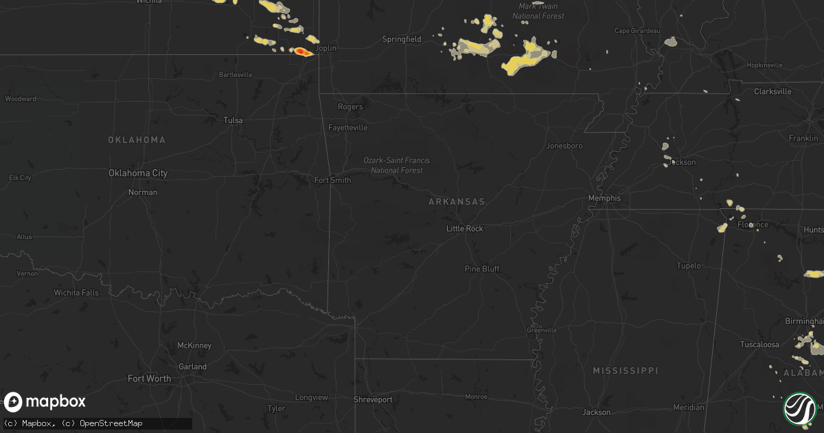
Hail Map on June 26, 2011
Get this storm
June 26 map
$229
one time, instant access
Download today. No call, no setup
Keep the $229
Bought the map and want the full workflow? Apply the entire $229 to a subscription within 7 days. None of it is wasted.
Every map, not just this one
This buys you this map. Subscription and you get every map we run, in the markets you choose from a few cities to whole states to nationwide. Plus real-time alerts the moment a storm fires.
Contact data
Name, contact info, occupancy, even credit band for addresses in the footprint. You go from where it hit to who to call.
Become the source they trust
Unlimited branding weather history reports on demand. You already have the documented answer ready for the property owner, and you are the one who showed up with it.
Property data and RoofTrace estimates
Pull up any address you have got, its value and the exact code rules for that jurisdiction, straight from One Click Code. Then RoofTrace estimates the squares, pitch, and roof value, priced the way you price.
States Impacted by Hail Map on June 26, 2011
Storm reports
North Dakota
| Date | Description |
|---|---|
| 06/26/20119:40 AM CDT | Pea to quarter sized hail lasted 5 minutes. |
| 06/25/20118:36 PM CDT | Late report. |
Tennessee
| Date | Description |
|---|---|
| 06/26/20112:05 PM CDT | A tree was knocked down onto power lines at a residence on crestview drive. |
| 06/26/20111:50 PM CDT | A couple of trees fell on a power pole. |
| 06/26/20111:30 PM CDT | Reported trees down. |
| 06/26/20111:25 PM CDT | Power lines were downed on evans road in the fivepoints area three miles north of the state line off of state route 98. |
| 06/26/20111:25 PM CDT | Several trees and construction signs were blown over. The roof of a pharmacy was damaged. Another building had part of its roof bent. |
| 06/26/20111:04 PM CDT | An eight inch tree top was broken off and fell onto a city street in lawrenceburg blocking that roadway. A 53 mph wind gust was measured at the 911 center in lawrencebu |
| 06/26/201112:30 PM CDT | Reported tree down close to proximity to home and vehicle in town center. |
Wyoming
| Date | Description |
|---|---|
| 06/25/20117:02 PM CDT | Torrington airport measured a wind gust to 60 mph. Sustained winds were recorded at 44 mph. |
Georgia
| Date | Description |
|---|---|
| 06/26/20116:55 PM CDT | A local report indicates 60 MPH wind near 1 WSW HIGH FALLS STATE |
| 06/26/20116:43 PM CDT | 8 trees down. |
| 06/26/20116:43 PM CDT | 3 tress down. |
| 06/26/20116:42 PM CDT | A few trees down. |
| 06/26/20116:36 PM CDT | Meldrim post office reported quarter size hail. |
| 06/26/20116:20 PM CDT | Two trees blown down...one taking down a power line. |
| 06/26/20116:20 PM CDT | Several trees down in mcdonough area |
| 06/26/20116:19 PM CDT | Around a half dozen trees down across the western and central portions of the county. |
| 06/26/20116:15 PM CDT | More than a dozen trees down. Details unavailble due to call volume. |
| 06/26/20116:10 PM CDT | A local report indicates 1.00 inch wind near OAKLAND |
| 06/26/20116:05 PM CDT | 9-10 trees down. |
| 06/26/20116:00 PM CDT | Numerous trees down. Additional details unavailable at time. |
| 06/26/20116:00 PM CDT | Tree down at tyrone palmetto road. |
| 06/26/20116:00 PM CDT | Barn destroyed and six trees downed. |
| 06/26/20115:56 PM CDT | Few trees down. |
| 06/26/20115:55 PM CDT | One tree down at intersection of robinson road and ebenezer road. |
| 06/26/20115:55 PM CDT | 3 trees down and one power line downed across the lagrange area |
| 06/26/20115:46 PM CDT | Hail fell for 15 to 20 minutes |
| 06/26/20115:45 PM CDT | One tree down on new port road. Knocked a power line down. |
| 06/26/20115:42 PM CDT | Several trees down in the newnan area. 20 to 30 reports received across the county. |
| 06/26/20115:40 PM CDT | Effingham county fire dept measured nickel and quarter size hail. |
| 06/26/20115:35 PM CDT | One downed tree caused damage to a house and truck. |
| 06/26/20115:35 PM CDT | Large tree down on n. Victoria rd |
| 06/26/20115:35 PM CDT | Several trees down blocking state hwy 5 towards douglas county |
| 06/26/20115:30 PM CDT | Trees down county-wide. House had water damage caused by a tree falling on its roof in camilla. |
| 06/26/20115:30 PM CDT | Large tree blocking gault rd |
| 06/26/20115:29 PM CDT | Tree fell on a house |
| 06/26/20115:26 PM CDT | Trees down across riverston parkway. One tree landed on a car. |
| 06/26/20115:24 PM CDT | Trees and power lines down on oak dale rd |
| 06/26/20115:24 PM CDT | 3 to 4 trees down in ellijay. |
| 06/26/20115:23 PM CDT | Trees down on power lines. Trees damaged a moving truck. |
| 06/26/20115:22 PM CDT | Several trees down |
| 06/26/20115:18 PM CDT | One tree down |
| 06/26/20115:17 PM CDT | One tree and one power line down. |
| 06/26/20115:15 PM CDT | Tree down on ray weaver rd. Time estimated from radar. |
| 06/26/20115:15 PM CDT | 5 trees downed by strong winds |
| 06/26/20115:10 PM CDT | Several trees down in the carrollton area. 20 trees down total across the northern 2/3rd of the county |
| 06/26/20115:08 PM CDT | 4 trees and 1 power line down. |
| 06/26/20114:55 PM CDT | 911 call center reported 2 trees down across piney bluff road in the northern portion of appling county. |
| 06/26/20114:55 PM CDT | One tree down. |
| 06/26/20114:40 PM CDT | Tree took down power lines on pine ridge drive. |
| 06/26/20114:40 PM CDT | Power lines down on rockmart road. |
| 06/26/20114:39 PM CDT | Tree and power lines down on greenridge drive. |
| 06/26/20114:35 PM CDT | Part of tin roof blown of outbuilding. |
| 06/26/20114:34 PM CDT | One tree down on ave d. |
| 06/26/20114:30 PM CDT | One tree down partially blocking the roadway on holly springs road...heading toward silver shoals road. |
| 06/26/20114:30 PM CDT | Several trees down. |
| 06/26/20114:29 PM CDT | 3 trees down. |
| 06/26/20114:29 PM CDT | Power lines down on drexsel drive. |
| 06/26/20114:22 PM CDT | Irrigation pivot overturned and knocked into road near highway 33 north. Mobile home in the same area knocked off its foundation with roof damage. |
| 06/26/20114:19 PM CDT | 1 tree down on spring creek road |
| 06/26/20114:15 PM CDT | One tree down near the intersection of coker road and race track road. |
| 06/26/20114:15 PM CDT | One tree down near the intersection of pond street and curahee road. |
| 06/26/20114:09 PM CDT | 1 tree down on highway 114 |
| 06/26/20114:05 PM CDT | A local report indicates 69 MPH wind near 2 E LYERLY |
| 06/26/20113:41 PM CDT | One tree down blocking oc banks road. |
| 06/26/20113:15 PM CDT | Tree down on ray weaver rd. Time estimated from radar. |
| 06/26/20113:08 PM CDT | A local report indicates 1.00 inch wind near 4 S REGISTER |
| 06/26/20113:00 PM CDT | Tree blown down partially blocking prospect rd |
| 06/26/201110:11 AM CDT | Public reports quarter to half dollar sized hail at the pleasant grove baptist church. |
| 06/25/20118:06 PM CDT | Local media relayed a report of one tree down along highway 261. Time estimated by radar. |
| 06/25/20117:39 PM CDT | Six to 12 trees down county wide. |
| 06/25/20117:34 PM CDT | One tree down. |
| 06/25/20117:25 PM CDT | 2 trees down near fowler field. |
| 06/25/20117:23 PM CDT | 3 trees down near winston school |
| 06/25/20117:20 PM CDT | 911 call center reported 2 trees down on powerlines. Relayed by local law enforcement. |
| 06/25/20117:20 PM CDT | 911 call center reported half dollar size to golf ball size hail northwest of jesup. Relayed by local law enforcement. |
| 06/25/20117:18 PM CDT | One tree down on cave springs rd |
| 06/25/20117:05 PM CDT | Tree down on power lines along page road. |
| 06/25/20117:02 PM CDT | Several trees down. |
| 06/25/20117:00 PM CDT | Several trees downed. 2-3 homes rcvd minor damage due to trees and limbs down. 3 power poles downed. |
South Carolina
| Date | Description |
|---|---|
| 06/26/20115:00 PM CDT | 1 foot diameter tree limb fell on a pickup truck. Picture sent in by trained spotter. |
| 06/26/20114:45 PM CDT | Large tree blown down across the road near the intersection of ritter road and bluehouse road. Time estimated based on radar. |
| 06/26/20114:42 PM CDT | Tree debris with large limbs down along exit 41 off interstate 95. |
| 06/26/20114:38 PM CDT | Several trees and large branches down near the intersection of orchard road and mewville road. |
| 06/26/20114:32 PM CDT | Tree down blocking pine grove rd |
| 06/26/20114:30 PM CDT | One small tree down at coneross campground and some campers reported awning damage. |
| 06/26/20113:41 PM CDT | One tree down along mighty cougar drive. |
| 06/26/20113:04 PM CDT | Trees down along interstate 95 near exit 59. Time estimated based on radar. |
Nebraska
| Date | Description |
|---|---|
| 06/26/20116:56 PM CDT | Hail up to ping pong ball size |
| 06/26/20116:55 PM CDT | A local report indicates 70 MPH wind near 5 W WISNER |
| 06/26/20116:48 PM CDT | Winds estimated at least 60 mph...maybe more. |
| 06/26/20116:46 PM CDT | Home damaged due to wind |
| 06/26/20116:45 PM CDT | Near highway 81 and highway 20 junction |
| 06/26/20116:45 PM CDT | Several large tree down. |
| 06/26/20116:44 PM CDT | A local report indicates 1.00 inch wind near 12 E RUSHVILLE |
| 06/26/20116:44 PM CDT | A local report indicates 2.75 inch wind near 5 NW RUSHVILLE |
| 06/26/20116:40 PM CDT | Large trees down and 6-8 inches of water over county road 519. |
| 06/26/20116:38 PM CDT | 80 mph gust from asos at norfolk airport |
| 06/26/20116:37 PM CDT | A local report indicates 1.50 inch wind near 6 N RUSHVILLE |
| 06/26/20116:35 PM CDT | A local report indicates 70 MPH wind near 1 W NORFOLK |
| 06/26/20116:35 PM CDT | 57 kt gust from asos at norfolk airport |
| 06/26/20116:35 PM CDT | 4 to 6 inch limbs blown down |
| 06/26/20116:25 PM CDT | 4 inch diameter branches down. Wind estimated up to 70 mph. |
| 06/26/20116:20 PM CDT | Hail up to quarter size |
| 06/26/20116:11 PM CDT | A local report indicates 1.75 inch wind near 17 N HAY SPRINGS |
| 06/26/20116:05 PM CDT | A local report indicates 60 MPH wind near NELIGH |
| 06/26/20116:05 PM CDT | Also 30-40 mph winds and 0.76 inches of rain |
| 06/26/20115:45 PM CDT | A local report indicates 1.00 inch wind near 1 N ROYAL |
| 06/26/20115:45 PM CDT | Torrential rain with 50 to 60 mph winds. |
| 06/26/20115:40 PM CDT | Mostly dime sized hail lasted for 5 minutes. |
| 06/26/20115:40 PM CDT | A local report indicates 60 MPH wind near 10 SE BARTLETT |
| 06/26/20115:35 PM CDT | Estimated 60 to 70 mph wind gusts along with pebble sized hail and very heavy rain. |
| 06/26/20115:15 PM CDT | Herdco feed lot reported very strong winds along with hail as large as golf balls. |
| 06/26/20115:15 PM CDT | Mostly nickel sized hail but some hail was as large as golfballs. Report was furnished by herdco feed lot. |
| 06/26/20114:28 PM CDT | A local report indicates 2.75 inch wind near 8 WSW AMELIA |
| 06/26/20114:23 PM CDT | Spotter estimated 60 to 70 mph winds 6 miles south of atkinson. |
| 06/26/20113:05 PM CDT | Hail and high winds from 305 pm to 325 pm cdt caused crop and pasture damage at this location. Report was furnished by an nerain observer. |
| 06/26/20113:05 PM CDT | A local report indicates 1.75 inch wind near 9 ENE ELSMERE |
| 06/26/20112:53 PM CDT | A local report indicates 1.00 inch wind near 12 S WOOD LAKE |
| 06/26/20112:53 PM CDT | Wind speeds of 60 mph occurring along with nickel to quarter sized hail at time of this report. |
| 06/26/20112:20 PM CDT | Public reported wind gust to 60 mph. Measured with home weather station. |
| 06/26/20112:10 PM CDT | 6 rural electric associaton power poles were blown down one half mile west of the valentine national wildlife refuge headquarters building. Time of damage estimated at |
| 06/26/20111:56 PM CDT | Public reported cracked windshields and plastic parts damage. |
| 06/26/20111:56 PM CDT | Reported by merritt trading post at merritt dam |
| 06/26/201110:11 AM CDT | Some marble sized also. |
| 06/26/201110:10 AM CDT | Hail broke out window in house |
| 06/26/20112:15 AM CDT | A local report indicates 1.00 inch wind near NEHAWKA |
| 06/26/20111:45 AM CDT | A local report indicates 1.00 inch wind near 3 SSW LINCOLN |
| 06/26/201112:45 AM CDT | A local report indicates 1.00 inch wind near FULLERTON |
| 06/26/201112:00 AM CDT | Windows blown out at the caseys gas station in town |
| 06/25/201111:59 PM CDT | A local report indicates 1.00 inch wind near 6 E ORD |
| 06/25/201111:57 PM CDT | A local report indicates 1.00 inch wind near NORTH PLATTE |
| 06/25/201111:54 PM CDT | A local report indicates 1.00 inch wind near 3 E ORD |
| 06/25/201111:41 PM CDT | A local report indicates 1.75 inch wind near HERSHEY |
| 06/25/201111:36 PM CDT | A local report indicates 1.00 inch wind near HERSHEY |
| 06/25/201111:36 PM CDT | Reported from knop tv. |
| 06/25/201111:00 PM CDT | A local report indicates 1.50 inch wind near 4 S DAWSON |
| 06/25/201111:00 PM CDT | Tree down across hwy 75 1/2 mile south of hwy 8 intersection. |
| 06/25/201110:35 PM CDT | A local report indicates 1.00 inch wind near HUMBOLDT |
| 06/25/201110:26 PM CDT | A local report indicates 1.00 inch wind near PAWNEE CITY |
| 06/25/201110:11 PM CDT | A local report indicates 2.00 inch wind near 2 E BURCHARD |
| 06/25/201110:10 PM CDT | Tree branches down up to 5 inches in diameter. Power outages in tecumseh. |
| 06/25/201110:10 PM CDT | 2 large trees uprooted. Small 10 x 10 garage demolished. |
| 06/25/201110:10 PM CDT | A local report indicates 1.00 inch wind near THEDFORD |
| 06/25/20119:58 PM CDT | A local report indicates 1.50 inch wind near STEINAUER |
| 06/25/20119:47 PM CDT | A local report indicates 1.00 inch wind near MULLEN |
| 06/25/20119:40 PM CDT | A local report indicates 1.00 inch wind near STERLING |
| 06/25/20119:36 PM CDT | A local report indicates 1.00 inch wind near 6 NNE MULLEN |
| 06/25/20119:25 PM CDT | A local report indicates 1.75 inch wind near 18 SSW HYANNIS |
| 06/25/20118:57 PM CDT | A local report indicates 1.75 inch wind near 47 S MERRIMAN |
| 06/25/20118:56 PM CDT | A local report indicates 1.00 inch wind near 47 S MERRIMAN |
| 06/25/20118:44 PM CDT | A local report indicates 1.25 inch wind near CRETE |
| 06/25/20118:40 PM CDT | 54th and knox st. |
| 06/25/20118:40 PM CDT | Most of the stones were much smaller. |
| 06/25/20118:38 PM CDT | A local report indicates 1.00 inch wind near LINCOLN |
| 06/25/20118:38 PM CDT | Tree down at 48th and holdridge |
| 06/25/20118:37 PM CDT | Quarter size hail continues. |
| 06/25/20118:36 PM CDT | A local report indicates 1.75 inch wind near LINCOLN |
| 06/25/20118:33 PM CDT | Small hail lasted from 733 pm until 743 pm mdt. The largest stones were up to walnut size. Estimated wind gusts of at least 40 mph preceded the rain and hail. |
| 06/25/20118:18 PM CDT | A local report indicates 1.00 inch wind near 3 SE GARLAND |
| 06/25/20118:11 PM CDT | Wind gust of 60 mph |
| 06/25/20117:50 PM CDT | Estimated 50 to 60 mph wind gusts preceded the storm. Nickle sized hail was observed at 702 pm mdt. |
| 06/25/20117:50 PM CDT | Numerous 4 to 6 inch diameter branches downed. |
| 06/25/20117:43 PM CDT | A local report indicates 69 MPH wind near TEKAMAH |
| 06/25/20117:40 PM CDT | A local report indicates 1.25 inch wind near 32 SSW MERRIMAN |
| 06/25/20117:40 PM CDT | A local report indicates 1.00 inch wind near 41 S MERRIMAN |
| 06/25/20117:35 PM CDT | Lots of blowing dust. |
| 06/25/20117:23 PM CDT | Numerous 4 to 6 inch diameter branches downed. |
| 06/25/20117:12 PM CDT | Small branches blown down |
| 06/25/20117:03 PM CDT | Tree damage including large branches blown down. |
Alabama
| Date | Description |
|---|---|
| 06/26/20116:34 PM CDT | Trees down across the city of opelika...numerous locations. |
| 06/26/20115:44 PM CDT | Trees down around town. |
| 06/26/20115:20 PM CDT | Trees down in several locations in the city of valley |
| 06/26/20114:57 PM CDT | Trees down at the intersection of narrows parkway and old highway 280. |
| 06/26/20114:51 PM CDT | Trees down at the intersection of highway 25 and county road 305. |
| 06/26/20114:30 PM CDT | Quarter size hail reported. |
| 06/26/20114:29 PM CDT | Quarter size hail in the city of chelsea. |
| 06/26/20114:28 PM CDT | Power lines down in the city of talladega. |
| 06/26/20114:20 PM CDT | Power line down and smoking. |
| 06/26/20114:20 PM CDT | Tree down across highway 68 east near county road 151. |
| 06/26/20114:16 PM CDT | Tree down across highway 35. |
| 06/26/20114:10 PM CDT | Shingles off a roof and tree limbs down. |
| 06/26/20114:10 PM CDT | Marble to quarter size hail. |
| 06/26/20114:10 PM CDT | Powerlines down on lakeshore just west of green springs highway. |
| 06/26/20114:09 PM CDT | Tree down across highway 68 east and highway 176 in sand rock. |
| 06/26/20113:59 PM CDT | Tree down across county road 131 in cedar bluff. |
| 06/26/20113:55 PM CDT | Trees and power lines down at county road 75 and 144 in cedar bluff. |
| 06/26/20113:55 PM CDT | A local report indicates 60 MPH wind near CEDAR BLUFF |
| 06/26/20113:48 PM CDT | Tree down at gallant road and country hill road in gallant. |
| 06/26/20113:42 PM CDT | Tree down at gallant road and country hill road in gallant. |
| 06/26/20113:38 PM CDT | Trees down |
| 06/26/20113:30 PM CDT | Tree down on broadway street in sardis city. |
| 06/26/20113:30 PM CDT | Emergency manager reports several trees and power lines down in the northern and western parts of the county. |
| 06/26/20113:28 PM CDT | Small broken tree limbs |
| 06/26/20113:20 PM CDT | Barn destroyed and blown into the road at the 6400 block of county road 436. |
| 06/26/20113:20 PM CDT | Tree on a house on the 300 block of county road 336. |
| 06/26/20113:14 PM CDT | Trees down in saragossa. |
| 06/26/20113:10 PM CDT | Canopy was ripped and destroyed from homeowners backyard in jasper. |
| 06/26/20113:00 PM CDT | Trees down |
| 06/26/20113:00 PM CDT | Trees down |
| 06/26/20113:00 PM CDT | Trees down |
| 06/26/20112:32 PM CDT | Broken limbs and trees down |
| 06/26/20112:32 PM CDT | Broken limbs and trees down |
| 06/26/20112:30 PM CDT | Trees were knocked down onto county road 59. Time and location estimated. Power outages in the area. |
| 06/26/20112:30 PM CDT | Trees down. Downed tree and power line pole blocking road. |
| 06/26/20112:30 PM CDT | Trees were knocked down onto county road 184. Time and location estimated. |
| 06/26/20112:28 PM CDT | Trees were knocked down onto county road 334. Time and location estimated. |
| 06/26/20112:28 PM CDT | Trees down |
| 06/26/20112:28 PM CDT | Trees down |
| 06/26/20112:28 PM CDT | Trees down |
| 06/26/20112:25 PM CDT | Trees were knocked down onto county road 87. Time and location estimated. |
| 06/26/20112:25 PM CDT | Trees were knocked down onto county road 81. Time and location estimated. Power outages in the area. |
| 06/26/20112:23 PM CDT | Trees were knocked onto power lines along county road 221. Time and location estimated. |
| 06/26/20112:20 PM CDT | Trees were knocked down onto county road 75. Time and location estimated. Power outages in the area. |
| 06/26/20112:20 PM CDT | Trees were knocked down along state highway 243. Time and location estimated. Power outages in the area. |
| 06/26/20112:15 PM CDT | Trees on power lines |
| 06/26/20112:15 PM CDT | Power outages due to trees on power lines |
| 06/26/20112:15 PM CDT | Power outages due to trees on power lines |
| 06/26/20112:15 PM CDT | Power outages due to trees on power lines |
| 06/26/20112:15 PM CDT | Trees were knocked down onto county road 175. Time and location estimated. Power outages in the area. |
| 06/26/20112:15 PM CDT | Trees on power lines |
| 06/26/20112:14 PM CDT | Trees down in saragossa. |
| 06/26/20112:10 PM CDT | Snapped power pole |
| 06/26/20112:06 PM CDT | Tree down |
| 06/26/20111:55 PM CDT | Trees were knocked down onto cottontown hill road. Time and location estimated. |
| 06/26/20111:50 PM CDT | Trees were knocked down onto mount hester road. Time and location estimated. |
| 06/26/20111:50 PM CDT | Trees were knocked down onto river rose trail. Time and location estimated. |
| 06/26/20111:45 PM CDT | Trees were knocked down on henry road. Time and location estimated. |
Kansas
| Date | Description |
|---|---|
| 06/26/201111:50 AM CDT | A local report indicates 1.00 inch wind near 1 S SKIDMORE |
| 06/26/201111:20 AM CDT | Delayed report. Multiple large trees and limbs down. Damage to a few metal structures with one outbuilding destroyed. |
| 06/26/201110:59 AM CDT | Baxter springs fire chief reported windshield broken at the intersection of highway 166 and highway 69. |
| 06/26/201110:43 AM CDT | A local report indicates 1.00 inch wind near 6 WNW ERIE |
| 06/26/201110:40 AM CDT | A local report indicates 1.25 inch wind near 3 W MELROSE |
| 06/26/201110:28 AM CDT | A local report indicates 1.25 inch wind near CHANUTE |
| 06/26/201110:26 AM CDT | A local report indicates 1.25 inch wind near CHANUTE |
| 06/26/201110:09 AM CDT | A local report indicates 1.00 inch wind near 1 E SHERMAN |
| 06/26/20119:40 AM CDT | A local report indicates 1.00 inch wind near PARSONS |
| 06/26/20119:34 AM CDT | 30 to 40 mph wind gusts. |
| 06/26/20116:08 AM CDT | A local report indicates 1.00 inch wind near HOLTON |
| 06/26/20113:00 AM CDT | Received 0.90 inches of rainfall. Estimated time of report from radar data. |
| 06/26/20111:41 AM CDT | A local report indicates 1.50 inch wind near 10 ESE BENKELMAN |
| 06/26/20111:32 AM CDT | A local report indicates 1.00 inch wind near 4 S TOPEKA |
| 06/26/20111:27 AM CDT | A local report indicates 1.00 inch wind near 5 N PERRY |
| 06/26/20111:10 AM CDT | A local report indicates 1.25 inch wind near 3 S ROSSVILLE |
| 06/26/201112:56 AM CDT | A local report indicates 1.00 inch wind near BELVUE |
| 06/26/201112:47 AM CDT | A local report indicates 1.00 inch wind near 3 N WAMEGO |
| 06/26/201112:45 AM CDT | A local report indicates 1.00 inch wind near LOUISVILLE |
| 06/26/201112:40 AM CDT | A local report indicates 1.00 inch wind near WAMEGO |
| 06/25/201111:50 PM CDT | Tennis ball sized hail reported on highway 36 one mile east of highland. |
| 06/25/201111:35 PM CDT | A local report indicates 1.00 inch wind near 8 NNE ROBINSON |
| 06/25/201111:30 PM CDT | A local report indicates 1.00 inch wind near 3 N HIAWATHA |
Minnesota
| Date | Description |
|---|---|
| 06/26/20115:30 AM CDT | A local report indicates 1.00 inch wind near 1 W PARKERS PRAIRIE |
Illinois
| Date | Description |
|---|---|
| 06/26/20114:27 AM CDT | Tree down near intersection of us-40 and county road 1000e. |
| 06/26/20113:28 AM CDT | A local report indicates 62 MPH wind near 3 SSE EAST PEORIA |
| 06/26/20112:55 AM CDT | Delayed report. Trees down in town. Time estimated. |
| 06/26/20112:53 AM CDT | Tree split in two...landing on power lines |
| 06/26/20112:52 AM CDT | A local report indicates 60 MPH wind near LITTLE AMERICA |
| 06/26/20112:45 AM CDT | Observer is seeing power flashes |
| 06/26/20112:30 AM CDT | Relayed from isp scanner traffic...power poles down south of jerseyville on us hwy 67 near crystal lake road |
| 06/26/20112:30 AM CDT | Mobile home walls blown down and out. Trees and powerlines down. |
| 06/26/20112:30 AM CDT | Several fir trees blown down in macomb. Delayed report. |
| 06/26/20112:20 AM CDT | 18 inch diameter tree snapped off at base...downed powerlines and power out in town of colchester. |
| 06/26/20112:15 AM CDT | 20 inch diameter trunk/18 foot tall tree uprooted in colchester. Time estimated on delayed report. |
| 06/26/20112:05 AM CDT | One foot diameter tree limb blown out of a large pecan tree. |
| 06/26/20111:46 AM CDT | Estimated 65 to 70 mph wind. Power is out in bowen and also in augusta. Time was estimated. |
| 06/26/20111:46 AM CDT | Numerous trees and power lines down. Time of damage estimated. |
| 06/26/20111:45 AM CDT | Several trees and limbs blown down. |
| 06/26/20111:45 AM CDT | Numerous trees and power lines downed. |
| 06/26/20111:45 AM CDT | Some buildings blown down between carthage and bentley. Second hand report. Time estimated. |
| 06/26/20111:45 AM CDT | Winds in excess of 70 mph blew down several trees and large limbs in bentley. Some roads were blocked. Some buildings and homes were also damaged. A new morton building |
| 06/26/20111:44 AM CDT | Also observing powerline flashes on east side of carthage. |
| 06/26/20111:43 AM CDT | Estimated 60-70 mph wind gusts |
| 06/26/20111:41 AM CDT | 8-12 inch tree limbs down |
| 06/26/20111:38 AM CDT | A local report indicates 1.00 inch wind near WARSAW |
| 06/26/20111:38 AM CDT | Tree limbs and powerlines down. |
| 06/26/20111:37 AM CDT | 60-70 mph estimated wind gusts...power is out. |
| 06/26/20111:36 AM CDT | Estimated 60-70 mph wind gusts |
| 06/26/20111:35 AM CDT | Trees and tree limbs down...pine tree snapped |
| 06/26/20111:35 AM CDT | A local report indicates 76 MPH wind near 4 NE BURTON |
| 06/26/20111:35 AM CDT | Numerous trees down in town...power out |
| 06/26/20111:33 AM CDT | A local report indicates 80 MPH wind near PAYSON |
| 06/26/20111:30 AM CDT | 60-70 mph estimated wind gusts...power is out. |
| 06/26/20111:30 AM CDT | 8-12 inch tree limbs down |
| 06/26/20111:25 AM CDT | Several trees downed and power out |
| 06/26/201112:05 AM CDT | A local report indicates 1.75 inch wind near 1 S LATHAM |
| 06/26/201112:05 AM CDT | A local report indicates 60 MPH wind near 1 S LATHAM |
| 06/25/201111:35 PM CDT | Hail fell for 5 minutes |
| 06/25/201111:06 PM CDT | A local report indicates 61 MPH wind near 5 SW PEORIA |
| 06/25/201110:42 PM CDT | Small tree brancehs down. Corn stalks snapped near the ground. |
South Dakota
| Date | Description |
|---|---|
| 06/26/20116:50 PM CDT | A local report indicates 65 MPH wind near 7 SSW DOWNTOWN HOT SPRI |
| 06/26/20116:30 PM CDT | A local report indicates 60 MPH wind near 1 E PROVO |
| 06/26/20115:35 PM CDT | A local report indicates 1.75 inch wind near 11 SSE OELRICHS |
| 06/26/20115:20 PM CDT | Also had 50 mph winds |
| 06/26/20114:45 PM CDT | A local report indicates 1.00 inch wind near 15 NNE CREIGHTON |
| 06/26/20114:30 PM CDT | A local report indicates 70 MPH wind near 4 S WASTA |
| 06/26/20114:30 PM CDT | 70 mph wind gusts |
| 06/26/20113:45 PM CDT | A local report indicates 1.00 inch wind near 5 WSW OELRICHS |
| 06/26/20113:44 PM CDT | A local report indicates 1.75 inch wind near RAPID VALLEY |
| 06/26/20112:33 PM CDT | A local report indicates 1.00 inch wind near 19 ESE HERMOSA |
| 06/26/201110:43 AM CDT | A local report indicates 73 MPH wind near 1 N BUFFALO |
| 06/26/20119:48 AM CDT | A local report indicates 60 MPH wind near 1 N ROCKYFORD |
| 06/26/20119:48 AM CDT | A local report indicates 1.00 inch wind near 1 N ROCKYFORD |
Florida
| Date | Description |
|---|---|
| 06/26/20115:00 PM CDT | Pine trees snapped off and damage to structures near county road 417 and interstate 10. |
| 06/26/20114:45 PM CDT | 911 call center reports 5 trees down on powerlines on state road 121 and lake hampton road northwest of hilliard. Time is estimated based on radar imagery. |
| 06/26/20114:40 PM CDT | Quarter size hail and estimated wind gust to 50 mph |
| 06/26/20114:30 PM CDT | 911 call center reported several trees down in the western portion of the county near jasper. Time is estimated and based on radar imagery. |
| 06/26/20114:02 PM CDT | Quarter size hail and estimated 45 mph winds. |
| 06/26/20113:42 PM CDT | 911 call center reported several trees down in the eastern portions of the county. Time is estimated and based on radar imagery. |
| 06/26/20113:20 PM CDT | Numerous trees down across the city of tallahassee including on centerville road...chaires road...buck lake road...and old bainbridge road. |
| 06/26/20113:15 PM CDT | 4 wsw holly hill tree down at intersection of lpga williamson blvds. Estimated tree size 8-12 inches blocking 1 west bound lane on lpga blvd. |
| 06/26/20113:05 PM CDT | Tree limbs down and nickel size hail. |
Missouri
| Date | Description |
|---|---|
| 06/26/20114:53 PM CDT | Shreading leaves off of trees. Also rotating wall cloud passed directly overhead. This is second round of large hail spotter has received |
| 06/26/20114:40 PM CDT | Trees reported down in the community. |
| 06/26/20114:33 PM CDT | A local report indicates 1.00 inch wind near BLACKWELL |
| 06/26/20114:32 PM CDT | A local report indicates 1.50 inch wind near CADET |
| 06/26/20114:19 PM CDT | A local report indicates 60 MPH wind near 4 ENE OLD MINES |
| 06/26/20114:15 PM CDT | A local report indicates 1.75 inch wind near 4 ENE OLD MINES |
| 06/26/20113:11 PM CDT | A local report indicates 1.00 inch wind near 2 N PRESCOTT |
| 06/26/20113:05 PM CDT | Mixed quarter and half dollar sized hail reported. Lightly covering groud. |
| 06/26/20112:40 PM CDT | A local report indicates 1.00 inch wind near CABOOL |
| 06/26/20112:39 PM CDT | One inch hail reported at route 60 and route 181 intersection. |
| 06/26/20112:35 PM CDT | One barn destroyed and power lines down. |
| 06/26/20112:05 PM CDT | A local report indicates 1.00 inch wind near NORWOOD |
| 06/26/201111:30 AM CDT | Tree blocking us highway 65. |
| 06/26/20115:35 AM CDT | Large tree down on home at 35th and woodland |
| 06/26/20115:30 AM CDT | Tree fell onto a home. Numerous large limbs down. |
| 06/26/20115:15 AM CDT | Multiple large tree limbs down near n indiana and ne antioch rd. Estimated gust 60 mph. |
| 06/26/20112:42 AM CDT | A local report indicates 1.00 inch wind near GRAY SUMMIT |
| 06/26/20112:42 AM CDT | A local report indicates 65 MPH wind near GRAY SUMMIT |
| 06/26/20112:39 AM CDT | A local report indicates 63 MPH wind near 4 SW FENTON |
| 06/26/20112:33 AM CDT | A local report indicates 65 MPH wind near DRAKE |
| 06/26/20112:32 AM CDT | Up to 3 inch diameter branches snapped off trees. Large trash dumpsters blown out onto the streets. |
| 06/26/20112:25 AM CDT | A local report indicates 1.50 inch wind near CARROLLTON |
| 06/26/20112:22 AM CDT | A local report indicates 65 MPH wind near DRAKE |
| 06/26/20112:16 AM CDT | A local report indicates 70 MPH wind near NEW HAVEN |
| 06/26/20112:15 AM CDT | Up to 3 inch diameter branches snapped off trees. Large trash dumpsters blown out onto the streets. |
| 06/26/20112:00 AM CDT | Power lines down...wright city also |
| 06/26/20112:00 AM CDT | A large tree was blown over onto a car on roosevelt avenue. |
| 06/26/20111:30 AM CDT | Large tree damage reported all across the northern half of the county |
| 06/26/20111:30 AM CDT | Trees damaged and uprooted. Time estimated from radar. |
| 06/26/20111:30 AM CDT | Dime size hail...across the road from the airport |
| 06/26/20111:30 AM CDT | A local report indicates 80 MPH wind near 6 NW NEW HARTFORD |
| 06/26/20111:28 AM CDT | A local report indicates 62 MPH wind near 4 NNE ASHLAND |
| 06/26/20111:28 AM CDT | Several trees blown down. One tree was blocking log providence road north of ashland. |
| 06/26/20111:27 AM CDT | A local report indicates 61 MPH wind near 3 WNW HANNIBAL |
| 06/26/20111:25 AM CDT | Several large trees blown down in town. |
| 06/26/20111:20 AM CDT | Measured at lock and dam 20 |
| 06/26/20111:15 AM CDT | Several trees uprooted as well |
| 06/26/20111:14 AM CDT | Several trees blown down on west side of town. |
| 06/26/20111:14 AM CDT | Roof partially blown off of a building near potterfield trucking on u.s. Highway 24 36 east. |
| 06/26/20111:07 AM CDT | 5-6 inch limbs down...quarter sized hail. |
| 06/26/20111:07 AM CDT | 5-6 inch limbs down...quarter sized hail. |
| 06/26/20111:07 AM CDT | Heavy rain is occurring with the hail. |
| 06/26/20111:03 AM CDT | Estimated 50-60 wind gusts...power is out as well. |
| 06/26/20111:00 AM CDT | Several trees blown down in northwestern portions of county. |
| 06/26/201112:55 AM CDT | Three to five trees blown down in yard. One tree was at least 10 inches in diameter. |
| 06/26/201112:55 AM CDT | Two to three foot diameter trees uprooted in town...one two and a half foot diameter tree snapped off at base. |
| 06/26/201112:55 AM CDT | Damage reported all across lewis county...large trees down...power lines down...several mobile homes destroyed...other structural damage countywide. |
| 06/26/201112:46 AM CDT | Thunderstorm wind gusts estimated up to 70 mph. Many tree branches down. Swing set blown over. |
| 06/26/201112:45 AM CDT | Small building 15 ft up into a tree. 5 rec vehicles overturned. |
| 06/26/201112:45 AM CDT | Trees...tree limbs and power lines down throughout town...from chiel of police |
| 06/26/201112:45 AM CDT | Part of roof blown off a house and shingles and sheeting blown off. |
| 06/26/201112:43 AM CDT | 3 ft diameter trees uprooted power lines down |
| 06/26/201112:40 AM CDT | Up to three foot diameter trees downed |
| 06/26/201112:38 AM CDT | Thunderstorm wind gusts estimated up to 70 mph. Electricity is out and branches are blown down. |
| 06/26/201112:30 AM CDT | Trees down in town. Time estimated. |
| 06/26/201112:27 AM CDT | Trees and power lines down countywide...between 1227 am and 1 am. |
| 06/26/201112:26 AM CDT | Thunderstorm wind gusts estimated up to 70 mph. Also reported nickel sized hail. |
| 06/26/201112:22 AM CDT | Estimated gusts to 60 mph. |
| 06/26/201112:20 AM CDT | Car port damaged and multiple trees blown down. |
| 06/26/201112:19 AM CDT | Possible funnel cloud also spotted at this location. |
| 06/26/201112:19 AM CDT | Multiple reports of power lines down. |
| 06/26/201112:15 AM CDT | Power poles blown down. Time estimated. |
| 06/26/201112:10 AM CDT | A local report indicates 70 MPH wind near KIRKSVILLE |
| 06/26/201112:08 AM CDT | A local report indicates 71 MPH wind near MILAN |
| 06/26/201112:01 AM CDT | Emergency manager reports at cameron memorial airport wind damage of tied down airplane flipped over. Numerous untied airplanes moved around no damage. Rainfall amount |
| 06/25/201111:55 PM CDT | Numerous power lines down |
| 06/25/201111:55 PM CDT | A local report indicates 70 MPH wind near 4 W NOVINGER |
| 06/25/201111:54 PM CDT | A local report indicates 71 MPH wind near MILAN |
| 06/25/201111:52 PM CDT | A local report indicates 60 MPH wind near BRAYMER |
| 06/25/201111:50 PM CDT | A local report indicates 70 MPH wind near 1 SSW LAREDO |
| 06/25/201111:47 PM CDT | Large tree down |
| 06/25/201111:45 PM CDT | Large tree fell and caused gas leak. |
| 06/25/201111:41 PM CDT | Numerous trees down in gallatin. Power is out. |
| 06/25/201111:36 PM CDT | Trees and power lines down on tindall ave in trenton. |
| 06/25/201111:30 PM CDT | Tree blocking us highway 65. |
| 06/25/201111:25 PM CDT | Very heavy rain and pea-sized hail as well. |
| 06/25/201111:20 PM CDT | Large tree limb down. Power out in mill grove. |
| 06/25/201111:12 PM CDT | 60 mph wind speed...estimated. |
| 06/25/201111:12 PM CDT | A local report indicates 1.00 inch wind near KING CITY |
| 06/25/201111:12 PM CDT | Power lines blown down in bethany. Time estimated. |
| 06/25/201111:10 PM CDT | Large tree limbs down. |
| 06/25/201111:01 PM CDT | Large hail falling concurrent with 60 to 65 mph winds. |
| 06/25/201111:00 PM CDT | Trees and power lines down. |
| 06/25/201111:00 PM CDT | Power lines down |
| 06/25/201111:00 PM CDT | Trees and power lines down. |
| 06/25/201110:58 PM CDT | 60 to 65 mph wind speed estimated. |
| 06/25/201110:55 PM CDT | Numerous branches down with thunderstorm wind gusts to 60 mph. |
| 06/25/201110:55 PM CDT | Tree limbs and power lines down. |
| 06/25/201110:52 PM CDT | 30 foot metal horse trailer blown over on its side. Numerous large tree limbs down. Thunderstorm wind gusts were estimated to 60 mph. |
| 06/25/201110:42 PM CDT | 6-10 inch tree limbs down at the intersection of hwy 129 and cc |
| 06/25/201110:31 PM CDT | Tree blown down on car. Time estimated. |
| 06/25/201110:31 PM CDT | Also dime size hail. |
| 06/25/201110:19 PM CDT | Two to three inch tree limbs reported down with power outages in town. |
| 06/25/201110:19 PM CDT | One large tree fell down on power line. Power out in town. Several large tree limbs also knocked down. Thunderstorm wind gusts estimated up to 60 mph. |
| 06/25/201110:15 PM CDT | Tree blown down. Time estimated. |
| 06/25/20119:30 PM CDT | Quarter size hail just west southwest of monticello on highway 16 |
| 06/25/20118:47 PM CDT | Pea to quarter size hail and one inch of rain with the storm. |
| 06/25/20117:52 PM CDT | A local report indicates 1.75 inch wind near 5 E QUITMAN |
| 06/25/20117:50 PM CDT | Media reports brief spin up with light debris. |
| 06/25/20117:40 PM CDT | A local report indicates 1.25 inch wind near 5 E QUITMAN |
North Carolina
| Date | Description |
|---|---|
| 06/26/20116:26 PM CDT | Several trees down |
| 06/25/20117:20 PM CDT | Multiple trees reported down in the forest city area. Trees also reported down on either side of hwy 221 south of rutherfordton. Time estimated from radar. |
Iowa
| Date | Description |
|---|---|
| 06/26/20116:49 PM CDT | A local report indicates 60 MPH wind near CENTERVILLE |
| 06/26/20116:23 PM CDT | A local report indicates 1.00 inch wind near CENTERVILLE |
| 06/26/20116:22 PM CDT | Nickel to quarter sized hail covering parking lot. |
| 06/26/20116:21 PM CDT | Quarter to golf ball sized hail. |
| 06/26/20116:12 PM CDT | 3 to 4 inch tree branches down with pea size hail. |
| 06/26/20116:04 PM CDT | Electric pole partially blown over...wires sparking |
| 06/26/20116:00 PM CDT | Nickel to quarter hail relayed to law enforcement from public. |
| 06/26/20115:55 PM CDT | A local report indicates 1.00 inch wind near 3 S WOODBURN |
| 06/26/20115:25 PM CDT | A local report indicates 1.00 inch wind near CHARITON |
| 06/26/20114:55 PM CDT | A local report indicates 1.00 inch wind near 3 N CRESTON AIRPORT |
| 06/26/20117:46 AM CDT | At least six homes with roof damage with shingles blown off. Power lines downed. Grain bin destroyed in the outskirts of town. |
| 06/26/20111:32 AM CDT | Trees down in town. |
| 06/26/20111:15 AM CDT | Several trees were uprooted or snapped near the base. The pallet building on johnson street collapsed. The redemption center building on s 4th and johnson street collap |
| 06/25/201111:25 PM CDT | A local report indicates 60 MPH wind near E OTTUMWA |
| 06/25/201111:15 PM CDT | Time estimated |
| 06/25/201111:06 PM CDT | From kboe radio station reported by weather eye |
| 06/25/201111:00 PM CDT | A local report indicates 2.00 inch wind near CINCINNATI |
| 06/25/201110:52 PM CDT | Large tree blown down and cable wires hanging low. |
| 06/25/201110:40 PM CDT | A local report indicates 77 MPH wind near PELLA |
| 06/25/201110:38 PM CDT | A local report indicates 73 MPH wind near PELLA |
| 06/25/201110:35 PM CDT | Tree down in knoxville town square |
| 06/25/201110:34 PM CDT | Powerline and poles down |
| 06/25/201110:31 PM CDT | A local report indicates 62 MPH wind near KNOXVILLE |
| 06/25/201110:15 PM CDT | Tree branches down as well. |
| 06/25/201110:06 PM CDT | A local report indicates 58 MPH wind near DES MOINES INT AIRPORT |
| 06/25/201110:05 PM CDT | A local report indicates 70 MPH wind near NORWALK |
| 06/25/201110:05 PM CDT | A local report indicates 1.00 inch wind near CRESTON |
| 06/25/20119:52 PM CDT | Large tree limbs down and torrential rains. |
| 06/25/20119:52 PM CDT | Measured at the kcci studios |
| 06/25/20119:52 PM CDT | 3 inch diameter tree branches down. |
| 06/25/20119:50 PM CDT | Estimated 65 mph winds. 3-6 inch diameter tree branches down |
| 06/25/20119:47 PM CDT | A local report indicates 63 MPH wind near 5 WNW DES MOINES |
| 06/25/20119:45 PM CDT | Semi blown over near hw 30 in carroll |
| 06/25/20119:40 PM CDT | Three branch down in stuart blocking street and it hit a car. |
| 06/25/20119:38 PM CDT | Estimated wind speed. Could not check for damage |
| 06/25/20119:35 PM CDT | Heavy rain. Estimated 40 mph winds |
| 06/25/20119:35 PM CDT | Pea hail |
| 06/25/20119:30 PM CDT | Semi trailer overturned on highway 141 |
| 06/25/20119:30 PM CDT | Six inch diameter branch down. Patio furniture blown throughout yard. Loss of power for five minutes. |
| 06/25/20119:30 PM CDT | Six inch tree limbs down in adel. |
| 06/25/20119:29 PM CDT | Large 2 to 3 foot diameter oak tree down. |
| 06/25/20119:27 PM CDT | Measured at the perry airport |
| 06/25/20119:26 PM CDT | A local report indicates 60 MPH wind near 3 W ADEL |
| 06/25/20119:24 PM CDT | 24 inch wide tree down in stuart |
| 06/25/20119:20 PM CDT | A local report indicates 60 MPH wind near 3 ESE MALVERN |
| 06/25/20119:11 PM CDT | A local report indicates 60 MPH wind near ADAIR |
| 06/25/20119:10 PM CDT | Trees and power lines down |
| 06/25/20119:00 PM CDT | Power out throughout west side of fort madison. |
| 06/25/20119:00 PM CDT | 3 to 4 inch tree branches down. |
| 06/25/20118:55 PM CDT | Large tree limbs down. Nickle hail |
| 06/25/20118:54 PM CDT | A local report indicates 60 MPH wind near OAKLAND |
| 06/25/20118:51 PM CDT | A local report indicates 1.00 inch wind near 1 SE AUDUBON |
| 06/25/20118:45 PM CDT | 8 inch diameter tree limbs down. Time estimated from radar |
| 06/25/20118:43 PM CDT | A local report indicates 60 MPH wind near CARROLL |
| 06/25/20118:41 PM CDT | A local report indicates 1.75 inch wind near GLENWOOD |
| 06/25/20118:40 PM CDT | Possible tornado...storm survey in progress. |
| 06/25/20118:40 PM CDT | Ef1 tornado on the ground for 1 minute. Length 2.5 miles due east with a width of 50 yards. The roof was blown off a hog confinement building and a morton building with |
| 06/25/20118:35 PM CDT | No damage noted at this area from the winds but it was noted that some trees were downed a little west of this location when driving through after the storm. |
| 06/25/20118:35 PM CDT | Measured by the harlan awos khnr. |
| 06/25/20118:34 PM CDT | A local report indicates 60 MPH wind near ODEBOLT |
| 06/25/20118:34 PM CDT | Trees down and street flooding. |
| 06/25/20118:33 PM CDT | Trees down in denison and 2 miles west of town |
| 06/25/20118:32 PM CDT | A local report indicates 60 MPH wind near IRWIN |
| 06/25/20118:30 PM CDT | 1-2 diameter branches down due to strong winds |
| 06/25/20118:30 PM CDT | Power lines down |
| 06/25/20118:28 PM CDT | A local report indicates 60 MPH wind near HARLAN |
| 06/25/20118:25 PM CDT | Hail ended at 825 pm |
| 06/25/20118:25 PM CDT | Tree down on mobile home |
| 06/25/20118:15 PM CDT | Numerous tree branches down |
| 06/25/20118:15 PM CDT | Billboard blown over north of town. |
| 06/25/20118:11 PM CDT | A local report indicates 60 MPH wind near 7 WSW DOW CITY |
| 06/25/20118:05 PM CDT | 50 to 60 mph winds in sioux city along with considerable street flooding in the downtown area. |
| 06/25/20118:03 PM CDT | A local report indicates 67 MPH wind near 1 W SERGEANT BLUFF |
| 06/25/20118:00 PM CDT | Tree down on house. |
| 06/25/20117:59 PM CDT | Tree damage and power line damage from tree debris falling on power lines. Power out. Damaging winds continued for 20 minutes to at least 819 pm cdt. |
| 06/25/20117:55 PM CDT | Small hail and zero visibility in heavy rainfall. |
| 06/25/20117:55 PM CDT | Trees down in town |
| 06/25/20117:53 PM CDT | A local report indicates 71 MPH wind near 4 SSE SIOUX CITY |
| 06/25/20117:52 PM CDT | 1 foot diameter tree blown down. Some corn leaning. Some corn snapped. |
| 06/25/20117:46 PM CDT | At least six homes with roof damage with shingles blown off. Power lines downed. Grain bin destroyed in the outskirts of town. |
| 06/25/20117:46 PM CDT | A local report indicates 75 MPH wind near 2 N SALIX |
| 06/25/20117:45 PM CDT | A local report indicates 60 MPH wind near 3 N ONAWA |
| 06/25/20117:40 PM CDT | Numerous four to eight diameter branches downed. |
| 06/25/20117:40 PM CDT | Grain bend damage on edge of town. |
| 06/25/20117:40 PM CDT | One inch diameter branches downed in town. |
| 06/25/20117:30 PM CDT | A local report indicates 70 MPH wind near 2 N SALIX |
| 06/25/20117:29 PM CDT | Large trees uprooted in the town of west grove. |
| 06/25/20117:07 PM CDT | A local report indicates 1.00 inch wind near NNE UDELL |
Cities Impacted by Hail Map on June 26, 2011
- Dent, MN
- Staples, MN
- Verndale, MN
- Rochert, MN
- Schaller, IA
- Alta, IA
- Rembrandt, IA
- Storm Lake, IA
- Royal, NE
- Ewing, NE
- Creighton, NE
- Brunswick, NE
- Orchard, NE
- Winnetoon, NE
- Page, NE
- Plainview, NE
- Stanton, NE
- Hyannis, NE
- Merriman, NE
- Whitman, NE
- Ashby, NE
- Ogden, IA
- Rippey, IA
- Perry, IA
- Menlo, IA
- Harrisburg, NE
- Dexter, IA
- Guthrie Center, IA
- Arthur, NE
- Plattsmouth, NE
- Louisville, NE
- Murray, IA
- Truro, IA
- Sidney, IA
- Randolph, IA
- Russell, IA
- Chariton, IA
- Burlington, IA
- Wever, IA
- Lomax, IL
- Carman, IL
- Gravity, IA
- Bedford, IA
- Harvard, NE
- Saronville, NE
- Sutton, NE
- Clay Center, NE
- West Point, IA
- Fort Madison, IA
- Peru, NE
- Nebraska City, NE
- Rock Port, MO
- Novinger, MO
- Green City, MO
- Unionville, MO
- Green Castle, MO
- Dallas City, IL
- Carthage, IL
- Brashear, MO
- Kirksville, MO
- Greentop, MO
- Queen City, MO
- Clyde, MO
- Stanberry, MO
- Conception Junction, MO
- Conception, MO
- Spickard, MO
- Milan, MO
- Stratton, NE
- Trenton, NE
- Beason, IL
- Maroa, IL
- Harristown, IL
- Decatur, IL
- Warrensburg, IL
- Niantic, IL
- Chestnut, IL
- Forsyth, IL
- Latham, IL
- Mount Pulaski, IL
- Liberty, NE
- Bremen, KS
- Oketo, KS
- Hollenberg, KS
- Beattie, KS
- Marysville, KS
- Hanover, KS
- Perry, MO
- Laddonia, MO
- Axtell, KS
- Frankfort, KS
- Havensville, KS
- Divernon, IL
- Leavenworth, KS
- Weston, MO
- Fort Leavenworth, KS
- Carrollton, MO
- Bowling Green, MO
- Delia, KS
- Mission, KS
- Kansas City, KS
- Cowden, IL
- Ramsey, IL
- Herrick, IL
- Meta, MO
- Dixon, MO
- Saint Elizabeth, MO
- Lincoln, MO
- Windsor, MO
- Rhineland, MO
- Chamois, MO
- Morrison, MO
- Hermann, MO
- Manhattan, KS
- Saint George, KS
- Columbus, KS
- Galena, KS
- Carl Junction, MO
- Hartshorn, MO
- Raymondville, MO
- Eunice, MO
- Summersville, MO
- Yukon, MO
- Cherokee, KS
- Scammon, KS
- West Mineral, KS
- McCune, KS
- Watkinsville, GA
- Chetopa, KS
- Cabool, MO
- Mountain Grove, MO
- Mountain View, MO
- Vanzant, MO
- Elk Creek, MO
- Willow Springs, MO
- Florence, AL
- Cypress Inn, TN
- Waterloo, AL
- Tishomingo, MS
- Iuka, MS
- Cherokee, AL
- Pine Apple, AL
- Statesboro, GA
- Glenwood, GA
- Alamo, GA
- Dawson, GA
- Yemassee, SC
- Chauncey, GA
- Cadwell, GA
- McRae Helena, GA
- Clayton, AL
- Norcross, MN
- Chipley, FL
- Elbow Lake, MN
- Quincy, FL
- Kulm, ND
- Laurel Hill, FL
- Defuniak Springs, FL
- Crestview, FL
- Hammond, MT
- Howes, SD
- Wasta, SD
- Worland, WY
- Manderson, WY
- Mullen, NE
- Gordon, NE
- Cody, NE
- Bingham, NE
- Valentine, NE
- Thedford, NE
- Seneca, NE
- Lindsay, NE
- Newman Grove, NE
- Meadow Grove, NE
- Madison, NE
- Albion, NE
- Battle Creek, NE
- Norfolk, NE
- Logan, IA
- Portsmouth, IA
- Woodbine, IA
- Stuart, IA
- Griswold, IA
- Elliott, IA
- Bridgewater, IA
- Orient, IA
- Fontanelle, IA
- Corning, IA
- Cumberland, IA
- Villisca, IA
- Red Oak, IA
- Creston, IA
- Grant, IA
- Prescott, IA
- Massena, IA
- Pleasant Dale, NE
- Seward, NE
- Raymond, NE
- Malcolm, NE
- Garland, NE
- Bee, NE
- Woodburn, IA
- Derby, IA
- Weldon, IA
- Wellfleet, NE
- North Platte, NE
- Eagleville, MO
- Blythedale, MO
- Lamoni, IA
- Max, NE
- Maywood, NE
- Maxwell, NE
- Moorefield, NE
- Brady, NE
- Curtis, NE
- Camden, IL
- Mount Sterling, IL
- Lincoln, IL
- Tonganoxie, KS
- Marshall, IL
- Atwood, KS
- Fairbury, NE
- Endicott, NE
- Pawnee, IL
- Sedalia, MO
- Florence, MO
- Green Ridge, MO
- Mora, MO
- Smithton, MO
- Syracuse, MO
- Ionia, MO
- Harrisonville, MO
- Galesburg, KS
- Erie, KS
- Chanute, KS
- Fall River, KS
- Fredonia, KS
- Guntersville, AL
- Salem, AL
- Opelika, AL
- La Fayette, GA
- Rock Spring, GA
- Rutherfordton, NC
- Dry Branch, GA
- Warwick, GA
- Ashburn, GA
- Arabi, GA
- Hinesville, GA
- Ludowici, GA
- Hilliard, FL
- Hayneville, AL
- Caputa, SD
- New Underwood, SD
- Edgemont, SD
- Martin, SD
- Johnstown, NE
- Atkinson, NE
- Burwell, NE
- Bartlett, NE
- Chambers, NE
- Amelia, NE
- Princeton, MO
- Exline, IA
- Moulton, IA
- Livonia, MO
- Coatsville, MO
- Cincinnati, IA
- Centerville, IA
- Melrose, IA
- Ottawa, KS
- Overbrook, KS
- Pomona, KS
- Lawrence, KS
- Baldwin City, KS
- Atwood, IL
- Hammond, IL
- Lovington, IL
- Mound City, MO
- Treece, KS
- Quapaw, OK
- Baxter Springs, KS
- Picher, OK
- Troy, AL
- Georgetown, GA
- Albany, GA
- Ellabell, GA
- Andalusia, AL
- Wood Lake, NE
- West Point, NE
- Dunning, NE
- Arnold, NE
- Halsey, NE
- Greeley, NE
- Spalding, NE
- Elyria, NE
- Ord, NE
- Genoa, NE
- Schuyler, NE
- Clarkson, NE
- Columbus, NE
- Leigh, NE
- Denton, NE
- Lincoln, NE
- Pulaski, IA
- Milton, IA
- Bloomfield, IA
- London Mills, IL
- Maquon, IL
- Westboro, MO
- Hamburg, IA
- Blanchard, IA
- Shenandoah, IA
- Northboro, IA
- Burlington Junction, MO
- Elmo, MO
- Clearmont, MO
- Kahoka, MO
- Wyaconda, MO
- Braymer, MO
- Garnett, KS
- Richmond, KS
- Bird City, KS
- McDonald, KS
- Glenwood, IA
- Malvern, IA
- New Virginia, IA
- Osceola, IA
- Oskaloosa, KS
- Silver Lake, KS
- Topeka, KS
- Callender, IA
- Moorland, IA
- Cantril, IA
- Mount Sterling, IA
- Arbela, MO
- Memphis, MO
- Rushville, NE
- Maple Hill, KS
- Mauk, GA
- Buena Vista, GA
- Ekalaka, MT
- Saint Joseph, MO
- De Kalb, MO
- Rushville, MO
- Tallahassee, FL
- Interior, SD
- Wanblee, SD
- Wall, SD
- Kadoka, SD
- Troy, KS
- Wathena, KS
- Turney, MO
- Cameron, MO
- Osborn, MO
- Plattsburg, MO
- Humboldt, NE
- Auburn, NE
- Elk Creek, NE
- Johnson, NE
- Norborne, MO
- Vidalia, GA
- Howells, NE
- Maryville, MO
- Skidmore, MO
- Mystic, IA
- Cadet, MO
- Blackwell, MO
- Colby, KS
- Odum, GA
- Jesup, GA
- Rapid City, SD
- Hay Springs, NE
- Taylor, NE
- Anselmo, NE
- Sargent, NE
- Brewster, NE
- Steinauer, NE
- Oregon, MO
- White Cloud, KS
- Highland, KS
- Forest City, MO
- Cherry Creek, SD
- Paton, IA
- Harcourt, IA
- Yankton, SD
- Saint Helena, NE
- Fordyce, NE
- Pine Ridge, SD
- Hermosa, SD
- Scenic, SD
- Lance Creek, WY
- Chadron, NE
- Ainsworth, NE
- Wayne, NE
- Shelby, NE
- Rising City, NE
- Bellevue, NE
- Papillion, NE
- Blandinsville, IL
- Montrose, IA
- Niota, IL
- Nauvoo, IL
- Keokuk, IA
- Dickens, NE
- Moravia, IA
- Farnam, NE
- Canton, IL
- Cuba, IL
- Denmark, TN
- Greeley, KS
- Parker, KS
- Lane, KS
- Cole Camp, MO
- Ida Grove, IA
- Arthur, IA
- Oreana, IL
- Argenta, IL
- Macon, MO
- Fairfax, MO
- Bucyrus, MO
- Success, MO
- Savannah, TN
- Washington, KS
- Birmingham, AL
- Pelham, AL
- Farmer City, IL
- Onaga, KS
- Severy, KS
- Valley, AL
- West Point, GA
- La Plata, MO
- Shelby, AL
- Columbiana, AL
- Pequot Lakes, MN
- Pine River, MN
- Motley, MN
- Long Pine, NE
- Purdum, NE
- Hayes Center, NE
- Avon, IL
- Pekin, IL
- Green Valley, IL
- Manito, IL
- Lucas, IA
- Bowen, IL
- Augusta, IL
- Basco, IL
- Plymouth, IL
- Graham, MO
- Barnard, MO
- Maitland, MO
- Payson, IL
- Quincy, IL
- Hannibal, MO
- Hull, IL
- Palmyra, MO
- New London, MO
- West Point, IL
- Loraine, IL
- Arthur, IL
- Glenvil, NE
- Louisburg, KS
- Bucyrus, KS
- Ashmore, IL
- Charleston, IL
- Gravois Mills, MO
- Barnett, MO
- Eldon, MO
- Rocky Mount, MO
- Versailles, MO
- Stover, MO
- Montgomery City, MO
- Carrollton, GA
- Mansfield, MO
- Hurtsboro, AL
- Camilla, GA
- Cottonwood, AL
- Remsen, IA
- Allen, SD
- Stronghurst, IL
- Media, IL
- Nehawka, NE
- Weeping Water, NE
- Union, NE
- Avoca, NE
- Ursa, IL
- Mendon, IL
- Gentry, MO
- Worth, MO
- Albany, MO
- Gorin, MO
- Hardin, MO
- Richmond, MO
- Glen Carbon, IL
- Granite City, IL
- Maryville, IL
- Collinsville, IL
- Greenville, GA
- Woodbury, GA
- Gay, GA
- Molena, GA
- Brierfield, AL
- Fort Stewart, GA
- Bloomingdale, GA
- Fargo, GA
- Macon, GA
- Dodge, NE
- Hastings, IA
- Udell, IA
- Unionville, IA
- Plano, IA
- Drakesville, IA
- Audubon, IA
- Kimballton, IA
- Manilla, IA
- Manning, IA
- Irwin, IA
- Lathrop, MO
- Smithville, MO
- Holt, MO
- Kearney, MO
- Rayville, MO
- Lawson, MO
- Trimble, MO
- Polo, MO
- Shelbina, MO
- Benkelman, NE
- Bogard, MO
- Stewartsville, MO
- Bonne Terre, MO
- Linwood, KS
- Bonner Springs, KS
- Bosworth, MO
- Houston, MO
- Lyons, GA
- Oelrichs, SD
- Pacific Junction, IA
- Martell, NE
- Roca, NE
- Hallam, NE
- Crete, NE
- Sprague, NE
- Easton, MO
- Gower, MO
- Agency, MO
- Herndon, KS
- Ludell, KS
- Ellsworth, NE
- Firth, NE
- Adams, NE
- Wheatland, MO
- Aldrich, MN
- Quinn, SD
- Ellsworth Afb, SD
- Box Elder, SD
- Owanka, SD
- Neligh, NE
- Alliance, NE
- Kyle, SD
- North Loup, NE
- Shelby, IA
- Westphalia, IA
- Earling, IA
- Anita, IA
- Coon Rapids, IA
- Kirkman, IA
- Defiance, IA
- Panama, IA
- Dow City, IA
- Persia, IA
- Dunlap, IA
- Hamlin, IA
- Elk Horn, IA
- Brayton, IA
- Adair, IA
- Harlan, IA
- Exira, IA
- Fremont, NE
- Ames, NE
- Tekamah, NE
- Herman, NE
- Kansas City, MO
- Helena, MO
- Horton, KS
- Tecumseh, NE
- Hiawatha, KS
- Rulo, NE
- Denton, KS
- Craig, MO
- Lewiston, NE
- Faucett, MO
- Cortland, NE
- Everest, KS
- Guilford, MO
- Dwight, NE
- Milford, NE
- Maysville, MO
- Amity, MO
- Dawson, NE
- Wilber, NE
- Hamilton, MO
- Stella, NE
- Cummings, KS
- Pickrell, NE
- Burchard, NE
- Brainard, NE
- Bennet, NE
- Excelsior Springs, MO
- Douglas, NE
- Salem, NE
- Shubert, NE
- Cosby, MO
- Sabetha, KS
- Camden Point, MO
- Edgerton, MO
- Crab Orchard, NE
- Eagle, NE
- Falls City, NE
- Hickman, NE
- Davey, NE
- Kingston, MO
- Robinson, KS
- Filley, NE
- Burr, NE
- Cowgill, MO
- Platte City, MO
- Lancaster, KS
- Fillmore, MO
- Muscotah, KS
- Bolckow, MO
- Darlington, MO
- Table Rock, NE
- Pawnee City, NE
- Union Star, MO
- Atchison, KS
- Savannah, MO
- Verdon, NE
- Morrill, KS
- Effingham, KS
- Rosendale, MO
- Bendena, KS
- Dorchester, NE
- Clatonia, NE
- Palmyra, NE
- Amazonia, MO
- Walton, NE
- De Witt, MO
- Du Bois, NE
- Liberty, MO
- Clarksdale, MO
- King City, MO
- Rea, MO
- Elwood, KS
- Sterling, NE
- Kidder, MO
- Ulysses, NE
- Colchester, IL
- Good Hope, IL
- Sciota, IL
- Macomb, IL
- Raritan, IL
- Danville, IA
- Middletown, IA
- Birmingham, IA
- Fairfield, IA
- Stockport, IA
- Clarinda, IA
- West Burlington, IA
- Thurman, IA
- Tabor, IA
- Mount Pleasant, IA
- New London, IA
- New Boston, MO
- Smithfield, IL
- Lewistown, IL
- Liverpool, IL
- Table Grove, IL
- Marietta, IL
- Ipava, IL
- Havana, IL
- Mattoon, IL
- Oakland, IL
- Humboldt, IL
- Kansas, IL
- Arcola, IL
- Tuscola, IL
- Home, KS
- De Soto, MO
- Flemington, MO
- Weaubleau, MO
- Frankford, MO
- Solo, MO
- Licking, MO
- Randolph, AL
- Jemison, AL
- Lizella, GA
- Humboldt, TN
- Gadsden, TN
- Calera, AL
- Sumner, GA
- Ty Ty, GA
- Sylvester, GA
- Doerun, GA
- Hershey, NE
- Sutherland, NE
- Beemer, NE
- Blair, NE
- Wisner, NE
- Seymour, IA
- Douds, IA
- Selma, IA
- Keosauqua, IA
- Fowler, IL
- Ewing, MO
- Durham, MO
- Edina, MO
- Warsaw, IL
- Hurdland, MO
- Alexandria, MO
- Bethel, MO
- Canton, MO
- Baring, MO
- Sutter, IL
- Saint Patrick, MO
- Emden, MO
- Philadelphia, MO
- La Grange, MO
- Monticello, MO
- Williamstown, MO
- Lewistown, MO
- Knox City, MO
- Rutledge, MO
- La Belle, MO
- Maywood, MO
- Paloma, IL
- New Holland, IL
- Elkhart, IL
- Middletown, IL
- Arlington, GA
- Bolton, NC
- Delco, NC
- Middletown, MO
- Vandalia, MO
- Riverside, MO
- De Soto, KS
- Basehor, KS
- Shawnee, KS
- Iola, KS
- Waycross, GA
- Hoboken, GA
- Eminence, MO
- Winona, MO
- Ponce De Leon, FL
- Norwood, MO
- Rebecca, GA
- Uniontown, KS
- Redfield, KS
- Hepler, KS
- Lake City, FL
- Oakland, NE
- New Cambria, MO
- Ethel, MO
- Cullman, AL
- Hanceville, AL
- Wamego, KS
- Belvue, KS
- Banks, AL
- Louisville, AL
- Wolbach, NE
- Guyton, GA
- Mound Valley, KS
- Coffeyville, KS
- Liberty, KS
- Ridgeway, MO
- Walthill, NE
- Petersburg, NE
- Humphrey, NE
- Pierce, NE
- Tilden, NE
- Honey Creek, IA
- Neola, IA
- Missouri Valley, IA
- Arlington, NE
- Ceresco, NE
- Waverly, NE
- Humeston, IA
- Lockridge, IA
- Hillsboro, IA
- Salem, IA
- Abingdon, IL
- Le Roy, IL
- Ravenwood, MO
- Elmer, MO
- Atlanta, MO
- Camden, MO
- Parsons, KS
- Butler, MO
- Fremont, MO
- Van Buren, MO
- Birch Tree, MO
- Alton, MO
- Peace Valley, MO
- Tuskegee, AL
- Shorter, AL
- Montevallo, AL
- Parkers Prairie, MN
- Vining, MN
- Elsmere, NE
- Monroe, NE
- Scotia, NE
- Ericson, NE
- Henderson, IA
- Argyle, IA
- Wayland, MO
- Hamilton, IL
- Farmington, IA
- Revere, MO
- Albia, IA
- Luray, MO
- Floris, IA
- Bonaparte, IA
- Browning, MO
- Galt, MO
- Humphreys, MO
- Trenton, MO
- McCook, NE
- Culbertson, NE
- Cuba, KS
- Haddam, KS
- Witt, IL
- Nokomis, IL
- Irving, IL
- Fillmore, IL
- Auburn, KS
- Anniston, AL
- Alexandria, AL
- Weaver, AL
- Gordon, AL
- Pansey, AL
- Grant City, MO
- Hatfield, MO
- Novelty, MO
- Leonard, MO
- Meriden, KS
- Tipton, MO
- Fortuna, MO
- Cherryvale, KS
- Register, GA
- Williamson, GA
- Concord, GA
- Scribner, NE
- Milesville, SD
- Lorimor, IA
- Denison, IA
- Charter Oak, IA
- Cainsville, MO
- Bethany, MO
- Mount Ayr, IA
- Martinsville, MO
- Redding, IA
- Somers, IA
- Fort Dodge, IA
- Barnum, IA
- Oshkosh, NE
- Lakeside, NE
- Casey, IA
- David City, NE
- Afton, IA
- Emerson, IA
- Davis City, IA
- Petersburg, IL
- Tallula, IL
- Palisade, NE
- Bucklin, MO
- Callao, MO
- Williamsville, IL
- Greenleaf, KS
- Barnes, KS
- Grantville, KS
- Ozawkie, KS
- Rossville, KS
- Tecumseh, KS
- Perry, KS
- Center, MO
- Monroe City, MO
- Portage Des Sioux, MO
- Cleveland, MO
- Box Springs, GA
- Claxton, GA
- Collins, GA
- Reidsville, GA
- Beaufort, SC
- Wellsville, MO
- Rincon, GA
- Wadesboro, NC
- Morven, NC
- Brewton, AL
- Edna, KS
- Altamont, KS
- Cordele, GA
- Amsterdam, MO
- Amoret, MO
- Bingham, IL
- Adel, GA
- Paola, KS
- Meriden, IA
- Cherokee, IA
- Carroll, NE
- Belden, NE
- Farragut, IA
- Coin, IA
- Hopkins, MO
- Pickering, MO
- Jameson, MO
- Gallatin, MO
- Altamont, MO
- Saint Paul, KS
- Thomasville, GA
- Monticello, FL
- Exeter, NE
- Huntsville, IL
- Easton, IL
- Hunnewell, MO
- Notasulga, AL
- Vergas, MN
- Burbank, SD
- Gayville, SD
- Avoca, IA
- Minden, IA
- Blencoe, IA
- Onawa, IA
- Donnellson, IA
- La Prairie, IL
- Camp Point, IL
- Downing, MO
- Clayton, IL
- Taylor, MO
- Ottumwa, IA
- Blakesburg, IA
- Golden, IL
- Shelbyville, MO
- Timewell, IL
- Coatsburg, IL
- Lovilia, IA
- Elvaston, IL
- Utica, NE
- Sheridan, MO
- New Hampton, MO
- Denver, MO
- McFall, MO
- Kilbourne, IL
- Mason City, IL
- Emmett, KS
- Hale, MO
- Paris, IL
- Slater, MO
- Miami, MO
- Marshall, MO
- Edwardsville, IL
- Eugene, MO
- Otterville, MO
- Russellville, MO
- Heflin, AL
- Helena, AL
- Childersburg, AL
- Wilsonville, AL
- Sylacauga, AL
- Brent, AL
- Garnett, SC
- Butler, GA
- Reynolds, GA
- Minter, AL
- Brooklet, GA
- Baconton, GA
- Blountstown, FL
- Wheaton, MN
- Saint Augustine, FL
- Jacksonville, FL
- Saint Johns, FL
- Statenville, GA
- Jasper, FL
- Fullerton, NE
- La Harpe, IL
- Imogene, IA
- Blockton, IA
- Parnell, MO
- Topeka, IL
- Saint Marys, KS
- Tina, MO
- Emerson, NE
- Thurston, NE
- Jamaica, IA
- Hooper, NE
- Redfield, IA
- Surprise, NE
- Tarkio, MO
- Riverton, IA
- Essex, IA
- Ayr, NE
- Hastings, NE
- South Pekin, IL
- Bern, KS
- Oneida, KS
- Seneca, KS
- Parks, NE
- Martinsville, IL
- Latham, MO
- Clarksburg, MO
- California, MO
- Cross Timbers, MO
- Ranburne, AL
- Lees Summit, MO
- Fitzgerald, GA
- Glennville, GA
- Silver Creek, NE
- Roopville, GA
- Marcus, IA
- Smithshire, IL
- Blue Rapids, KS
- Granville, IA
- Ridgeland, SC
- Pineland, SC
- Owensville, MO
- Bland, MO
- Morrisonville, IL
- Harveyville, KS
- Osmond, NE
- Leon, IA
- Swainsboro, GA
- Soperton, GA
- Baxley, GA
- Curryville, MO
- Ormond Beach, FL
- New Market, IA
- Paris, MO
- Stoutsville, MO
- Whiting, KS
- Holton, KS
- Vermillion, SD
- Creston, NE
- Baileyville, KS
- Levant, KS
- Bessemer, AL
- Mondamin, IA
- Halbur, IA
- Arcadia, IA
- Carroll, IA
- Greenfield, IA
- Circleville, KS
- Soldier, KS
- Le Mars, IA
- Randolph, NE
- Laurel, NE
- Yoder, WY
- Little Sioux, IA
- Pisgah, IA
- Staplehurst, NE
- Biggsville, IL
- Roseville, IL
- Monmouth, IL
- Gladstone, IL
- Kirkwood, IL
- Benton, IA
- Fairmont, NE
- Chillicothe, MO
- Jamesport, MO
- Greenview, IL
- Miami, OK
- Bartlett, KS
- Thompson, MO
- Centralia, MO
- Hartville, MO
- Gainesville, GA
- Blountsville, AL
- Drury, MO
- Baldwin, GA
- Murrayville, GA
- Holly Pond, AL
- Forsyth, GA
- Atlanta, GA
- Pine Mountain, GA
- Ailey, GA
- Uvalda, GA
- Mount Vernon, GA
- Middleburg, FL
- Vernon, FL
- Eudora, KS
- Batesland, SD
- Pender, NE
- Osceola, NE
- Winterset, IA
- Council Bluffs, IA
- Silver City, IA
- Tennessee, IL
- Mercer, MO
- Fairview, IL
- Saint Augustine, IL
- Pattonsburg, MO
- Rushville, IL
- Laclede, MO
- Linneus, MO
- Morrowville, KS
- Mayetta, KS
- Quenemo, KS
- Adrian, MO
- Benton City, MO
- Martinsburg, MO
- Rush Hill, MO
- Mexico, MO
- Walnut, KS
- Hatchechubbee, AL
- Lusk, WY
- Henning, MN
- Manson, IA
- Jay Em, WY
- Paullina, IA
- Cleghorn, IA
- Fonda, IA
- Rockwell City, IA
- Westside, IA
- Vail, IA
- Wakefield, NE
- Dedham, IA
- Platte Center, NE
- Atlantic, IA
- Marne, IA
- Craig, NE
- Decatur, NE
- Van Meter, IA
- Crescent, IA
- Geneva, NE
- Tingley, IA
- Van Wert, IA
- Astoria, IL
- Grafton, NE
- Lucerne, MO
- Powersville, MO
- Pollock, MO
- Courtland, KS
- Formoso, KS
- Coffey, MO
- Gilman City, MO
- Wheeling, MO
- Chula, MO
- Kenney, IL
- Clinton, IL
- Waynesville, IL
- Weatherby, MO
- Randolph, KS
- Santa Fe, MO
- Lexington, MO
- Henrietta, MO
- Vassar, KS
- Independence, MO
- Blue Springs, MO
- Troy, MO
- Silex, MO
- Rich Hill, MO
- Yates Center, KS
- Hermitage, MO
- Toronto, KS
- Piedmont, KS
- Eureka, KS
- Plato, MO
- Trenton, TN
- Bowdon, GA
- Dadeville, AL
- Daviston, AL
- Alto, GA
- Horton, AL
- Altoona, AL
- Jackson, TN
- Bells, TN
- Bethel Springs, TN
- Union Springs, AL
- Walterboro, SC
- Lumber City, GA
- Midway, AL
- Sale City, GA
- Clopton, AL
- Newton, GA
- Wing, AL
- Port Orange, FL
- Mims, FL
- Titusville, FL
- Okeechobee, FL
- Beresford, SD
- Oglala, SD
- Moorhead, IA
- Modale, IA
- Ute, IA
- Soldier, IA
- Linn, KS
- Lyndon, KS
- Melvern, KS
- Walnut, IA
- Mahaska, KS
- Climax Springs, MO
- Edwards, MO
- Macks Creek, MO
- Quincy, MO
- Greenwood, NE
- Murdock, NE
- Alvo, NE
- Sweet Springs, MO
- Houstonia, MO
- Wilmington, NC
- Hemingford, NE
- Weir, KS
- Whitesburg, GA
- Griggsville, IL
- Edgerton, KS
- Wellsville, KS
- Clinton, MO
- Philip, SD
- Granger, IA
- Pittsburg, MO
- North Bend, NE
- Jefferson, IA
- Rentz, GA
- Dublin, GA
- Elgin, NE
- Hillsboro, MO
- Piqua, KS
- Neosho Falls, KS
- Tuskegee Institute, AL
- Tallassee, AL
- Odebolt, IA
- Arab, AL
- Altoona, FL
- Lanett, AL
- Salisbury, MO
- Glasgow, MO
- Westmoreland, KS
- Shorterville, AL
- Abbeville, AL
- Town Creek, AL
- Russellville, AL
- Ava, MO
- Macomb, MO
- Marion, AL
- Hilton Head Island, SC
- Vienna, MO
- Cobbtown, GA
- Metter, GA
- Culloden, GA
- Roberta, GA
- Astatula, FL
- Mount Dora, FL
- Tavares, FL
- Chunchula, AL
- Edgeley, ND
- Marsland, NE
- Salix, IA
- Sloan, IA
- Linden, IA
- Yale, IA
- Panora, IA
- Bancroft, NE
- Treynor, IA
- Adel, IA
- Earlham, IA
- McClelland, IA
- Frederick, IL
- Corydon, IA
- Allerton, IA
- Goff, KS
- Wetmore, KS
- Martinsville, IN
- Elsberry, MO
- Eolia, MO
- Higbee, MO
- West Union, IL
- Imperial, MO
- Arnold, MO
- Valmeyer, IL
- New Florence, MO
- Linn, MO
- Bixby, MO
- Boss, MO
- West Plains, MO
- Wellington, AL
- Hazel, KY
- Murray, KY
- Lawrenceville, GA
- Dacula, GA
- Ruffin, SC
- Bluffton, SC
- Tarrytown, GA
- Wray, GA
- Barnesville, GA
- Jupiter, FL
- Screven, GA
- Clare, IA
- Coleridge, NE
- Rosalie, NE
- Macy, NE
- Winnebago, NE
- Oneill, NE
- Castana, IA
- Madrid, IA
- Saint Edward, NE
- Bellwood, NE
- Yarmouth, IA
- Sperry, IA
- Decatur, IA
- Inland, NE
- Lineville, IA
- Western, NE
- Springfield, IL
- Cantrall, IL
- Virden, IL
- Auburn, IL
- Macon, IL
- Louisiana, MO
- Oberlin, KS
- Meadville, MO
- Nortonville, KS
- Easton, KS
- Gilliam, MO
- Troy, IL
- Rantoul, KS
- Centerville, KS
- Blue Mound, KS
- Mound City, KS
- La Cygne, KS
- Drexel, MO
- Bloomfield, MO
- Advance, MO
- Ellsinore, MO
- Boaz, AL
- Rocky Face, GA
- Ringgold, GA
- Alabaster, AL
- Chelsea, AL
- Eastman, GA
- Pembroke, GA
- Twin City, GA
- Hazlehurst, GA
- Tifton, GA
- Live Oak, FL
- Quitman, GA
- Lyons, NE
- Center, NE
- Bayard, IA
- Bassett, NE
- Crofton, NE
- Pilger, NE
- Pleasantville, IA
- Diagonal, IA
- Shannon City, IA
- Springfield, NE
- Ashland, NE
- Cedar Bluffs, NE
- Saint Charles, IA
- Dunbar, NE
- Syracuse, NE
- Fairfield, NE
- Clearfield, IA
- Lenox, IA
- Cerro Gordo, IL
- La Place, IL
- Overland Park, KS
- Olathe, KS
- Fayette, MO
- Dittmer, MO
- Ellis Grove, IL
- Walsh, IL
- Foster, MO
- Bethany, IL
- Potosi, MO
- Mineral Point, MO
- Tuscumbia, AL
- Independence, KS
- Seymour, MO
- Clifton, TN
- Alamo, TN
- Rainsville, AL
- Fort Payne, AL
- Fruithurst, AL
- Maplesville, AL
- Clermont, GA
- Cusseta, AL
- Saint Helena Island, SC
- Ocilla, GA
- Ashford, AL
- Leesburg, GA
- Nashville, GA
- Stockton, GA
- Lake Park, GA
- Green Cove Springs, FL
- White Springs, FL
- Fort Pierce, FL
- Hewitt, MN
- Wadena, MN
- Crawford, NE
- Elk Point, SD
- Akron, IA
- Whiting, IA
- Hornick, IA
- Grimes, IA
- Gretna, NE
- Omaha, NE
- Valley, NE
- La Vista, NE
- Nickerson, NE
- Bennington, NE
- Waterloo, NE
- Boys Town, NE
- Kennard, NE
- Elkhorn, NE
- Fort Calhoun, NE
- Washington, NE
- Lewis, IA
- Underwood, IA
- Saint Paul, IA
- Hartsburg, IL
- McLean, IL
- Atlanta, IL
- Mt Zion, IL
- Illiopolis, IL
- Forest City, IL
- Adair, IL
- Athens, IL
- Armington, IL
- Pleasant Plains, IL
- Oakford, IL
- Buffalo, IL
- Lawndale, IL
- Delavan, IL
- Emden, IL
- Vermont, IL
- San Jose, IL
- Sherman, IL
- Ashland, IL
- Industry, IL
- Chandlerville, IL
- Waterville, KS
- Powhattan, KS
- Fairview, KS
- Clarksville, MO
- Grafton, IL
- Holliday, MO
- Clarence, MO
- Madison, MO
- Hughesville, MO
- Rochester, IL
- Edinburg, IL
- Chatham, IL
- Fontana, KS
- Bridgeport, IL
- Sumner, IL
- Mapleton, KS
- Fulton, KS
- Henley, MO
- Stark, KS
- Virgil, KS
- Buffalo, KS
- Fisk, MO
- Danville, AL
- Moulton, AL
- Kevil, KY
- La Center, KY
- Barlow, KY
- Fair Play, SC
- Crossville, AL
- Albertville, AL
- Winterville, GA
- Stephens, GA
- Arnoldsville, GA
- Athens, GA
- Douglasville, GA
- Winston, GA
- Cumming, GA
- Okatie, SC
- Fort Davis, AL
- Clio, AL
- Moultrie, GA
- Jennings, FL
- Madison, FL
- Manderson, SD
- Mclean, NE
- Mapleton, IA
- Indianola, IA
- Arion, IA
- Mead, NE
- Yutan, NE
- Stanton, IA
- Gilson, IL
- Galesburg, IL
- Garden Grove, IA
- Hampton, NE
- Henderson, NE
- Bath, IL
- Dawson, IL
- Dalton City, IL
- Malta Bend, MO
- Auxvasse, MO
- Waverly, MO
- Jonesburg, MO
- High Hill, MO
- Pleasanton, KS
- Fort Scott, KS
- Brownsville, TN
- Chickamauga, GA
- Muscle Shoals, AL
- Sheffield, AL
- Salem, MO
- Bonaire, GA
- Hartsfield, GA
- Youngstown, FL
- Vero Beach, FL
- Tuthill, SD
- Douglas, WY
- Wynot, NE
- Hartington, NE
- Grand Junction, IA
- Anabel, MO
- Scranton, IA
- Edgar, NE
- Promise City, IA
- Farber, MO
- Cedar Rapids, NE
- Westfield, IL
- Sullivan, IL
- Ellisville, IL
- Worthington, MO
- Gresham, NE
- Ellston, IA
- Thayer, IA
- Friend, NE
- Tobias, NE
- Berwick, IL
- Yates City, IL
- Cameron, IL
- Elmwood, NE
- Browning, IL
- Hoyt, KS
- McLouth, KS
- Sibley, MO
- Napoleon, MO
- Polk City, IA
- Waukee, IA
- Lacona, IA
- Valley Falls, KS
- La Monte, MO
- Olney, IL
- Dundas, IL
- Spring Hill, KS
- Brinktown, MO
- Richards, MO
- Holden, MO
- Garden City, MO
- Savonburg, KS
- Enville, TN
- Henderson, TN
- Finger, TN
- Sulphur, IN
- New Madrid, MO
- Clyo, GA
- Tillman, SC
- Pickens, SC
- Six Mile, SC
- Graham, AL
- Woodland, AL
- Pell City, AL
- Greenville, FL
- Lamont, FL
- Ten Sleep, WY
- Valparaiso, NE
- Uehling, NE
- Glenwood, MO
- Lansing, KS
- Dearborn, MO
- Winston, MO
- Cook, NE
- Julian, NE
- Gibbs, MO
- Murray, NE
- Summerfield, KS
- Newtown, MO
- Eldon, IA
- Farley, MO
- Versailles, IL
- Braddyville, IA
- Panama, NE
- Dawn, MO
- Winigan, MO
- Waldron, MO
- Clearwater, NE
- Brownville, NE
- Hoskins, NE
- Talmage, NE
- Duncan, NE
- Percival, IA
- Wymore, NE
- Newark, MO
- Bevier, MO
- Laredo, MO
- Beatrice, NE
- Nodaway, IA
- Watson, MO
- Virginia, NE
- Nemaha, NE
- Lenexa, KS
- Brock, NE
- Brookfield, MO
- Prairie Village, KS
- Lancaster, MO
- Orrick, MO
- Brunswick, MO
- Peru, IA
- Rogers, NE
- Littleton, IL
- Missouri City, MO
- Harris, MO
- Kellerton, IA
- Bement, IL
- Milmine, IL
- Bagley, IA
- Wapella, IL
- Downs, IL
- Dewitt, IL
- Lentner, MO
- Blue Mound, IL
- Stromsburg, NE
- Winchester, IL
- Weston, NE
- Winside, NE
- Ogallala, NE
- Packwood, IA
- Selden, KS
- Oakdale, NE
- Keenes, IL
- Peculiar, MO
- Freeman, MO
- Gosport, IN
- Rothville, MO
- Marceline, MO
- Denison, KS
- Graff, MO
- Osceola, MO
- Wayne City, IL
- Carnesville, GA
- Hickman, KY
- Collinsville, AL
- Junction City, GA
- Marshfield, MO
- Midway, FL
- Yatesville, GA
- Ellington, MO
- House Springs, MO
- High Ridge, MO
- Martin, GA
- Eastanollee, GA
- Deepwater, MO
- Appleton City, MO
- Montrose, MO
- Selmer, TN
- Folkston, GA
- McCalla, AL
- Kiron, IA
- Dana, IA
- Wiota, IA
- Unadilla, NE
- Batavia, IA
- Wauneta, NE
- Seymour, IL
- White Heath, IL
- Monticello, IL
- Farmersville, IL
- Portland, MO
- Armstrong, MO
- Calhoun, MO
- Warsaw, MO
- Tuscumbia, MO
- Olean, MO
- Bunker, MO
- Mill Spring, NC
- Dover, TN
- Stewart, TN
- Lutts, TN
- Lilesville, NC
- Auburn, AL
- Kathleen, GA
- Preston, GA
- Tyler, AL
- Nicholls, GA
- Homerville, GA
- Telogia, FL
- Hosford, FL
- Wewahitchka, FL
- Bristol, FL
- Starke, FL