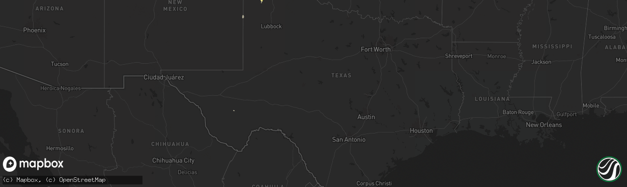
Hail Map in Texas on June 25, 2024
The weather event in Texas on June 25, 2024 includes Wind, Hail, and Tornado maps. 22 states and 2,131 cities were impacted and suffered possible damage. The total estimated number of properties impacted is 268.
Want more than just the map?
Turn this storm into a full workflow.
- Owner + property data so you know who to knock
- OnDemand branded weather history reports to win the "did we even have hail?" argument
- RoofTrace estimate so reps stop guessing numbers at the door
Bought this map? Upgrade within 7 days and we'll credit the $230. (10-15 min setup call)
Wind
Hail
Tornado
268
Estimated number of impacted properties by a 1.00" hail or larger103
Estimated number of impacted properties by a 1.75" hail or larger0
Estimated number of impacted properties by a 2.50" hail or largerStorm reports in Texas
Texas
| Date | Description |
|---|---|
| 06/25/20246:13 PM CDT | Report from mping: quarter |
| 06/25/20246:09 PM CDT | Video received via social media of large healthy tree snapped at base along hwy 70 near chicken creek... North of pampa. Time estimated based on radar. |
| 06/25/20246:09 PM CDT | Corrects previous tstm wnd dmg report from 19 nnw codman. Video received via social media of large healthy tree snapped at base along hwy 70 near chicken creek north of |
| 06/24/20249:11 PM CDT | Report from mping: 1-inch tree limbs broken; shingles blown off. |
| 06/24/20249:07 PM CDT | West texas mesonet. |
| 06/24/20248:03 PM CDT | Picture of large healthy tree branch approximately 1 foot in diameter snapped off tree at ne 14th and n spring st. Report received via social media. Time estimated base |
| 06/24/20247:45 PM CDT | Picture of a large tree knocked over in downtown at 10th and fillmore. Local broadcast media report received via slack. |
| 06/24/20247:42 PM CDT | Mesonet recorded gust of 60 mph at 7:42 pm then subsided. Event was still ongoing at time of report. |
| 06/24/20247:37 PM CDT | Multiple peak wind gusts of 78 mph... With other severe gusts occurring between 7:15 pm and time of report. |
| 06/24/20247:37 PM CDT | Corrects previous tstm wnd gst report from 6 ene amarillo. Multiple peak wind gusts of 78 mph with other severe gusts occurring between 715 pm and time of report. |
| 06/24/20247:36 PM CDT | Public report of semi blown over on westbound i-40 at airport blvd. |
| 06/24/20247:15 PM CDT | Picture of power pole snapped along ne 24th ave in front of the clements unit received via social media. Time estimated based on radar. |
| 06/24/20247:10 PM CDT | Mesonet recorded peak gust of 79mph at 7:10 pm... With other severe gusts occurring from 6:55 to 7:20 pm. |
| 06/24/20247:10 PM CDT | Corrects previous tstm wnd gst report from 9 n amarillo. Mesonet recorded peak gust of 79 mph at 710 pm with other severe gusts occurring from 655 pm to 720 pm. |
All States Impacted by Hail Map on June 25, 2024
Cities Impacted by Hail Map on June 25, 2024
- Whitehall, MI
- Holton, MI
- Muskegon, MI
- Twin Lake, MI
- Montague, MI
- Newaygo, MI
- Fremont, MI
- Grant, MI
- Conklin, MI
- Fenwick, MI
- Rockford, MI
- Fruitport, MI
- Ravenna, MI
- Sparta, MI
- Kent City, MI
- Greenville, MI
- Casnovia, MI
- Sand Lake, MI
- Bailey, MI
- Cedar Springs, MI
- Gowen, MI
- Lowell, MI
- Wayland, MI
- Saugatuck, MI
- Nunica, MI
- Marne, MI
- Hopkins, MI
- Zeeland, MI
- Orleans, MI
- Fennville, MI
- Allendale, MI
- Grandville, MI
- Jenison, MI
- West Olive, MI
- Wyoming, MI
- Caledonia, MI
- Spring Lake, MI
- Dorr, MI
- Byron Center, MI
- Holland, MI
- Allegan, MI
- Belmont, MI
- Grand Rapids, MI
- Comstock Park, MI
- Grand Haven, MI
- Coopersville, MI
- Macatawa, MI
- Belding, MI
- Hudsonville, MI
- Hamilton, MI
- Ada, MI
- Saranac, MI
- Freeport, MI
- Alto, MI
- Ionia, MI
- Lake Odessa, MI
- Middleville, MI
- Portland, MI
- Clarksville, MI
- Hastings, MI
- Shelbyville, MI
- Thomson, IL
- Mount Carroll, IL
- West Branch, IA
- Tipton, IA
- Monroe Center, IL
- Davis Junction, IL
- Kewanee, IL
- Annawan, IL
- Sheffield, IL
- Earlville, IL
- Sterling, IL
- Atalissa, IA
- Chadwick, IL
- Lanark, IL
- Cambridge, IL
- Atkinson, IL
- Geneseo, IL
- Oregon, IL
- Leaf River, IL
- Stillman Valley, IL
- Lindenwood, IL
- Kirkland, IL
- Esmond, IL
- Athens, MI
- Union City, MI
- East Leroy, MI
- Marcellus, MI
- Decatur, MI
- Schoolcraft, MI
- Lawton, MI
- Riverside, IA
- North Aurora, IL
- Aurora, IL
- Watervliet, MI
- Kalona, IA
- Wellman, IA
- Bangor, MI
- Covert, MI
- Milledgeville, IL
- Mchenry, IL
- Polo, IL
- Mount Morris, IL
- Forreston, IL
- Buda, IL
- Kingston, IL
- Chicago, IL
- Lone Tree, IA
- Woodstock, IL
- Galva, IL
- Jackson, MI
- West Liberty, IA
- Grass Lake, MI
- Bennett, IA
- Union, IL
- Marengo, IL
- Huntley, IL
- Wonder Lake, IL
- Dixon, IL
- Neponset, IL
- Sherwood, MI
- Mineral, IL
- Wyanet, IL
- Murray, IA
- Sycamore, IL
- Clare, IL
- Byron, IL
- Plainfield, IL
- Naperville, IL
- Oswego, IL
- Yorkville, IL
- Coloma, MI
- Hartford, MI
- Leland, IL
- Sherrard, IL
- Bishop Hill, IL
- Eau Claire, MI
- Sodus, MI
- Genoa, IL
- Manchester, MI
- Crystal Lake, IL
- Chelsea, MI
- Clarklake, MI
- Brooklyn, MI
- Bradford, IL
- Altona, IL
- Tiskilwa, IL
- Toulon, IL
- Woodhull, IL
- Dowagiac, MI
- Berrien Center, MI
- Franklin Grove, IL
- La Grange, IL
- Amboy, IL
- La Moille, IL
- Sublette, IL
- West Brooklyn, IL
- Morrison, IL
- Cassopolis, MI
- Compton, IL
- Spring Grove, IL
- Iowa City, IA
- Bronson, MI
- Holcomb, IL
- Benton Harbor, MI
- Addison, MI
- Cement City, MI
- Burbank, IL
- Justice, IL
- Willow Springs, IL
- Vandalia, MI
- Rochelle, IL
- Niles, MI
- Berrien Springs, MI
- Island Lake, IL
- Antioch, IL
- Alexis, IL
- Lynn Center, IL
- Newark, IL
- Salem, WI
- Trevor, WI
- Wauconda, IL
- Round Lake, IL
- Cary, IL
- Grayslake, IL
- Barrington, IL
- Ashton, IL
- Thayer, IA
- Steward, IL
- Bolingbrook, IL
- Twin Lakes, WI
- Richmond, IL
- Orland, IN
- Howe, IN
- Jones, MI
- White Pigeon, MI
- Oneida, IL
- New Boston, IL
- Joy, IL
- Seaton, IL
- Edwardsburg, MI
- Evergreen Park, IL
- Keota, IA
- Aledo, IL
- Little York, IL
- Shorewood, IL
- Minooka, IL
- Union, MI
- Lagrange, IN
- La Fayette, IL
- Mendota, IL
- Bristol, IN
- Joliet, IL
- Galesburg, IL
- Rio, IL
- Lake Villa, IL
- West Chester, IA
- Washington, IA
- Angola, IN
- Buchanan, MI
- Henderson, IL
- Wataga, IL
- Orion, IL
- Walkerton, IN
- Gerlaw, IL
- Ottawa, IL
- Wolcottville, IN
- La Salle, IL
- Peru, IL
- Utica, IL
- Serena, IL
- Hudson, IN
- South Bend, IN
- North Liberty, IN
- Wauseon, OH
- Delta, OH
- Wyoming, IL
- Elkhart, IN
- Osceola, IN
- Granger, IN
- Mishawaka, IN
- Victoria, IL
- Goshen, IN
- Seneca, IL
- Wedron, IL
- Wakarusa, IN
- Marseilles, IL
- Speer, IL
- Middlebury, IN
- Alpha, IL
- Pleasant Lake, IN
- Lakeville, IN
- Bremen, IN
- Ligonier, IN
- Hamlet, IN
- Union Mills, IN
- Westville, IN
- Kingsford Heights, IN
- La Porte, IN
- Davis City, IA
- Williamsfield, IL
- Monmouth, IL
- North Henderson, IL
- Nappanee, IN
- New Paris, IN
- Leon, IA
- Lineville, IA
- Princeville, IL
- Oquawka, IL
- Knoxville, IL
- Syracuse, IN
- Millersburg, IN
- Grovertown, IN
- Plymouth, IN
- Laura, IL
- Leesburg, IN
- Milford, IN
- Cromwell, IN
- Etna Green, IN
- Warsaw, IN
- Dahinda, IL
- East Galesburg, IL
- Brimfield, IL
- Rochester, IN
- Culver, IN
- Pierceton, IN
- Winona Lake, IN
- Larwill, IN
- Columbia City, IN
- North Webster, IN
- Elmwood, IL
- Cainsville, MO
- El Paso, IL
- Roanoke, IL
- Benson, IL
- Mercer, MO
- Gilson, IL
- La Fontaine, IN
- Wabash, IN
- Pekin, IL
- Keosauqua, IA
- Deer Creek, IL
- Eureka, IL
- Washington, IL
- Morton, IL
- Walton, IN
- Galveston, IN
- Logansport, IN
- East Peoria, IL
- Metamora, IL
- South Pekin, IL
- Tremont, IL
- Green Valley, IL
- Peoria, IL
- Groveland, IL
- Creve Coeur, IL
- Peoria Heights, IL
- Wapakoneta, OH
- Bonaparte, IA
- Fairview, IL
- Canton, IL
- Ellisville, IL
- Smithfield, IL
- Anna, OH
- Jackson Center, OH
- Maplewood, OH
- Sidney, OH
- Camden, IN
- Delavan, IL
- Port Jefferson, OH
- Botkins, OH
- Quincy, OH
- De Graff, OH
- Topeka, IL
- Havana, IL
- Stanford, IL
- Minier, IL
- Cuba, IL
- Armington, IL
- Milton, IA
- Douds, IA
- Manito, IL
- Forest City, IL
- Bellefontaine, OH
- Lewistown, OH
- Huntsville, OH
- Table Grove, IL
- Adair, IL
- Summitville, IN
- Alexandria, IN
- Kahoka, MO
- Farmington, IA
- Mount Sterling, IA
- West Liberty, OH
- Hopedale, IL
- Lewistown, IL
- Vermont, IL
- Ipava, IL
- McLean, IL
- Easton, IL
- Mason City, IL
- Zanesfield, OH
- Urbana, OH
- San Jose, IL
- New Holland, IL
- Bryant, IL
- Pendleton, IN
- Emden, IL
- Atlanta, IL
- Rushville, IL
- Industry, IL
- Liverpool, IL
- Fortville, IN
- Greenfield, IN
- Macomb, IL
- Hartsburg, IL
- Plymouth, IL
- Littleton, IL
- Augusta, IL
- Kenney, IL
- Lincoln, IL
- Waterloo, IN
- Ashley, IN
- London, OH
- Maroa, IL
- Chestnut, IL
- Charlottesville, IN
- Camden, IL
- Huntsville, IL
- Mount Pulaski, IL
- Carthage, IN
- Morristown, IN
- Arlington, IN
- Downing, MO
- Argenta, IL
- Latham, IL
- Arcola, IL
- Cerro Gordo, IL
- Milmine, IL
- La Prairie, IL
- Arthur, IL
- Tuscola, IL
- Petersburg, IL
- Greenview, IL
- Golden, IL
- Humboldt, IL
- Shelbyville, IN
- Waldron, IN
- Manilla, IN
- Athens, IL
- Clinton, IL
- Charleston, IL
- Brocton, IL
- Sullivan, IL
- Hindsboro, IL
- Mattoon, IL
- Oakland, IL
- Oreana, IL
- Monticello, IL
- Bement, IL
- Cisco, IL
- Timewell, IL
- Tallula, IL
- Beason, IL
- Oakford, IL
- Newman, IL
- Glasford, IL
- Astoria, IL
- Browning, IL
- Mount Sterling, IL
- Saint David, IL
- Kansas, IL
- Paris, IL
- Chillicothe, OH
- Frederick, IL
- Ashmore, IL
- Redmon, IL
- Ashland, IL
- Martinsville, IL
- Dennison, IL
- West Terre Haute, IN
- Quincy, IL
- Marshall, IL
- Meredosia, IL
- Jacksonville, IL
- Maywood, MO
- Durham, MO
- Cantrall, IL
- Springfield, IL
- Chapin, IL
- La Grange, MO
- Ewing, MO
- Mendon, IL
- Terre Haute, IN
- Winchester, IL
- Bluffs, IL
- Clayton, IL
- Camp Point, IL
- Fowler, IL
- Greenup, IL
- Sherman, IL
- Concord, IL
- Arenzville, IL
- Brazil, IN
- Riley, IN
- Taylor, MO
- Staunton, IN
- Farmersburg, IN
- Cory, IN
- Pleasant Plains, IL
- Cordesville, SC
- Annapolis, IL
- Willow Hill, IL
- Oblong, IL
- Buffalo, IL
- Paloma, IL
- Coatsburg, IL
- Centerpoint, IN
- Clay City, IN
- Bowling Green, IN
- Coal City, IN
- West Liberty, IL
- North Vernon, IN
- Dundas, IL
- Seymour, IN
- Versailles, IL
- Stoy, IL
- Robinson, IL
- Sullivan, IN
- Liberty, IL
- Alexander, IL
- New Berlin, IL
- Shelburn, IN
- Freedom, IN
- Sumner, IL
- Patricksburg, IN
- Spencer, IN
- Poland, IN
- Carlisle, IN
- Merom, IN
- Claremont, IL
- Flat Rock, IL
- Olney, IL
- Xenia, IL
- Dugger, IN
- Linton, IN
- Noble, IL
- Dawson, IL
- Riverton, IL
- Commiskey, IN
- Barry, IL
- Pittsfield, IL
- Brownstown, IN
- Crothersville, IN
- Bloomington, IN
- Kinderhook, IL
- Oaktown, IN
- Lawrenceville, IL
- Palestine, IL
- New Canton, IL
- Flora, IL
- Rinard, IL
- Hull, IL
- Rochester, IL
- Bridgeport, IL
- Baylis, IL
- New London, MO
- Bowman, SC
- Plainville, IL
- Clay City, IL
- Cisne, IL
- Green Cove Springs, FL
- West Union, IL
- Mount Erie, IL
- New Salem, IL
- Griggsville, IL
- Chambersburg, IL
- Calhoun, IL
- Elnora, IN
- West Salem, IL
- Washington, IN
- Ellettsville, IN
- Solsberry, IN
- Montgomery, IN
- Plainville, IN
- Seligman, AZ
- Parkersburg, IL
- Vincennes, IN
- Monroe City, IN
- Wheatland, IN
- Nashville, IN
- Saint Francisville, IL
- Murrayville, IL
- Mount Carmel, IL
- Rockport, IL
- Bicknell, IN
- Edwardsport, IN
- Vermilion, IL
- Gosport, IN
- Norman, IN
- Heltonville, IN
- Medora, IN
- Freetown, IN
- Vallonia, IN
- Pleasant Hill, IL
- Columbus, IN
- Ava, MO
- Squires, MO
- Geff, IL
- O'Brien, FL
- Sims, IL
- Summerton, SC
- Hazleton, IN
- Decker, IN
- Zolfo Springs, FL
- Vale, SD
- Newell, SD
- Waverly, IL
- Young, AZ
- Campbellsburg, IN
- Franklin, IL
- Golden Gate, IL
- Fairfield, IL
- Nisland, SD
- Francisco, IN
- Patoka, IN
- Payson, AZ
- Loami, IL
- Sturgis, SD
- Chatham, IL
- Hackberry, AZ
- Princeton, IN
- Jasper, IN
- Velpen, IN
- Huntingburg, IN
- Johnsonville, IL
- Albion, IL
- Palmyra, IL
- Paris Crossing, IN
- Austin, IN
- Bluford, IL
- New Carlisle, IN
- Galien, MI
- Enning, SD
- Union Center, SD
- Miles, IA
- Sabula, IA
- Louisiana, MO
- Ellery, IL
- Newton, IA
- McAlpin, FL
- Lexington, IN
- Scottsburg, IN
- Deputy, IN
- Stoutsville, MO
- Live Oak, FL
- Center, MO
- New Underwood, SD
- Vandalia, MO
- Frankford, MO
- Show Low, AZ
- Slater, MO
- Armstrong, MO
- Glasgow, MO
- Salisbury, MO
- Howes, SD
- Tallahassee, FL
- White Owl, SD
- Preston, IA
- Curryville, MO
- Perry, MO
- Fayette, MO
- Wasta, SD
- Santa Fe, MO
- Ridgeville, SC
- Gilliam, MO
- Walterboro, SC
- Amite, LA
- Greensburg, LA
- Higbee, MO
- Omaha, NE
- Council Bluffs, IA
- Shannon, IL
- Grinnell, IA
- Wall, SD
- Colfax, IA
- Summerville, SC
- Madison, MO
- Kellogg, IA
- Clinton, IA
- Fulton, IL
- Louisville, KY
- Sedona, AZ
- Saint Louis, MO
- Owanka, SD
- Box Elder, SD
- Bellevue, NE
- Garden Prairie, IL
- Harvard, IL
- Holliday, MO
- Paris, MO
- Monroe, IA
- Runnells, IA
- Mitchellville, IA
- Prairie City, IA
- Rocheport, MO
- Malcom, IA
- Marland, OK
- Gregory, SD
- Mexico, MO
- Harrisburg, MO
- Clark, MO
- Sturgeon, MO
- Ponca City, OK
- Coulterville, IL
- Mechanicsville, IA
- Winfield, KS
- Centralia, MO
- Laddonia, MO
- Thompson, MO
- Quinn, SD
- Philip, SD
- Ely, IA
- Bassett, NE
- Arkansas City, KS
- New Franklin, MO
- Kaw City, OK
- Belle, MO
- Offutt Afb, NE
- Fernley, NV
- Silver Springs, NV
- Farber, MO
- Plainview, NE
- Neligh, NE
- Lisbon, IA
- Boonville, MO
- Meadow Grove, NE
- Brooklyn, IA
- Pierce, NE
- Ewing, NE
- Inman, NE
- Stuart, NE
- Atkinson, NE
- Amelia, NE
- La Vista, NE
- Papillion, NE
- Pacific Junction, IA
- Franklin, MO
- Potosi, MO
- Belvidere, IL
- Wellington, KS
- Bryant, IA
- Glenwood, IA
- Rapid City, SD
- Tilden, NE
- Battle Creek, NE
- Delmar, IA
- Maquoketa, IA
- Newkirk, OK
- Burwell, NE
- Belle Plaine, KS
- Rimrock, AZ
- Auxvasse, MO
- Imperial, MO
- Barnhart, MO
- Mulvane, KS
- Udall, KS
- Hermosa, SD
- Caputa, SD
- Clearwater, NE
- Hartford, IA
- Swan, IA
- Carlisle, IA
- Pleasantville, IA
- Ackworth, IA
- Miami, TX
- Clarence, IA
- Charlotte, IA
- Hillsboro, MO
- Mount Vernon, IL
- Ralston, OK
- Shidler, OK
- Burbank, OK
- New Haven, MO
- Stockport, IA
- Hampshire, IL
- Warrenton, MO
- Goose Lake, IA
- Scenic, SD
- Kyle, SD
- Columbia, IL
- Kingdom City, MO
- Fulton, MO
- Palmyra, MO
- Valentine, NE
- Crescent, IA
- Seneca, NE
- Kadoka, SD
- Interior, SD
- Wanblee, SD
- Lewistown, MO
- Mullen, NE
- Pleasant Hill, IA
- Des Moines, IA
- Corydon, KY
- Henderson, KY
- Plattsmouth, NE
- Panhandle, TX
- Amarillo, TX
- Portales, NM
- Carter Lake, IA
- Norfolk, NE
- Norwalk, IA
- Altoona, IA
- Red Rock, OK
- Pawnee, OK
- Berger, MO
- Hermann, MO
- Cumming, IA
- Mclean, NE
- Osmond, NE
- De Soto, MO
- Orange City, FL
- Stanwood, IA
- Indianola, IA
- Oxford, KS
- Leslie, MO
- Blackwell, MO
- Fletcher, MO
- Solon, IA
- Allen, SD
- Mount Vernon, IA
- Danville, IA
- Prole, IA
- Madison, NE
- North Liberty, IA
- Festus, MO
- Owensville, MO
- Marathon, TX
- Randolph, NE
- Coleridge, NE
- La Belle, MO
- Knox City, MO
- Honey Creek, IA
- Underwood, IA
- Coralville, IA
- Debary, FL
- Neola, IA
- Martin, SD
- Magnet, NE
- Hartington, NE
- New London, IA
- Chariton, IA
- Lacona, IA
- Knoxville, IA
- De Witt, IA
- Williamstown, MO
- Monticello, MO
- Perry, OK
- Pawhuska, OK
- Russell, IA
- New Windsor, IL
- Tiffin, IA
- Lucas, IA
- Oxford, IA
- Pevely, MO
- Hills, IA
- Van Meter, IA
- Belle Rive, IL
- Viola, IL
- Bloomfield, NE
- Billings, OK
- Minden, IA
- Persia, IA
- Shelby, IA
- Avoca, IA
- Melcher Dallas, IA
- Columbia, IA
- Wyaconda, MO
- Morrison, OK
- Canton, MO
- Springfield, NE
- Owensboro, KY
- West Burlington, IA
- Yarmouth, IA
- Burlington, IA
- Sperry, IA
- Johnstown, NE
- Nichols, IA
- Sebree, KY
- Robards, KY
- Luray, MO
- Genoa City, WI
- San Manuel, AZ
- French Village, MO
- Tuthill, SD
- Merriman, NE
- Cody, NE
- Claude, TX
- Canyon, TX
- Stanton, NE
- Clarkson, NE
- Creston, NE
- Leigh, NE
- Long Valley, SD
- Causey, NM
- Calhoun, KY
- Saint Patrick, MO
- Blackwell, OK
- Slaughters, KY
- Dixon, KY
- Sparland, IL
- Farmington, MO
- Sainte Genevieve, MO
- South Amana, IA
- Homestead, IA
- Marengo, IA
- Sparks, NV
- Mineral Point, MO
- Putnam, IL
- Henry, IL
- Madisonville, KY
- Nebo, KY
- Van Buren, MO
- Ellington, MO
- Irondale, MO
- Lindsay, NE
- Saint Edward, NE
- Humphrey, NE
- Monroe, NE
- Wausa, NE
- Creighton, NE
- Norris, SD
- Page, NE
- Orchard, NE
- Orlando, OK
- Stillwater, OK
- Laurel, NE
- Newcastle, NE
- Ponca, NE
- Muscatine, IA
- Wilton, IA
- Durant, IA
- Moscow, IA
- Illinois City, IL
- Stockton, IA
- Walcott, IA
- Davenport, IA
- Blue Grass, IA
- Reynolds, IL
- Andalusia, IL
- Buffalo, IA
- Montpelier, IA
- Taylor Ridge, IL
- Milan, IL
- Rock Island, IL
- Missouri Valley, IA
- Bettendorf, IA
- Logan, IA
- Janesville, WI
- Brodhead, WI
- Sedan, KS
- Bonne Terre, MO
- Park Hills, MO
- Winner, SD
- Corydon, IA
- Manitou, KY
- Pampa, TX
- Vienna, MO
- Cedar Vale, KS
- Tonkawa, OK
- Keithsburg, IL
- Derby, IA
- Melrose, IA
- Bloomsdale, MO
- Harlan, IA
- Schuyler, NE
- Evansville, WI
- Crofton, NE
- Whitman, NE
- Milton, WI
- Avalon, WI
- Whitewater, WI
- Darien, WI
- Winnetoon, NE
- Platte Center, NE
- Winfield, IA
- Olds, IA
- Crawfordsville, IA
- Mount Pleasant, IA
- Osco, IL
- Wood, SD
- Ladora, IA
- Lovington, NM
- Parmelee, SD
- White River, SD
- Adel, IA
- Earlham, IA
- Winterset, IA
- Montezuma, IA
- West Des Moines, IA
- Saint Charles, IA
- Bevington, IA
- Truro, IA
- Williamsburg, IA
- Rogers, NM
- Cadet, MO
- New Virginia, IA
- Kirkwood, IL
- Hanson, KY
- Edelstein, IL
- Chillicothe, IL
- Coal Valley, IL
- Footville, WI
- Cantril, IA
- Nashville, IL
- Patterson, IA
- Woodbine, IA
- Portsmouth, IA
- Kirkman, IA
- Irwin, IA
- Grand River, IA
- Van Wert, IA
- Mulhall, OK
- Perkins, OK
- Coyle, OK
- Elk City, KS
- Modale, IA
- Saint Francis, SD
- Orfordville, WI
- Lowpoint, IL
- Peru, IA
- Lorimor, IA
- Fort Calhoun, NE
- Blair, NE
- Galena, IL
- Scales Mound, IL
- Elizabeth, IL
- Panama, IA
- Ophiem, IL
- Ashley, IL
- Du Bois, IL
- Yates City, IL
- Vichy, MO
- Menlo, IA
- Greenfield, IA
- Kimballton, IA
- Audubon, IA
- Manning, IA
- Fordyce, NE
- Hoskins, NE
- Verdigre, NE
- Havana, KS
- Independence, KS
- Covington, OK
- Cameron, IL
- Magnolia, IA
- Farmington, IL
- Hancock, IA
- Washburn, IL
- Maquon, IL
- Royal, NE
- Richwoods, MO
- Swisher, IA
- Mediapolis, IA
- Piedmont, MO
- Mill Spring, MO
- Middletown, IA
- Patterson, MO
- Garber, OK
- Mission, SD
- Mount Union, IA
- Tryon, OK
- Meridian, OK
- Wellston, OK
- Guthrie, OK
- Happy, TX
- Tulia, TX
- Pond Creek, OK
- Arbela, MO
- Fleming Island, FL
- Jacksonville, FL
- Westphalia, IA
- Earling, IA
- Sharon, OK
- Kilgore, NE
- McClelland, IA
- De Soto, IA
- Marshall, OK
- Douglas, OK
- Lucien, OK
- Saint Mary, MO
- Stuart, IA
- Guthrie Center, IA
- Panora, IA
- Winside, NE
- Wynot, NE
- Saint Helena, NE
- Luther, OK
- Carney, OK
- Dunlap, IA
- Hunter, OK
- Gordon, NE
- London Mills, IL
- Conesville, IA
- Longton, KS
- Hennessey, OK
- Denison, IA
- Ainsworth, IA
- Columbus Junction, IA
- Bourbon, MO
- Mapleton, IL
- Hanna City, IL
- Hamlin, IA
- Coon Rapids, IA
- Adair, IA
- Bison, OK
- Crescent, OK
- Kingfisher, OK
- Cashion, OK
- Tryon, NE
- Little Sioux, IA
- Onawa, IA
- Pisgah, IA
- Soldier, IA
- Moorhead, IA
- Cottageville, SC
- Salem, IA
- Manilla, IA
- Afton, IA
- Wayne, NE
- Pilger, NE
- Pinckneyville, IL
- Dixon, NE
- Letts, IA
- Osceola, IA
- Mondamin, IA
- Tekamah, NE
- Bennington, NE
- Dow City, IA
- Ute, IA
- Rogers, NE
- Dodge, NE
- Howells, NE
- Valley, NE
- Elkhorn, NE
- Waterloo, NE
- Linden, IA
- Redfield, IA
- Moulton, IA
- Coatsville, MO
- Bloomfield, IA
- Dexter, IA
- Ellston, IA
- Nash, OK
- West Point, IA
- Wooldridge, MO
- Jamestown, MO
- Cherryvale, KS
- Columbia, MO
- Arlington, NE
- Kennard, NE
- Arnett, OK
- Cedar Bluffs, NE
- Morse Bluff, NE
- North Bend, NE
- Lancaster, MO
- Charter Oak, IA
- Piedmont, OK
- Edmond, OK
- Arcadia, OK
- Oakland, IA
- Treynor, IA
- Macedonia, IA
- Silver City, IA
- Carson, IA
- Sutherland, NE
- Vail, IA
- Westside, IA
- Casey, IA
- Enid, OK
- Niobrara, NE
- Shannon City, IA
- Thedford, NE
- Creston, IA
- Wapello, IA
- Fontanelle, IA
- Queen City, MO
- Kiron, IA
- Deloit, IA
- Diagonal, IA
- Kilbourne, IL
- Weldon, IA
- Decatur, IA
- Gerald, MO
- Lenox, IA
- Dimmitt, TX
- Springfield, SD
- Newport, NE
- Orient, IA
- Hereford, TX
- Minburn, IA
- Dallas Center, IA
- Waukee, IA
- Oklahoma City, OK
- Bethany, OK
- Yukon, OK
- Choctaw, OK
- Jones, OK
- Spencer, OK
- Albion, NE
- Newman Grove, NE
- Emerson, IA
- Red Oak, IA
- Griswold, IA
- Elliott, IA
- Henderson, IA
- Lewis, IA
- Cumberland, IA
- Atlantic, IA
- Villisca, IA
- Grant, IA
- New Bloomfield, MO
- Prescott, IA
- Macksburg, IA
- Elgin, NE
- Nazareth, TX
- Corning, IA
- Donnellson, IA
- Bisbee, AZ
- Hillsboro, IA
- Martensdale, IA
- Washington, NE
- Hartsburg, MO
- Purdum, NE
- Williamson, IA
- Milo, IA
- Montgomery City, MO
- Williamsburg, MO
- Norman, OK
- Columbus, NE
- Center, NE
- Mount Ayr, IA
- Kellerton, IA
- Murphysboro, IL
- Ava, IL
- Ellsinore, MO
- Morning Sun, IA
- Tingley, IA
- Newark, MO
- Genoa, NE
- Carbon, IA
- Massena, IA
- Nodaway, IA
- Bridgewater, IA
- Urbandale, IA
- Clive, IA
- Grimes, IA
- Harrah, OK
- Mcloud, OK
- Newalla, OK
- Hart, TX
- Clearfield, IA
- Jefferson City, MO
- Lamoni, IA
- Alexandria, MO
- Ames, NE
- Ashland, MO
- Fredericktown, MO
- Fremont, NE
- Gravity, IA
- Yutan, NE
- Colon, NE
- Bethel, MO
- Benton, IA
- Blockton, IA
- Des Arc, MO
- Annapolis, MO
- New Market, IA
- Bedford, IA
- Sharpsburg, IA
- Boys Town, NE
- Shawnee, OK
- Tecumseh, OK
- Noble, OK
- Wanette, OK
- Macomb, OK
- Lexington, OK
- Clarinda, IA
- Avon, SD
- Millerton, IA
- Shambaugh, IA
- Lovilia, IA
- Plano, IA
- Promise City, IA
- Marquand, MO
- Schleswig, IA
- Evansville, IN
- Nebraska City, NE
- Oneill, NE
- Chambers, NE
- Talmage, NE
- Nickerson, NE
- Cedar Rapids, NE
- Redding, IA
- Brock, NE
- Herman, NE
- Sheridan, MO
- Hopkins, MO
- Salem, KY
- Marion, KY
- Julian, NE
- Peru, NE
- Humeston, IA
- Fullerton, NE
- Hagarville, AR
- Lamar, AR
- Hershey, NE
- Hatfield, MO
- Patton, MO
- Garden Grove, IA
- Perryville, MO
- Belgrade, NE
- Malvern, IA
- Cape Girardeau, MO
- Chaffee, MO
- Ord, NE
- Elyria, NE
- Silver Creek, NE
- Osceola, NE
- Clarks, NE
- Wolbach, NE
- Auburn, NE
- Brownville, NE
- Stanberry, MO
- Primrose, NE
- Shelbina, MO
- Grant City, MO
- Fairfax, MO
- Rock Port, MO
- Denver, MO
- Worth, MO
- Pickering, MO
- Parnell, MO
- Maryville, MO
- Ravenwood, MO
- Barnard, MO
- Gentry, MO
- Conception Junction, MO
- Skidmore, MO
- Graham, MO
- Bolckow, MO
- Conception, MO
- Clyde, MO
- Guilford, MO
- Martinsville, MO
- Darlington, MO
- Rea, MO
- New Hampton, MO
- McFall, MO
- Rosendale, MO
- Albany, MO
- Bethany, MO
- King City, MO
- Eagleville, MO
- Ridgeway, MO
- Blythedale, MO
- Princeton, MO
- Savannah, MO
- Union Star, MO
- Dunbar, NE
- Milan, MO
- Pollock, MO
- Kremlin, OK
- Green City, MO
- Lorton, NE
- Randolph, IA
- Unionville, MO
- Farragut, IA
- Glenwood, MO
- Payson, IL
- Nemaha, NE
- Kirksville, MO
- Brashear, MO
- Amity, MO
- Maysville, MO
- Central City, NE
- Essex, IA
- Shenandoah, IA
- Greenville, MO
- Imogene, IA
- Avoca, NE
- Riverton, IA
- Sidney, IA
- Wadesville, IN
- Craig, MO
- Oakdale, NE
- Falls City, NE
- Shubert, NE
- Verdon, NE
- Stella, NE
- Stromsburg, NE
- Polk, NE
- Hordville, NE
- Ashland, NE
- Petersburg, NE
- Otoe, NE
- Saint Paul, NE
- Palmer, NE
- Archer, NE
- Chapman, NE
- Boelus, NE
- Saint Libory, NE
- Dannebrog, NE
- Cairo, NE
- Rockville, NE
- Marquette, NE
- Wood River, NE
- Gibbon, NE
- Grand Island, NE
- Shelton, NE
- Ravenna, NE
- Phillips, NE
- Alda, NE
- Kenesaw, NE
- Juniata, NE
- Aurora, NE
- Hastings, NE
- Doniphan, NE
- Trumbull, NE
- Giltner, NE
- Maitland, MO
- Oregon, MO
- White Cloud, KS
- Forest City, MO
- Mound City, MO
- Rulo, NE
- Coffey, MO
- Gilman City, MO
- Humphreys, MO
- Jamesport, MO
- Galt, MO
- Pattonsburg, MO
- Spickard, MO
- Jameson, MO
- Trenton, MO
- Harris, MO
- Laredo, MO
- Altamont, MO
- Helena, MO
- Gallatin, MO
- Browning, MO
- Easton, MO
- Clarksdale, MO
- Weatherby, MO
- Cameron, MO
- Saint Joseph, MO
- Winston, MO
- Osborn, MO
- Stewartsville, MO
- Cosby, MO
- Ewing, IL
- Macedonia, IL
- Breckenridge, MO
- Hamilton, MO
- Chula, MO
- Chillicothe, MO
- Lock Springs, MO
- Kidder, MO
- Wheeling, MO
- Garland, NE
- Malcolm, NE
- Pleasant Dale, NE
- Benedict, NE
- Grandin, MO
- Greenwood, NE
- Neodesha, KS
- Valles Mines, MO
- Syracuse, NE
- Palmyra, NE
- Unadilla, NE
- Taylor, NE
- Lincoln, NE
- Saronville, NE
- Bradshaw, NE
- Clay Center, NE
- Hampton, NE
- Sutton, NE
- Harvard, NE
- York, NE
- Inland, NE
- Henderson, NE
- Louisville, NE
- Almo, KY
- Benton, KY
- Hardin, KY
- Dexter, KY
- South Bend, NE
- Murray, NE
- Nehawka, NE
- Memphis, MO
- Gretna, NE
- Naylor, MO
- Success, AR
- Vergennes, IL
- Templeton, IA
- Saint Paul, IA
- Liberty, KS
- Waverly, NE
- Moline, IL
- Amazonia, MO
- Seward, NE
- Milford, NE
- Cordova, NE
- Beaver Crossing, NE
- Exeter, NE
- McCool Junction, NE
- Waco, NE
- Utica, NE
- Friend, NE
- Fairmont, NE
- Dorchester, NE
- Grafton, NE
- Geneva, NE
- Tobias, NE
- Milligan, NE
- Ohiowa, NE
- Linneus, MO
- Meadville, MO
- Mooresville, MO
- Utica, MO
- Plattsburg, MO
- Braymer, MO
- Dawn, MO
- Turney, MO
- Cowgill, MO
- Lawson, MO
- Ludlow, MO
- Kingston, MO
- Polo, MO
- Lathrop, MO
- Wagner, SD
- Whitewater, MO
- Marble Hill, MO
- Burfordville, MO
- Highland, KS
- Troy, KS
- Palmersville, TN
- Fulton, KY
- Sedalia, KY
- Dukedom, TN
- De Soto, IL
- Brunswick, NE
- Vermillion, SD
- Murray, KY
- Green Castle, MO
- Wathena, KS
- Sedgewickville, MO
- Cedar Creek, NE
- Sterling, NE
- Cook, NE
- Robinson, KS
- Doniphan, MO
- Superior, NE
- Daykin, NE
- Byron, NE
- Deshler, NE
- Jackson, MO
- Lost Nation, IA
- Oak Ridge, MO
- Glenallen, MO
- Millersville, MO
- Alexandria, NE
- Chamois, MO
- Rayville, MO
- Hardin, MO
- Carrollton, MO
- Tina, MO
- Bogard, MO
- Norborne, MO
- Richmond, MO
- Hale, MO
- Bosworth, MO
- Odell, NE
- Crete, NE
- Clatonia, NE
- Cortland, NE
- Beatrice, NE
- Swanton, NE
- Virginia, NE
- Filley, NE
- Blue Springs, NE
- Wymore, NE
- Wilber, NE
- Hallam, NE
- De Witt, NE
- Plymouth, NE
- Pickrell, NE
- Western, NE
- Steele City, NE
- Diller, NE
- Jansen, NE
- Fairbury, NE
- Bremen, KS
- Hollenberg, KS
- Barnes, KS
- Hanover, KS
- Marysville, KS
- Greenleaf, KS
- Washington, KS
- Endicott, NE
- Hubbell, NE
- Gilead, NE
- Reynolds, NE
- Hebron, NE
- Narka, KS
- Scandia, KS
- Republic, KS
- Munden, KS
- Norway, KS
- Courtland, KS
- Belleville, KS
- Strang, NE
- Ethel, MO
- Elmer, MO
- Buchanan, TN
- New Concord, KY
- Maynard, AR
- Poplar Bluff, MO
- Williamsville, MO
- Denton, KS
- Mendon, MO
- Tecumseh, NE
- Chester, NE
- Warm Springs, AR
- Atchison, KS
- Jamestown, KS
- Pocahontas, AR
- Mahaska, KS
- Tamms, IL
- Ullin, IL
- Dongola, IL
- Keytesville, MO
- Anna, IL
- Higginsville, MO
- Malta Bend, MO
- Alma, MO
- Marshall, MO
- Dover, MO
- De Witt, MO
- Corder, MO
- Lexington, MO
- Waverly, MO
- Blackburn, MO
- Miami, MO
- Morrowville, KS
- Lewiston, NE
- Home, KS
- Beattie, KS
- Oketo, KS
- Barneston, NE
- Summerfield, KS
- Burchard, NE
- Pawnee City, NE
- Liberty, NE
- Axtell, KS
- Cuba, KS
- Haddam, KS
- Agenda, KS
- Morganville, KS
- Aurora, KS
- Linn, KS
- Blue Rapids, KS
- Concordia, KS
- Clyde, KS
- Clifton, KS
- Frankfort, KS
- Waterville, KS
- Palmer, KS
- Rockwood, IL
- Lodi, MO
- Clubb, MO
- Silva, MO
- Imboden, AR
- S Coffeyville, OK
- Arcadia, MO
- Baileyville, KS
- Erie, KS
- Chanute, KS
- Humboldt, KS
- Neosho Falls, KS
- Colony, KS
- Neelyville, MO
- Dover, TN
- Bevier, MO
- Beech Grove, AR
- Lenapah, OK
- Du Quoin, IL
- Elkville, IL
- Yorktown, IA
- Callao, MO
- Macon, MO
- Peach Orchard, AR
- Delaplaine, AR
- Onaga, KS
- Leonardville, KS
- Olsburg, KS
- Havensville, KS
- Westmoreland, KS
- Clay Center, KS
- Centralia, KS
- Vermillion, KS
- Randolph, KS
- Green, KS
- Corning, KS
- Miltonvale, KS
- Triplett, MO
- Huntsville, MO
- Dalton, MO
- Moberly, MO
- Clifton Hill, MO
- Brunswick, MO
- Nelson, MO
- Henrietta, MO
- Blackwater, MO
- Camden, MO
- Mayview, MO
- Concordia, MO
- Sweet Springs, MO
- Napoleon, MO
- Sibley, MO
- Oak Grove, MO
- Odessa, MO
- Orrick, MO
- Arrow Rock, MO
- Wellington, MO
- Bates City, MO
- Lone Jack, MO
- Houstonia, MO
- La Monte, MO
- Kingsville, MO
- Holden, MO
- Centerview, MO
- Knob Noster, MO
- Warrensburg, MO
- Pilot Grove, MO
- Hughesville, MO
- Sedalia, MO
- Sabetha, KS
- Wetmore, KS
- Seneca, KS
- Goff, KS
- Hooper, NE
- Du Bois, NE
- Mead, NE
- Coffeyville, KS
- Bern, KS
- New Boston, MO
- Biggers, AR
- Wann, OK
- Clearmont, MO
- Braddyville, IA
- Riley, KS
- Manhattan, KS
- Saint George, KS
- Wamego, KS
- Wakefield, KS
- Holton, KS
- Saint Marys, KS
- Soldier, KS
- Circleville, KS
- Belvue, KS
- Delia, KS
- Emmett, KS
- Iola, KS
- Rothville, MO
- Steelville, MO
- Cypress, IL
- Grand Chain, IL
- Vienna, IL
- Belknap, IL
- Karnak, IL
- Ironton, MO
- Whiting, KS
- Netawaka, KS
- Powhattan, KS
- Mayetta, KS
- Denison, KS
- Silver Lake, KS
- Topeka, KS
- Rossville, KS
- Maple Hill, KS
- Alma, KS
- Hoyt, KS
- Paxico, KS
- McFarland, KS
- Milford, KS
- Longford, KS
- Ogden, KS
- Eskridge, KS
- Harveyville, KS
- Auburn, KS
- Carbondale, KS
- Osawatomie, KS
- Wakarusa, KS
- Rantoul, KS
- Berryton, KS
- Ottawa, KS
- Overbrook, KS
- Pomona, KS
- Burlingame, KS
- Peru, KS
- Niotaze, KS
- Golconda, IL
- Independence, MO
- Buckner, MO
- Scranton, KS
- Quenemo, KS
- Vassar, KS
- Lyndon, KS
- Osage City, KS
- Tecumseh, KS
- Lawrence, KS
- Wellsville, KS
- Baldwin City, KS
- Reading, KS
- Allen, KS
- Jonesboro, AR
- Hampton, KY
- Smithland, KY
- Grain Valley, MO
- Galesburg, KS
- Richmond, KS
- Princeton, KS
- Halsey, NE
- Hanover, IN
- Blue Springs, MO
- La Plata, MO
- Novinger, MO
- Minneapolis, KS
- Solomon, KS
- Bennington, KS
- Kirksey, KY
- Piqua, KS
- Oxly, MO
- Claremore, OK
- Stilwell, KS
- Spalding, NE
- Clinton, MO
- Copan, OK
- Harrisburg, AR
- Weiner, AR
- Bay, AR
- Chelsea, OK
- Arnold, NE
- Winigan, MO
- Mayfield, KY
- Weeping Water, NE
- Garnett, KS
- Parsons, KS
- Centerville, KS
- Corning, AR
- Cole Camp, MO
- Mora, MO
- Chilhowee, MO
- Kincaid, KS
- Lane, KS
- Fillmore, MO
- Caney, KS
- Tyro, KS
- New Cambria, MO
- Winslow, IN
- Stover, MO
- Ansley, NE
- Mason City, NE
- Zalma, MO
- Lowndes, MO
- Wappapello, MO
- Lebo, KS
- Melvern, KS
- Waverly, KS
- Greeley, KS
- Williamsburg, KS
- Westphalia, KS
- Welda, KS
- Paola, KS
- Parker, KS
- Blue Mound, KS
- Burlington, KS
- Le Roy, KS
- Laclede, MO
- Brookfield, MO
- Gipsy, MO
- Atlanta, MO
- State University, AR
- Paragould, AR
- Dennis, KS
- Mound Valley, KS
- Warsaw, MO
- Uniontown, KS
- Bronson, KS
- Stark, KS
- Delaware, OK
- Barnsdall, OK
- Bartlesville, OK
- Humboldt, TN
- Elfrida, AZ
- Ochelata, OK
- Walnut, KS
- Elwood, KS
- Humansville, MO
- Collins, MO
- Pollard, AR
- Pittsburg, MO
- Edna, KS
- Ramona, OK
- Bolivar, MO
- Flemington, MO
- Gainesville, MO
- Girard, KS
- Petersburg, IN
- Salem, IN
- Hermitage, MO
- Thayer, KS
- Sumner, MO
- Bendena, KS
- Fair Play, MO
- Dunnegan, MO
- Glasco, KS
- Rosebud, MO
- Fort Scott, KS
- Redfield, KS
- Mapleton, KS
- Lancaster, KS
- Mound City, KS
- La Harpe, KS
- Moran, KS
- Arcadia, KS
- Farlington, KS
- Mulberry, KS
- Hepler, KS
- Mindenmines, MO
- Arma, KS
- Liberal, MO
- Savonburg, KS
- Elsmore, KS
- McCune, KS
- Frontenac, KS
- Saint Paul, KS
- Yates Center, KS
- Franklin, KS
- Pittsburg, KS
- Altamont, KS
- Oswego, KS
- Cherokee, KS
- Asbury, MO
- West Mineral, KS
- Scammon, KS
- Opolis, KS
- Weir, KS
- Columbus, KS
- Webb City, MO
- Oronogo, MO
- Galena, KS
- Carl Junction, MO
- Riverton, KS
- Quapaw, OK
- Baxter Springs, KS
- Miami, OK
- Bartlett, KS
- Joplin, MO
- Picher, OK
- Treece, KS
- Welch, OK
- Chetopa, KS
- Commerce, OK
- Delphos, KS
- Selmer, TN
- Stantonville, TN
- Cummings, KS
- Broken Arrow, OK
- Tonganoxie, KS
- Oneida, KS
- Abilene, KS
- Bonner Springs, KS
- Linwood, KS
- Ceresco, NE
- White City, KS
- North Miami, OK
- Bluejacket, OK
- Fairland, OK
- Seneca, MO
- Talala, OK
- Nowata, OK
- Gypsum, KS
- Tampa, KS
- Hope, KS
- Vinita, OK
- Elk Falls, KS
- Coweta, OK
- Manila, AR
- Marion, KS
- Lincolnville, KS
- Piggott, AR
- Fredonia, KS
- Trumann, AR
- Harviell, MO
- Brookland, AR
- Fairdealing, MO
- Ramona, KS
- Dewey, OK
- Ramer, TN
- Guys, TN
- Enville, TN
- Reagan, TN
- Florence, KS
- Hardy, NE
- Cedar Point, KS
- El Dorado Springs, MO
- Leachville, AR
- Bethel Springs, TN
- Adamsville, TN
- Big Cabin, OK
- Adair, OK
- Pryor, OK
- Chouteau, OK
- Inola, OK
- Afton, OK
- Rienzi, MS
- Webber, KS
- Tarkio, MO
- Lexington, TN
- Tabor, IA
- Haskell, OK
- Excelsior Springs, MO
- Enterprise, KS
- Chapman, KS
- Junction City, KS
- Hiawatha, KS
- Durham, KS
- Merrill, WI
- Deerbrook, WI
- Irma, WI
- Tomahawk, WI
- Gleason, WI
- Wausau, WI
- Mosinee, WI
- Athens, WI
- Antigo, WI
- Brokaw, WI
- Schofield, WI
- Rothschild, WI
- Aniwa, WI
- Marathon, WI
- Neopit, WI
- Wittenberg, WI
- Birnamwood, WI
- Rosholt, WI
- Eland, WI
- White Lake, WI
- Keshena, WI
- Mattoon, WI
- Bowler, WI
- Hatley, WI
- Bryant, WI
- Elton, WI
- Ringle, WI
- Edgar, WI
- Medford, WI
- Westboro, WI
- Ogema, WI
- Stetsonville, WI
- Rib Lake, WI
- Dorchester, WI
- Catawba, WI
- Prentice, WI
- Tripoli, WI
- Pound, WI
- Gresham, WI
- Suring, WI
- Iola, WI
- Stevens Point, WI
- Custer, WI
- Caroline, WI
- Amherst Junction, WI
- Tilleda, WI
- Shawano, WI
- Tigerton, WI
- Marion, WI
- Gillett, WI
- Leopolis, WI
- Clintonville, WI
- Nichols, WI
- Appleton, WI
- Forestville, WI
- Combined Locks, WI
- Sturgeon Bay, WI
- Seymour, WI
- Pulaski, WI
- Casco, WI
- Green Bay, WI
- Brillion, WI
- Little Suamico, WI
- Algoma, WI
- Cecil, WI
- Reedsville, WI
- Manawa, WI
- Greenleaf, WI
- Suamico, WI
- Green Valley, WI
- Hilbert, WI
- Shiocton, WI
- Little Chute, WI
- Oconto, WI
- Peshtigo, WI
- Oconto Falls, WI
- Bear Creek, WI
- Denmark, WI
- Hortonville, WI
- De Pere, WI
- Sobieski, WI
- New Franken, WI
- Sherwood, WI
- Menasha, WI
- Wrightstown, WI
- Forest Junction, WI
- Neenah, WI
- New London, WI
- Abrams, WI
- Luxemburg, WI
- Kaukauna, WI
- Black Creek, WI
- Brussels, WI
- Krakow, WI
- Oneida, WI
- Lena, WI
- Bonduel, WI
- Greenville, WI
- Embarrass, WI
- Chilton, WI
- Kimberly, WI
- Weyauwega, WI
- Scandinavia, WI
- Coleman, WI
- Ogdensburg, WI
- New Holstein, WI
- Maribel, WI
- Two Rivers, WI
- Elkhart Lake, WI
- Kiel, WI
- Mishicot, WI
- Whitelaw, WI
- Kewaunee, WI
- Potter, WI
- Valders, WI
- Manitowoc, WI
- Collins, WI
- Francis Creek, WI
- Sheboygan, WI
- Glenbeulah, WI
- Plymouth, WI
- Saint Nazianz, WI
- Sheboygan Falls, WI
- Newton, WI
- Oostburg, WI
- Waldo, WI
- Cedar Grove, WI
- Kohler, WI
- Cleveland, WI
- Oxford Junction, IA
- Douglas, AZ


