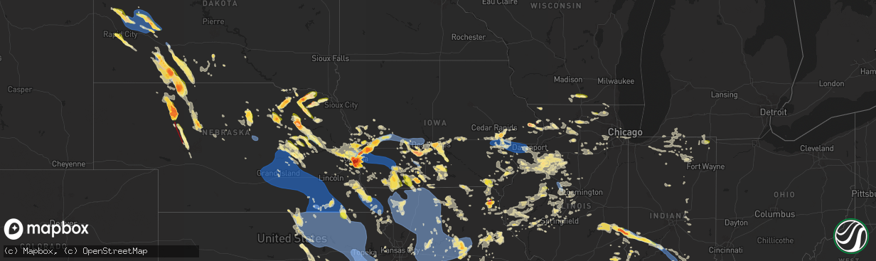
Hail Map in Iowa on June 25, 2024
The weather event in Iowa on June 25, 2024 includes Wind, Hail, and Tornado maps. 22 states and 2,131 cities were impacted and suffered possible damage. The total estimated number of properties impacted is 49,077.
Want more than just the map?
Turn this storm into a full workflow.
- Owner + property data so you know who to knock
- OnDemand branded weather history reports to win the "did we even have hail?" argument
- RoofTrace estimate so reps stop guessing numbers at the door
Bought this map? Upgrade within 7 days and we'll credit the $230. (10-15 min setup call)
Wind
Hail
Tornado
49,077
Estimated number of impacted properties by a 1.00" hail or larger11,202
Estimated number of impacted properties by a 1.75" hail or larger4,158
Estimated number of impacted properties by a 2.50" hail or largerStorm reports in Iowa
Iowa
| Date | Description |
|---|---|
| 06/25/20246:50 PM CDT | A local report indicates 1.00 inch wind near 3 ESE Crescent |
| 06/25/20246:50 PM CDT | Spotter reported brief touchdown north of patterson. |
| 06/25/20246:43 PM CDT | Brief tornado... Dropping up and down near 105th ave and timberview. |
| 06/25/20246:40 PM CDT | Photo on social media. Time estimated from radar data. |
| 06/25/20246:35 PM CDT | Quarter hail and a wind gust of 40 mph. |
| 06/25/20246:34 PM CDT | Public report of quarter hail. |
| 06/25/20246:34 PM CDT | Time estimated from radar. |
| 06/25/20246:33 PM CDT | Time estimated from radar. |
| 06/25/20246:31 PM CDT | Location estimated. |
| 06/25/20246:30 PM CDT | Report relayed by media. Photo confirmed. |
| 06/25/20246:30 PM CDT | Corrects previous hail report from 4 e maquoketa. |
| 06/25/20246:30 PM CDT | Wind has snapped several significant tree branches off. |
| 06/25/20246:15 PM CDT | Report from mping: quarter |
| 06/25/20246:14 PM CDT | Tree fell on an lp tank causing it to leak. Power line was also downed near the tree damage. Time estimated by radar. |
| 06/25/20246:09 PM CDT | A local report indicates 1.25 inch wind near 1 E Hartford |
| 06/25/20245:52 PM CDT | Large tree branches down. Time estimated from radar data. |
| 06/25/20245:50 PM CDT | Time estimated. |
| 06/25/20245:50 PM CDT | Efu landspout tornado touched down in a field resulting in minor crop damage. |
| 06/25/20245:50 PM CDT | Public safety reported quarter size hail northeast of runnells. |
| 06/25/20245:46 PM CDT | Wind damage |
| 06/25/20245:38 PM CDT | Tornado touch down in open field. Pictured in social media. |
| 06/25/20245:30 PM CDT | Nearly stationary efu landspout tornado touched down in a field resulting in minor crop damage. |
| 06/25/20245:28 PM CDT | Multiple reports of a tornado on the ground kicking up dust north of ely. |
| 06/25/20245:25 PM CDT | Nws storm survey determined an ef0 tornado with landspout characteristics occurred with maximum winds near 85 mph. Damage included snapped large tree limbs... Damaged p |
| 06/25/20245:24 PM CDT | Large branch out of the top of a healthy walnut tree. Approximately 25 long and 10+ inch diameter. Time estimated by radar. |
| 06/25/20245:15 PM CDT | Delayed report via two social media reports. |
| 06/25/20245:15 PM CDT | Delayed report via two social media reports. |
| 06/25/20245:11 PM CDT | Tree limbs blown onto highway 64. Time estimated by radar. |
| 06/25/20245:05 PM CDT | Jackson county dispatch reported steel roof was blown off a barn north of preston. There was also damage to a high voltage line reported. Possible tornado damage. Time |
| 06/25/20245:03 PM CDT | Nws storm survey determined an ef1 tornado occurred with maximum winds near 100 mph. This tornado damaged outbuildings... Trees... And crops. |
| 06/25/20244:32 PM CDT | Confirmed tornado by fire chief. Time estimated. |
| 06/25/202410:40 AM CDT | A local report indicates 1.00 inch wind near 2 ESE Bentonsport/Verno |
| 06/24/202411:48 PM CDT | A local report indicates 59 MPH wind near 2 ENE Lamoni |
| 06/24/202410:54 PM CDT | Report from mping: 3-inch tree limbs broken; power poles broken. |
| 06/24/202410:54 PM CDT | Report from mping: 3-inch tree limbs brok |
| 06/24/202410:44 PM CDT | Quarter to 2.25 inch diameter hail. Six minutes of hail from north at 1044 to 1050pm. Small twigs broken off. |
| 06/24/202410:20 PM CDT | 62 mph recorded wind gust on handheld anemometer. Blinding rain sheets. |
| 06/24/202410:17 PM CDT | Report from mping: 1-inch tree limbs broken; shingles blown off. |
| 06/24/202410:05 PM CDT | 3 tree limbs blown down. |
| 06/24/202410:05 PM CDT | Corrects previous tstm wnd dmg report from oakland. 3 very large tree limbs blown down. Numerous other trees blown down. |
| 06/24/202410:04 PM CDT | From a personal weather station. |
| 06/24/202410:02 PM CDT | Report from mping: 3-inch tree limbs broken; power poles broken. |
| 06/24/202410:00 PM CDT | Storm siren pole knocked down and tree limb damage. |
| 06/24/20249:59 PM CDT | From a personal weather station. |
| 06/24/20249:46 PM CDT | Portion of dogwood rd closed due to downed trees and powerlines. |
| 06/24/20249:46 PM CDT | From a personal weather station. |
| 06/24/20249:40 PM CDT | From a personal weather station. |
| 06/24/20249:38 PM CDT | Birdsley rd closed due to downed trees and powerlines. |
| 06/24/20249:03 PM CDT | A local report indicates 1.00 inch wind near Audubon |
| 06/24/20248:50 PM CDT | Measured by personal weather station. |
| 06/24/20248:49 PM CDT | Lawn furniture being tossed around. Also very heavy rain. |
| 06/24/20248:34 PM CDT | Several trees and power lines down. Time estimated by radar. |
| 06/24/20248:15 PM CDT | 4 inch tree branch downed by storm winds. |
| 06/24/20248:14 PM CDT | Report from mping: ping pong ball |
| 06/24/20248:06 PM CDT | A 72 mph wind gust was measured on a personal weather station 2 miles east of harlan. |
| 06/24/20248:06 PM CDT | A 72 mph wind gust was measured on a personal weather station 2 miles east of harlan. |
| 06/24/20248:05 PM CDT | A local report indicates 1.75 inch wind near Harlan |
| 06/24/20248:03 PM CDT | A 62 mph wind gust was recorded on a personal weather station on the northwest side of harlan. |
| 06/24/20248:00 PM CDT | A local report indicates 1.50 inch wind near Missouri Valley |
| 06/24/20248:00 PM CDT | From who tv. |
| 06/24/20247:58 PM CDT | Public reported golf ball sized hail on the northern edge of winterset. Submitted picture via social media. |
| 06/24/20247:57 PM CDT | Ping pong hail in winterset. |
| 06/24/20247:56 PM CDT | A local report indicates 2.50 inch wind near 5 S Earlham |
| 06/24/20247:54 PM CDT | From who tv viewer. |
| 06/24/20247:40 PM CDT | A local report indicates 1.00 inch wind near 1 ENE Shelby |
| 06/24/20247:40 PM CDT | Measured from equipment on top of the car. Location of gust is estimated. |
| 06/24/20247:39 PM CDT | Estimated thunderstorm wind gust. |
| 06/24/20247:35 PM CDT | Estimated thunderstorm wind gusts. Location of the event is estimated. |
| 06/24/20247:35 PM CDT | Estimated thunderstorm wind gust. |
| 06/24/20247:35 PM CDT | Widespread tree limbs down in muscatine as well as power poles down. |
| 06/24/20247:30 PM CDT | 5 large trees and many branches downed at saulsbury bridge recreation area. One tree took down a powerline. Time estimated by radar. |
| 06/24/20247:20 PM CDT | Relay of a public report of dime to quarter size hail southeast of keosauqua. |
| 06/24/20247:18 PM CDT | Time estimated from radar. |
| 06/24/20247:06 PM CDT | Power lines down with power outages around dodge street. Time estimated from radar. |
| 06/24/20247:04 PM CDT | From woi tv/local 5. |
| 06/24/20247:03 PM CDT | Asos station kiow iowa city arpt. |
| 06/24/20247:02 PM CDT | Report from mping: quarter |
| 06/24/20247:02 PM CDT | A local report indicates 1.00 inch wind near 1 E North Liberty |
| 06/24/20247:00 PM CDT | Em relayed a report of a window blown out of a home. Rain spilled through the window and flooded the basement. |
All States Impacted by Hail Map on June 25, 2024
Cities Impacted by Hail Map on June 25, 2024
- Whitehall, MI
- Holton, MI
- Muskegon, MI
- Twin Lake, MI
- Montague, MI
- Newaygo, MI
- Fremont, MI
- Grant, MI
- Conklin, MI
- Fenwick, MI
- Rockford, MI
- Fruitport, MI
- Ravenna, MI
- Sparta, MI
- Kent City, MI
- Greenville, MI
- Casnovia, MI
- Sand Lake, MI
- Bailey, MI
- Cedar Springs, MI
- Gowen, MI
- Lowell, MI
- Wayland, MI
- Saugatuck, MI
- Nunica, MI
- Marne, MI
- Hopkins, MI
- Zeeland, MI
- Orleans, MI
- Fennville, MI
- Allendale, MI
- Grandville, MI
- Jenison, MI
- West Olive, MI
- Wyoming, MI
- Caledonia, MI
- Spring Lake, MI
- Dorr, MI
- Byron Center, MI
- Holland, MI
- Allegan, MI
- Belmont, MI
- Grand Rapids, MI
- Comstock Park, MI
- Grand Haven, MI
- Coopersville, MI
- Macatawa, MI
- Belding, MI
- Hudsonville, MI
- Hamilton, MI
- Ada, MI
- Saranac, MI
- Freeport, MI
- Alto, MI
- Ionia, MI
- Lake Odessa, MI
- Middleville, MI
- Portland, MI
- Clarksville, MI
- Hastings, MI
- Shelbyville, MI
- Thomson, IL
- Mount Carroll, IL
- West Branch, IA
- Tipton, IA
- Monroe Center, IL
- Davis Junction, IL
- Kewanee, IL
- Annawan, IL
- Sheffield, IL
- Earlville, IL
- Sterling, IL
- Atalissa, IA
- Chadwick, IL
- Lanark, IL
- Cambridge, IL
- Atkinson, IL
- Geneseo, IL
- Oregon, IL
- Leaf River, IL
- Stillman Valley, IL
- Lindenwood, IL
- Kirkland, IL
- Esmond, IL
- Athens, MI
- Union City, MI
- East Leroy, MI
- Marcellus, MI
- Decatur, MI
- Schoolcraft, MI
- Lawton, MI
- Riverside, IA
- North Aurora, IL
- Aurora, IL
- Watervliet, MI
- Kalona, IA
- Wellman, IA
- Bangor, MI
- Covert, MI
- Milledgeville, IL
- Mchenry, IL
- Polo, IL
- Mount Morris, IL
- Forreston, IL
- Buda, IL
- Kingston, IL
- Chicago, IL
- Lone Tree, IA
- Woodstock, IL
- Galva, IL
- Jackson, MI
- West Liberty, IA
- Grass Lake, MI
- Bennett, IA
- Union, IL
- Marengo, IL
- Huntley, IL
- Wonder Lake, IL
- Dixon, IL
- Neponset, IL
- Sherwood, MI
- Mineral, IL
- Wyanet, IL
- Murray, IA
- Sycamore, IL
- Clare, IL
- Byron, IL
- Plainfield, IL
- Naperville, IL
- Oswego, IL
- Yorkville, IL
- Coloma, MI
- Hartford, MI
- Leland, IL
- Sherrard, IL
- Bishop Hill, IL
- Eau Claire, MI
- Sodus, MI
- Genoa, IL
- Manchester, MI
- Crystal Lake, IL
- Chelsea, MI
- Clarklake, MI
- Brooklyn, MI
- Bradford, IL
- Altona, IL
- Tiskilwa, IL
- Toulon, IL
- Woodhull, IL
- Dowagiac, MI
- Berrien Center, MI
- Franklin Grove, IL
- La Grange, IL
- Amboy, IL
- La Moille, IL
- Sublette, IL
- West Brooklyn, IL
- Morrison, IL
- Cassopolis, MI
- Compton, IL
- Spring Grove, IL
- Iowa City, IA
- Bronson, MI
- Holcomb, IL
- Benton Harbor, MI
- Addison, MI
- Cement City, MI
- Burbank, IL
- Justice, IL
- Willow Springs, IL
- Vandalia, MI
- Rochelle, IL
- Niles, MI
- Berrien Springs, MI
- Island Lake, IL
- Antioch, IL
- Alexis, IL
- Lynn Center, IL
- Newark, IL
- Salem, WI
- Trevor, WI
- Wauconda, IL
- Round Lake, IL
- Cary, IL
- Grayslake, IL
- Barrington, IL
- Ashton, IL
- Thayer, IA
- Steward, IL
- Bolingbrook, IL
- Twin Lakes, WI
- Richmond, IL
- Orland, IN
- Howe, IN
- Jones, MI
- White Pigeon, MI
- Oneida, IL
- New Boston, IL
- Joy, IL
- Seaton, IL
- Edwardsburg, MI
- Evergreen Park, IL
- Keota, IA
- Aledo, IL
- Little York, IL
- Shorewood, IL
- Minooka, IL
- Union, MI
- Lagrange, IN
- La Fayette, IL
- Mendota, IL
- Bristol, IN
- Joliet, IL
- Galesburg, IL
- Rio, IL
- Lake Villa, IL
- West Chester, IA
- Washington, IA
- Angola, IN
- Buchanan, MI
- Henderson, IL
- Wataga, IL
- Orion, IL
- Walkerton, IN
- Gerlaw, IL
- Ottawa, IL
- Wolcottville, IN
- La Salle, IL
- Peru, IL
- Utica, IL
- Serena, IL
- Hudson, IN
- South Bend, IN
- North Liberty, IN
- Wauseon, OH
- Delta, OH
- Wyoming, IL
- Elkhart, IN
- Osceola, IN
- Granger, IN
- Mishawaka, IN
- Victoria, IL
- Goshen, IN
- Seneca, IL
- Wedron, IL
- Wakarusa, IN
- Marseilles, IL
- Speer, IL
- Middlebury, IN
- Alpha, IL
- Pleasant Lake, IN
- Lakeville, IN
- Bremen, IN
- Ligonier, IN
- Hamlet, IN
- Union Mills, IN
- Westville, IN
- Kingsford Heights, IN
- La Porte, IN
- Davis City, IA
- Williamsfield, IL
- Monmouth, IL
- North Henderson, IL
- Nappanee, IN
- New Paris, IN
- Leon, IA
- Lineville, IA
- Princeville, IL
- Oquawka, IL
- Knoxville, IL
- Syracuse, IN
- Millersburg, IN
- Grovertown, IN
- Plymouth, IN
- Laura, IL
- Leesburg, IN
- Milford, IN
- Cromwell, IN
- Etna Green, IN
- Warsaw, IN
- Dahinda, IL
- East Galesburg, IL
- Brimfield, IL
- Rochester, IN
- Culver, IN
- Pierceton, IN
- Winona Lake, IN
- Larwill, IN
- Columbia City, IN
- North Webster, IN
- Elmwood, IL
- Cainsville, MO
- El Paso, IL
- Roanoke, IL
- Benson, IL
- Mercer, MO
- Gilson, IL
- La Fontaine, IN
- Wabash, IN
- Pekin, IL
- Keosauqua, IA
- Deer Creek, IL
- Eureka, IL
- Washington, IL
- Morton, IL
- Walton, IN
- Galveston, IN
- Logansport, IN
- East Peoria, IL
- Metamora, IL
- South Pekin, IL
- Tremont, IL
- Green Valley, IL
- Peoria, IL
- Groveland, IL
- Creve Coeur, IL
- Peoria Heights, IL
- Wapakoneta, OH
- Bonaparte, IA
- Fairview, IL
- Canton, IL
- Ellisville, IL
- Smithfield, IL
- Anna, OH
- Jackson Center, OH
- Maplewood, OH
- Sidney, OH
- Camden, IN
- Delavan, IL
- Port Jefferson, OH
- Botkins, OH
- Quincy, OH
- De Graff, OH
- Topeka, IL
- Havana, IL
- Stanford, IL
- Minier, IL
- Cuba, IL
- Armington, IL
- Milton, IA
- Douds, IA
- Manito, IL
- Forest City, IL
- Bellefontaine, OH
- Lewistown, OH
- Huntsville, OH
- Table Grove, IL
- Adair, IL
- Summitville, IN
- Alexandria, IN
- Kahoka, MO
- Farmington, IA
- Mount Sterling, IA
- West Liberty, OH
- Hopedale, IL
- Lewistown, IL
- Vermont, IL
- Ipava, IL
- McLean, IL
- Easton, IL
- Mason City, IL
- Zanesfield, OH
- Urbana, OH
- San Jose, IL
- New Holland, IL
- Bryant, IL
- Pendleton, IN
- Emden, IL
- Atlanta, IL
- Rushville, IL
- Industry, IL
- Liverpool, IL
- Fortville, IN
- Greenfield, IN
- Macomb, IL
- Hartsburg, IL
- Plymouth, IL
- Littleton, IL
- Augusta, IL
- Kenney, IL
- Lincoln, IL
- Waterloo, IN
- Ashley, IN
- London, OH
- Maroa, IL
- Chestnut, IL
- Charlottesville, IN
- Camden, IL
- Huntsville, IL
- Mount Pulaski, IL
- Carthage, IN
- Morristown, IN
- Arlington, IN
- Downing, MO
- Argenta, IL
- Latham, IL
- Arcola, IL
- Cerro Gordo, IL
- Milmine, IL
- La Prairie, IL
- Arthur, IL
- Tuscola, IL
- Petersburg, IL
- Greenview, IL
- Golden, IL
- Humboldt, IL
- Shelbyville, IN
- Waldron, IN
- Manilla, IN
- Athens, IL
- Clinton, IL
- Charleston, IL
- Brocton, IL
- Sullivan, IL
- Hindsboro, IL
- Mattoon, IL
- Oakland, IL
- Oreana, IL
- Monticello, IL
- Bement, IL
- Cisco, IL
- Timewell, IL
- Tallula, IL
- Beason, IL
- Oakford, IL
- Newman, IL
- Glasford, IL
- Astoria, IL
- Browning, IL
- Mount Sterling, IL
- Saint David, IL
- Kansas, IL
- Paris, IL
- Chillicothe, OH
- Frederick, IL
- Ashmore, IL
- Redmon, IL
- Ashland, IL
- Martinsville, IL
- Dennison, IL
- West Terre Haute, IN
- Quincy, IL
- Marshall, IL
- Meredosia, IL
- Jacksonville, IL
- Maywood, MO
- Durham, MO
- Cantrall, IL
- Springfield, IL
- Chapin, IL
- La Grange, MO
- Ewing, MO
- Mendon, IL
- Terre Haute, IN
- Winchester, IL
- Bluffs, IL
- Clayton, IL
- Camp Point, IL
- Fowler, IL
- Greenup, IL
- Sherman, IL
- Concord, IL
- Arenzville, IL
- Brazil, IN
- Riley, IN
- Taylor, MO
- Staunton, IN
- Farmersburg, IN
- Cory, IN
- Pleasant Plains, IL
- Cordesville, SC
- Annapolis, IL
- Willow Hill, IL
- Oblong, IL
- Buffalo, IL
- Paloma, IL
- Coatsburg, IL
- Centerpoint, IN
- Clay City, IN
- Bowling Green, IN
- Coal City, IN
- West Liberty, IL
- North Vernon, IN
- Dundas, IL
- Seymour, IN
- Versailles, IL
- Stoy, IL
- Robinson, IL
- Sullivan, IN
- Liberty, IL
- Alexander, IL
- New Berlin, IL
- Shelburn, IN
- Freedom, IN
- Sumner, IL
- Patricksburg, IN
- Spencer, IN
- Poland, IN
- Carlisle, IN
- Merom, IN
- Claremont, IL
- Flat Rock, IL
- Olney, IL
- Xenia, IL
- Dugger, IN
- Linton, IN
- Noble, IL
- Dawson, IL
- Riverton, IL
- Commiskey, IN
- Barry, IL
- Pittsfield, IL
- Brownstown, IN
- Crothersville, IN
- Bloomington, IN
- Kinderhook, IL
- Oaktown, IN
- Lawrenceville, IL
- Palestine, IL
- New Canton, IL
- Flora, IL
- Rinard, IL
- Hull, IL
- Rochester, IL
- Bridgeport, IL
- Baylis, IL
- New London, MO
- Bowman, SC
- Plainville, IL
- Clay City, IL
- Cisne, IL
- Green Cove Springs, FL
- West Union, IL
- Mount Erie, IL
- New Salem, IL
- Griggsville, IL
- Chambersburg, IL
- Calhoun, IL
- Elnora, IN
- West Salem, IL
- Washington, IN
- Ellettsville, IN
- Solsberry, IN
- Montgomery, IN
- Plainville, IN
- Seligman, AZ
- Parkersburg, IL
- Vincennes, IN
- Monroe City, IN
- Wheatland, IN
- Nashville, IN
- Saint Francisville, IL
- Murrayville, IL
- Mount Carmel, IL
- Rockport, IL
- Bicknell, IN
- Edwardsport, IN
- Vermilion, IL
- Gosport, IN
- Norman, IN
- Heltonville, IN
- Medora, IN
- Freetown, IN
- Vallonia, IN
- Pleasant Hill, IL
- Columbus, IN
- Ava, MO
- Squires, MO
- Geff, IL
- O'Brien, FL
- Sims, IL
- Summerton, SC
- Hazleton, IN
- Decker, IN
- Zolfo Springs, FL
- Vale, SD
- Newell, SD
- Waverly, IL
- Young, AZ
- Campbellsburg, IN
- Franklin, IL
- Golden Gate, IL
- Fairfield, IL
- Nisland, SD
- Francisco, IN
- Patoka, IN
- Payson, AZ
- Loami, IL
- Sturgis, SD
- Chatham, IL
- Hackberry, AZ
- Princeton, IN
- Jasper, IN
- Velpen, IN
- Huntingburg, IN
- Johnsonville, IL
- Albion, IL
- Palmyra, IL
- Paris Crossing, IN
- Austin, IN
- Bluford, IL
- New Carlisle, IN
- Galien, MI
- Enning, SD
- Union Center, SD
- Miles, IA
- Sabula, IA
- Louisiana, MO
- Ellery, IL
- Newton, IA
- McAlpin, FL
- Lexington, IN
- Scottsburg, IN
- Deputy, IN
- Stoutsville, MO
- Live Oak, FL
- Center, MO
- New Underwood, SD
- Vandalia, MO
- Frankford, MO
- Show Low, AZ
- Slater, MO
- Armstrong, MO
- Glasgow, MO
- Salisbury, MO
- Howes, SD
- Tallahassee, FL
- White Owl, SD
- Preston, IA
- Curryville, MO
- Perry, MO
- Fayette, MO
- Wasta, SD
- Santa Fe, MO
- Ridgeville, SC
- Gilliam, MO
- Walterboro, SC
- Amite, LA
- Greensburg, LA
- Higbee, MO
- Omaha, NE
- Council Bluffs, IA
- Shannon, IL
- Grinnell, IA
- Wall, SD
- Colfax, IA
- Summerville, SC
- Madison, MO
- Kellogg, IA
- Clinton, IA
- Fulton, IL
- Louisville, KY
- Sedona, AZ
- Saint Louis, MO
- Owanka, SD
- Box Elder, SD
- Bellevue, NE
- Garden Prairie, IL
- Harvard, IL
- Holliday, MO
- Paris, MO
- Monroe, IA
- Runnells, IA
- Mitchellville, IA
- Prairie City, IA
- Rocheport, MO
- Malcom, IA
- Marland, OK
- Gregory, SD
- Mexico, MO
- Harrisburg, MO
- Clark, MO
- Sturgeon, MO
- Ponca City, OK
- Coulterville, IL
- Mechanicsville, IA
- Winfield, KS
- Centralia, MO
- Laddonia, MO
- Thompson, MO
- Quinn, SD
- Philip, SD
- Ely, IA
- Bassett, NE
- Arkansas City, KS
- New Franklin, MO
- Kaw City, OK
- Belle, MO
- Offutt Afb, NE
- Fernley, NV
- Silver Springs, NV
- Farber, MO
- Plainview, NE
- Neligh, NE
- Lisbon, IA
- Boonville, MO
- Meadow Grove, NE
- Brooklyn, IA
- Pierce, NE
- Ewing, NE
- Inman, NE
- Stuart, NE
- Atkinson, NE
- Amelia, NE
- La Vista, NE
- Papillion, NE
- Pacific Junction, IA
- Franklin, MO
- Potosi, MO
- Belvidere, IL
- Wellington, KS
- Bryant, IA
- Glenwood, IA
- Rapid City, SD
- Tilden, NE
- Battle Creek, NE
- Delmar, IA
- Maquoketa, IA
- Newkirk, OK
- Burwell, NE
- Belle Plaine, KS
- Rimrock, AZ
- Auxvasse, MO
- Imperial, MO
- Barnhart, MO
- Mulvane, KS
- Udall, KS
- Hermosa, SD
- Caputa, SD
- Clearwater, NE
- Hartford, IA
- Swan, IA
- Carlisle, IA
- Pleasantville, IA
- Ackworth, IA
- Miami, TX
- Clarence, IA
- Charlotte, IA
- Hillsboro, MO
- Mount Vernon, IL
- Ralston, OK
- Shidler, OK
- Burbank, OK
- New Haven, MO
- Stockport, IA
- Hampshire, IL
- Warrenton, MO
- Goose Lake, IA
- Scenic, SD
- Kyle, SD
- Columbia, IL
- Kingdom City, MO
- Fulton, MO
- Palmyra, MO
- Valentine, NE
- Crescent, IA
- Seneca, NE
- Kadoka, SD
- Interior, SD
- Wanblee, SD
- Lewistown, MO
- Mullen, NE
- Pleasant Hill, IA
- Des Moines, IA
- Corydon, KY
- Henderson, KY
- Plattsmouth, NE
- Panhandle, TX
- Amarillo, TX
- Portales, NM
- Carter Lake, IA
- Norfolk, NE
- Norwalk, IA
- Altoona, IA
- Red Rock, OK
- Pawnee, OK
- Berger, MO
- Hermann, MO
- Cumming, IA
- Mclean, NE
- Osmond, NE
- De Soto, MO
- Orange City, FL
- Stanwood, IA
- Indianola, IA
- Oxford, KS
- Leslie, MO
- Blackwell, MO
- Fletcher, MO
- Solon, IA
- Allen, SD
- Mount Vernon, IA
- Danville, IA
- Prole, IA
- Madison, NE
- North Liberty, IA
- Festus, MO
- Owensville, MO
- Marathon, TX
- Randolph, NE
- Coleridge, NE
- La Belle, MO
- Knox City, MO
- Honey Creek, IA
- Underwood, IA
- Coralville, IA
- Debary, FL
- Neola, IA
- Martin, SD
- Magnet, NE
- Hartington, NE
- New London, IA
- Chariton, IA
- Lacona, IA
- Knoxville, IA
- De Witt, IA
- Williamstown, MO
- Monticello, MO
- Perry, OK
- Pawhuska, OK
- Russell, IA
- New Windsor, IL
- Tiffin, IA
- Lucas, IA
- Oxford, IA
- Pevely, MO
- Hills, IA
- Van Meter, IA
- Belle Rive, IL
- Viola, IL
- Bloomfield, NE
- Billings, OK
- Minden, IA
- Persia, IA
- Shelby, IA
- Avoca, IA
- Melcher Dallas, IA
- Columbia, IA
- Wyaconda, MO
- Morrison, OK
- Canton, MO
- Springfield, NE
- Owensboro, KY
- West Burlington, IA
- Yarmouth, IA
- Burlington, IA
- Sperry, IA
- Johnstown, NE
- Nichols, IA
- Sebree, KY
- Robards, KY
- Luray, MO
- Genoa City, WI
- San Manuel, AZ
- French Village, MO
- Tuthill, SD
- Merriman, NE
- Cody, NE
- Claude, TX
- Canyon, TX
- Stanton, NE
- Clarkson, NE
- Creston, NE
- Leigh, NE
- Long Valley, SD
- Causey, NM
- Calhoun, KY
- Saint Patrick, MO
- Blackwell, OK
- Slaughters, KY
- Dixon, KY
- Sparland, IL
- Farmington, MO
- Sainte Genevieve, MO
- South Amana, IA
- Homestead, IA
- Marengo, IA
- Sparks, NV
- Mineral Point, MO
- Putnam, IL
- Henry, IL
- Madisonville, KY
- Nebo, KY
- Van Buren, MO
- Ellington, MO
- Irondale, MO
- Lindsay, NE
- Saint Edward, NE
- Humphrey, NE
- Monroe, NE
- Wausa, NE
- Creighton, NE
- Norris, SD
- Page, NE
- Orchard, NE
- Orlando, OK
- Stillwater, OK
- Laurel, NE
- Newcastle, NE
- Ponca, NE
- Muscatine, IA
- Wilton, IA
- Durant, IA
- Moscow, IA
- Illinois City, IL
- Stockton, IA
- Walcott, IA
- Davenport, IA
- Blue Grass, IA
- Reynolds, IL
- Andalusia, IL
- Buffalo, IA
- Montpelier, IA
- Taylor Ridge, IL
- Milan, IL
- Rock Island, IL
- Missouri Valley, IA
- Bettendorf, IA
- Logan, IA
- Janesville, WI
- Brodhead, WI
- Sedan, KS
- Bonne Terre, MO
- Park Hills, MO
- Winner, SD
- Corydon, IA
- Manitou, KY
- Pampa, TX
- Vienna, MO
- Cedar Vale, KS
- Tonkawa, OK
- Keithsburg, IL
- Derby, IA
- Melrose, IA
- Bloomsdale, MO
- Harlan, IA
- Schuyler, NE
- Evansville, WI
- Crofton, NE
- Whitman, NE
- Milton, WI
- Avalon, WI
- Whitewater, WI
- Darien, WI
- Winnetoon, NE
- Platte Center, NE
- Winfield, IA
- Olds, IA
- Crawfordsville, IA
- Mount Pleasant, IA
- Osco, IL
- Wood, SD
- Ladora, IA
- Lovington, NM
- Parmelee, SD
- White River, SD
- Adel, IA
- Earlham, IA
- Winterset, IA
- Montezuma, IA
- West Des Moines, IA
- Saint Charles, IA
- Bevington, IA
- Truro, IA
- Williamsburg, IA
- Rogers, NM
- Cadet, MO
- New Virginia, IA
- Kirkwood, IL
- Hanson, KY
- Edelstein, IL
- Chillicothe, IL
- Coal Valley, IL
- Footville, WI
- Cantril, IA
- Nashville, IL
- Patterson, IA
- Woodbine, IA
- Portsmouth, IA
- Kirkman, IA
- Irwin, IA
- Grand River, IA
- Van Wert, IA
- Mulhall, OK
- Perkins, OK
- Coyle, OK
- Elk City, KS
- Modale, IA
- Saint Francis, SD
- Orfordville, WI
- Lowpoint, IL
- Peru, IA
- Lorimor, IA
- Fort Calhoun, NE
- Blair, NE
- Galena, IL
- Scales Mound, IL
- Elizabeth, IL
- Panama, IA
- Ophiem, IL
- Ashley, IL
- Du Bois, IL
- Yates City, IL
- Vichy, MO
- Menlo, IA
- Greenfield, IA
- Kimballton, IA
- Audubon, IA
- Manning, IA
- Fordyce, NE
- Hoskins, NE
- Verdigre, NE
- Havana, KS
- Independence, KS
- Covington, OK
- Cameron, IL
- Magnolia, IA
- Farmington, IL
- Hancock, IA
- Washburn, IL
- Maquon, IL
- Royal, NE
- Richwoods, MO
- Swisher, IA
- Mediapolis, IA
- Piedmont, MO
- Mill Spring, MO
- Middletown, IA
- Patterson, MO
- Garber, OK
- Mission, SD
- Mount Union, IA
- Tryon, OK
- Meridian, OK
- Wellston, OK
- Guthrie, OK
- Happy, TX
- Tulia, TX
- Pond Creek, OK
- Arbela, MO
- Fleming Island, FL
- Jacksonville, FL
- Westphalia, IA
- Earling, IA
- Sharon, OK
- Kilgore, NE
- McClelland, IA
- De Soto, IA
- Marshall, OK
- Douglas, OK
- Lucien, OK
- Saint Mary, MO
- Stuart, IA
- Guthrie Center, IA
- Panora, IA
- Winside, NE
- Wynot, NE
- Saint Helena, NE
- Luther, OK
- Carney, OK
- Dunlap, IA
- Hunter, OK
- Gordon, NE
- London Mills, IL
- Conesville, IA
- Longton, KS
- Hennessey, OK
- Denison, IA
- Ainsworth, IA
- Columbus Junction, IA
- Bourbon, MO
- Mapleton, IL
- Hanna City, IL
- Hamlin, IA
- Coon Rapids, IA
- Adair, IA
- Bison, OK
- Crescent, OK
- Kingfisher, OK
- Cashion, OK
- Tryon, NE
- Little Sioux, IA
- Onawa, IA
- Pisgah, IA
- Soldier, IA
- Moorhead, IA
- Cottageville, SC
- Salem, IA
- Manilla, IA
- Afton, IA
- Wayne, NE
- Pilger, NE
- Pinckneyville, IL
- Dixon, NE
- Letts, IA
- Osceola, IA
- Mondamin, IA
- Tekamah, NE
- Bennington, NE
- Dow City, IA
- Ute, IA
- Rogers, NE
- Dodge, NE
- Howells, NE
- Valley, NE
- Elkhorn, NE
- Waterloo, NE
- Linden, IA
- Redfield, IA
- Moulton, IA
- Coatsville, MO
- Bloomfield, IA
- Dexter, IA
- Ellston, IA
- Nash, OK
- West Point, IA
- Wooldridge, MO
- Jamestown, MO
- Cherryvale, KS
- Columbia, MO
- Arlington, NE
- Kennard, NE
- Arnett, OK
- Cedar Bluffs, NE
- Morse Bluff, NE
- North Bend, NE
- Lancaster, MO
- Charter Oak, IA
- Piedmont, OK
- Edmond, OK
- Arcadia, OK
- Oakland, IA
- Treynor, IA
- Macedonia, IA
- Silver City, IA
- Carson, IA
- Sutherland, NE
- Vail, IA
- Westside, IA
- Casey, IA
- Enid, OK
- Niobrara, NE
- Shannon City, IA
- Thedford, NE
- Creston, IA
- Wapello, IA
- Fontanelle, IA
- Queen City, MO
- Kiron, IA
- Deloit, IA
- Diagonal, IA
- Kilbourne, IL
- Weldon, IA
- Decatur, IA
- Gerald, MO
- Lenox, IA
- Dimmitt, TX
- Springfield, SD
- Newport, NE
- Orient, IA
- Hereford, TX
- Minburn, IA
- Dallas Center, IA
- Waukee, IA
- Oklahoma City, OK
- Bethany, OK
- Yukon, OK
- Choctaw, OK
- Jones, OK
- Spencer, OK
- Albion, NE
- Newman Grove, NE
- Emerson, IA
- Red Oak, IA
- Griswold, IA
- Elliott, IA
- Henderson, IA
- Lewis, IA
- Cumberland, IA
- Atlantic, IA
- Villisca, IA
- Grant, IA
- New Bloomfield, MO
- Prescott, IA
- Macksburg, IA
- Elgin, NE
- Nazareth, TX
- Corning, IA
- Donnellson, IA
- Bisbee, AZ
- Hillsboro, IA
- Martensdale, IA
- Washington, NE
- Hartsburg, MO
- Purdum, NE
- Williamson, IA
- Milo, IA
- Montgomery City, MO
- Williamsburg, MO
- Norman, OK
- Columbus, NE
- Center, NE
- Mount Ayr, IA
- Kellerton, IA
- Murphysboro, IL
- Ava, IL
- Ellsinore, MO
- Morning Sun, IA
- Tingley, IA
- Newark, MO
- Genoa, NE
- Carbon, IA
- Massena, IA
- Nodaway, IA
- Bridgewater, IA
- Urbandale, IA
- Clive, IA
- Grimes, IA
- Harrah, OK
- Mcloud, OK
- Newalla, OK
- Hart, TX
- Clearfield, IA
- Jefferson City, MO
- Lamoni, IA
- Alexandria, MO
- Ames, NE
- Ashland, MO
- Fredericktown, MO
- Fremont, NE
- Gravity, IA
- Yutan, NE
- Colon, NE
- Bethel, MO
- Benton, IA
- Blockton, IA
- Des Arc, MO
- Annapolis, MO
- New Market, IA
- Bedford, IA
- Sharpsburg, IA
- Boys Town, NE
- Shawnee, OK
- Tecumseh, OK
- Noble, OK
- Wanette, OK
- Macomb, OK
- Lexington, OK
- Clarinda, IA
- Avon, SD
- Millerton, IA
- Shambaugh, IA
- Lovilia, IA
- Plano, IA
- Promise City, IA
- Marquand, MO
- Schleswig, IA
- Evansville, IN
- Nebraska City, NE
- Oneill, NE
- Chambers, NE
- Talmage, NE
- Nickerson, NE
- Cedar Rapids, NE
- Redding, IA
- Brock, NE
- Herman, NE
- Sheridan, MO
- Hopkins, MO
- Salem, KY
- Marion, KY
- Julian, NE
- Peru, NE
- Humeston, IA
- Fullerton, NE
- Hagarville, AR
- Lamar, AR
- Hershey, NE
- Hatfield, MO
- Patton, MO
- Garden Grove, IA
- Perryville, MO
- Belgrade, NE
- Malvern, IA
- Cape Girardeau, MO
- Chaffee, MO
- Ord, NE
- Elyria, NE
- Silver Creek, NE
- Osceola, NE
- Clarks, NE
- Wolbach, NE
- Auburn, NE
- Brownville, NE
- Stanberry, MO
- Primrose, NE
- Shelbina, MO
- Grant City, MO
- Fairfax, MO
- Rock Port, MO
- Denver, MO
- Worth, MO
- Pickering, MO
- Parnell, MO
- Maryville, MO
- Ravenwood, MO
- Barnard, MO
- Gentry, MO
- Conception Junction, MO
- Skidmore, MO
- Graham, MO
- Bolckow, MO
- Conception, MO
- Clyde, MO
- Guilford, MO
- Martinsville, MO
- Darlington, MO
- Rea, MO
- New Hampton, MO
- McFall, MO
- Rosendale, MO
- Albany, MO
- Bethany, MO
- King City, MO
- Eagleville, MO
- Ridgeway, MO
- Blythedale, MO
- Princeton, MO
- Savannah, MO
- Union Star, MO
- Dunbar, NE
- Milan, MO
- Pollock, MO
- Kremlin, OK
- Green City, MO
- Lorton, NE
- Randolph, IA
- Unionville, MO
- Farragut, IA
- Glenwood, MO
- Payson, IL
- Nemaha, NE
- Kirksville, MO
- Brashear, MO
- Amity, MO
- Maysville, MO
- Central City, NE
- Essex, IA
- Shenandoah, IA
- Greenville, MO
- Imogene, IA
- Avoca, NE
- Riverton, IA
- Sidney, IA
- Wadesville, IN
- Craig, MO
- Oakdale, NE
- Falls City, NE
- Shubert, NE
- Verdon, NE
- Stella, NE
- Stromsburg, NE
- Polk, NE
- Hordville, NE
- Ashland, NE
- Petersburg, NE
- Otoe, NE
- Saint Paul, NE
- Palmer, NE
- Archer, NE
- Chapman, NE
- Boelus, NE
- Saint Libory, NE
- Dannebrog, NE
- Cairo, NE
- Rockville, NE
- Marquette, NE
- Wood River, NE
- Gibbon, NE
- Grand Island, NE
- Shelton, NE
- Ravenna, NE
- Phillips, NE
- Alda, NE
- Kenesaw, NE
- Juniata, NE
- Aurora, NE
- Hastings, NE
- Doniphan, NE
- Trumbull, NE
- Giltner, NE
- Maitland, MO
- Oregon, MO
- White Cloud, KS
- Forest City, MO
- Mound City, MO
- Rulo, NE
- Coffey, MO
- Gilman City, MO
- Humphreys, MO
- Jamesport, MO
- Galt, MO
- Pattonsburg, MO
- Spickard, MO
- Jameson, MO
- Trenton, MO
- Harris, MO
- Laredo, MO
- Altamont, MO
- Helena, MO
- Gallatin, MO
- Browning, MO
- Easton, MO
- Clarksdale, MO
- Weatherby, MO
- Cameron, MO
- Saint Joseph, MO
- Winston, MO
- Osborn, MO
- Stewartsville, MO
- Cosby, MO
- Ewing, IL
- Macedonia, IL
- Breckenridge, MO
- Hamilton, MO
- Chula, MO
- Chillicothe, MO
- Lock Springs, MO
- Kidder, MO
- Wheeling, MO
- Garland, NE
- Malcolm, NE
- Pleasant Dale, NE
- Benedict, NE
- Grandin, MO
- Greenwood, NE
- Neodesha, KS
- Valles Mines, MO
- Syracuse, NE
- Palmyra, NE
- Unadilla, NE
- Taylor, NE
- Lincoln, NE
- Saronville, NE
- Bradshaw, NE
- Clay Center, NE
- Hampton, NE
- Sutton, NE
- Harvard, NE
- York, NE
- Inland, NE
- Henderson, NE
- Louisville, NE
- Almo, KY
- Benton, KY
- Hardin, KY
- Dexter, KY
- South Bend, NE
- Murray, NE
- Nehawka, NE
- Memphis, MO
- Gretna, NE
- Naylor, MO
- Success, AR
- Vergennes, IL
- Templeton, IA
- Saint Paul, IA
- Liberty, KS
- Waverly, NE
- Moline, IL
- Amazonia, MO
- Seward, NE
- Milford, NE
- Cordova, NE
- Beaver Crossing, NE
- Exeter, NE
- McCool Junction, NE
- Waco, NE
- Utica, NE
- Friend, NE
- Fairmont, NE
- Dorchester, NE
- Grafton, NE
- Geneva, NE
- Tobias, NE
- Milligan, NE
- Ohiowa, NE
- Linneus, MO
- Meadville, MO
- Mooresville, MO
- Utica, MO
- Plattsburg, MO
- Braymer, MO
- Dawn, MO
- Turney, MO
- Cowgill, MO
- Lawson, MO
- Ludlow, MO
- Kingston, MO
- Polo, MO
- Lathrop, MO
- Wagner, SD
- Whitewater, MO
- Marble Hill, MO
- Burfordville, MO
- Highland, KS
- Troy, KS
- Palmersville, TN
- Fulton, KY
- Sedalia, KY
- Dukedom, TN
- De Soto, IL
- Brunswick, NE
- Vermillion, SD
- Murray, KY
- Green Castle, MO
- Wathena, KS
- Sedgewickville, MO
- Cedar Creek, NE
- Sterling, NE
- Cook, NE
- Robinson, KS
- Doniphan, MO
- Superior, NE
- Daykin, NE
- Byron, NE
- Deshler, NE
- Jackson, MO
- Lost Nation, IA
- Oak Ridge, MO
- Glenallen, MO
- Millersville, MO
- Alexandria, NE
- Chamois, MO
- Rayville, MO
- Hardin, MO
- Carrollton, MO
- Tina, MO
- Bogard, MO
- Norborne, MO
- Richmond, MO
- Hale, MO
- Bosworth, MO
- Odell, NE
- Crete, NE
- Clatonia, NE
- Cortland, NE
- Beatrice, NE
- Swanton, NE
- Virginia, NE
- Filley, NE
- Blue Springs, NE
- Wymore, NE
- Wilber, NE
- Hallam, NE
- De Witt, NE
- Plymouth, NE
- Pickrell, NE
- Western, NE
- Steele City, NE
- Diller, NE
- Jansen, NE
- Fairbury, NE
- Bremen, KS
- Hollenberg, KS
- Barnes, KS
- Hanover, KS
- Marysville, KS
- Greenleaf, KS
- Washington, KS
- Endicott, NE
- Hubbell, NE
- Gilead, NE
- Reynolds, NE
- Hebron, NE
- Narka, KS
- Scandia, KS
- Republic, KS
- Munden, KS
- Norway, KS
- Courtland, KS
- Belleville, KS
- Strang, NE
- Ethel, MO
- Elmer, MO
- Buchanan, TN
- New Concord, KY
- Maynard, AR
- Poplar Bluff, MO
- Williamsville, MO
- Denton, KS
- Mendon, MO
- Tecumseh, NE
- Chester, NE
- Warm Springs, AR
- Atchison, KS
- Jamestown, KS
- Pocahontas, AR
- Mahaska, KS
- Tamms, IL
- Ullin, IL
- Dongola, IL
- Keytesville, MO
- Anna, IL
- Higginsville, MO
- Malta Bend, MO
- Alma, MO
- Marshall, MO
- Dover, MO
- De Witt, MO
- Corder, MO
- Lexington, MO
- Waverly, MO
- Blackburn, MO
- Miami, MO
- Morrowville, KS
- Lewiston, NE
- Home, KS
- Beattie, KS
- Oketo, KS
- Barneston, NE
- Summerfield, KS
- Burchard, NE
- Pawnee City, NE
- Liberty, NE
- Axtell, KS
- Cuba, KS
- Haddam, KS
- Agenda, KS
- Morganville, KS
- Aurora, KS
- Linn, KS
- Blue Rapids, KS
- Concordia, KS
- Clyde, KS
- Clifton, KS
- Frankfort, KS
- Waterville, KS
- Palmer, KS
- Rockwood, IL
- Lodi, MO
- Clubb, MO
- Silva, MO
- Imboden, AR
- S Coffeyville, OK
- Arcadia, MO
- Baileyville, KS
- Erie, KS
- Chanute, KS
- Humboldt, KS
- Neosho Falls, KS
- Colony, KS
- Neelyville, MO
- Dover, TN
- Bevier, MO
- Beech Grove, AR
- Lenapah, OK
- Du Quoin, IL
- Elkville, IL
- Yorktown, IA
- Callao, MO
- Macon, MO
- Peach Orchard, AR
- Delaplaine, AR
- Onaga, KS
- Leonardville, KS
- Olsburg, KS
- Havensville, KS
- Westmoreland, KS
- Clay Center, KS
- Centralia, KS
- Vermillion, KS
- Randolph, KS
- Green, KS
- Corning, KS
- Miltonvale, KS
- Triplett, MO
- Huntsville, MO
- Dalton, MO
- Moberly, MO
- Clifton Hill, MO
- Brunswick, MO
- Nelson, MO
- Henrietta, MO
- Blackwater, MO
- Camden, MO
- Mayview, MO
- Concordia, MO
- Sweet Springs, MO
- Napoleon, MO
- Sibley, MO
- Oak Grove, MO
- Odessa, MO
- Orrick, MO
- Arrow Rock, MO
- Wellington, MO
- Bates City, MO
- Lone Jack, MO
- Houstonia, MO
- La Monte, MO
- Kingsville, MO
- Holden, MO
- Centerview, MO
- Knob Noster, MO
- Warrensburg, MO
- Pilot Grove, MO
- Hughesville, MO
- Sedalia, MO
- Sabetha, KS
- Wetmore, KS
- Seneca, KS
- Goff, KS
- Hooper, NE
- Du Bois, NE
- Mead, NE
- Coffeyville, KS
- Bern, KS
- New Boston, MO
- Biggers, AR
- Wann, OK
- Clearmont, MO
- Braddyville, IA
- Riley, KS
- Manhattan, KS
- Saint George, KS
- Wamego, KS
- Wakefield, KS
- Holton, KS
- Saint Marys, KS
- Soldier, KS
- Circleville, KS
- Belvue, KS
- Delia, KS
- Emmett, KS
- Iola, KS
- Rothville, MO
- Steelville, MO
- Cypress, IL
- Grand Chain, IL
- Vienna, IL
- Belknap, IL
- Karnak, IL
- Ironton, MO
- Whiting, KS
- Netawaka, KS
- Powhattan, KS
- Mayetta, KS
- Denison, KS
- Silver Lake, KS
- Topeka, KS
- Rossville, KS
- Maple Hill, KS
- Alma, KS
- Hoyt, KS
- Paxico, KS
- McFarland, KS
- Milford, KS
- Longford, KS
- Ogden, KS
- Eskridge, KS
- Harveyville, KS
- Auburn, KS
- Carbondale, KS
- Osawatomie, KS
- Wakarusa, KS
- Rantoul, KS
- Berryton, KS
- Ottawa, KS
- Overbrook, KS
- Pomona, KS
- Burlingame, KS
- Peru, KS
- Niotaze, KS
- Golconda, IL
- Independence, MO
- Buckner, MO
- Scranton, KS
- Quenemo, KS
- Vassar, KS
- Lyndon, KS
- Osage City, KS
- Tecumseh, KS
- Lawrence, KS
- Wellsville, KS
- Baldwin City, KS
- Reading, KS
- Allen, KS
- Jonesboro, AR
- Hampton, KY
- Smithland, KY
- Grain Valley, MO
- Galesburg, KS
- Richmond, KS
- Princeton, KS
- Halsey, NE
- Hanover, IN
- Blue Springs, MO
- La Plata, MO
- Novinger, MO
- Minneapolis, KS
- Solomon, KS
- Bennington, KS
- Kirksey, KY
- Piqua, KS
- Oxly, MO
- Claremore, OK
- Stilwell, KS
- Spalding, NE
- Clinton, MO
- Copan, OK
- Harrisburg, AR
- Weiner, AR
- Bay, AR
- Chelsea, OK
- Arnold, NE
- Winigan, MO
- Mayfield, KY
- Weeping Water, NE
- Garnett, KS
- Parsons, KS
- Centerville, KS
- Corning, AR
- Cole Camp, MO
- Mora, MO
- Chilhowee, MO
- Kincaid, KS
- Lane, KS
- Fillmore, MO
- Caney, KS
- Tyro, KS
- New Cambria, MO
- Winslow, IN
- Stover, MO
- Ansley, NE
- Mason City, NE
- Zalma, MO
- Lowndes, MO
- Wappapello, MO
- Lebo, KS
- Melvern, KS
- Waverly, KS
- Greeley, KS
- Williamsburg, KS
- Westphalia, KS
- Welda, KS
- Paola, KS
- Parker, KS
- Blue Mound, KS
- Burlington, KS
- Le Roy, KS
- Laclede, MO
- Brookfield, MO
- Gipsy, MO
- Atlanta, MO
- State University, AR
- Paragould, AR
- Dennis, KS
- Mound Valley, KS
- Warsaw, MO
- Uniontown, KS
- Bronson, KS
- Stark, KS
- Delaware, OK
- Barnsdall, OK
- Bartlesville, OK
- Humboldt, TN
- Elfrida, AZ
- Ochelata, OK
- Walnut, KS
- Elwood, KS
- Humansville, MO
- Collins, MO
- Pollard, AR
- Pittsburg, MO
- Edna, KS
- Ramona, OK
- Bolivar, MO
- Flemington, MO
- Gainesville, MO
- Girard, KS
- Petersburg, IN
- Salem, IN
- Hermitage, MO
- Thayer, KS
- Sumner, MO
- Bendena, KS
- Fair Play, MO
- Dunnegan, MO
- Glasco, KS
- Rosebud, MO
- Fort Scott, KS
- Redfield, KS
- Mapleton, KS
- Lancaster, KS
- Mound City, KS
- La Harpe, KS
- Moran, KS
- Arcadia, KS
- Farlington, KS
- Mulberry, KS
- Hepler, KS
- Mindenmines, MO
- Arma, KS
- Liberal, MO
- Savonburg, KS
- Elsmore, KS
- McCune, KS
- Frontenac, KS
- Saint Paul, KS
- Yates Center, KS
- Franklin, KS
- Pittsburg, KS
- Altamont, KS
- Oswego, KS
- Cherokee, KS
- Asbury, MO
- West Mineral, KS
- Scammon, KS
- Opolis, KS
- Weir, KS
- Columbus, KS
- Webb City, MO
- Oronogo, MO
- Galena, KS
- Carl Junction, MO
- Riverton, KS
- Quapaw, OK
- Baxter Springs, KS
- Miami, OK
- Bartlett, KS
- Joplin, MO
- Picher, OK
- Treece, KS
- Welch, OK
- Chetopa, KS
- Commerce, OK
- Delphos, KS
- Selmer, TN
- Stantonville, TN
- Cummings, KS
- Broken Arrow, OK
- Tonganoxie, KS
- Oneida, KS
- Abilene, KS
- Bonner Springs, KS
- Linwood, KS
- Ceresco, NE
- White City, KS
- North Miami, OK
- Bluejacket, OK
- Fairland, OK
- Seneca, MO
- Talala, OK
- Nowata, OK
- Gypsum, KS
- Tampa, KS
- Hope, KS
- Vinita, OK
- Elk Falls, KS
- Coweta, OK
- Manila, AR
- Marion, KS
- Lincolnville, KS
- Piggott, AR
- Fredonia, KS
- Trumann, AR
- Harviell, MO
- Brookland, AR
- Fairdealing, MO
- Ramona, KS
- Dewey, OK
- Ramer, TN
- Guys, TN
- Enville, TN
- Reagan, TN
- Florence, KS
- Hardy, NE
- Cedar Point, KS
- El Dorado Springs, MO
- Leachville, AR
- Bethel Springs, TN
- Adamsville, TN
- Big Cabin, OK
- Adair, OK
- Pryor, OK
- Chouteau, OK
- Inola, OK
- Afton, OK
- Rienzi, MS
- Webber, KS
- Tarkio, MO
- Lexington, TN
- Tabor, IA
- Haskell, OK
- Excelsior Springs, MO
- Enterprise, KS
- Chapman, KS
- Junction City, KS
- Hiawatha, KS
- Durham, KS
- Merrill, WI
- Deerbrook, WI
- Irma, WI
- Tomahawk, WI
- Gleason, WI
- Wausau, WI
- Mosinee, WI
- Athens, WI
- Antigo, WI
- Brokaw, WI
- Schofield, WI
- Rothschild, WI
- Aniwa, WI
- Marathon, WI
- Neopit, WI
- Wittenberg, WI
- Birnamwood, WI
- Rosholt, WI
- Eland, WI
- White Lake, WI
- Keshena, WI
- Mattoon, WI
- Bowler, WI
- Hatley, WI
- Bryant, WI
- Elton, WI
- Ringle, WI
- Edgar, WI
- Medford, WI
- Westboro, WI
- Ogema, WI
- Stetsonville, WI
- Rib Lake, WI
- Dorchester, WI
- Catawba, WI
- Prentice, WI
- Tripoli, WI
- Pound, WI
- Gresham, WI
- Suring, WI
- Iola, WI
- Stevens Point, WI
- Custer, WI
- Caroline, WI
- Amherst Junction, WI
- Tilleda, WI
- Shawano, WI
- Tigerton, WI
- Marion, WI
- Gillett, WI
- Leopolis, WI
- Clintonville, WI
- Nichols, WI
- Appleton, WI
- Forestville, WI
- Combined Locks, WI
- Sturgeon Bay, WI
- Seymour, WI
- Pulaski, WI
- Casco, WI
- Green Bay, WI
- Brillion, WI
- Little Suamico, WI
- Algoma, WI
- Cecil, WI
- Reedsville, WI
- Manawa, WI
- Greenleaf, WI
- Suamico, WI
- Green Valley, WI
- Hilbert, WI
- Shiocton, WI
- Little Chute, WI
- Oconto, WI
- Peshtigo, WI
- Oconto Falls, WI
- Bear Creek, WI
- Denmark, WI
- Hortonville, WI
- De Pere, WI
- Sobieski, WI
- New Franken, WI
- Sherwood, WI
- Menasha, WI
- Wrightstown, WI
- Forest Junction, WI
- Neenah, WI
- New London, WI
- Abrams, WI
- Luxemburg, WI
- Kaukauna, WI
- Black Creek, WI
- Brussels, WI
- Krakow, WI
- Oneida, WI
- Lena, WI
- Bonduel, WI
- Greenville, WI
- Embarrass, WI
- Chilton, WI
- Kimberly, WI
- Weyauwega, WI
- Scandinavia, WI
- Coleman, WI
- Ogdensburg, WI
- New Holstein, WI
- Maribel, WI
- Two Rivers, WI
- Elkhart Lake, WI
- Kiel, WI
- Mishicot, WI
- Whitelaw, WI
- Kewaunee, WI
- Potter, WI
- Valders, WI
- Manitowoc, WI
- Collins, WI
- Francis Creek, WI
- Sheboygan, WI
- Glenbeulah, WI
- Plymouth, WI
- Saint Nazianz, WI
- Sheboygan Falls, WI
- Newton, WI
- Oostburg, WI
- Waldo, WI
- Cedar Grove, WI
- Kohler, WI
- Cleveland, WI
- Oxford Junction, IA
- Douglas, AZ


