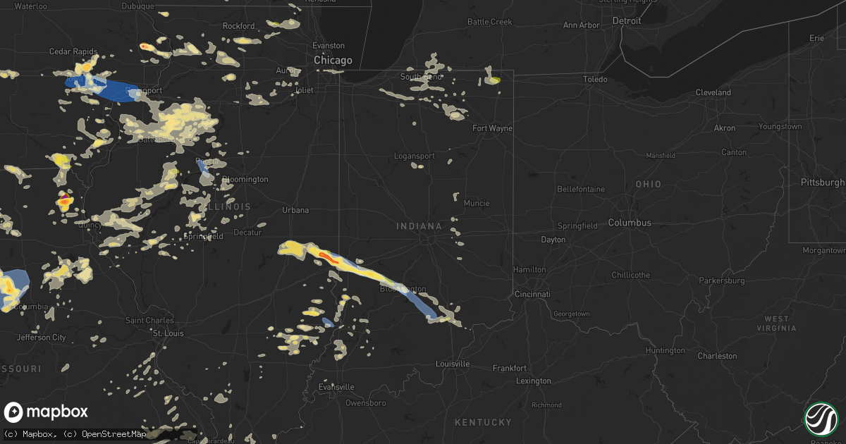
Hail Map in Indiana on June 25, 2024
Get this storm
June 25 map
$229
one time, instant access
Download today. No call, no setup
Keep the $229
Bought the map and want the full workflow? Apply the entire $229 to a subscription within 7 days. None of it is wasted.
Every map, not just this one
This buys you this map. Subscription and you get every map we run, in the markets you choose from a few cities to whole states to nationwide. Plus real-time alerts the moment a storm fires.
Contact data
Name, contact info, occupancy, even credit band for addresses in the footprint. You go from where it hit to who to call.
Become the source they trust
Unlimited branding weather history reports on demand. You already have the documented answer ready for the property owner, and you are the one who showed up with it.
Property data and RoofTrace estimates
Pull up any address you have got, its value and the exact code rules for that jurisdiction, straight from One Click Code. Then RoofTrace estimates the squares, pitch, and roof value, priced the way you price.
Storm reports in Indiana
Indiana
| Date | Description |
|---|---|
| 06/25/20244:20 PM CDT | Large tree down on main street between monroe and jefferson. |
| 06/25/20243:33 PM CDT | Delayed report. Numerous trees downed. |
| 06/25/20243:30 PM CDT | Delayed report. Time estimated by radar. Multiple large trees and power lines down in southeast part of the county. Roads are blocked. |
| 06/25/20243:12 PM CDT | Peak wind speed is preliminary. |
| 06/25/20243:06 PM CDT | Three-inch diameter branches were blown down by thunderstorm winds. |
| 06/25/20243:06 PM CDT | A tree and tree limbs were blown down by thunderstorm winds. Details are unavailable due to amateur radio conditions. |
| 06/25/20243:05 PM CDT | A utility line was blown down by thunderstorm winds near 6th street and sycamore street. |
| 06/25/20243:05 PM CDT | A tree and utility lines were downed by thunderstorm winds at state rd 550 near vine street. |
| 06/25/20243:05 PM CDT | A tree was blown down by thunderstorm winds at 3rd street and alexander. |
| 06/25/20243:05 PM CDT | Eight-inch tree branches were blown down by thunderstorm winds near the intersection of south olcott boulevard and east moores pike. Pea-size hail accompanied the winds |
| 06/25/20243:05 PM CDT | A 2.5-inch diameter healthy tree split due to thunderstorm winds. Time approximated. |
| 06/25/20243:05 PM CDT | Eight-inch tre mo 3907 9157 5 inch tree limbs down. No power in town. |
| 06/25/20243:02 PM CDT | Tree branches of unknown size were blown down by thunderstorm winds. |
| 06/25/20243:00 PM CDT | A roof was blown off a garage near the intersection of robinson road and kiewig drive by thunderstorm winds. |
| 06/25/20242:55 PM CDT | A local report indicates 60 MPH wind near 1 SE Bloomington |
| 06/25/20242:52 PM CDT | Report from mping...quarter size hail. |
| 06/25/20242:27 PM CDT | Delayed report. Trees down west of spencer. Time estimated by radar. |
| 06/25/20242:07 PM CDT | Delayed report. Strong sustained wind gusts knocked over corn crop and snapped large old growth trees over plus several large limbs of others landing on power lines wit |
| 06/25/20242:04 PM CDT | Preliminary max gust. |
| 06/25/20242:04 PM CDT | Trees and powerlines down east of lewis township. |
| 06/25/20242:02 PM CDT | Thunderstorm winds have blown off one or more of the following...roof shingles... Branches... Awnings... Fences... And carports onto cars. |
| 06/25/20242:00 PM CDT | A small tree was uprooted and another tree split by thunderstorm winds. Time is approximate. |
| 06/25/20242:00 PM CDT | A large branch was sheared off a a large tree and a large sign in a parking lot near the road edge was blown down as a result of thunderstorm winds. Time is approximate |
| 06/25/20242:00 PM CDT | Thunderstorm winds blew down a tree that is blocking cherrywood street. |
| 06/25/20242:00 PM CDT | A tree was blown down by thunderstorm winds and is blocking raymond drive. Time is approximate. |
| 06/25/20242:00 PM CDT | Several full grown trees and a flag pole have been blown down by thunderstorm winds. |
| 06/25/20241:50 PM CDT | Small branches off trees and pea size hail. |
| 06/25/202411:05 AM CDT | Em reported there were trees down across the county from earlier storms. |
| 06/25/202410:37 AM CDT | Alexandria is closed both directions for a tree across the road on top of a car with occupants inside. Time is roughly approximated. |
| 06/25/20249:26 AM CDT | Large tree downed and several large tree limbs down. Time estimated from radar. |
| 06/25/20249:05 AM CDT | Multiple trees down. Time estimated by radar. |
| 06/25/20249:02 AM CDT | Delayed report. Large tree uprooted. Time estie branches were blown down by thunderstorm winds near the intersection of south olcott boulevard and east moores pike. Pea-size |
| 06/25/20249:02 AM CDT | Delayed report. Large tree uprooted. Time estimated from radar. |
| 06/25/20248:58 AM CDT | Tree down on a house and trees downed on bourbon st. South of the rail road tracks as well. Em reports bourbon is out of power. |
| 06/25/20248:39 AM CDT | Trees down on powerlines... Wb 106 near bremen. Time estimated by radar. |
| 06/25/20248:32 AM CDT | Delayed report. Near new road and us route 31. |
| 06/25/20248:29 AM CDT | Large tree blocking 3/4 of the roadway via social media. Time estimated by radar. |
| 06/25/20248:29 AM CDT | Delayed report of a few large tree limbs down on county road 28 between county road 1 and 3. |
| 06/25/20248:27 AM CDT | Trees and power lines down in green township... Near roosevelt and mulberry road. |
| 06/25/20248:24 AM CDT | Tree downed blocking both lanes near myrtle and kern road. Time estimated from radar. |
| 06/25/20248:22 AM CDT | Trained spotter reported quarter inch hail at i-69 and us-20. |
| 06/25/20248:20 AM CDT | Trees down on pear road. Time estimated from radar. |
| 06/25/20248:20 AM CDT | Large tree downed near erie and roger st. Time estimated from radar. |
| 06/25/20248:15 AM CDT | Tree downed blocking the road on redwood road. Time estimated from radar. |
| 06/25/20248:15 AM CDT | Few trees and large limbs down along with power lines down in lagrange county. Approx 350-400 customers without power. Time estimated by radar. |
All States Impacted by Hail Map on June 25, 2024
Cities Impacted by Hail Map on June 25, 2024
- Whitehall, MI
- Holton, MI
- Muskegon, MI
- Twin Lake, MI
- Montague, MI
- Newaygo, MI
- Fremont, MI
- Grant, MI
- Conklin, MI
- Fenwick, MI
- Rockford, MI
- Fruitport, MI
- Ravenna, MI
- Sparta, MI
- Kent City, MI
- Greenville, MI
- Casnovia, MI
- Sand Lake, MI
- Bailey, MI
- Cedar Springs, MI
- Gowen, MI
- Lowell, MI
- Wayland, MI
- Saugatuck, MI
- Nunica, MI
- Marne, MI
- Hopkins, MI
- Zeeland, MI
- Orleans, MI
- Fennville, MI
- Allendale, MI
- Grandville, MI
- Jenison, MI
- West Olive, MI
- Wyoming, MI
- Caledonia, MI
- Spring Lake, MI
- Dorr, MI
- Byron Center, MI
- Holland, MI
- Allegan, MI
- Belmont, MI
- Grand Rapids, MI
- Comstock Park, MI
- Grand Haven, MI
- Coopersville, MI
- Macatawa, MI
- Belding, MI
- Hudsonville, MI
- Hamilton, MI
- Ada, MI
- Saranac, MI
- Freeport, MI
- Alto, MI
- Ionia, MI
- Lake Odessa, MI
- Middleville, MI
- Portland, MI
- Clarksville, MI
- Hastings, MI
- Shelbyville, MI
- Thomson, IL
- Mount Carroll, IL
- West Branch, IA
- Tipton, IA
- Monroe Center, IL
- Davis Junction, IL
- Kewanee, IL
- Annawan, IL
- Sheffield, IL
- Earlville, IL
- Sterling, IL
- Atalissa, IA
- Chadwick, IL
- Lanark, IL
- Cambridge, IL
- Atkinson, IL
- Geneseo, IL
- Oregon, IL
- Leaf River, IL
- Stillman Valley, IL
- Lindenwood, IL
- Kirkland, IL
- Esmond, IL
- Athens, MI
- Union City, MI
- East Leroy, MI
- Marcellus, MI
- Decatur, MI
- Schoolcraft, MI
- Lawton, MI
- Riverside, IA
- North Aurora, IL
- Aurora, IL
- Watervliet, MI
- Kalona, IA
- Wellman, IA
- Bangor, MI
- Covert, MI
- Milledgeville, IL
- Mchenry, IL
- Polo, IL
- Mount Morris, IL
- Forreston, IL
- Buda, IL
- Kingston, IL
- Chicago, IL
- Lone Tree, IA
- Woodstock, IL
- Galva, IL
- Jackson, MI
- West Liberty, IA
- Grass Lake, MI
- Bennett, IA
- Union, IL
- Marengo, IL
- Huntley, IL
- Wonder Lake, IL
- Dixon, IL
- Neponset, IL
- Sherwood, MI
- Mineral, IL
- Wyanet, IL
- Murray, IA
- Sycamore, IL
- Clare, IL
- Byron, IL
- Plainfield, IL
- Naperville, IL
- Oswego, IL
- Yorkville, IL
- Coloma, MI
- Hartford, MI
- Leland, IL
- Sherrard, IL
- Bishop Hill, IL
- Eau Claire, MI
- Sodus, MI
- Genoa, IL
- Manchester, MI
- Crystal Lake, IL
- Chelsea, MI
- Clarklake, MI
- Brooklyn, MI
- Bradford, IL
- Altona, IL
- Tiskilwa, IL
- Toulon, IL
- Woodhull, IL
- Dowagiac, MI
- Berrien Center, MI
- Franklin Grove, IL
- La Grange, IL
- Amboy, IL
- La Moille, IL
- Sublette, IL
- West Brooklyn, IL
- Morrison, IL
- Cassopolis, MI
- Compton, IL
- Spring Grove, IL
- Iowa City, IA
- Bronson, MI
- Holcomb, IL
- Benton Harbor, MI
- Addison, MI
- Cement City, MI
- Burbank, IL
- Justice, IL
- Willow Springs, IL
- Vandalia, MI
- Rochelle, IL
- Niles, MI
- Berrien Springs, MI
- Island Lake, IL
- Antioch, IL
- Alexis, IL
- Lynn Center, IL
- Newark, IL
- Salem, WI
- Trevor, WI
- Wauconda, IL
- Round Lake, IL
- Cary, IL
- Grayslake, IL
- Barrington, IL
- Ashton, IL
- Thayer, IA
- Steward, IL
- Bolingbrook, IL
- Twin Lakes, WI
- Richmond, IL
- Orland, IN
- Howe, IN
- Jones, MI
- White Pigeon, MI
- Oneida, IL
- New Boston, IL
- Joy, IL
- Seaton, IL
- Edwardsburg, MI
- Evergreen Park, IL
- Keota, IA
- Aledo, IL
- Little York, IL
- Shorewood, IL
- Minooka, IL
- Union, MI
- Lagrange, IN
- La Fayette, IL
- Mendota, IL
- Bristol, IN
- Joliet, IL
- Galesburg, IL
- Rio, IL
- Lake Villa, IL
- West Chester, IA
- Washington, IA
- Angola, IN
- Buchanan, MI
- Henderson, IL
- Wataga, IL
- Orion, IL
- Walkerton, IN
- Gerlaw, IL
- Ottawa, IL
- Wolcottville, IN
- La Salle, IL
- Peru, IL
- Utica, IL
- Serena, IL
- Hudson, IN
- South Bend, IN
- North Liberty, IN
- Wauseon, OH
- Delta, OH
- Wyoming, IL
- Elkhart, IN
- Osceola, IN
- Granger, IN
- Mishawaka, IN
- Victoria, IL
- Goshen, IN
- Seneca, IL
- Wedron, IL
- Wakarusa, IN
- Marseilles, IL
- Speer, IL
- Middlebury, IN
- Alpha, IL
- Pleasant Lake, IN
- Lakeville, IN
- Bremen, IN
- Ligonier, IN
- Hamlet, IN
- Union Mills, IN
- Westville, IN
- Kingsford Heights, IN
- La Porte, IN
- Davis City, IA
- Williamsfield, IL
- Monmouth, IL
- North Henderson, IL
- Nappanee, IN
- New Paris, IN
- Leon, IA
- Lineville, IA
- Princeville, IL
- Oquawka, IL
- Knoxville, IL
- Syracuse, IN
- Millersburg, IN
- Grovertown, IN
- Plymouth, IN
- Laura, IL
- Leesburg, IN
- Milford, IN
- Cromwell, IN
- Etna Green, IN
- Warsaw, IN
- Dahinda, IL
- East Galesburg, IL
- Brimfield, IL
- Rochester, IN
- Culver, IN
- Pierceton, IN
- Winona Lake, IN
- Larwill, IN
- Columbia City, IN
- North Webster, IN
- Elmwood, IL
- Cainsville, MO
- El Paso, IL
- Roanoke, IL
- Benson, IL
- Mercer, MO
- Gilson, IL
- La Fontaine, IN
- Wabash, IN
- Pekin, IL
- Keosauqua, IA
- Deer Creek, IL
- Eureka, IL
- Washington, IL
- Morton, IL
- Walton, IN
- Galveston, IN
- Logansport, IN
- East Peoria, IL
- Metamora, IL
- South Pekin, IL
- Tremont, IL
- Green Valley, IL
- Peoria, IL
- Groveland, IL
- Creve Coeur, IL
- Peoria Heights, IL
- Wapakoneta, OH
- Bonaparte, IA
- Fairview, IL
- Canton, IL
- Ellisville, IL
- Smithfield, IL
- Anna, OH
- Jackson Center, OH
- Maplewood, OH
- Sidney, OH
- Camden, IN
- Delavan, IL
- Port Jefferson, OH
- Botkins, OH
- Quincy, OH
- De Graff, OH
- Topeka, IL
- Havana, IL
- Stanford, IL
- Minier, IL
- Cuba, IL
- Armington, IL
- Milton, IA
- Douds, IA
- Manito, IL
- Forest City, IL
- Bellefontaine, OH
- Lewistown, OH
- Huntsville, OH
- Table Grove, IL
- Adair, IL
- Summitville, IN
- Alexandria, IN
- Kahoka, MO
- Farmington, IA
- Mount Sterling, IA
- West Liberty, OH
- Hopedale, IL
- Lewistown, IL
- Vermont, IL
- Ipava, IL
- McLean, IL
- Easton, IL
- Mason City, IL
- Zanesfield, OH
- Urbana, OH
- San Jose, IL
- New Holland, IL
- Bryant, IL
- Pendleton, IN
- Emden, IL
- Atlanta, IL
- Rushville, IL
- Industry, IL
- Liverpool, IL
- Fortville, IN
- Greenfield, IN
- Macomb, IL
- Hartsburg, IL
- Plymouth, IL
- Littleton, IL
- Augusta, IL
- Kenney, IL
- Lincoln, IL
- Waterloo, IN
- Ashley, IN
- London, OH
- Maroa, IL
- Chestnut, IL
- Charlottesville, IN
- Camden, IL
- Huntsville, IL
- Mount Pulaski, IL
- Carthage, IN
- Morristown, IN
- Arlington, IN
- Downing, MO
- Argenta, IL
- Latham, IL
- Arcola, IL
- Cerro Gordo, IL
- Milmine, IL
- La Prairie, IL
- Arthur, IL
- Tuscola, IL
- Petersburg, IL
- Greenview, IL
- Golden, IL
- Humboldt, IL
- Shelbyville, IN
- Waldron, IN
- Manilla, IN
- Athens, IL
- Clinton, IL
- Charleston, IL
- Brocton, IL
- Sullivan, IL
- Hindsboro, IL
- Mattoon, IL
- Oakland, IL
- Oreana, IL
- Monticello, IL
- Bement, IL
- Cisco, IL
- Timewell, IL
- Tallula, IL
- Beason, IL
- Oakford, IL
- Newman, IL
- Glasford, IL
- Astoria, IL
- Browning, IL
- Mount Sterling, IL
- Saint David, IL
- Kansas, IL
- Paris, IL
- Chillicothe, OH
- Frederick, IL
- Ashmore, IL
- Redmon, IL
- Ashland, IL
- Martinsville, IL
- Dennison, IL
- West Terre Haute, IN
- Quincy, IL
- Marshall, IL
- Meredosia, IL
- Jacksonville, IL
- Maywood, MO
- Durham, MO
- Cantrall, IL
- Springfield, IL
- Chapin, IL
- La Grange, MO
- Ewing, MO
- Mendon, IL
- Terre Haute, IN
- Winchester, IL
- Bluffs, IL
- Clayton, IL
- Camp Point, IL
- Fowler, IL
- Greenup, IL
- Sherman, IL
- Concord, IL
- Arenzville, IL
- Brazil, IN
- Riley, IN
- Taylor, MO
- Staunton, IN
- Farmersburg, IN
- Cory, IN
- Pleasant Plains, IL
- Cordesville, SC
- Annapolis, IL
- Willow Hill, IL
- Oblong, IL
- Buffalo, IL
- Paloma, IL
- Coatsburg, IL
- Centerpoint, IN
- Clay City, IN
- Bowling Green, IN
- Coal City, IN
- West Liberty, IL
- North Vernon, IN
- Dundas, IL
- Seymour, IN
- Versailles, IL
- Stoy, IL
- Robinson, IL
- Sullivan, IN
- Liberty, IL
- Alexander, IL
- New Berlin, IL
- Shelburn, IN
- Freedom, IN
- Sumner, IL
- Patricksburg, IN
- Spencer, IN
- Poland, IN
- Carlisle, IN
- Merom, IN
- Claremont, IL
- Flat Rock, IL
- Olney, IL
- Xenia, IL
- Dugger, IN
- Linton, IN
- Noble, IL
- Dawson, IL
- Riverton, IL
- Commiskey, IN
- Barry, IL
- Pittsfield, IL
- Brownstown, IN
- Crothersville, IN
- Bloomington, IN
- Kinderhook, IL
- Oaktown, IN
- Lawrenceville, IL
- Palestine, IL
- New Canton, IL
- Flora, IL
- Rinard, IL
- Hull, IL
- Rochester, IL
- Bridgeport, IL
- Baylis, IL
- New London, MO
- Bowman, SC
- Plainville, IL
- Clay City, IL
- Cisne, IL
- Green Cove Springs, FL
- West Union, IL
- Mount Erie, IL
- New Salem, IL
- Griggsville, IL
- Chambersburg, IL
- Calhoun, IL
- Elnora, IN
- West Salem, IL
- Washington, IN
- Ellettsville, IN
- Solsberry, IN
- Montgomery, IN
- Plainville, IN
- Seligman, AZ
- Parkersburg, IL
- Vincennes, IN
- Monroe City, IN
- Wheatland, IN
- Nashville, IN
- Saint Francisville, IL
- Murrayville, IL
- Mount Carmel, IL
- Rockport, IL
- Bicknell, IN
- Edwardsport, IN
- Vermilion, IL
- Gosport, IN
- Norman, IN
- Heltonville, IN
- Medora, IN
- Freetown, IN
- Vallonia, IN
- Pleasant Hill, IL
- Columbus, IN
- Ava, MO
- Squires, MO
- Geff, IL
- O'Brien, FL
- Sims, IL
- Summerton, SC
- Hazleton, IN
- Decker, IN
- Zolfo Springs, FL
- Vale, SD
- Newell, SD
- Waverly, IL
- Young, AZ
- Campbellsburg, IN
- Franklin, IL
- Golden Gate, IL
- Fairfield, IL
- Nisland, SD
- Francisco, IN
- Patoka, IN
- Payson, AZ
- Loami, IL
- Sturgis, SD
- Chatham, IL
- Hackberry, AZ
- Princeton, IN
- Jasper, IN
- Velpen, IN
- Huntingburg, IN
- Johnsonville, IL
- Albion, IL
- Palmyra, IL
- Paris Crossing, IN
- Austin, IN
- Bluford, IL
- New Carlisle, IN
- Galien, MI
- Enning, SD
- Union Center, SD
- Miles, IA
- Sabula, IA
- Louisiana, MO
- Ellery, IL
- Newton, IA
- McAlpin, FL
- Lexington, IN
- Scottsburg, IN
- Deputy, IN
- Stoutsville, MO
- Live Oak, FL
- Center, MO
- New Underwood, SD
- Vandalia, MO
- Frankford, MO
- Show Low, AZ
- Slater, MO
- Armstrong, MO
- Glasgow, MO
- Salisbury, MO
- Howes, SD
- Tallahassee, FL
- White Owl, SD
- Preston, IA
- Curryville, MO
- Perry, MO
- Fayette, MO
- Wasta, SD
- Santa Fe, MO
- Ridgeville, SC
- Gilliam, MO
- Walterboro, SC
- Amite, LA
- Greensburg, LA
- Higbee, MO
- Omaha, NE
- Council Bluffs, IA
- Shannon, IL
- Grinnell, IA
- Wall, SD
- Colfax, IA
- Summerville, SC
- Madison, MO
- Kellogg, IA
- Clinton, IA
- Fulton, IL
- Louisville, KY
- Sedona, AZ
- Saint Louis, MO
- Owanka, SD
- Box Elder, SD
- Bellevue, NE
- Garden Prairie, IL
- Harvard, IL
- Holliday, MO
- Paris, MO
- Monroe, IA
- Runnells, IA
- Mitchellville, IA
- Prairie City, IA
- Rocheport, MO
- Malcom, IA
- Marland, OK
- Gregory, SD
- Mexico, MO
- Harrisburg, MO
- Clark, MO
- Sturgeon, MO
- Ponca City, OK
- Coulterville, IL
- Mechanicsville, IA
- Winfield, KS
- Centralia, MO
- Laddonia, MO
- Thompson, MO
- Quinn, SD
- Philip, SD
- Ely, IA
- Bassett, NE
- Arkansas City, KS
- New Franklin, MO
- Kaw City, OK
- Belle, MO
- Offutt Afb, NE
- Fernley, NV
- Silver Springs, NV
- Farber, MO
- Plainview, NE
- Neligh, NE
- Lisbon, IA
- Boonville, MO
- Meadow Grove, NE
- Brooklyn, IA
- Pierce, NE
- Ewing, NE
- Inman, NE
- Stuart, NE
- Atkinson, NE
- Amelia, NE
- La Vista, NE
- Papillion, NE
- Pacific Junction, IA
- Franklin, MO
- Potosi, MO
- Belvidere, IL
- Wellington, KS
- Bryant, IA
- Glenwood, IA
- Rapid City, SD
- Tilden, NE
- Battle Creek, NE
- Delmar, IA
- Maquoketa, IA
- Newkirk, OK
- Burwell, NE
- Belle Plaine, KS
- Rimrock, AZ
- Auxvasse, MO
- Imperial, MO
- Barnhart, MO
- Mulvane, KS
- Udall, KS
- Hermosa, SD
- Caputa, SD
- Clearwater, NE
- Hartford, IA
- Swan, IA
- Carlisle, IA
- Pleasantville, IA
- Ackworth, IA
- Miami, TX
- Clarence, IA
- Charlotte, IA
- Hillsboro, MO
- Mount Vernon, IL
- Ralston, OK
- Shidler, OK
- Burbank, OK
- New Haven, MO
- Stockport, IA
- Hampshire, IL
- Warrenton, MO
- Goose Lake, IA
- Scenic, SD
- Kyle, SD
- Columbia, IL
- Kingdom City, MO
- Fulton, MO
- Palmyra, MO
- Valentine, NE
- Crescent, IA
- Seneca, NE
- Kadoka, SD
- Interior, SD
- Wanblee, SD
- Lewistown, MO
- Mullen, NE
- Pleasant Hill, IA
- Des Moines, IA
- Corydon, KY
- Henderson, KY
- Plattsmouth, NE
- Panhandle, TX
- Amarillo, TX
- Portales, NM
- Carter Lake, IA
- Norfolk, NE
- Norwalk, IA
- Altoona, IA
- Red Rock, OK
- Pawnee, OK
- Berger, MO
- Hermann, MO
- Cumming, IA
- Mclean, NE
- Osmond, NE
- De Soto, MO
- Orange City, FL
- Stanwood, IA
- Indianola, IA
- Oxford, KS
- Leslie, MO
- Blackwell, MO
- Fletcher, MO
- Solon, IA
- Allen, SD
- Mount Vernon, IA
- Danville, IA
- Prole, IA
- Madison, NE
- North Liberty, IA
- Festus, MO
- Owensville, MO
- Marathon, TX
- Randolph, NE
- Coleridge, NE
- La Belle, MO
- Knox City, MO
- Honey Creek, IA
- Underwood, IA
- Coralville, IA
- Debary, FL
- Neola, IA
- Martin, SD
- Magnet, NE
- Hartington, NE
- New London, IA
- Chariton, IA
- Lacona, IA
- Knoxville, IA
- De Witt, IA
- Williamstown, MO
- Monticello, MO
- Perry, OK
- Pawhuska, OK
- Russell, IA
- New Windsor, IL
- Tiffin, IA
- Lucas, IA
- Oxford, IA
- Pevely, MO
- Hills, IA
- Van Meter, IA
- Belle Rive, IL
- Viola, IL
- Bloomfield, NE
- Billings, OK
- Minden, IA
- Persia, IA
- Shelby, IA
- Avoca, IA
- Melcher Dallas, IA
- Columbia, IA
- Wyaconda, MO
- Morrison, OK
- Canton, MO
- Springfield, NE
- Owensboro, KY
- West Burlington, IA
- Yarmouth, IA
- Burlington, IA
- Sperry, IA
- Johnstown, NE
- Nichols, IA
- Sebree, KY
- Robards, KY
- Luray, MO
- Genoa City, WI
- San Manuel, AZ
- French Village, MO
- Tuthill, SD
- Merriman, NE
- Cody, NE
- Claude, TX
- Canyon, TX
- Stanton, NE
- Clarkson, NE
- Creston, NE
- Leigh, NE
- Long Valley, SD
- Causey, NM
- Calhoun, KY
- Saint Patrick, MO
- Blackwell, OK
- Slaughters, KY
- Dixon, KY
- Sparland, IL
- Farmington, MO
- Sainte Genevieve, MO
- South Amana, IA
- Homestead, IA
- Marengo, IA
- Sparks, NV
- Mineral Point, MO
- Putnam, IL
- Henry, IL
- Madisonville, KY
- Nebo, KY
- Van Buren, MO
- Ellington, MO
- Irondale, MO
- Lindsay, NE
- Saint Edward, NE
- Humphrey, NE
- Monroe, NE
- Wausa, NE
- Creighton, NE
- Norris, SD
- Page, NE
- Orchard, NE
- Orlando, OK
- Stillwater, OK
- Laurel, NE
- Newcastle, NE
- Ponca, NE
- Muscatine, IA
- Wilton, IA
- Durant, IA
- Moscow, IA
- Illinois City, IL
- Stockton, IA
- Walcott, IA
- Davenport, IA
- Blue Grass, IA
- Reynolds, IL
- Andalusia, IL
- Buffalo, IA
- Montpelier, IA
- Taylor Ridge, IL
- Milan, IL
- Rock Island, IL
- Missouri Valley, IA
- Bettendorf, IA
- Logan, IA
- Janesville, WI
- Brodhead, WI
- Sedan, KS
- Bonne Terre, MO
- Park Hills, MO
- Winner, SD
- Corydon, IA
- Manitou, KY
- Pampa, TX
- Vienna, MO
- Cedar Vale, KS
- Tonkawa, OK
- Keithsburg, IL
- Derby, IA
- Melrose, IA
- Bloomsdale, MO
- Harlan, IA
- Schuyler, NE
- Evansville, WI
- Crofton, NE
- Whitman, NE
- Milton, WI
- Avalon, WI
- Whitewater, WI
- Darien, WI
- Winnetoon, NE
- Platte Center, NE
- Winfield, IA
- Olds, IA
- Crawfordsville, IA
- Mount Pleasant, IA
- Osco, IL
- Wood, SD
- Ladora, IA
- Lovington, NM
- Parmelee, SD
- White River, SD
- Adel, IA
- Earlham, IA
- Winterset, IA
- Montezuma, IA
- West Des Moines, IA
- Saint Charles, IA
- Bevington, IA
- Truro, IA
- Williamsburg, IA
- Rogers, NM
- Cadet, MO
- New Virginia, IA
- Kirkwood, IL
- Hanson, KY
- Edelstein, IL
- Chillicothe, IL
- Coal Valley, IL
- Footville, WI
- Cantril, IA
- Nashville, IL
- Patterson, IA
- Woodbine, IA
- Portsmouth, IA
- Kirkman, IA
- Irwin, IA
- Grand River, IA
- Van Wert, IA
- Mulhall, OK
- Perkins, OK
- Coyle, OK
- Elk City, KS
- Modale, IA
- Saint Francis, SD
- Orfordville, WI
- Lowpoint, IL
- Peru, IA
- Lorimor, IA
- Fort Calhoun, NE
- Blair, NE
- Galena, IL
- Scales Mound, IL
- Elizabeth, IL
- Panama, IA
- Ophiem, IL
- Ashley, IL
- Du Bois, IL
- Yates City, IL
- Vichy, MO
- Menlo, IA
- Greenfield, IA
- Kimballton, IA
- Audubon, IA
- Manning, IA
- Fordyce, NE
- Hoskins, NE
- Verdigre, NE
- Havana, KS
- Independence, KS
- Covington, OK
- Cameron, IL
- Magnolia, IA
- Farmington, IL
- Hancock, IA
- Washburn, IL
- Maquon, IL
- Royal, NE
- Richwoods, MO
- Swisher, IA
- Mediapolis, IA
- Piedmont, MO
- Mill Spring, MO
- Middletown, IA
- Patterson, MO
- Garber, OK
- Mission, SD
- Mount Union, IA
- Tryon, OK
- Meridian, OK
- Wellston, OK
- Guthrie, OK
- Happy, TX
- Tulia, TX
- Pond Creek, OK
- Arbela, MO
- Fleming Island, FL
- Jacksonville, FL
- Westphalia, IA
- Earling, IA
- Sharon, OK
- Kilgore, NE
- McClelland, IA
- De Soto, IA
- Marshall, OK
- Douglas, OK
- Lucien, OK
- Saint Mary, MO
- Stuart, IA
- Guthrie Center, IA
- Panora, IA
- Winside, NE
- Wynot, NE
- Saint Helena, NE
- Luther, OK
- Carney, OK
- Dunlap, IA
- Hunter, OK
- Gordon, NE
- London Mills, IL
- Conesville, IA
- Longton, KS
- Hennessey, OK
- Denison, IA
- Ainsworth, IA
- Columbus Junction, IA
- Bourbon, MO
- Mapleton, IL
- Hanna City, IL
- Hamlin, IA
- Coon Rapids, IA
- Adair, IA
- Bison, OK
- Crescent, OK
- Kingfisher, OK
- Cashion, OK
- Tryon, NE
- Little Sioux, IA
- Onawa, IA
- Pisgah, IA
- Soldier, IA
- Moorhead, IA
- Cottageville, SC
- Salem, IA
- Manilla, IA
- Afton, IA
- Wayne, NE
- Pilger, NE
- Pinckneyville, IL
- Dixon, NE
- Letts, IA
- Osceola, IA
- Mondamin, IA
- Tekamah, NE
- Bennington, NE
- Dow City, IA
- Ute, IA
- Rogers, NE
- Dodge, NE
- Howells, NE
- Valley, NE
- Elkhorn, NE
- Waterloo, NE
- Linden, IA
- Redfield, IA
- Moulton, IA
- Coatsville, MO
- Bloomfield, IA
- Dexter, IA
- Ellston, IA
- Nash, OK
- West Point, IA
- Wooldridge, MO
- Jamestown, MO
- Cherryvale, KS
- Columbia, MO
- Arlington, NE
- Kennard, NE
- Arnett, OK
- Cedar Bluffs, NE
- Morse Bluff, NE
- North Bend, NE
- Lancaster, MO
- Charter Oak, IA
- Piedmont, OK
- Edmond, OK
- Arcadia, OK
- Oakland, IA
- Treynor, IA
- Macedonia, IA
- Silver City, IA
- Carson, IA
- Sutherland, NE
- Vail, IA
- Westside, IA
- Casey, IA
- Enid, OK
- Niobrara, NE
- Shannon City, IA
- Thedford, NE
- Creston, IA
- Wapello, IA
- Fontanelle, IA
- Queen City, MO
- Kiron, IA
- Deloit, IA
- Diagonal, IA
- Kilbourne, IL
- Weldon, IA
- Decatur, IA
- Gerald, MO
- Lenox, IA
- Dimmitt, TX
- Springfield, SD
- Newport, NE
- Orient, IA
- Hereford, TX
- Minburn, IA
- Dallas Center, IA
- Waukee, IA
- Oklahoma City, OK
- Bethany, OK
- Yukon, OK
- Choctaw, OK
- Jones, OK
- Spencer, OK
- Albion, NE
- Newman Grove, NE
- Emerson, IA
- Red Oak, IA
- Griswold, IA
- Elliott, IA
- Henderson, IA
- Lewis, IA
- Cumberland, IA
- Atlantic, IA
- Villisca, IA
- Grant, IA
- New Bloomfield, MO
- Prescott, IA
- Macksburg, IA
- Elgin, NE
- Nazareth, TX
- Corning, IA
- Donnellson, IA
- Bisbee, AZ
- Hillsboro, IA
- Martensdale, IA
- Washington, NE
- Hartsburg, MO
- Purdum, NE
- Williamson, IA
- Milo, IA
- Montgomery City, MO
- Williamsburg, MO
- Norman, OK
- Columbus, NE
- Center, NE
- Mount Ayr, IA
- Kellerton, IA
- Murphysboro, IL
- Ava, IL
- Ellsinore, MO
- Morning Sun, IA
- Tingley, IA
- Newark, MO
- Genoa, NE
- Carbon, IA
- Massena, IA
- Nodaway, IA
- Bridgewater, IA
- Urbandale, IA
- Clive, IA
- Grimes, IA
- Harrah, OK
- Mcloud, OK
- Newalla, OK
- Hart, TX
- Clearfield, IA
- Jefferson City, MO
- Lamoni, IA
- Alexandria, MO
- Ames, NE
- Ashland, MO
- Fredericktown, MO
- Fremont, NE
- Gravity, IA
- Yutan, NE
- Colon, NE
- Bethel, MO
- Benton, IA
- Blockton, IA
- Des Arc, MO
- Annapolis, MO
- New Market, IA
- Bedford, IA
- Sharpsburg, IA
- Boys Town, NE
- Shawnee, OK
- Tecumseh, OK
- Noble, OK
- Wanette, OK
- Macomb, OK
- Lexington, OK
- Clarinda, IA
- Avon, SD
- Millerton, IA
- Shambaugh, IA
- Lovilia, IA
- Plano, IA
- Promise City, IA
- Marquand, MO
- Schleswig, IA
- Evansville, IN
- Nebraska City, NE
- Oneill, NE
- Chambers, NE
- Talmage, NE
- Nickerson, NE
- Cedar Rapids, NE
- Redding, IA
- Brock, NE
- Herman, NE
- Sheridan, MO
- Hopkins, MO
- Salem, KY
- Marion, KY
- Julian, NE
- Peru, NE
- Humeston, IA
- Fullerton, NE
- Hagarville, AR
- Lamar, AR
- Hershey, NE
- Hatfield, MO
- Patton, MO
- Garden Grove, IA
- Perryville, MO
- Belgrade, NE
- Malvern, IA
- Cape Girardeau, MO
- Chaffee, MO
- Ord, NE
- Elyria, NE
- Silver Creek, NE
- Osceola, NE
- Clarks, NE
- Wolbach, NE
- Auburn, NE
- Brownville, NE
- Stanberry, MO
- Primrose, NE
- Shelbina, MO
- Grant City, MO
- Fairfax, MO
- Rock Port, MO
- Denver, MO
- Worth, MO
- Pickering, MO
- Parnell, MO
- Maryville, MO
- Ravenwood, MO
- Barnard, MO
- Gentry, MO
- Conception Junction, MO
- Skidmore, MO
- Graham, MO
- Bolckow, MO
- Conception, MO
- Clyde, MO
- Guilford, MO
- Martinsville, MO
- Darlington, MO
- Rea, MO
- New Hampton, MO
- McFall, MO
- Rosendale, MO
- Albany, MO
- Bethany, MO
- King City, MO
- Eagleville, MO
- Ridgeway, MO
- Blythedale, MO
- Princeton, MO
- Savannah, MO
- Union Star, MO
- Dunbar, NE
- Milan, MO
- Pollock, MO
- Kremlin, OK
- Green City, MO
- Lorton, NE
- Randolph, IA
- Unionville, MO
- Farragut, IA
- Glenwood, MO
- Payson, IL
- Nemaha, NE
- Kirksville, MO
- Brashear, MO
- Amity, MO
- Maysville, MO
- Central City, NE
- Essex, IA
- Shenandoah, IA
- Greenville, MO
- Imogene, IA
- Avoca, NE
- Riverton, IA
- Sidney, IA
- Wadesville, IN
- Craig, MO
- Oakdale, NE
- Falls City, NE
- Shubert, NE
- Verdon, NE
- Stella, NE
- Stromsburg, NE
- Polk, NE
- Hordville, NE
- Ashland, NE
- Petersburg, NE
- Otoe, NE
- Saint Paul, NE
- Palmer, NE
- Archer, NE
- Chapman, NE
- Boelus, NE
- Saint Libory, NE
- Dannebrog, NE
- Cairo, NE
- Rockville, NE
- Marquette, NE
- Wood River, NE
- Gibbon, NE
- Grand Island, NE
- Shelton, NE
- Ravenna, NE
- Phillips, NE
- Alda, NE
- Kenesaw, NE
- Juniata, NE
- Aurora, NE
- Hastings, NE
- Doniphan, NE
- Trumbull, NE
- Giltner, NE
- Maitland, MO
- Oregon, MO
- White Cloud, KS
- Forest City, MO
- Mound City, MO
- Rulo, NE
- Coffey, MO
- Gilman City, MO
- Humphreys, MO
- Jamesport, MO
- Galt, MO
- Pattonsburg, MO
- Spickard, MO
- Jameson, MO
- Trenton, MO
- Harris, MO
- Laredo, MO
- Altamont, MO
- Helena, MO
- Gallatin, MO
- Browning, MO
- Easton, MO
- Clarksdale, MO
- Weatherby, MO
- Cameron, MO
- Saint Joseph, MO
- Winston, MO
- Osborn, MO
- Stewartsville, MO
- Cosby, MO
- Ewing, IL
- Macedonia, IL
- Breckenridge, MO
- Hamilton, MO
- Chula, MO
- Chillicothe, MO
- Lock Springs, MO
- Kidder, MO
- Wheeling, MO
- Garland, NE
- Malcolm, NE
- Pleasant Dale, NE
- Benedict, NE
- Grandin, MO
- Greenwood, NE
- Neodesha, KS
- Valles Mines, MO
- Syracuse, NE
- Palmyra, NE
- Unadilla, NE
- Taylor, NE
- Lincoln, NE
- Saronville, NE
- Bradshaw, NE
- Clay Center, NE
- Hampton, NE
- Sutton, NE
- Harvard, NE
- York, NE
- Inland, NE
- Henderson, NE
- Louisville, NE
- Almo, KY
- Benton, KY
- Hardin, KY
- Dexter, KY
- South Bend, NE
- Murray, NE
- Nehawka, NE
- Memphis, MO
- Gretna, NE
- Naylor, MO
- Success, AR
- Vergennes, IL
- Templeton, IA
- Saint Paul, IA
- Liberty, KS
- Waverly, NE
- Moline, IL
- Amazonia, MO
- Seward, NE
- Milford, NE
- Cordova, NE
- Beaver Crossing, NE
- Exeter, NE
- McCool Junction, NE
- Waco, NE
- Utica, NE
- Friend, NE
- Fairmont, NE
- Dorchester, NE
- Grafton, NE
- Geneva, NE
- Tobias, NE
- Milligan, NE
- Ohiowa, NE
- Linneus, MO
- Meadville, MO
- Mooresville, MO
- Utica, MO
- Plattsburg, MO
- Braymer, MO
- Dawn, MO
- Turney, MO
- Cowgill, MO
- Lawson, MO
- Ludlow, MO
- Kingston, MO
- Polo, MO
- Lathrop, MO
- Wagner, SD
- Whitewater, MO
- Marble Hill, MO
- Burfordville, MO
- Highland, KS
- Troy, KS
- Palmersville, TN
- Fulton, KY
- Sedalia, KY
- Dukedom, TN
- De Soto, IL
- Brunswick, NE
- Vermillion, SD
- Murray, KY
- Green Castle, MO
- Wathena, KS
- Sedgewickville, MO
- Cedar Creek, NE
- Sterling, NE
- Cook, NE
- Robinson, KS
- Doniphan, MO
- Superior, NE
- Daykin, NE
- Byron, NE
- Deshler, NE
- Jackson, MO
- Lost Nation, IA
- Oak Ridge, MO
- Glenallen, MO
- Millersville, MO
- Alexandria, NE
- Chamois, MO
- Rayville, MO
- Hardin, MO
- Carrollton, MO
- Tina, MO
- Bogard, MO
- Norborne, MO
- Richmond, MO
- Hale, MO
- Bosworth, MO
- Odell, NE
- Crete, NE
- Clatonia, NE
- Cortland, NE
- Beatrice, NE
- Swanton, NE
- Virginia, NE
- Filley, NE
- Blue Springs, NE
- Wymore, NE
- Wilber, NE
- Hallam, NE
- De Witt, NE
- Plymouth, NE
- Pickrell, NE
- Western, NE
- Steele City, NE
- Diller, NE
- Jansen, NE
- Fairbury, NE
- Bremen, KS
- Hollenberg, KS
- Barnes, KS
- Hanover, KS
- Marysville, KS
- Greenleaf, KS
- Washington, KS
- Endicott, NE
- Hubbell, NE
- Gilead, NE
- Reynolds, NE
- Hebron, NE
- Narka, KS
- Scandia, KS
- Republic, KS
- Munden, KS
- Norway, KS
- Courtland, KS
- Belleville, KS
- Strang, NE
- Ethel, MO
- Elmer, MO
- Buchanan, TN
- New Concord, KY
- Maynard, AR
- Poplar Bluff, MO
- Williamsville, MO
- Denton, KS
- Mendon, MO
- Tecumseh, NE
- Chester, NE
- Warm Springs, AR
- Atchison, KS
- Jamestown, KS
- Pocahontas, AR
- Mahaska, KS
- Tamms, IL
- Ullin, IL
- Dongola, IL
- Keytesville, MO
- Anna, IL
- Higginsville, MO
- Malta Bend, MO
- Alma, MO
- Marshall, MO
- Dover, MO
- De Witt, MO
- Corder, MO
- Lexington, MO
- Waverly, MO
- Blackburn, MO
- Miami, MO
- Morrowville, KS
- Lewiston, NE
- Home, KS
- Beattie, KS
- Oketo, KS
- Barneston, NE
- Summerfield, KS
- Burchard, NE
- Pawnee City, NE
- Liberty, NE
- Axtell, KS
- Cuba, KS
- Haddam, KS
- Agenda, KS
- Morganville, KS
- Aurora, KS
- Linn, KS
- Blue Rapids, KS
- Concordia, KS
- Clyde, KS
- Clifton, KS
- Frankfort, KS
- Waterville, KS
- Palmer, KS
- Rockwood, IL
- Lodi, MO
- Clubb, MO
- Silva, MO
- Imboden, AR
- S Coffeyville, OK
- Arcadia, MO
- Baileyville, KS
- Erie, KS
- Chanute, KS
- Humboldt, KS
- Neosho Falls, KS
- Colony, KS
- Neelyville, MO
- Dover, TN
- Bevier, MO
- Beech Grove, AR
- Lenapah, OK
- Du Quoin, IL
- Elkville, IL
- Yorktown, IA
- Callao, MO
- Macon, MO
- Peach Orchard, AR
- Delaplaine, AR
- Onaga, KS
- Leonardville, KS
- Olsburg, KS
- Havensville, KS
- Westmoreland, KS
- Clay Center, KS
- Centralia, KS
- Vermillion, KS
- Randolph, KS
- Green, KS
- Corning, KS
- Miltonvale, KS
- Triplett, MO
- Huntsville, MO
- Dalton, MO
- Moberly, MO
- Clifton Hill, MO
- Brunswick, MO
- Nelson, MO
- Henrietta, MO
- Blackwater, MO
- Camden, MO
- Mayview, MO
- Concordia, MO
- Sweet Springs, MO
- Napoleon, MO
- Sibley, MO
- Oak Grove, MO
- Odessa, MO
- Orrick, MO
- Arrow Rock, MO
- Wellington, MO
- Bates City, MO
- Lone Jack, MO
- Houstonia, MO
- La Monte, MO
- Kingsville, MO
- Holden, MO
- Centerview, MO
- Knob Noster, MO
- Warrensburg, MO
- Pilot Grove, MO
- Hughesville, MO
- Sedalia, MO
- Sabetha, KS
- Wetmore, KS
- Seneca, KS
- Goff, KS
- Hooper, NE
- Du Bois, NE
- Mead, NE
- Coffeyville, KS
- Bern, KS
- New Boston, MO
- Biggers, AR
- Wann, OK
- Clearmont, MO
- Braddyville, IA
- Riley, KS
- Manhattan, KS
- Saint George, KS
- Wamego, KS
- Wakefield, KS
- Holton, KS
- Saint Marys, KS
- Soldier, KS
- Circleville, KS
- Belvue, KS
- Delia, KS
- Emmett, KS
- Iola, KS
- Rothville, MO
- Steelville, MO
- Cypress, IL
- Grand Chain, IL
- Vienna, IL
- Belknap, IL
- Karnak, IL
- Ironton, MO
- Whiting, KS
- Netawaka, KS
- Powhattan, KS
- Mayetta, KS
- Denison, KS
- Silver Lake, KS
- Topeka, KS
- Rossville, KS
- Maple Hill, KS
- Alma, KS
- Hoyt, KS
- Paxico, KS
- McFarland, KS
- Milford, KS
- Longford, KS
- Ogden, KS
- Eskridge, KS
- Harveyville, KS
- Auburn, KS
- Carbondale, KS
- Osawatomie, KS
- Wakarusa, KS
- Rantoul, KS
- Berryton, KS
- Ottawa, KS
- Overbrook, KS
- Pomona, KS
- Burlingame, KS
- Peru, KS
- Niotaze, KS
- Golconda, IL
- Independence, MO
- Buckner, MO
- Scranton, KS
- Quenemo, KS
- Vassar, KS
- Lyndon, KS
- Osage City, KS
- Tecumseh, KS
- Lawrence, KS
- Wellsville, KS
- Baldwin City, KS
- Reading, KS
- Allen, KS
- Jonesboro, AR
- Hampton, KY
- Smithland, KY
- Grain Valley, MO
- Galesburg, KS
- Richmond, KS
- Princeton, KS
- Halsey, NE
- Hanover, IN
- Blue Springs, MO
- La Plata, MO
- Novinger, MO
- Minneapolis, KS
- Solomon, KS
- Bennington, KS
- Kirksey, KY
- Piqua, KS
- Oxly, MO
- Claremore, OK
- Stilwell, KS
- Spalding, NE
- Clinton, MO
- Copan, OK
- Harrisburg, AR
- Weiner, AR
- Bay, AR
- Chelsea, OK
- Arnold, NE
- Winigan, MO
- Mayfield, KY
- Weeping Water, NE
- Garnett, KS
- Parsons, KS
- Centerville, KS
- Corning, AR
- Cole Camp, MO
- Mora, MO
- Chilhowee, MO
- Kincaid, KS
- Lane, KS
- Fillmore, MO
- Caney, KS
- Tyro, KS
- New Cambria, MO
- Winslow, IN
- Stover, MO
- Ansley, NE
- Mason City, NE
- Zalma, MO
- Lowndes, MO
- Wappapello, MO
- Lebo, KS
- Melvern, KS
- Waverly, KS
- Greeley, KS
- Williamsburg, KS
- Westphalia, KS
- Welda, KS
- Paola, KS
- Parker, KS
- Blue Mound, KS
- Burlington, KS
- Le Roy, KS
- Laclede, MO
- Brookfield, MO
- Gipsy, MO
- Atlanta, MO
- State University, AR
- Paragould, AR
- Dennis, KS
- Mound Valley, KS
- Warsaw, MO
- Uniontown, KS
- Bronson, KS
- Stark, KS
- Delaware, OK
- Barnsdall, OK
- Bartlesville, OK
- Humboldt, TN
- Elfrida, AZ
- Ochelata, OK
- Walnut, KS
- Elwood, KS
- Humansville, MO
- Collins, MO
- Pollard, AR
- Pittsburg, MO
- Edna, KS
- Ramona, OK
- Bolivar, MO
- Flemington, MO
- Gainesville, MO
- Girard, KS
- Petersburg, IN
- Salem, IN
- Hermitage, MO
- Thayer, KS
- Sumner, MO
- Bendena, KS
- Fair Play, MO
- Dunnegan, MO
- Glasco, KS
- Rosebud, MO
- Fort Scott, KS
- Redfield, KS
- Mapleton, KS
- Lancaster, KS
- Mound City, KS
- La Harpe, KS
- Moran, KS
- Arcadia, KS
- Farlington, KS
- Mulberry, KS
- Hepler, KS
- Mindenmines, MO
- Arma, KS
- Liberal, MO
- Savonburg, KS
- Elsmore, KS
- McCune, KS
- Frontenac, KS
- Saint Paul, KS
- Yates Center, KS
- Franklin, KS
- Pittsburg, KS
- Altamont, KS
- Oswego, KS
- Cherokee, KS
- Asbury, MO
- West Mineral, KS
- Scammon, KS
- Opolis, KS
- Weir, KS
- Columbus, KS
- Webb City, MO
- Oronogo, MO
- Galena, KS
- Carl Junction, MO
- Riverton, KS
- Quapaw, OK
- Baxter Springs, KS
- Miami, OK
- Bartlett, KS
- Joplin, MO
- Picher, OK
- Treece, KS
- Welch, OK
- Chetopa, KS
- Commerce, OK
- Delphos, KS
- Selmer, TN
- Stantonville, TN
- Cummings, KS
- Broken Arrow, OK
- Tonganoxie, KS
- Oneida, KS
- Abilene, KS
- Bonner Springs, KS
- Linwood, KS
- Ceresco, NE
- White City, KS
- North Miami, OK
- Bluejacket, OK
- Fairland, OK
- Seneca, MO
- Talala, OK
- Nowata, OK
- Gypsum, KS
- Tampa, KS
- Hope, KS
- Vinita, OK
- Elk Falls, KS
- Coweta, OK
- Manila, AR
- Marion, KS
- Lincolnville, KS
- Piggott, AR
- Fredonia, KS
- Trumann, AR
- Harviell, MO
- Brookland, AR
- Fairdealing, MO
- Ramona, KS
- Dewey, OK
- Ramer, TN
- Guys, TN
- Enville, TN
- Reagan, TN
- Florence, KS
- Hardy, NE
- Cedar Point, KS
- El Dorado Springs, MO
- Leachville, AR
- Bethel Springs, TN
- Adamsville, TN
- Big Cabin, OK
- Adair, OK
- Pryor, OK
- Chouteau, OK
- Inola, OK
- Afton, OK
- Rienzi, MS
- Webber, KS
- Tarkio, MO
- Lexington, TN
- Tabor, IA
- Haskell, OK
- Excelsior Springs, MO
- Enterprise, KS
- Chapman, KS
- Junction City, KS
- Hiawatha, KS
- Durham, KS
- Merrill, WI
- Deerbrook, WI
- Irma, WI
- Tomahawk, WI
- Gleason, WI
- Wausau, WI
- Mosinee, WI
- Athens, WI
- Antigo, WI
- Brokaw, WI
- Schofield, WI
- Rothschild, WI
- Aniwa, WI
- Marathon, WI
- Neopit, WI
- Wittenberg, WI
- Birnamwood, WI
- Rosholt, WI
- Eland, WI
- White Lake, WI
- Keshena, WI
- Mattoon, WI
- Bowler, WI
- Hatley, WI
- Bryant, WI
- Elton, WI
- Ringle, WI
- Edgar, WI
- Medford, WI
- Westboro, WI
- Ogema, WI
- Stetsonville, WI
- Rib Lake, WI
- Dorchester, WI
- Catawba, WI
- Prentice, WI
- Tripoli, WI
- Pound, WI
- Gresham, WI
- Suring, WI
- Iola, WI
- Stevens Point, WI
- Custer, WI
- Caroline, WI
- Amherst Junction, WI
- Tilleda, WI
- Shawano, WI
- Tigerton, WI
- Marion, WI
- Gillett, WI
- Leopolis, WI
- Clintonville, WI
- Nichols, WI
- Appleton, WI
- Forestville, WI
- Combined Locks, WI
- Sturgeon Bay, WI
- Seymour, WI
- Pulaski, WI
- Casco, WI
- Green Bay, WI
- Brillion, WI
- Little Suamico, WI
- Algoma, WI
- Cecil, WI
- Reedsville, WI
- Manawa, WI
- Greenleaf, WI
- Suamico, WI
- Green Valley, WI
- Hilbert, WI
- Shiocton, WI
- Little Chute, WI
- Oconto, WI
- Peshtigo, WI
- Oconto Falls, WI
- Bear Creek, WI
- Denmark, WI
- Hortonville, WI
- De Pere, WI
- Sobieski, WI
- New Franken, WI
- Sherwood, WI
- Menasha, WI
- Wrightstown, WI
- Forest Junction, WI
- Neenah, WI
- New London, WI
- Abrams, WI
- Luxemburg, WI
- Kaukauna, WI
- Black Creek, WI
- Brussels, WI
- Krakow, WI
- Oneida, WI
- Lena, WI
- Bonduel, WI
- Greenville, WI
- Embarrass, WI
- Chilton, WI
- Kimberly, WI
- Weyauwega, WI
- Scandinavia, WI
- Coleman, WI
- Ogdensburg, WI
- New Holstein, WI
- Maribel, WI
- Two Rivers, WI
- Elkhart Lake, WI
- Kiel, WI
- Mishicot, WI
- Whitelaw, WI
- Kewaunee, WI
- Potter, WI
- Valders, WI
- Manitowoc, WI
- Collins, WI
- Francis Creek, WI
- Sheboygan, WI
- Glenbeulah, WI
- Plymouth, WI
- Saint Nazianz, WI
- Sheboygan Falls, WI
- Newton, WI
- Oostburg, WI
- Waldo, WI
- Cedar Grove, WI
- Kohler, WI
- Cleveland, WI
- Oxford Junction, IA
- Douglas, AZ


