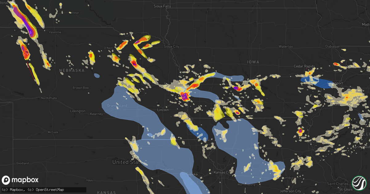
Hail Map on June 25, 2024
Get this storm
June 25 map
$229
one time, instant access
Download today. No call, no setup
Keep the $229
Bought the map and want the full workflow? Apply the entire $229 to a subscription within 7 days. None of it is wasted.
Every map, not just this one
This buys you this map. Subscription and you get every map we run, in the markets you choose from a few cities to whole states to nationwide. Plus real-time alerts the moment a storm fires.
Contact data
Name, contact info, occupancy, even credit band for addresses in the footprint. You go from where it hit to who to call.
Become the source they trust
Unlimited branding weather history reports on demand. You already have the documented answer ready for the property owner, and you are the one who showed up with it.
Property data and RoofTrace estimates
Pull up any address you have got, its value and the exact code rules for that jurisdiction, straight from One Click Code. Then RoofTrace estimates the squares, pitch, and roof value, priced the way you price.
States Impacted by Hail Map on June 25, 2024
Storm reports
Illinois
| Date | Description |
|---|---|
| 06/25/20246:27 PM CDT | Photo shared on social media showed nickel to quarter size hail near south street and franklinville road. Time estimated. |
| 06/25/20246:27 PM CDT | Sproadic tree damage was reported on vermont street. |
| 06/25/20243:00 PM CDT | Em measured wind gust with his anemometer. |
| 06/25/20242:39 PM CDT | Em reported power poles and trees down over the north side of town. Time estimated from radar. |
| 06/25/20242:30 PM CDT | A local report indicates 1.00 inch wind near Mound Station |
| 06/25/20241:57 PM CDT | A local report indicates 1.00 inch wind near Paris |
| 06/25/20241:44 PM CDT | Viewer report relayed by broadcast media. Time estimated via radar. |
| 06/25/20241:44 PM CDT | Viewer photo of shredded corn relayed by broadcast media. Time estimated by radar. |
| 06/25/20241:44 PM CDT | Viewer report relayed by broadcast media. |
| 06/25/20241:31 PM CDT | Large sycamore tree limb down. Time estimated using radar. |
| 06/25/20241:29 PM CDT | Corrects time of previous hail report from paris. |
| 06/25/20241:29 PM CDT | Severe crop damage - leaves missing and crops flattened. 7 trees fell the largest around 3 feet in diameter. Trees fell into power lines knocking out power. Garage buil |
| 06/25/20241:29 PM CDT | A local report indicates 1.25 inch wind near 4 N Oliver |
| 06/25/20241:25 PM CDT | Public report of trees down on vermilion rd... Just north of the lower t relayed by broadcast media. |
| 06/25/20241:25 PM CDT | Time estimated via radar... Relayed by broadcast media. |
| 06/25/20241:25 PM CDT | Public report of several trees down near a farm... Relayed by broadcast media. Time estimated from radar. |
| 06/25/20241:25 PM CDT | Corrects previous tstm wnd dmg report from 2 s paris. Public report of a tree down across route 1 south of paris... Il relayed by broadcast meteorologist. |
| 06/25/20241:13 PM CDT | Tree down on a powerline in campbell. |
| 06/25/20241:10 PM CDT | Mto gust to 58 mph. |
| 06/25/20241:00 PM CDT | A tree branch of approx 4-5 inches snapped off a tree in humboldt. |
| 06/25/202412:05 PM CDT | Tree fell on power pole at e kansas st and s wheeler ave and was reported by power company. |
| 06/25/202411:56 AM CDT | Electrical pole broke. |
| 06/25/202411:50 AM CDT | Measured by anemometer. |
| 06/25/202411:50 AM CDT | Measured wind gust of 60 mph... With 2-3 inch tree limbs... And pea size hail reported by trained spotter. |
| 06/25/202411:27 AM CDT | Pea to quarter size hail reported. |
| 06/25/202411:05 AM CDT | Large tree limb down over a foot in diameter. |
| 06/25/20249:00 AM CDT | Corrects previous tstm wnd dmg report from 3 nnw dahinda. Two large trees blown down causing damage to home. Delayed report. Time approximate. |
| 06/25/20248:50 AM CDT | Delayed report. Large tree limbs down across oak run golf course. |
| 06/25/20248:19 AM CDT | Numerous 4 inch and larger tree limbs down on the south side of the village. |
| 06/25/20248:10 AM CDT | Delayed report. Trees down in galva cemetery. |
| 06/25/20248:05 AM CDT | Time estimated from radar; grain wagons blown over. |
| 06/25/20247:22 AM CDT | Time estimated from radar; trees down at n750th ave and highway 81. |
| 06/25/20247:17 AM CDT | Time estimated from radar; trees down intersection of tower rd and highway 81. |
| 06/25/20247:15 AM CDT | Delayed report. Henry county ema reported multiple power poles leaning and trees down between highway 81 and county road 14. Time estimated by radar. |
| 06/25/20247:14 AM CDT | Large tree down near bolingbrook golf club. |
| 06/25/20247:10 AM CDT | Numerous large limbs near 6 inches in diameter and power line damage from nagle to harlem ave between foster and gunnison in the norwood park neighborhood. |
| 06/25/20247:10 AM CDT | Social media report of inbound trains halted at mayfair due to tree down on the tracks. Time estimated based on radar. |
| 06/25/20247:08 AM CDT | Trees down in the area. |
| 06/25/20247:07 AM CDT | Social media photo of 3-4 inch diameter limb down in the norwood park neighborhood area. |
| 06/25/20247:00 AM CDT | Time estimated from radar; trees down intersection of e2330 street and mud creek rd. |
| 06/24/20249:45 PM CDT | Swop observer reported an estimated 55-60 mph wind gust. |
| 06/24/20249:09 PM CDT | Multiple tree branches broken in pekin... Some as large as 16 inches in diameter. A power pole was also snapped. |
| 06/24/20249:09 PM CDT | A local report indicates 62 MPH wind near 1 SE Pekin |
| 06/24/20249:00 PM CDT | Two large trees blown down causing damage to home. Delayed report. Time approximate. |
| 06/24/20248:58 PM CDT | Tree limbs 4-5 inches in diameter down over road making it impassable. |
| 06/24/20248:50 PM CDT | Tree across the road. |
| 06/24/20248:50 PM CDT | Tree fell on a home. |
| 06/24/20248:46 PM CDT | Measured from a pws. |
| 06/24/20248:45 PM CDT | Cable lines downed. |
| 06/24/20248:34 PM CDT | A local report indicates 64 MPH wind near 2 S Pekin |
| 06/24/20248:34 PM CDT | Corrects previous thunderstorm wind gust report from 2 s pekin. |
| 06/24/20248:34 PM CDT | A local report indicates 64 MPH wind near 2 S Princeville |
| 06/24/20248:20 PM CDT | Large tree and powerlines downed. Time updated. |
| 06/24/20248:19 PM CDT | Tree limbs broken off. Relayed via mping. |
| 06/24/20248:15 PM CDT | Several reports of large tree branches blown down. |
| 06/24/20248:00 PM CDT | Large tree branch down. Time estimated from radar data. |
| 06/24/20247:55 PM CDT | Multiple trees down on route 93 in bradford. |
| 06/24/20247:53 PM CDT | A local report indicates 1.75 inch wind near Altona |
Wisconsin
| Date | Description |
|---|---|
| 06/25/20247:05 AM CDT | Photo of downed tree limbs relayed via broadcast media. Time estimated from radar. |
| 06/24/20247:55 PM CDT | A local report indicates 1.00 inch wind near 4 S Milton |
| 06/24/20247:55 PM CDT | At least 1 stone upward of half dollar size. |
| 06/24/20247:50 PM CDT | Few quarters mostly pea. |
| 06/24/20247:48 PM CDT | Report from mping: quarter |
| 06/24/20247:43 PM CDT | Report from mping: quarter |
Kansas
| Date | Description |
|---|---|
| 06/25/20245:55 PM CDT | A local report indicates 1.25 inch wind near 3 SSW Winfield |
| 06/25/20245:39 PM CDT | Delayed report received via facebook. |
| 06/25/20245:46 AM CDT | Asos station kcfv coffeyville municipal airpt. |
| 06/25/20245:30 AM CDT | Dime size hail along with 70 mph winds. |
| 06/25/20245:21 AM CDT | Emergency manager reports 60 mph wind gusts and heavy rain near highway 7 and 126. |
| 06/25/20244:58 AM CDT | Asos station kcnu chanute martin johnson airpt. |
| 06/25/20244:50 AM CDT | Roof damage to home and tree damage to property. |
| 06/25/20244:38 AM CDT | Iola airport reported a 62 mph wind gust. |
| 06/25/20244:35 AM CDT | Large tree limb down in iola along with some electrical outages. |
| 06/25/20244:25 AM CDT | Delayed report. Emergency manager reported trees and branches down around paola including the town square. Time estimated via radar. |
| 06/25/20244:23 AM CDT | Downed power lines and power outages near 223rd street. Time estimated from radar. |
| 06/25/20244:23 AM CDT | Report from mping: 1-inch tree limbs broken; shingles blown off. |
| 06/25/20244:21 AM CDT | Downed power lines and power outages near flint drive. Time estimated from radar. |
| 06/25/20244:18 AM CDT | Six-inch diameter tree limb downed at a residence near 143rd and pflumm. Time estimated from radar. |
| 06/25/20244:15 AM CDT | Downed tree limbs and wires near antioch road. Time estimated from radar. |
| 06/25/20244:04 AM CDT | Downed tree and wires near 68th street. Time confirmed from radar and based on dispatch report. |
| 06/25/20244:02 AM CDT | Personal weather station. |
| 06/25/20244:00 AM CDT | Downed trees and downed tree branches. |
| 06/25/20243:56 AM CDT | Personal weather station. |
| 06/25/20243:56 AM CDT | Large limb of tree |
| 06/25/20243:52 AM CDT | Large branches snapped in the indian hills area of lawrence. Time estimated by radar. |
| 06/25/20243:45 AM CDT | Large portions of trees down between melvern and quenemo. |
| 06/25/20243:44 AM CDT | Personal weather station. |
| 06/25/20243:43 AM CDT | Report from mping: 3-inch tree limbs broken; power poles broken. |
| 06/25/20243:40 AM CDT | Via social media... 8 inch tree limb down... Damage to large cottonwood tree with various limbs down near 45th and gage blvd. Time estimated by radar. |
| 06/25/20243:39 AM CDT | Social media report of large tree branches down in vassar. Time estimated from radar. |
| 06/25/20243:35 AM CDT | Large tree snapped ion osage city. Time estimated from radar. |
| 06/25/20243:30 AM CDT | Report from mping: trees uprooted or snapped; roof blown off. Time adjusted via radar. |
| 06/25/20243:28 AM CDT | Large tree limbs down... Damage to trees. Via social media. Time estimated by radar. |
| 06/25/20243:27 AM CDT | Social media report for multiple uprooted trees... And a large tree snapped at its base. Time estimated by radar. |
| 06/25/20243:26 AM CDT | Public reports tree damage... Power lines down... As well as some structural damage to sheds and carports. |
| 06/25/20243:26 AM CDT | Power line reported down just east of wanamaker rd and 29th street. Time estimated by radar. |
| 06/25/20243:25 AM CDT | 13 inch diameter tree branch down... Fence blown over. |
| 06/25/20243:25 AM CDT | 12 inch diameter tree limb down. |
| 06/25/20243:25 AM CDT | Lost power as well. |
| 06/25/20243:25 AM CDT | Corrects previous tstm wnd gst report from 7 wnw pauline. Lost power as well. |
| 06/25/20243:25 AM CDT | Large diameter tree branch around 24 inches in diameter down in central topeka. Via social media. Time estimated by radar. |
| 06/25/20243:24 AM CDT | Lots of tree damage and power is out. |
| 06/25/20243:23 AM CDT | Corrects previous tstm wnd dmg report from 7 w topeka. Report from mping: 1-inch tree limbs broken; shingles blown off. |
| 06/25/20243:23 AM CDT | Report from mping: 1-inch tree limbs broken; shingles blown off. |
| 06/25/20243:22 AM CDT | Personal weather station. |
| 06/25/20243:22 AM CDT | Corrects previous tstm wnd gst report from 7 wsw topeka. |
| 06/25/20243:22 AM CDT | A local report indicates 65 MPH wind near 7 WSW Topeka |
| 06/25/20243:21 AM CDT | A local report indicates 70 MPH wind near 2 SE Willard |
| 06/25/20243:20 AM CDT | Multiple public reports of significant tree damage in silver lake. Time estimated from radar. |
| 06/25/20243:20 AM CDT | Tree damage across much of the community of silver lake consistent with widespread estimated 70-90 mph wind speeds. |
| 06/25/20243:16 AM CDT | Kstate mesonet. |
| 06/25/20243:15 AM CDT | *** 2 inj *** khp reports a semi was blown off of i-70 due to high winds. Two occupants in the semi were treated for minor injuries. |
| 06/25/20243:13 AM CDT | Large tree limbs broken... Peach tree uprooted. |
| 06/25/20243:12 AM CDT | Personal weather station. |
| 06/25/20243:10 AM CDT | Many trees down around willard. 13-16 inch diameter limbs down as well. Time estimated by radar. |
| 06/25/20243:08 AM CDT | 12 inch diameter tree snapped in maple hill. Time estimated from radar. |
| 06/25/20243:01 AM CDT | Personal weather station. |
| 06/25/20242:59 AM CDT | Small shed lost its roof and was knocked over in wamego. Time estimated from radar. |
| 06/25/20242:59 AM CDT | Personal weather station. |
| 06/25/20242:58 AM CDT | Personal weather station. |
| 06/25/20242:58 AM CDT | Personal weather station. |
| 06/25/20242:55 AM CDT | Social media report shows an 8 inch tree limb down on a home in manhattan. |
| 06/25/20242:55 AM CDT | Downed tree limbs and wires near state line road and 23rd street. Time estimated from radar. |
| 06/25/20242:55 AM CDT | Personal weather station. |
| 06/25/20242:53 AM CDT | Personal weather station. |
| 06/25/20242:52 AM CDT | Large tree snapped at the base. |
| 06/25/20242:50 AM CDT | Personal weather station. |
| 06/25/20242:45 AM CDT | Large tree 2 to 3 feet in diameter downed. Time estimated from radar. |
| 06/25/20242:43 AM CDT | Wooden frame of a 40 by 80 foot building blown over... With one wall remaining. |
| 06/25/20242:40 AM CDT | Union pacific mesonet. |
| 06/25/20242:37 AM CDT | Report from mping: 3-inch tree limbs broken; power poles broken. |
| 06/25/20242:37 AM CDT | Downed tree and wires near 13th terrace. Time based on dispatch report and confirmed from radar. |
| 06/25/20242:36 AM CDT | Clay center awos. |
| 06/25/20242:31 AM CDT | Downed tree and wires near hubbard road. Time estimated from radar. |
| 06/25/20242:28 AM CDT | Tree damage and power lines down. Time estimated from radar. |
| 06/25/20242:28 AM CDT | Kstate mesonet. |
| 06/25/20242:27 AM CDT | Downed tree limbs and wires near hadley avenue. Time based on dispatch report and confirmed from radar. |
| 06/25/20242:23 AM CDT | Downed tree and wires near mill street. Time based on dispatch report and confirmed from radar. |
| 06/25/20242:17 AM CDT | Power lines and tree damage in marysville. Estimated 70 mph wind gust. Time estimated from radar. |
| 06/25/20242:15 AM CDT | Pine tree around 2 feet in diameter snapped at the base in home... Metal outbuilding took damage as well. |
| 06/25/20242:09 AM CDT | Personal weather station. |
| 06/25/20241:49 AM CDT | Kstate mesonet. |
| 06/24/20248:45 PM CDT | A local report indicates 1.00 inch wind near 3 S Elk City |
| 06/24/20248:45 PM CDT | Reported via social media. |
| 06/24/20248:44 PM CDT | Stones had been sitting in yard for a time... But measured 1.5 - 2 inches in diameter. |
| 06/24/20248:32 PM CDT | Reported via social media. |
South Carolina
| Date | Description |
|---|---|
| 06/25/20244:54 PM CDT | A colleton county emergency manager reported a tree down near the intersection of can city road and mount carmel road. |
Michigan
| Date | Description |
|---|---|
| 06/25/20248:00 AM CDT | Report via facebook- limbs downed in the au gres area from gusty winds on backside of line of storms around 9am. |
| 06/25/20247:42 AM CDT | Tree down on power lines. |
| 06/25/20247:24 AM CDT | 1 foot diameter tree covering road. |
South Dakota
| Date | Description |
|---|---|
| 06/25/20246:57 PM CDT | Windows broken on mobile home due to wind driven hail. |
| 06/25/20246:55 PM CDT | A local report indicates 1.00 inch wind near 9 SSE Potato Creek |
| 06/25/20246:55 PM CDT | Wind driven quarter sized hail broke house and car windows. Uprooted trees. |
| 06/25/20246:41 PM CDT | A local report indicates 67 MPH wind near 4 E Cactus Flat |
| 06/25/20246:40 PM CDT | Roof blown off house. |
| 06/25/20246:40 PM CDT | Mobile home rolled over. |
| 06/25/20246:30 PM CDT | Baseball to softball size hail caused significant damage to spotters vehicle. |
| 06/25/20246:16 PM CDT | A local report indicates 1.00 inch wind near 7 SW Rapid City Arpt |
| 06/25/20246:06 PM CDT | Mping report |
| 06/25/20246:05 PM CDT | A local report indicates 1.00 inch wind near 4 SSW Dwtn RAPID CITY |
| 06/25/20246:04 PM CDT | Mping report |
| 06/25/20246:03 PM CDT | Mping report |
| 06/25/20246:02 PM CDT | A local report indicates 1.50 inch wind near 4 S Dwtn Rapid City |
| 06/25/20245:47 PM CDT | A local report indicates 1.25 inch wind near 1 NNW Hisega |
| 06/25/20245:15 PM CDT | Lasted 10 minutes |
| 06/25/20245:10 PM CDT | A local report indicates 60 MPH wind near 4 NW Creighton |
| 06/25/20245:09 PM CDT | Trees uprooted. Kennel blown away. |
| 06/25/20245:09 PM CDT | Trees uprooted. Kennel blown away. |
| 06/25/20245:09 PM CDT | Trees uprooted. Kennel blown away. |
| 06/25/20244:44 PM CDT | A local report indicates 60 MPH wind near 1 N Hereford |
| 06/25/20244:27 PM CDT | A local report indicates 60 MPH wind near 1 SE Union Center |
| 06/24/20248:44 PM CDT | A local report indicates 67 MPH wind near 15 SSE Mission |
| 06/24/20248:40 PM CDT | A local report indicates 77 MPH wind near 7 ESE Rosebud |
| 06/24/20248:11 PM CDT | A local report indicates 69 MPH wind near 11 SW Parmelee |
| 06/24/20248:06 PM CDT | A local report indicates 61 MPH wind near 11 SW Parmelee |
| 06/24/20247:35 PM CDT | Multiple windows broken downtown. Power pole damage caused power outage in martin. |
| 06/24/20247:35 PM CDT | Multiple windows broken downtown. Power pole damage caused power outage in martin. |
| 06/24/20247:35 PM CDT | A local report indicates 60 MPH wind near 1 ESE Martin |
| 06/24/20247:33 PM CDT | A local report indicates 1.75 inch wind near 4 NNE Long Valley |
| 06/24/20247:30 PM CDT | Baseball to softball size hail caused significant damage to spotters vehicle. |
| 06/24/20247:29 PM CDT | Mping report |
| 06/24/20247:20 PM CDT | A local report indicates 71 MPH wind near 1 ESE Martin |
Missouri
| Date | Description |
|---|---|
| 06/25/20246:47 PM CDT | Report of roof damage to mobile home and large tree limbs down. |
| 06/25/20246:37 PM CDT | Weak tree snapped at the base at cooperative way south of 70. Time estimated from radar. Photo from social media. |
| 06/25/20246:15 PM CDT | Delayed report. Via social media pics a large tree that fell on a house. Time based on radar estimate. |
| 06/25/20246:02 PM CDT | Boone county 911 relayed video of a large tree that was down on a parked car near st. Charles road and clark lane on the northeast side of columbia. Time estimated by r |
| 06/25/20246:02 PM CDT | Siding reported blown off a church 5 miles south of the mexico airport. |
| 06/25/20246:02 PM CDT | Large tree down on jefferson street. Time estimated based on radar. |
| 06/25/20246:02 PM CDT | Delayed report. Emergency manager observed estimated quarter sized hail. Time estimated from radar. |
| 06/25/20245:56 PM CDT | Tree and power pole down at the 2100 block of woodlea. Time estimated from radar. |
| 06/25/20245:56 PM CDT | Large tree limb down blocking road at 20 block of austin avenue. Time estimated from radar. |
| 06/25/20245:56 PM CDT | Tree down blocking road... Time estimated from radar. |
| 06/25/20245:49 PM CDT | 5 inch tree limbs down. No power in town. |
| 06/25/20245:46 PM CDT | Trees down and power lines across the county. |
| 06/25/20245:44 PM CDT | Utility company reports power outage caused by tree limbs/debris blown into power lines. |
| 06/25/20245:44 PM CDT | *** 1 fatal *** an old... Dilapidated barn was destroyed along highway 54. A fatality occurred from an individual seeking shelter in the barn prior to its destruction. |
| 06/25/20245:44 PM CDT | Large tree limb blocking road. Time estimated from radar. |
| 06/25/20245:42 PM CDT | Tree down into live power lines. Time estimated from radar. |
| 06/25/20245:40 PM CDT | Roof blown off trailer. Tree limbs blown down. |
| 06/25/20245:34 PM CDT | Downed power pole. |
| 06/25/20245:32 PM CDT | Large tree limb down blocking road. Time estimated from radar. |
| 06/25/20245:30 PM CDT | Tree over highway 54. |
| 06/25/20245:18 PM CDT | A few large mature trees blown down. Several tree limbs have knocked down power lines. |
| 06/25/20245:12 PM CDT | A few large trees and limbs down in vandalia. |
| 06/25/20245:07 PM CDT | Large tree down across road at hwy 124 and 101. Multiple reports of tree damage and power outages around fayette... Mo. Time estimated via radar. |
| 06/25/20244:37 PM CDT | Utility company reports outage due to tree limbs/debris blown into power lines. |
| 06/25/20244:03 PM CDT | Delayed report. Multiple large branches across roadway into wooldridge. Time estimated via radar. |
| 06/25/20243:55 PM CDT | Several limbs down and a tree down in the squires area including the highway jj area. |
| 06/25/20243:50 PM CDT | Several trees down on a highway south of ava and northwest of squires. |
| 06/25/202412:25 PM CDT | Large tree blown down over highway 15. In addition... A portable shed blow from parking lot of store... Onto a highway... Where it was hit by a truck and destroyed. Pho |
| 06/25/20246:14 AM CDT | Roof blown off building. |
| 06/25/20246:14 AM CDT | Report from emergency manager of a 59 mph wind gusts. Additional reports of some tree damage and power outages northeast of neosho. Time estimated from radar. |
| 06/25/20246:07 AM CDT | Large limb downed. |
| 06/25/20245:55 AM CDT | Trees down near house. |
| 06/25/20245:52 AM CDT | Multiple large tree limbs downed in the marshfield area. |
| 06/25/20245:50 AM CDT | Large tree limb downed. |
| 06/25/20245:48 AM CDT | Report of a tree down at mccoy and b on the northside of joplin. Time estimated from radar. |
| 06/25/20245:42 AM CDT | Delayed report. A few sizeable trees down in willard by the golf course. Time based on radar estimate. |
| 06/25/20245:30 AM CDT | Report of multiple trees down in the walnut grove area with power outages. |
| 06/25/20245:23 AM CDT | Broadcast media relayed report of downed tree limbs at a home in morrisville. Time estimated from radar. |
| 06/25/20245:04 AM CDT | Corrects previous tstm wnd dmg report from 3 nne bolivar. A church complex suffered damage to a southeast facing exterior brick wall and interior sections of a church b |
| 06/25/20244:39 AM CDT | Report from mping: 1-inch tree limbs broken in el dorado springs area. Time estimated from radar. |
| 06/25/20244:39 AM CDT | Downed wires and power outages near 215th street. Time estimated from radar. |
| 06/25/20244:36 AM CDT | Downed wires and power outages near 223rd street. Time estimated from radar. |
| 06/25/20244:04 AM CDT | A church complex suffered damage to a southeast facing exterior brick wall and interior sections of a church building... As well as roof damage and collapse of an inter |
| 06/25/20243:14 AM CDT | Downed tree and wires near grover street. Time estimated from radar. |
| 06/25/20242:55 AM CDT | Downed power lines and power outages near route 2. Time estimated from radar. |
| 06/25/20242:55 AM CDT | Downed power lines and power outages near route bb. Time estimated from radar. |
| 06/25/20242:46 AM CDT | Multiple trees and limbs down near the nws office. Time estimated from radar. |
| 06/25/20242:36 AM CDT | Downed wires and power outages near county road 2250. Time estimated from radar. |
| 06/25/20242:36 AM CDT | Downed wires and power outages near 1901st road. Time estimated from radar. |
| 06/25/20242:32 AM CDT | Downed tree limbs and wires near moats avenue. Time estimated from radar. |
| 06/25/20242:32 AM CDT | Downed wires and power outages near forest street. Time estimated from radar. |
| 06/25/20242:27 AM CDT | Downed tree limbs and wires near madison street. Time estimated from radar. |
| 06/25/20242:27 AM CDT | Corrects previous tstm wnd dmg report from 2 ne avondale. Downed tree limbs and wires in winnwood park. Time estimated from radar. |
| 06/25/20242:27 AM CDT | Sustained wind gusts of 50-60mph reported by amateur radio along 13 highway. Time estimated from radar. |
| 06/25/20242:22 AM CDT | Downed power lines and power outages near carlisle avenue. Time estimated from radar. |
| 06/25/20242:22 AM CDT | Downed tree limbs and wires near marilynn avenue. Time estimated from radar. |
| 06/25/20242:18 AM CDT | Downed tree limbs and wires in winnwood park. Time estimated from radar. |
| 06/25/20242:18 AM CDT | Downed wires and power outages near mersington avenue. Time estimated from radar. |
| 06/25/20242:12 AM CDT | Downed power lines and power outages near route 213. Time estimated from radar. |
| 06/25/20242:08 AM CDT | Downed tree limbs and wires near nw 48th street. Time estimated from radar. |
| 06/25/20242:07 AM CDT | Downed tree limbs and wires near merrimac avenue. Time estimated from radar. |
| 06/25/20242:00 AM CDT | Multiple small trees and limbs blown down in excelsior springs. Time estimated from radar. |
| 06/25/20242:00 AM CDT | Downed power lines near elm park road. Time estimated from radar. |
| 06/25/20241:50 AM CDT | Downed tree limbs and wires near depot street. Time estimated from radar. |
| 06/25/20241:50 AM CDT | Downed tree and wires near 4th street and delaware street. Time estimated from radar. |
| 06/25/20241:31 AM CDT | Downed tree limbs and wires near saxton easton road. Time estimated from radar. |
| 06/25/20241:31 AM CDT | Several reports of power outages in st. Joseph... With a few reports of downed wires. Time estimated from radar. |
| 06/25/20241:28 AM CDT | Trees down in savanah. |
| 06/25/20241:18 AM CDT | Downed power lines near glade road. Time estimated from radar. |
| 06/25/20241:13 AM CDT | Strong winds estimated at 50-60mph from velocity data observed in fillmore. Andrew county dispatch reported tree limbs down around the area. Time estimated from radar. |
| 06/25/202412:48 AM CDT | Strong winds estimated at 50-60mph reported in chillicothe. Time estimated from radar. |
| 06/25/202412:40 AM CDT | Trees down in savanah. |
| 06/25/202412:40 AM CDT | Downed wires and power outages near 1st avenue. Time estimated from radar. |
| 06/25/202412:32 AM CDT | Downed tree limbs and wires near u.s. Highway 59. Time estimated from radar and dispatch reports. |
| 06/25/202412:26 AM CDT | Strong winds... Heavy... Blinding rain reported by holt county dispatch. Wind gusts estimated between 50-60mph. Time estimated from radar. |
| 06/25/202412:25 AM CDT | Grundy county emergency manager reported numerous power outages. Velocity data estimates winds gusts of 50-60mph. Time estimated from radar. |
| 06/25/202412:24 AM CDT | Private weather station measured a 76 mph gust at 1224 am. |
| 06/25/202412:18 AM CDT | A local report indicates 60 MPH wind near Spickard |
| 06/25/202412:00 AM CDT | Downed trees and wires near burrows avenue. Time estimated from radar. |
| 06/24/202411:56 PM CDT | Numerous reports of power outages on the east side of bethany... Mo. Sheriff along with local utility companies are investigating the outages. Wind gusts from storms mo |
| 06/24/202411:51 PM CDT | Reports of trees down on powerlines and a transformer reportedly blown. Winds gusts estimated at 65-70mph. Information from gentry county dispatch. Time estimated from |
| 06/24/202411:38 PM CDT | Intense winds ranging from 50-60mph reported by worthy county law enforcement at mozingo lake. Time estimated from radar. |
| 06/24/202411:38 PM CDT | Downed power lines and power outages near fillmore street. Time estimated from radar. |
| 06/24/202411:14 PM CDT | Downed power lines and power outages near 120th street. Time estimated from radar. |
| 06/24/202410:15 PM CDT | Numerous trees and powerlines down around jackson and cape girardeau. |
| 06/24/20249:58 PM CDT | 6-inch diameter branch downed. Time estimated by radar. |
| 06/24/20249:38 PM CDT | One tree down and numerous large branches down at the castor river campground. |
| 06/24/20249:17 PM CDT | Trees down and power out in marquand. |
| 06/24/20249:04 PM CDT | Delayed report. Volunteer fire fighter recorded 60 mph gust on personal weather station. Time estimated via radar. |
| 06/24/20249:04 PM CDT | Delayed report from the utility company. 5 power poles downed and/or damaged between glenwood and lancaster. Time estimated from radar. |
| 06/24/20249:03 PM CDT | Delayed report. Broadcast media reported multiple large tree limbs down around the lancaster area. Time estimated via radar. |
| 06/24/20248:39 PM CDT | A local report indicates 60 MPH wind near 1 WNW Alexandria |
| 06/24/20247:44 PM CDT | Couple of trees down on highway 34 at the reynolds-wayne county line. |
| 06/24/20247:13 PM CDT | Broke windshields in williamstown. |
Texas
| Date | Description |
|---|---|
| 06/25/20246:13 PM CDT | Report from mping: quarter |
| 06/25/20246:09 PM CDT | Corrects previous tstm wnd dmg report from 19 nnw codman. Video received via social media of large healthy tree snapped at base along hwy 70 near chicken creek north of |
| 06/25/20246:09 PM CDT | Video received via social media of large healthy tree snapped at base along hwy 70 near chicken creek... North of pampa. Time estimated based on radar. |
| 06/24/20249:11 PM CDT | Report from mping: 1-inch tree limbs broken; shingles blown off. |
| 06/24/20249:07 PM CDT | West texas mesonet. |
| 06/24/20248:03 PM CDT | Picture of large healthy tree branch approximately 1 foot in diameter snapped off tree at ne 14th and n spring st. Report received via social media. Time estimated base |
| 06/24/20247:45 PM CDT | Picture of a large tree knocked over in downtown at 10th and fillmore. Local broadcast media report received via slack. |
| 06/24/20247:42 PM CDT | Mesonet recorded gust of 60 mph at 7:42 pm then subsided. Event was still ongoing at time of report. |
| 06/24/20247:37 PM CDT | Corrects previous tstm wnd gst report from 6 ene amarillo. Multiple peak wind gusts of 78 mph with other severe gusts occurring between 715 pm and time of report. |
| 06/24/20247:37 PM CDT | Multiple peak wind gusts of 78 mph... With other severe gusts occurring between 7:15 pm and time of report. |
| 06/24/20247:36 PM CDT | Public report of semi blown over on westbound i-40 at airport blvd. |
| 06/24/20247:15 PM CDT | Picture of power pole snapped along ne 24th ave in front of the clements unit received via social media. Time estimated based on radar. |
| 06/24/20247:10 PM CDT | Mesonet recorded peak gust of 79mph at 7:10 pm... With other severe gusts occurring from 6:55 to 7:20 pm. |
| 06/24/20247:10 PM CDT | Corrects previous tstm wnd gst report from 9 n amarillo. Mesonet recorded peak gust of 79 mph at 710 pm with other severe gusts occurring from 655 pm to 720 pm. |
Nebraska
| Date | Description |
|---|---|
| 06/25/20246:57 PM CDT | A local report indicates 2.00 inch wind near 2 S Papillion |
| 06/25/20246:56 PM CDT | Off duty nws employee reported a brief tornado touchdown north of highway 32 and just east of 543rd. |
| 06/25/20246:55 PM CDT | Report from mping: quarter |
| 06/25/20246:52 PM CDT | Tornado on ground briefly at 652pm. |
| 06/25/20246:52 PM CDT | Delayed report.... |
| 06/25/20246:50 PM CDT | A local report indicates 1.50 inch wind near 1 NE Offutt Afb |
| 06/25/20246:47 PM CDT | Report from mping: quarter |
| 06/25/20246:46 PM CDT | Report from mping: quarter |
| 06/25/20246:45 PM CDT | Report from mping: quarter |
| 06/25/20246:45 PM CDT | A local report indicates 2.50 inch wind near 3 S Meadow Grove |
| 06/25/20246:38 PM CDT | Report from mping: quarter |
| 06/25/20246:36 PM CDT | A local report indicates 1.00 inch wind near 3 WSW Bellevue |
| 06/25/20246:35 PM CDT | Report from mping: half dollar |
| 06/25/20246:35 PM CDT | A local report indicates 2.00 inch wind near Meadow Grove |
| 06/25/20246:30 PM CDT | Delayed report. |
| 06/25/20246:30 PM CDT | A local report indicates 1.75 inch wind near 2 SE Seneca |
| 06/25/20246:26 PM CDT | Report from mping: quarter |
| 06/25/20246:18 PM CDT | Report from mping: quarter |
| 06/25/20246:16 PM CDT | A local report indicates 1.00 inch wind near 4 E Omaha |
| 06/25/20246:14 PM CDT | A local report indicates a tornado near 3 S Meadow Grove |
| 06/25/20246:12 PM CDT | Report from mping: golf ball |
| 06/25/20246:11 PM CDT | Delayed report. |
| 06/25/20246:10 PM CDT | Report from mping: baseball |
| 06/25/20246:10 PM CDT | Report from mping: hen egg |
| 06/25/20246:10 PM CDT | A local report indicates 2.50 inch wind near 3 E Papillion |
| 06/25/20246:10 PM CDT | A local report indicates 1.75 inch wind near 5 S Ewing |
| 06/25/20246:07 PM CDT | Report from mping: half dollar |
| 06/25/20246:07 PM CDT | Report from mping: half dollar |
| 06/25/20246:07 PM CDT | Shattered windshield. |
| 06/25/20246:06 PM CDT | Report from mping: quarter |
| 06/25/20246:06 PM CDT | Report from mping: quarter |
| 06/25/20246:06 PM CDT | Report from mping: half dollar |
| 06/25/20246:05 PM CDT | Report from mping: tea cup |
| 06/25/20246:04 PM CDT | Report from mping: half dollar |
| 06/25/20246:04 PM CDT | A local report indicates 3.00 inch wind near La Vista |
| 06/25/20246:03 PM CDT | Report from mping: golf ball |
| 06/25/20246:03 PM CDT | Report from mping: quarter |
| 06/25/20246:02 PM CDT | Report from mping: golf ball |
| 06/25/20246:01 PM CDT | A local report indicates 1.75 inch wind near 1 ENE Papillion |
| 06/25/20246:01 PM CDT | Report from mping: quarter |
| 06/25/20246:00 PM CDT | A local report indicates 1.00 inch wind near Meadow Grove |
| 06/25/20246:00 PM CDT | A local report indicates 3.00 inch wind near 3 SE Meadow Grove |
| 06/25/20245:59 PM CDT | Report from mping: hen egg |
| 06/25/20245:58 PM CDT | A local report indicates 4.50 inch wind near 2 NNW Bellevue |
| 06/25/20245:57 PM CDT | Report from mping: baseball |
| 06/25/20245:57 PM CDT | Report from mping: baseball |
| 06/25/20245:56 PM CDT | A local report indicates 1.50 inch wind near 3 NW Bellevue |
| 06/25/20245:56 PM CDT | A local report indicates 2.00 inch wind near 1 SE La Vista |
| 06/25/20245:55 PM CDT | A local report indicates 1.50 inch wind near 1 NE Offutt Afb |
| 06/25/20245:55 PM CDT | Hail ranging from marble to quarter size. |
| 06/25/20245:54 PM CDT | Report from mping: hen egg+ |
| 06/25/20245:54 PM CDT | Trained spotter reported hail ranging from penny to quarter sized. |
| 06/25/20245:54 PM CDT | Report from mping: quarter |
| 06/25/20245:52 PM CDT | Report from mping: golf ball |
| 06/25/20245:51 PM CDT | Report from mping: quarter |
| 06/25/20245:51 PM CDT | A local report indicates 2.25 inch wind near 2 NE Offutt Afb |
| 06/25/20245:45 PM CDT | A local report indicates 2.00 inch wind near Offutt Afb |
| 06/25/20245:45 PM CDT | A local report indicates 1.00 inch wind near La Vista |
| 06/25/20245:42 PM CDT | A local report indicates 2.50 inch wind near 2 NNW Bellevue |
| 06/25/20245:41 PM CDT | A local report indicates 2.00 inch wind near 2 SE Bellevue |
| 06/25/20245:39 PM CDT | A local report indicates 1.25 inch wind near 1 SSE Bellevue |
| 06/25/20245:36 PM CDT | A local report indicates 1.00 inch wind near Bellevue |
| 06/25/20245:36 PM CDT | A local report indicates 1.00 inch wind near 2 SE Bellevue |
| 06/25/20245:35 PM CDT | A local report indicates 2.00 inch wind near 4 E Ralston |
| 06/25/20245:26 PM CDT | A local report indicates 2.50 inch wind near 4 N Bellevue |
| 06/25/20245:19 PM CDT | At ketv at 10th and pacific. |
| 06/25/20245:12 PM CDT | Report from mping: ping pong ball |
| 06/25/20241:55 AM CDT | A local report indicates 75 MPH wind near Fairbury |
| 06/25/20241:53 AM CDT | A local report indicates 72 MPH wind near 4 ENE Harbine |
| 06/25/20241:53 AM CDT | A local report indicates 66 MPH wind near 2 NNW Beatrice |
| 06/25/20241:51 AM CDT | Personal weather station measured gust. |
| 06/25/20241:48 AM CDT | A local report indicates 83 MPH wind near 3 N Fairbury |
| 06/25/20241:35 AM CDT | A local report indicates 60 MPH wind near 2.57 N Chester |
| 06/25/20241:27 AM CDT | Personal weather station measured wind gust. |
| 06/25/20241:23 AM CDT | Tree damage reported from when the front moved through overnight. Time estimated from radar. |
| 06/25/20241:23 AM CDT | Personal weather station measured wind gust. |
| 06/25/20241:18 AM CDT | Personal weather station measured wind gust. |
| 06/25/202412:54 AM CDT | A local report indicates 65 MPH wind near York |
| 06/25/202412:47 AM CDT | Emergency manager reports a gust to 60 mph near hampton. |
| 06/25/202412:32 AM CDT | Mesonet records a gust of 65 mph. |
| 06/25/202412:32 AM CDT | Asos reports a gust to 60 mph. |
| 06/25/202412:30 AM CDT | Received facebook photos of a few large tree branches downed in town. Time estimated from radar and corresponds to nearby mesonet report of 65 mph wind. |
| 06/25/202412:16 AM CDT | A local report indicates 60 MPH wind near 8 NNE Palmer |
| 06/25/202412:14 AM CDT | Mesonet records a gust to 58 mph. |
| 06/25/202412:13 AM CDT | Personal weather station measured gust. |
| 06/24/202411:32 PM CDT | A local report indicates 1.50 inch wind near 2 S Omaha |
| 06/24/202411:32 PM CDT | A local report indicates 1.25 inch wind near 2 N Ralston |
| 06/24/202411:25 PM CDT | A local report indicates 59 MPH wind near Ord Airport |
| 06/24/202411:10 PM CDT | A local report indicates 1.00 inch wind near 1 NW Elkhorn |
| 06/24/202411:05 PM CDT | Report from mping: 1-inch tree limbs broken; shingles blown off. |
| 06/24/202411:00 PM CDT | Report from mping: quarter |
| 06/24/202410:55 PM CDT | Large tree blown down. |
| 06/24/202410:45 PM CDT | A local report indicates 1.25 inch wind near 1 WNW Valley |
| 06/24/202410:42 PM CDT | A local report indicates 1.00 inch wind near 1 WNW Valley |
| 06/24/202410:29 PM CDT | A local report indicates 1.25 inch wind near 1 NE Humphrey |
| 06/24/202410:25 PM CDT | Report from mping: quarter |
| 06/24/202410:20 PM CDT | A local report indicates 1.00 inch wind near Humphrey |
| 06/24/202410:20 PM CDT | A local report indicates 1.25 inch wind near 2 SSE Washington |
| 06/24/202410:11 PM CDT | Report from mping: quarter |
| 06/24/20249:49 PM CDT | Medium sized tree limbs blown down. Power out. |
| 06/24/20249:49 PM CDT | Power lines blown down. |
| 06/24/20249:38 PM CDT | Measured at the omaha airport. |
| 06/24/20249:36 PM CDT | At omaha eppley airport. |
| 06/24/20249:32 PM CDT | John j pershing road was closed due to downed trees and powerlines. |
| 06/24/20249:31 PM CDT | Report from mping: 3-inch tree limbs broken; power poles broken. |
| 06/24/20249:29 PM CDT | A tree trunk snapped at the base. |
| 06/24/20249:28 PM CDT | Report from mping: 1-inch tree limbs broken; shingles blown off. |
| 06/24/20249:25 PM CDT | Report from mping: 3-inch tree limbs broken; power poles broken. |
| 06/24/20249:23 PM CDT | Report from mping: half dollar |
| 06/24/20249:20 PM CDT | Tornado on the ground 17sse whitman. |
| 06/24/20249:15 PM CDT | Measured by a union pacific weather station. |
| 06/24/20249:05 PM CDT | Baseball sized hail. |
| 06/24/20249:05 PM CDT | A local report indicates 1.75 inch wind near Verdigre |
| 06/24/20249:00 PM CDT | Report from mping: 3-inch tree limbs broken; power poles broken. |
| 06/24/20249:00 PM CDT | Relayed from neighboring weather service office... Storm chaser was located in between mullen and whitman. Location of tornado based on radar. |
| 06/24/20248:56 PM CDT | Emergency manager relayed from sherriff a tornado on the ground half a mile north of whitman. |
| 06/24/20248:40 PM CDT | A few golf ball sized hail... Lots of half dollar. |
| 06/24/20248:36 PM CDT | Report from mping: 3-inch tree limbs broken; power poles broken. |
| 06/24/20248:33 PM CDT | A local report indicates 4.00 inch wind near 17 N Whitman |
| 06/24/20248:25 PM CDT | A local report indicates 1.75 inch wind near 9 SW Verdigre |
| 06/24/20248:18 PM CDT | A local report indicates 3.00 inch wind near 18 NNW Whitman |
| 06/24/20248:17 PM CDT | Report from mping: hen egg |
| 06/24/20248:09 PM CDT | Had a few golf ball size hail... Time estimated off radar. |
| 06/24/20248:02 PM CDT | Roof damage reported. |
| 06/24/20248:00 PM CDT | A local report indicates 2.00 inch wind near Bloomfield |
| 06/24/20247:55 PM CDT | A local report indicates 1.75 inch wind near 2 N Bloomfield |
| 06/24/20247:55 PM CDT | Hail size grew and they had 3 inch hail with estimated 20 mph winds. |
| 06/24/20247:50 PM CDT | Ping pong size hail. |
| 06/24/20247:45 PM CDT | A local report indicates 1.00 inch wind near Bloomfield |
| 06/24/20247:44 PM CDT | From a personal weather station. |
| 06/24/20247:35 PM CDT | A local report indicates 1.00 inch wind near Leigh |
| 06/24/20247:29 PM CDT | Snapped power pole. |
| 06/24/20247:21 PM CDT | A local report indicates 60 MPH wind near 2 S Creston |
| 06/24/20247:05 PM CDT | Report from mping: quarter |
| 06/24/20247:01 PM CDT | A local report indicates 2.50 inch wind near 4 W Offutt Afb |
| 06/24/20247:00 PM CDT | Report from mping: quarter |
Minnesota
| Date | Description |
|---|---|
| 06/25/202410:34 AM CDT | A local report indicates 2.00 inch wind near 3 NW Goodridge |
Oklahoma
| Date | Description |
|---|---|
| 06/25/20245:32 PM CDT | Picture included. |
| 06/25/20245:26 PM CDT | Report from mping: half dollar |
| 06/25/20245:25 PM CDT | A local report indicates 1.50 inch wind near Ponca City |
| 06/25/20245:25 PM CDT | Tree branches down. Guttering ripped off roof. |
| 06/25/20245:23 PM CDT | Report from mping: quarter |
| 06/25/20245:20 PM CDT | Report from mping: half dollar |
| 06/25/20245:19 PM CDT | Report from mping: quarter |
| 06/25/20246:41 AM CDT | A local report indicates 60 MPH wind near Adair |
| 06/25/202412:38 AM CDT | Report from mping. |
| 06/25/202412:33 AM CDT | Report from mping. |
| 06/25/202412:12 AM CDT | Social media image. Radar estimated time. |
| 06/25/202412:10 AM CDT | Report from mping: 3-inch tree limbs broken; power poles broken. |
| 06/24/202411:16 PM CDT | Time estimated. |
| 06/24/202411:09 PM CDT | Report from mping: 3-inch tree limbs broken; power poles broken. |
| 06/24/202411:00 PM CDT | Social media image with ruler measurement. Time is estimated. |
| 06/24/202410:54 PM CDT | Report from mping: ping pong ball |
| 06/24/202410:50 PM CDT | Social media image showing a large tree limb down. Radar estimated time. |
| 06/24/202410:50 PM CDT | Delayed report. Social media image showing a large tree uprooted. Radar estimated time. |
| 06/24/202410:45 PM CDT | Social media image showing the exterior wall of a strip mall collapsed. Radar estimated time. |
| 06/24/202410:43 PM CDT | Multiple social media images showing power poles down near the intersection of air depot and reno. Radar estimated time. |
| 06/24/202410:40 PM CDT | Partial loss of roof covering at the braums at 15th and post. |
| 06/24/202410:30 PM CDT | Delayed report. Tree down on a house. Radar estimated time. |
| 06/24/202410:25 PM CDT | Delayed report. Tree down blocking roadway. Radar estimated time. |
| 06/24/202410:23 PM CDT | Roof damage at office buildings at britton rd and kelley ave. |
| 06/24/202410:19 PM CDT | Power poles down. Time estimated by radar. |
| 06/24/202410:18 PM CDT | Power poles and traffic lights damaged. |
| 06/24/202410:17 PM CDT | Report from mping: 3-inch tree limbs broken; power poles broken. |
| 06/24/202410:17 PM CDT | 3 power poles down. |
| 06/24/202410:12 PM CDT | A local report indicates 1.00 inch wind near 5 NW Edmond |
| 06/24/202410:11 PM CDT | Via social media - tree downed. Time estimated by radar. |
| 06/24/202410:05 PM CDT | Social media image showing multiple power poles snapped. Radar estimated time. |
| 06/24/20249:52 PM CDT | Report from mping: ping pong ball |
| 06/24/20249:46 PM CDT | A local report indicates 66 MPH wind near 2 S Guthrie |
| 06/24/20249:45 PM CDT | Multiple power poles down. Radar estimated time. |
| 06/24/20249:43 PM CDT | A local report indicates 68 MPH wind near 4 SE Guthrie |
| 06/24/20249:40 PM CDT | Relayed images showing large tree limbs down in the twin lakes community. Radar estimated time. |
| 06/24/20249:40 PM CDT | Delayed report. Social media image showing multiple large tree branches down. Radar estimated time. |
| 06/24/20249:40 PM CDT | Social media image showing a large tree uprooted. Radar estimated time. |
| 06/24/20249:35 PM CDT | Power poles down on highway 74c. Radar estimated time. |
| 06/24/20249:35 PM CDT | Relayed image showing a large machine shed destroyed. Radar estimated time. |
| 06/24/20249:35 PM CDT | Torn sheet metal near crescent football field. |
| 06/24/20249:25 PM CDT | A local report indicates 74 MPH wind near 4 SSE Marshall |
| 06/24/20249:20 PM CDT | A local report indicates 76 MPH wind near 4 SSE Marshall |
| 06/24/20249:15 PM CDT | A local report indicates 71 MPH wind near 4 SSE Marshall |
| 06/24/20248:15 PM CDT | A local report indicates 61 MPH wind near 3 NW Stillwater |
| 06/24/20248:10 PM CDT | 50x80 ft. Barn blown over. Lots of down trees. Shingles blown off houses. |
| 06/24/20248:00 PM CDT | Delayed report. Multiple confirmations of wind damage in and near perry. This included trees uprooted and at least one outbuilding destroyed. Social media images also s |
| 06/24/20247:50 PM CDT | Report from mping: ping pong ball |
| 06/24/20247:08 PM CDT | A local report indicates 70 MPH wind near 1 W Sooner Lake |
| 06/24/20247:08 PM CDT | A local report indicates 1.25 inch wind near 1 W Sooner Lake |
| 06/24/20247:07 PM CDT | Damage |
Kentucky
| Date | Description |
|---|---|
| 06/25/20246:55 PM CDT | Tree down on kidville road. Time estimated from radar. |
| 06/25/20246:55 PM CDT | Two trees down on a power line. Time estimated from radar. |
| 06/25/20244:58 PM CDT | Gas station canopy blown over on taylorsville road. |
| 06/25/20244:55 PM CDT | Large tree limbs down. |
| 06/25/20244:36 PM CDT | Trees down at highway 421 and milton bedford pike. |
| 06/25/20244:36 PM CDT | Trees down on power lines at garriott road and garriott court. |
| 06/25/20244:35 PM CDT | Trees down across coopers bottom road. |
| 06/25/20244:30 PM CDT | Downed trees and power lines...reported by dispatch. |
| 06/24/20247:10 PM CDT | Tree down against a power pole between clay city and stanton. 2885 stanton road. Time estimated from radar. |
| 06/24/20247:09 PM CDT | Tree down on flicker road. Time estimated from radar. |
Indiana
| Date | Description |
|---|---|
| 06/25/20244:20 PM CDT | Large tree down on main street between monroe and jefferson. |
| 06/25/20243:33 PM CDT | Delayed report. Numerous trees downed. |
| 06/25/20243:30 PM CDT | Delayed report. Time estimated by radar. Multiple large trees and power lines down in southeast part of the county. Roads are blocked. |
| 06/25/20243:12 PM CDT | Peak wind speed is preliminary. |
| 06/25/20243:06 PM CDT | A tree and tree limbs were blown down by thunderstorm winds. Details are unavailable due to amateur radio conditions. |
| 06/25/20243:06 PM CDT | Three-inch diameter branches were blown down by thunderstorm winds. |
| 06/25/20243:05 PM CDT | Eight-inch tre mo 3907 9157 5 inch tree limbs down. No power in town. |
| 06/25/20243:05 PM CDT | A 2.5-inch diameter healthy tree split due to thunderstorm winds. Time approximated. |
| 06/25/20243:05 PM CDT | A utility line was blown down by thunderstorm winds near 6th street and sycamore street. |
| 06/25/20243:05 PM CDT | Eight-inch tree branches were blown down by thunderstorm winds near the intersection of south olcott boulevard and east moores pike. Pea-size hail accompanied the winds |
| 06/25/20243:05 PM CDT | A tree was blown down by thunderstorm winds at 3rd street and alexander. |
| 06/25/20243:05 PM CDT | A tree and utility lines were downed by thunderstorm winds at state rd 550 near vine street. |
| 06/25/20243:02 PM CDT | Tree branches of unknown size were blown down by thunderstorm winds. |
| 06/25/20243:00 PM CDT | A roof was blown off a garage near the intersection of robinson road and kiewig drive by thunderstorm winds. |
| 06/25/20242:55 PM CDT | A local report indicates 60 MPH wind near 1 SE Bloomington |
| 06/25/20242:52 PM CDT | Report from mping...quarter size hail. |
| 06/25/20242:27 PM CDT | Delayed report. Trees down west of spencer. Time estimated by radar. |
| 06/25/20242:07 PM CDT | Delayed report. Strong sustained wind gusts knocked over corn crop and snapped large old growth trees over plus several large limbs of others landing on power lines wit |
| 06/25/20242:04 PM CDT | Preliminary max gust. |
| 06/25/20242:04 PM CDT | Trees and powerlines down east of lewis township. |
| 06/25/20242:02 PM CDT | Thunderstorm winds have blown off one or more of the following...roof shingles... Branches... Awnings... Fences... And carports onto cars. |
| 06/25/20242:00 PM CDT | A small tree was uprooted and another tree split by thunderstorm winds. Time is approximate. |
| 06/25/20242:00 PM CDT | A large branch was sheared off a a large tree and a large sign in a parking lot near the road edge was blown down as a result of thunderstorm winds. Time is approximate |
| 06/25/20242:00 PM CDT | Thunderstorm winds blew down a tree that is blocking cherrywood street. |
| 06/25/20242:00 PM CDT | Several full grown trees and a flag pole have been blown down by thunderstorm winds. |
| 06/25/20242:00 PM CDT | A tree was blown down by thunderstorm winds and is blocking raymond drive. Time is approximate. |
| 06/25/20241:50 PM CDT | Small branches off trees and pea size hail. |
| 06/25/202411:05 AM CDT | Em reported there were trees down across the county from earlier storms. |
| 06/25/202410:37 AM CDT | Alexandria is closed both directions for a tree across the road on top of a car with occupants inside. Time is roughly approximated. |
| 06/25/20249:26 AM CDT | Large tree downed and several large tree limbs down. Time estimated from radar. |
| 06/25/20249:05 AM CDT | Multiple trees down. Time estimated by radar. |
| 06/25/20249:02 AM CDT | Delayed report. Large tree uprooted. Time estimated from radar. |
| 06/25/20249:02 AM CDT | Delayed report. Large tree uprooted. Time estie branches were blown down by thunderstorm winds near the intersection of south olcott boulevard and east moores pike. Pea-size |
| 06/25/20248:58 AM CDT | Tree down on a house and trees downed on bourbon st. South of the rail road tracks as well. Em reports bourbon is out of power. |
| 06/25/20248:39 AM CDT | Trees down on powerlines... Wb 106 near bremen. Time estimated by radar. |
| 06/25/20248:32 AM CDT | Delayed report. Near new road and us route 31. |
| 06/25/20248:29 AM CDT | Delayed report of a few large tree limbs down on county road 28 between county road 1 and 3. |
| 06/25/20248:29 AM CDT | Large tree blocking 3/4 of the roadway via social media. Time estimated by radar. |
| 06/25/20248:27 AM CDT | Trees and power lines down in green township... Near roosevelt and mulberry road. |
| 06/25/20248:24 AM CDT | Tree downed blocking both lanes near myrtle and kern road. Time estimated from radar. |
| 06/25/20248:22 AM CDT | Trained spotter reported quarter inch hail at i-69 and us-20. |
| 06/25/20248:20 AM CDT | Large tree downed near erie and roger st. Time estimated from radar. |
| 06/25/20248:20 AM CDT | Trees down on pear road. Time estimated from radar. |
| 06/25/20248:15 AM CDT | Tree downed blocking the road on redwood road. Time estimated from radar. |
| 06/25/20248:15 AM CDT | Few trees and large limbs down along with power lines down in lagrange county. Approx 350-400 customers without power. Time estimated by radar. |
Alabama
| Date | Description |
|---|---|
| 06/25/20243:57 AM CDT | Report of a few trees down and power outages in the area along highway 79 north of valley crest drive. Time estimated by radar. |
Arizona
| Date | Description |
|---|---|
| 06/24/202410:40 PM CDT | Mesonet station kp03 cochise college airport. |
| 06/24/20249:35 PM CDT | Palo verde tree uprooted due to strong winds from outflow boundary. Wind gusts were estimated at 40-50 mph based on nearby surface observations. |
| 06/24/20248:15 PM CDT | ***delayed report*** 1 to 1.5 inch diameter tree branch snapped from strong winds from an outflow boundary. Wind gusts were estimated at between 40-50 mph based on near |
Iowa
| Date | Description |
|---|---|
| 06/25/20246:50 PM CDT | A local report indicates 1.00 inch wind near 3 ESE Crescent |
| 06/25/20246:50 PM CDT | Spotter reported brief touchdown north of patterson. |
| 06/25/20246:43 PM CDT | Brief tornado... Dropping up and down near 105th ave and timberview. |
| 06/25/20246:40 PM CDT | Photo on social media. Time estimated from radar data. |
| 06/25/20246:35 PM CDT | Quarter hail and a wind gust of 40 mph. |
| 06/25/20246:34 PM CDT | Public report of quarter hail. |
| 06/25/20246:34 PM CDT | Time estimated from radar. |
| 06/25/20246:33 PM CDT | Time estimated from radar. |
| 06/25/20246:31 PM CDT | Location estimated. |
| 06/25/20246:30 PM CDT | Report relayed by media. Photo confirmed. |
| 06/25/20246:30 PM CDT | Wind has snapped several significant tree branches off. |
| 06/25/20246:30 PM CDT | Corrects previous hail report from 4 e maquoketa. |
| 06/25/20246:15 PM CDT | Report from mping: quarter |
| 06/25/20246:14 PM CDT | Tree fell on an lp tank causing it to leak. Power line was also downed near the tree damage. Time estimated by radar. |
| 06/25/20246:09 PM CDT | A local report indicates 1.25 inch wind near 1 E Hartford |
| 06/25/20245:52 PM CDT | Large tree branches down. Time estimated from radar data. |
| 06/25/20245:50 PM CDT | Efu landspout tornado touched down in a field resulting in minor crop damage. |
| 06/25/20245:50 PM CDT | Time estimated. |
| 06/25/20245:50 PM CDT | Public safety reported quarter size hail northeast of runnells. |
| 06/25/20245:46 PM CDT | Wind damage |
| 06/25/20245:38 PM CDT | Tornado touch down in open field. Pictured in social media. |
| 06/25/20245:30 PM CDT | Nearly stationary efu landspout tornado touched down in a field resulting in minor crop damage. |
| 06/25/20245:28 PM CDT | Multiple reports of a tornado on the ground kicking up dust north of ely. |
| 06/25/20245:25 PM CDT | Nws storm survey determined an ef0 tornado with landspout characteristics occurred with maximum winds near 85 mph. Damage included snapped large tree limbs... Damaged p |
| 06/25/20245:24 PM CDT | Large branch out of the top of a healthy walnut tree. Approximately 25 long and 10+ inch diameter. Time estimated by radar. |
| 06/25/20245:15 PM CDT | Delayed report via two social media reports. |
| 06/25/20245:15 PM CDT | Delayed report via two social media reports. |
| 06/25/20245:11 PM CDT | Tree limbs blown onto highway 64. Time estimated by radar. |
| 06/25/20245:05 PM CDT | Jackson county dispatch reported steel roof was blown off a barn north of preston. There was also damage to a high voltage line reported. Possible tornado damage. Time |
| 06/25/20245:03 PM CDT | Nws storm survey determined an ef1 tornado occurred with maximum winds near 100 mph. This tornado damaged outbuildings... Trees... And crops. |
| 06/25/20244:32 PM CDT | Confirmed tornado by fire chief. Time estimated. |
| 06/25/202410:40 AM CDT | A local report indicates 1.00 inch wind near 2 ESE Bentonsport/Verno |
| 06/24/202411:48 PM CDT | A local report indicates 59 MPH wind near 2 ENE Lamoni |
| 06/24/202410:54 PM CDT | Report from mping: 3-inch tree limbs broken; power poles broken. |
| 06/24/202410:54 PM CDT | Report from mping: 3-inch tree limbs brok |
| 06/24/202410:44 PM CDT | Quarter to 2.25 inch diameter hail. Six minutes of hail from north at 1044 to 1050pm. Small twigs broken off. |
| 06/24/202410:20 PM CDT | 62 mph recorded wind gust on handheld anemometer. Blinding rain sheets. |
| 06/24/202410:17 PM CDT | Report from mping: 1-inch tree limbs broken; shingles blown off. |
| 06/24/202410:05 PM CDT | Corrects previous tstm wnd dmg report from oakland. 3 very large tree limbs blown down. Numerous other trees blown down. |
| 06/24/202410:05 PM CDT | 3 tree limbs blown down. |
| 06/24/202410:04 PM CDT | From a personal weather station. |
| 06/24/202410:02 PM CDT | Report from mping: 3-inch tree limbs broken; power poles broken. |
| 06/24/202410:00 PM CDT | Storm siren pole knocked down and tree limb damage. |
| 06/24/20249:59 PM CDT | From a personal weather station. |
| 06/24/20249:46 PM CDT | Portion of dogwood rd closed due to downed trees and powerlines. |
| 06/24/20249:46 PM CDT | From a personal weather station. |
| 06/24/20249:40 PM CDT | From a personal weather station. |
| 06/24/20249:38 PM CDT | Birdsley rd closed due to downed trees and powerlines. |
| 06/24/20249:03 PM CDT | A local report indicates 1.00 inch wind near Audubon |
| 06/24/20248:50 PM CDT | Measured by personal weather station. |
| 06/24/20248:49 PM CDT | Lawn furniture being tossed around. Also very heavy rain. |
| 06/24/20248:34 PM CDT | Several trees and power lines down. Time estimated by radar. |
| 06/24/20248:15 PM CDT | 4 inch tree branch downed by storm winds. |
| 06/24/20248:14 PM CDT | Report from mping: ping pong ball |
| 06/24/20248:06 PM CDT | A 72 mph wind gust was measured on a personal weather station 2 miles east of harlan. |
| 06/24/20248:06 PM CDT | A 72 mph wind gust was measured on a personal weather station 2 miles east of harlan. |
| 06/24/20248:05 PM CDT | A local report indicates 1.75 inch wind near Harlan |
| 06/24/20248:03 PM CDT | A 62 mph wind gust was recorded on a personal weather station on the northwest side of harlan. |
| 06/24/20248:00 PM CDT | From who tv. |
| 06/24/20248:00 PM CDT | A local report indicates 1.50 inch wind near Missouri Valley |
| 06/24/20247:58 PM CDT | Public reported golf ball sized hail on the northern edge of winterset. Submitted picture via social media. |
| 06/24/20247:57 PM CDT | Ping pong hail in winterset. |
| 06/24/20247:56 PM CDT | A local report indicates 2.50 inch wind near 5 S Earlham |
| 06/24/20247:54 PM CDT | From who tv viewer. |
| 06/24/20247:40 PM CDT | Measured from equipment on top of the car. Location of gust is estimated. |
| 06/24/20247:40 PM CDT | A local report indicates 1.00 inch wind near 1 ENE Shelby |
| 06/24/20247:39 PM CDT | Estimated thunderstorm wind gust. |
| 06/24/20247:35 PM CDT | Estimated thunderstorm wind gust. |
| 06/24/20247:35 PM CDT | Estimated thunderstorm wind gusts. Location of the event is estimated. |
| 06/24/20247:35 PM CDT | Widespread tree limbs down in muscatine as well as power poles down. |
| 06/24/20247:30 PM CDT | 5 large trees and many branches downed at saulsbury bridge recreation area. One tree took down a powerline. Time estimated by radar. |
| 06/24/20247:20 PM CDT | Relay of a public report of dime to quarter size hail southeast of keosauqua. |
| 06/24/20247:18 PM CDT | Time estimated from radar. |
| 06/24/20247:06 PM CDT | Power lines down with power outages around dodge street. Time estimated from radar. |
| 06/24/20247:04 PM CDT | From woi tv/local 5. |
| 06/24/20247:03 PM CDT | Asos station kiow iowa city arpt. |
| 06/24/20247:02 PM CDT | Report from mping: quarter |
| 06/24/20247:02 PM CDT | A local report indicates 1.00 inch wind near 1 E North Liberty |
| 06/24/20247:00 PM CDT | Em relayed a report of a window blown out of a home. Rain spilled through the window and flooded the basement. |
Ohio
| Date | Description |
|---|---|
| 06/25/20248:27 AM CDT | Large tree limbs down 6 to 8 inches in diameter. Time estimated from radar. |
| 06/25/20248:08 AM CDT | Damage to a roof at a residence on county road l. |
Cities Impacted by Hail Map on June 25, 2024
- Whitehall, MI
- Holton, MI
- Muskegon, MI
- Twin Lake, MI
- Montague, MI
- Newaygo, MI
- Fremont, MI
- Grant, MI
- Conklin, MI
- Fenwick, MI
- Rockford, MI
- Fruitport, MI
- Ravenna, MI
- Sparta, MI
- Kent City, MI
- Greenville, MI
- Casnovia, MI
- Sand Lake, MI
- Bailey, MI
- Cedar Springs, MI
- Gowen, MI
- Lowell, MI
- Wayland, MI
- Saugatuck, MI
- Nunica, MI
- Marne, MI
- Hopkins, MI
- Zeeland, MI
- Orleans, MI
- Fennville, MI
- Allendale, MI
- Grandville, MI
- Jenison, MI
- West Olive, MI
- Wyoming, MI
- Caledonia, MI
- Spring Lake, MI
- Dorr, MI
- Byron Center, MI
- Holland, MI
- Allegan, MI
- Belmont, MI
- Grand Rapids, MI
- Comstock Park, MI
- Grand Haven, MI
- Coopersville, MI
- Macatawa, MI
- Belding, MI
- Hudsonville, MI
- Hamilton, MI
- Ada, MI
- Saranac, MI
- Freeport, MI
- Alto, MI
- Ionia, MI
- Lake Odessa, MI
- Middleville, MI
- Portland, MI
- Clarksville, MI
- Hastings, MI
- Shelbyville, MI
- Thomson, IL
- Mount Carroll, IL
- West Branch, IA
- Tipton, IA
- Monroe Center, IL
- Davis Junction, IL
- Kewanee, IL
- Annawan, IL
- Sheffield, IL
- Earlville, IL
- Sterling, IL
- Atalissa, IA
- Chadwick, IL
- Lanark, IL
- Cambridge, IL
- Atkinson, IL
- Geneseo, IL
- Oregon, IL
- Leaf River, IL
- Stillman Valley, IL
- Lindenwood, IL
- Kirkland, IL
- Esmond, IL
- Athens, MI
- Union City, MI
- East Leroy, MI
- Marcellus, MI
- Decatur, MI
- Schoolcraft, MI
- Lawton, MI
- Riverside, IA
- North Aurora, IL
- Aurora, IL
- Watervliet, MI
- Kalona, IA
- Wellman, IA
- Bangor, MI
- Covert, MI
- Milledgeville, IL
- Mchenry, IL
- Polo, IL
- Mount Morris, IL
- Forreston, IL
- Buda, IL
- Kingston, IL
- Chicago, IL
- Lone Tree, IA
- Woodstock, IL
- Galva, IL
- Jackson, MI
- West Liberty, IA
- Grass Lake, MI
- Bennett, IA
- Union, IL
- Marengo, IL
- Huntley, IL
- Wonder Lake, IL
- Dixon, IL
- Neponset, IL
- Sherwood, MI
- Mineral, IL
- Wyanet, IL
- Murray, IA
- Sycamore, IL
- Clare, IL
- Byron, IL
- Plainfield, IL
- Naperville, IL
- Oswego, IL
- Yorkville, IL
- Coloma, MI
- Hartford, MI
- Leland, IL
- Sherrard, IL
- Bishop Hill, IL
- Eau Claire, MI
- Sodus, MI
- Genoa, IL
- Manchester, MI
- Crystal Lake, IL
- Chelsea, MI
- Clarklake, MI
- Brooklyn, MI
- Bradford, IL
- Altona, IL
- Tiskilwa, IL
- Toulon, IL
- Woodhull, IL
- Dowagiac, MI
- Berrien Center, MI
- Franklin Grove, IL
- La Grange, IL
- Amboy, IL
- La Moille, IL
- Sublette, IL
- West Brooklyn, IL
- Morrison, IL
- Cassopolis, MI
- Compton, IL
- Spring Grove, IL
- Iowa City, IA
- Bronson, MI
- Holcomb, IL
- Benton Harbor, MI
- Addison, MI
- Cement City, MI
- Burbank, IL
- Justice, IL
- Willow Springs, IL
- Vandalia, MI
- Rochelle, IL
- Niles, MI
- Berrien Springs, MI
- Island Lake, IL
- Antioch, IL
- Alexis, IL
- Lynn Center, IL
- Newark, IL
- Salem, WI
- Trevor, WI
- Wauconda, IL
- Round Lake, IL
- Cary, IL
- Grayslake, IL
- Barrington, IL
- Ashton, IL
- Thayer, IA
- Steward, IL
- Bolingbrook, IL
- Twin Lakes, WI
- Richmond, IL
- Orland, IN
- Howe, IN
- Jones, MI
- White Pigeon, MI
- Oneida, IL
- New Boston, IL
- Joy, IL
- Seaton, IL
- Edwardsburg, MI
- Evergreen Park, IL
- Keota, IA
- Aledo, IL
- Little York, IL
- Shorewood, IL
- Minooka, IL
- Union, MI
- Lagrange, IN
- La Fayette, IL
- Mendota, IL
- Bristol, IN
- Joliet, IL
- Galesburg, IL
- Rio, IL
- Lake Villa, IL
- West Chester, IA
- Washington, IA
- Angola, IN
- Buchanan, MI
- Henderson, IL
- Wataga, IL
- Orion, IL
- Walkerton, IN
- Gerlaw, IL
- Ottawa, IL
- Wolcottville, IN
- La Salle, IL
- Peru, IL
- Utica, IL
- Serena, IL
- Hudson, IN
- South Bend, IN
- North Liberty, IN
- Wauseon, OH
- Delta, OH
- Wyoming, IL
- Elkhart, IN
- Osceola, IN
- Granger, IN
- Mishawaka, IN
- Victoria, IL
- Goshen, IN
- Seneca, IL
- Wedron, IL
- Wakarusa, IN
- Marseilles, IL
- Speer, IL
- Middlebury, IN
- Alpha, IL
- Pleasant Lake, IN
- Lakeville, IN
- Bremen, IN
- Ligonier, IN
- Hamlet, IN
- Union Mills, IN
- Westville, IN
- Kingsford Heights, IN
- La Porte, IN
- Davis City, IA
- Williamsfield, IL
- Monmouth, IL
- North Henderson, IL
- Nappanee, IN
- New Paris, IN
- Leon, IA
- Lineville, IA
- Princeville, IL
- Oquawka, IL
- Knoxville, IL
- Syracuse, IN
- Millersburg, IN
- Grovertown, IN
- Plymouth, IN
- Laura, IL
- Leesburg, IN
- Milford, IN
- Cromwell, IN
- Etna Green, IN
- Warsaw, IN
- Dahinda, IL
- East Galesburg, IL
- Brimfield, IL
- Rochester, IN
- Culver, IN
- Pierceton, IN
- Winona Lake, IN
- Larwill, IN
- Columbia City, IN
- North Webster, IN
- Elmwood, IL
- Cainsville, MO
- El Paso, IL
- Roanoke, IL
- Benson, IL
- Mercer, MO
- Gilson, IL
- La Fontaine, IN
- Wabash, IN
- Pekin, IL
- Keosauqua, IA
- Deer Creek, IL
- Eureka, IL
- Washington, IL
- Morton, IL
- Walton, IN
- Galveston, IN
- Logansport, IN
- East Peoria, IL
- Metamora, IL
- South Pekin, IL
- Tremont, IL
- Green Valley, IL
- Peoria, IL
- Groveland, IL
- Creve Coeur, IL
- Peoria Heights, IL
- Wapakoneta, OH
- Bonaparte, IA
- Fairview, IL
- Canton, IL
- Ellisville, IL
- Smithfield, IL
- Anna, OH
- Jackson Center, OH
- Maplewood, OH
- Sidney, OH
- Camden, IN
- Delavan, IL
- Port Jefferson, OH
- Botkins, OH
- Quincy, OH
- De Graff, OH
- Topeka, IL
- Havana, IL
- Stanford, IL
- Minier, IL
- Cuba, IL
- Armington, IL
- Milton, IA
- Douds, IA
- Manito, IL
- Forest City, IL
- Bellefontaine, OH
- Lewistown, OH
- Huntsville, OH
- Table Grove, IL
- Adair, IL
- Summitville, IN
- Alexandria, IN
- Kahoka, MO
- Farmington, IA
- Mount Sterling, IA
- West Liberty, OH
- Hopedale, IL
- Lewistown, IL
- Vermont, IL
- Ipava, IL
- McLean, IL
- Easton, IL
- Mason City, IL
- Zanesfield, OH
- Urbana, OH
- San Jose, IL
- New Holland, IL
- Bryant, IL
- Pendleton, IN
- Emden, IL
- Atlanta, IL
- Rushville, IL
- Industry, IL
- Liverpool, IL
- Fortville, IN
- Greenfield, IN
- Macomb, IL
- Hartsburg, IL
- Plymouth, IL
- Littleton, IL
- Augusta, IL
- Kenney, IL
- Lincoln, IL
- Waterloo, IN
- Ashley, IN
- London, OH
- Maroa, IL
- Chestnut, IL
- Charlottesville, IN
- Camden, IL
- Huntsville, IL
- Mount Pulaski, IL
- Carthage, IN
- Morristown, IN
- Arlington, IN
- Downing, MO
- Argenta, IL
- Latham, IL
- Arcola, IL
- Cerro Gordo, IL
- Milmine, IL
- La Prairie, IL
- Arthur, IL
- Tuscola, IL
- Petersburg, IL
- Greenview, IL
- Golden, IL
- Humboldt, IL
- Shelbyville, IN
- Waldron, IN
- Manilla, IN
- Athens, IL
- Clinton, IL
- Charleston, IL
- Brocton, IL
- Sullivan, IL
- Hindsboro, IL
- Mattoon, IL
- Oakland, IL
- Oreana, IL
- Monticello, IL
- Bement, IL
- Cisco, IL
- Timewell, IL
- Tallula, IL
- Beason, IL
- Oakford, IL
- Newman, IL
- Glasford, IL
- Astoria, IL
- Browning, IL
- Mount Sterling, IL
- Saint David, IL
- Kansas, IL
- Paris, IL
- Chillicothe, OH
- Frederick, IL
- Ashmore, IL
- Redmon, IL
- Ashland, IL
- Martinsville, IL
- Dennison, IL
- West Terre Haute, IN
- Quincy, IL
- Marshall, IL
- Meredosia, IL
- Jacksonville, IL
- Maywood, MO
- Durham, MO
- Cantrall, IL
- Springfield, IL
- Chapin, IL
- La Grange, MO
- Ewing, MO
- Mendon, IL
- Terre Haute, IN
- Winchester, IL
- Bluffs, IL
- Clayton, IL
- Camp Point, IL
- Fowler, IL
- Greenup, IL
- Sherman, IL
- Concord, IL
- Arenzville, IL
- Brazil, IN
- Riley, IN
- Taylor, MO
- Staunton, IN
- Farmersburg, IN
- Cory, IN
- Pleasant Plains, IL
- Cordesville, SC
- Annapolis, IL
- Willow Hill, IL
- Oblong, IL
- Buffalo, IL
- Paloma, IL
- Coatsburg, IL
- Centerpoint, IN
- Clay City, IN
- Bowling Green, IN
- Coal City, IN
- West Liberty, IL
- North Vernon, IN
- Dundas, IL
- Seymour, IN
- Versailles, IL
- Stoy, IL
- Robinson, IL
- Sullivan, IN
- Liberty, IL
- Alexander, IL
- New Berlin, IL
- Shelburn, IN
- Freedom, IN
- Sumner, IL
- Patricksburg, IN
- Spencer, IN
- Poland, IN
- Carlisle, IN
- Merom, IN
- Claremont, IL
- Flat Rock, IL
- Olney, IL
- Xenia, IL
- Dugger, IN
- Linton, IN
- Noble, IL
- Dawson, IL
- Riverton, IL
- Commiskey, IN
- Barry, IL
- Pittsfield, IL
- Brownstown, IN
- Crothersville, IN
- Bloomington, IN
- Kinderhook, IL
- Oaktown, IN
- Lawrenceville, IL
- Palestine, IL
- New Canton, IL
- Flora, IL
- Rinard, IL
- Hull, IL
- Rochester, IL
- Bridgeport, IL
- Baylis, IL
- New London, MO
- Bowman, SC
- Plainville, IL
- Clay City, IL
- Cisne, IL
- Green Cove Springs, FL
- West Union, IL
- Mount Erie, IL
- New Salem, IL
- Griggsville, IL
- Chambersburg, IL
- Calhoun, IL
- Elnora, IN
- West Salem, IL
- Washington, IN
- Ellettsville, IN
- Solsberry, IN
- Montgomery, IN
- Plainville, IN
- Seligman, AZ
- Parkersburg, IL
- Vincennes, IN
- Monroe City, IN
- Wheatland, IN
- Nashville, IN
- Saint Francisville, IL
- Murrayville, IL
- Mount Carmel, IL
- Rockport, IL
- Bicknell, IN
- Edwardsport, IN
- Vermilion, IL
- Gosport, IN
- Norman, IN
- Heltonville, IN
- Medora, IN
- Freetown, IN
- Vallonia, IN
- Pleasant Hill, IL
- Columbus, IN
- Ava, MO
- Squires, MO
- Geff, IL
- O'Brien, FL
- Sims, IL
- Summerton, SC
- Hazleton, IN
- Decker, IN
- Zolfo Springs, FL
- Vale, SD
- Newell, SD
- Waverly, IL
- Young, AZ
- Campbellsburg, IN
- Franklin, IL
- Golden Gate, IL
- Fairfield, IL
- Nisland, SD
- Francisco, IN
- Patoka, IN
- Payson, AZ
- Loami, IL
- Sturgis, SD
- Chatham, IL
- Hackberry, AZ
- Princeton, IN
- Jasper, IN
- Velpen, IN
- Huntingburg, IN
- Johnsonville, IL
- Albion, IL
- Palmyra, IL
- Paris Crossing, IN
- Austin, IN
- Bluford, IL
- New Carlisle, IN
- Galien, MI
- Enning, SD
- Union Center, SD
- Miles, IA
- Sabula, IA
- Louisiana, MO
- Ellery, IL
- Newton, IA
- McAlpin, FL
- Lexington, IN
- Scottsburg, IN
- Deputy, IN
- Stoutsville, MO
- Live Oak, FL
- Center, MO
- New Underwood, SD
- Vandalia, MO
- Frankford, MO
- Show Low, AZ
- Slater, MO
- Armstrong, MO
- Glasgow, MO
- Salisbury, MO
- Howes, SD
- Tallahassee, FL
- White Owl, SD
- Preston, IA
- Curryville, MO
- Perry, MO
- Fayette, MO
- Wasta, SD
- Santa Fe, MO
- Ridgeville, SC
- Gilliam, MO
- Walterboro, SC
- Amite, LA
- Greensburg, LA
- Higbee, MO
- Omaha, NE
- Council Bluffs, IA
- Shannon, IL
- Grinnell, IA
- Wall, SD
- Colfax, IA
- Summerville, SC
- Madison, MO
- Kellogg, IA
- Clinton, IA
- Fulton, IL
- Louisville, KY
- Sedona, AZ
- Saint Louis, MO
- Owanka, SD
- Box Elder, SD
- Bellevue, NE
- Garden Prairie, IL
- Harvard, IL
- Holliday, MO
- Paris, MO
- Monroe, IA
- Runnells, IA
- Mitchellville, IA
- Prairie City, IA
- Rocheport, MO
- Malcom, IA
- Marland, OK
- Gregory, SD
- Mexico, MO
- Harrisburg, MO
- Clark, MO
- Sturgeon, MO
- Ponca City, OK
- Coulterville, IL
- Mechanicsville, IA
- Winfield, KS
- Centralia, MO
- Laddonia, MO
- Thompson, MO
- Quinn, SD
- Philip, SD
- Ely, IA
- Bassett, NE
- Arkansas City, KS
- New Franklin, MO
- Kaw City, OK
- Belle, MO
- Offutt Afb, NE
- Fernley, NV
- Silver Springs, NV
- Farber, MO
- Plainview, NE
- Neligh, NE
- Lisbon, IA
- Boonville, MO
- Meadow Grove, NE
- Brooklyn, IA
- Pierce, NE
- Ewing, NE
- Inman, NE
- Stuart, NE
- Atkinson, NE
- Amelia, NE
- La Vista, NE
- Papillion, NE
- Pacific Junction, IA
- Franklin, MO
- Potosi, MO
- Belvidere, IL
- Wellington, KS
- Bryant, IA
- Glenwood, IA
- Rapid City, SD
- Tilden, NE
- Battle Creek, NE
- Delmar, IA
- Maquoketa, IA
- Newkirk, OK
- Burwell, NE
- Belle Plaine, KS
- Rimrock, AZ
- Auxvasse, MO
- Imperial, MO
- Barnhart, MO
- Mulvane, KS
- Udall, KS
- Hermosa, SD
- Caputa, SD
- Clearwater, NE
- Hartford, IA
- Swan, IA
- Carlisle, IA
- Pleasantville, IA
- Ackworth, IA
- Miami, TX
- Clarence, IA
- Charlotte, IA
- Hillsboro, MO
- Mount Vernon, IL
- Ralston, OK
- Shidler, OK
- Burbank, OK
- New Haven, MO
- Stockport, IA
- Hampshire, IL
- Warrenton, MO
- Goose Lake, IA
- Scenic, SD
- Kyle, SD
- Columbia, IL
- Kingdom City, MO
- Fulton, MO
- Palmyra, MO
- Valentine, NE
- Crescent, IA
- Seneca, NE
- Kadoka, SD
- Interior, SD
- Wanblee, SD
- Lewistown, MO
- Mullen, NE
- Pleasant Hill, IA
- Des Moines, IA
- Corydon, KY
- Henderson, KY
- Plattsmouth, NE
- Panhandle, TX
- Amarillo, TX
- Portales, NM
- Carter Lake, IA
- Norfolk, NE
- Norwalk, IA
- Altoona, IA
- Red Rock, OK
- Pawnee, OK
- Berger, MO
- Hermann, MO
- Cumming, IA
- Mclean, NE
- Osmond, NE
- De Soto, MO
- Orange City, FL
- Stanwood, IA
- Indianola, IA
- Oxford, KS
- Leslie, MO
- Blackwell, MO
- Fletcher, MO
- Solon, IA
- Allen, SD
- Mount Vernon, IA
- Danville, IA
- Prole, IA
- Madison, NE
- North Liberty, IA
- Festus, MO
- Owensville, MO
- Marathon, TX
- Randolph, NE
- Coleridge, NE
- La Belle, MO
- Knox City, MO
- Honey Creek, IA
- Underwood, IA
- Coralville, IA
- Debary, FL
- Neola, IA
- Martin, SD
- Magnet, NE
- Hartington, NE
- New London, IA
- Chariton, IA
- Lacona, IA
- Knoxville, IA
- De Witt, IA
- Williamstown, MO
- Monticello, MO
- Perry, OK
- Pawhuska, OK
- Russell, IA
- New Windsor, IL
- Tiffin, IA
- Lucas, IA
- Oxford, IA
- Pevely, MO
- Hills, IA
- Van Meter, IA
- Belle Rive, IL
- Viola, IL
- Bloomfield, NE
- Billings, OK
- Minden, IA
- Persia, IA
- Shelby, IA
- Avoca, IA
- Melcher Dallas, IA
- Columbia, IA
- Wyaconda, MO
- Morrison, OK
- Canton, MO
- Springfield, NE
- Owensboro, KY
- West Burlington, IA
- Yarmouth, IA
- Burlington, IA
- Sperry, IA
- Johnstown, NE
- Nichols, IA
- Sebree, KY
- Robards, KY
- Luray, MO
- Genoa City, WI
- San Manuel, AZ
- French Village, MO
- Tuthill, SD
- Merriman, NE
- Cody, NE
- Claude, TX
- Canyon, TX
- Stanton, NE
- Clarkson, NE
- Creston, NE
- Leigh, NE
- Long Valley, SD
- Causey, NM
- Calhoun, KY
- Saint Patrick, MO
- Blackwell, OK
- Slaughters, KY
- Dixon, KY
- Sparland, IL
- Farmington, MO
- Sainte Genevieve, MO
- South Amana, IA
- Homestead, IA
- Marengo, IA
- Sparks, NV
- Mineral Point, MO
- Putnam, IL
- Henry, IL
- Madisonville, KY
- Nebo, KY
- Van Buren, MO
- Ellington, MO
- Irondale, MO
- Lindsay, NE
- Saint Edward, NE
- Humphrey, NE
- Monroe, NE
- Wausa, NE
- Creighton, NE
- Norris, SD
- Page, NE
- Orchard, NE
- Orlando, OK
- Stillwater, OK
- Laurel, NE
- Newcastle, NE
- Ponca, NE
- Muscatine, IA
- Wilton, IA
- Durant, IA
- Moscow, IA
- Illinois City, IL
- Stockton, IA
- Walcott, IA
- Davenport, IA
- Blue Grass, IA
- Reynolds, IL
- Andalusia, IL
- Buffalo, IA
- Montpelier, IA
- Taylor Ridge, IL
- Milan, IL
- Rock Island, IL
- Missouri Valley, IA
- Bettendorf, IA
- Logan, IA
- Janesville, WI
- Brodhead, WI
- Sedan, KS
- Bonne Terre, MO
- Park Hills, MO
- Winner, SD
- Corydon, IA
- Manitou, KY
- Pampa, TX
- Vienna, MO
- Cedar Vale, KS
- Tonkawa, OK
- Keithsburg, IL
- Derby, IA
- Melrose, IA
- Bloomsdale, MO
- Harlan, IA
- Schuyler, NE
- Evansville, WI
- Crofton, NE
- Whitman, NE
- Milton, WI
- Avalon, WI
- Whitewater, WI
- Darien, WI
- Winnetoon, NE
- Platte Center, NE
- Winfield, IA
- Olds, IA
- Crawfordsville, IA
- Mount Pleasant, IA
- Osco, IL
- Wood, SD
- Ladora, IA
- Lovington, NM
- Parmelee, SD
- White River, SD
- Adel, IA
- Earlham, IA
- Winterset, IA
- Montezuma, IA
- West Des Moines, IA
- Saint Charles, IA
- Bevington, IA
- Truro, IA
- Williamsburg, IA
- Rogers, NM
- Cadet, MO
- New Virginia, IA
- Kirkwood, IL
- Hanson, KY
- Edelstein, IL
- Chillicothe, IL
- Coal Valley, IL
- Footville, WI
- Cantril, IA
- Nashville, IL
- Patterson, IA
- Woodbine, IA
- Portsmouth, IA
- Kirkman, IA
- Irwin, IA
- Grand River, IA
- Van Wert, IA
- Mulhall, OK
- Perkins, OK
- Coyle, OK
- Elk City, KS
- Modale, IA
- Saint Francis, SD
- Orfordville, WI
- Lowpoint, IL
- Peru, IA
- Lorimor, IA
- Fort Calhoun, NE
- Blair, NE
- Galena, IL
- Scales Mound, IL
- Elizabeth, IL
- Panama, IA
- Ophiem, IL
- Ashley, IL
- Du Bois, IL
- Yates City, IL
- Vichy, MO
- Menlo, IA
- Greenfield, IA
- Kimballton, IA
- Audubon, IA
- Manning, IA
- Fordyce, NE
- Hoskins, NE
- Verdigre, NE
- Havana, KS
- Independence, KS
- Covington, OK
- Cameron, IL
- Magnolia, IA
- Farmington, IL
- Hancock, IA
- Washburn, IL
- Maquon, IL
- Royal, NE
- Richwoods, MO
- Swisher, IA
- Mediapolis, IA
- Piedmont, MO
- Mill Spring, MO
- Middletown, IA
- Patterson, MO
- Garber, OK
- Mission, SD
- Mount Union, IA
- Tryon, OK
- Meridian, OK
- Wellston, OK
- Guthrie, OK
- Happy, TX
- Tulia, TX
- Pond Creek, OK
- Arbela, MO
- Fleming Island, FL
- Jacksonville, FL
- Westphalia, IA
- Earling, IA
- Sharon, OK
- Kilgore, NE
- McClelland, IA
- De Soto, IA
- Marshall, OK
- Douglas, OK
- Lucien, OK
- Saint Mary, MO
- Stuart, IA
- Guthrie Center, IA
- Panora, IA
- Winside, NE
- Wynot, NE
- Saint Helena, NE
- Luther, OK
- Carney, OK
- Dunlap, IA
- Hunter, OK
- Gordon, NE
- London Mills, IL
- Conesville, IA
- Longton, KS
- Hennessey, OK
- Denison, IA
- Ainsworth, IA
- Columbus Junction, IA
- Bourbon, MO
- Mapleton, IL
- Hanna City, IL
- Hamlin, IA
- Coon Rapids, IA
- Adair, IA
- Bison, OK
- Crescent, OK
- Kingfisher, OK
- Cashion, OK
- Tryon, NE
- Little Sioux, IA
- Onawa, IA
- Pisgah, IA
- Soldier, IA
- Moorhead, IA
- Cottageville, SC
- Salem, IA
- Manilla, IA
- Afton, IA
- Wayne, NE
- Pilger, NE
- Pinckneyville, IL
- Dixon, NE
- Letts, IA
- Osceola, IA
- Mondamin, IA
- Tekamah, NE
- Bennington, NE
- Dow City, IA
- Ute, IA
- Rogers, NE
- Dodge, NE
- Howells, NE
- Valley, NE
- Elkhorn, NE
- Waterloo, NE
- Linden, IA
- Redfield, IA
- Moulton, IA
- Coatsville, MO
- Bloomfield, IA
- Dexter, IA
- Ellston, IA
- Nash, OK
- West Point, IA
- Wooldridge, MO
- Jamestown, MO
- Cherryvale, KS
- Columbia, MO
- Arlington, NE
- Kennard, NE
- Arnett, OK
- Cedar Bluffs, NE
- Morse Bluff, NE
- North Bend, NE
- Lancaster, MO
- Charter Oak, IA
- Piedmont, OK
- Edmond, OK
- Arcadia, OK
- Oakland, IA
- Treynor, IA
- Macedonia, IA
- Silver City, IA
- Carson, IA
- Sutherland, NE
- Vail, IA
- Westside, IA
- Casey, IA
- Enid, OK
- Niobrara, NE
- Shannon City, IA
- Thedford, NE
- Creston, IA
- Wapello, IA
- Fontanelle, IA
- Queen City, MO
- Kiron, IA
- Deloit, IA
- Diagonal, IA
- Kilbourne, IL
- Weldon, IA
- Decatur, IA
- Gerald, MO
- Lenox, IA
- Dimmitt, TX
- Springfield, SD
- Newport, NE
- Orient, IA
- Hereford, TX
- Minburn, IA
- Dallas Center, IA
- Waukee, IA
- Oklahoma City, OK
- Bethany, OK
- Yukon, OK
- Choctaw, OK
- Jones, OK
- Spencer, OK
- Albion, NE
- Newman Grove, NE
- Emerson, IA
- Red Oak, IA
- Griswold, IA
- Elliott, IA
- Henderson, IA
- Lewis, IA
- Cumberland, IA
- Atlantic, IA
- Villisca, IA
- Grant, IA
- New Bloomfield, MO
- Prescott, IA
- Macksburg, IA
- Elgin, NE
- Nazareth, TX
- Corning, IA
- Donnellson, IA
- Bisbee, AZ
- Hillsboro, IA
- Martensdale, IA
- Washington, NE
- Hartsburg, MO
- Purdum, NE
- Williamson, IA
- Milo, IA
- Montgomery City, MO
- Williamsburg, MO
- Norman, OK
- Columbus, NE
- Center, NE
- Mount Ayr, IA
- Kellerton, IA
- Murphysboro, IL
- Ava, IL
- Ellsinore, MO
- Morning Sun, IA
- Tingley, IA
- Newark, MO
- Genoa, NE
- Carbon, IA
- Massena, IA
- Nodaway, IA
- Bridgewater, IA
- Urbandale, IA
- Clive, IA
- Grimes, IA
- Harrah, OK
- Mcloud, OK
- Newalla, OK
- Hart, TX
- Clearfield, IA
- Jefferson City, MO
- Lamoni, IA
- Alexandria, MO
- Ames, NE
- Ashland, MO
- Fredericktown, MO
- Fremont, NE
- Gravity, IA
- Yutan, NE
- Colon, NE
- Bethel, MO
- Benton, IA
- Blockton, IA
- Des Arc, MO
- Annapolis, MO
- New Market, IA
- Bedford, IA
- Sharpsburg, IA
- Boys Town, NE
- Shawnee, OK
- Tecumseh, OK
- Noble, OK
- Wanette, OK
- Macomb, OK
- Lexington, OK
- Clarinda, IA
- Avon, SD
- Millerton, IA
- Shambaugh, IA
- Lovilia, IA
- Plano, IA
- Promise City, IA
- Marquand, MO
- Schleswig, IA
- Evansville, IN
- Nebraska City, NE
- Oneill, NE
- Chambers, NE
- Talmage, NE
- Nickerson, NE
- Cedar Rapids, NE
- Redding, IA
- Brock, NE
- Herman, NE
- Sheridan, MO
- Hopkins, MO
- Salem, KY
- Marion, KY
- Julian, NE
- Peru, NE
- Humeston, IA
- Fullerton, NE
- Hagarville, AR
- Lamar, AR
- Hershey, NE
- Hatfield, MO
- Patton, MO
- Garden Grove, IA
- Perryville, MO
- Belgrade, NE
- Malvern, IA
- Cape Girardeau, MO
- Chaffee, MO
- Ord, NE
- Elyria, NE
- Silver Creek, NE
- Osceola, NE
- Clarks, NE
- Wolbach, NE
- Auburn, NE
- Brownville, NE
- Stanberry, MO
- Primrose, NE
- Shelbina, MO
- Grant City, MO
- Fairfax, MO
- Rock Port, MO
- Denver, MO
- Worth, MO
- Pickering, MO
- Parnell, MO
- Maryville, MO
- Ravenwood, MO
- Barnard, MO
- Gentry, MO
- Conception Junction, MO
- Skidmore, MO
- Graham, MO
- Bolckow, MO
- Conception, MO
- Clyde, MO
- Guilford, MO
- Martinsville, MO
- Darlington, MO
- Rea, MO
- New Hampton, MO
- McFall, MO
- Rosendale, MO
- Albany, MO
- Bethany, MO
- King City, MO
- Eagleville, MO
- Ridgeway, MO
- Blythedale, MO
- Princeton, MO
- Savannah, MO
- Union Star, MO
- Dunbar, NE
- Milan, MO
- Pollock, MO
- Kremlin, OK
- Green City, MO
- Lorton, NE
- Randolph, IA
- Unionville, MO
- Farragut, IA
- Glenwood, MO
- Payson, IL
- Nemaha, NE
- Kirksville, MO
- Brashear, MO
- Amity, MO
- Maysville, MO
- Central City, NE
- Essex, IA
- Shenandoah, IA
- Greenville, MO
- Imogene, IA
- Avoca, NE
- Riverton, IA
- Sidney, IA
- Wadesville, IN
- Craig, MO
- Oakdale, NE
- Falls City, NE
- Shubert, NE
- Verdon, NE
- Stella, NE
- Stromsburg, NE
- Polk, NE
- Hordville, NE
- Ashland, NE
- Petersburg, NE
- Otoe, NE
- Saint Paul, NE
- Palmer, NE
- Archer, NE
- Chapman, NE
- Boelus, NE
- Saint Libory, NE
- Dannebrog, NE
- Cairo, NE
- Rockville, NE
- Marquette, NE
- Wood River, NE
- Gibbon, NE
- Grand Island, NE
- Shelton, NE
- Ravenna, NE
- Phillips, NE
- Alda, NE
- Kenesaw, NE
- Juniata, NE
- Aurora, NE
- Hastings, NE
- Doniphan, NE
- Trumbull, NE
- Giltner, NE
- Maitland, MO
- Oregon, MO
- White Cloud, KS
- Forest City, MO
- Mound City, MO
- Rulo, NE
- Coffey, MO
- Gilman City, MO
- Humphreys, MO
- Jamesport, MO
- Galt, MO
- Pattonsburg, MO
- Spickard, MO
- Jameson, MO
- Trenton, MO
- Harris, MO
- Laredo, MO
- Altamont, MO
- Helena, MO
- Gallatin, MO
- Browning, MO
- Easton, MO
- Clarksdale, MO
- Weatherby, MO
- Cameron, MO
- Saint Joseph, MO
- Winston, MO
- Osborn, MO
- Stewartsville, MO
- Cosby, MO
- Ewing, IL
- Macedonia, IL
- Breckenridge, MO
- Hamilton, MO
- Chula, MO
- Chillicothe, MO
- Lock Springs, MO
- Kidder, MO
- Wheeling, MO
- Garland, NE
- Malcolm, NE
- Pleasant Dale, NE
- Benedict, NE
- Grandin, MO
- Greenwood, NE
- Neodesha, KS
- Valles Mines, MO
- Syracuse, NE
- Palmyra, NE
- Unadilla, NE
- Taylor, NE
- Lincoln, NE
- Saronville, NE
- Bradshaw, NE
- Clay Center, NE
- Hampton, NE
- Sutton, NE
- Harvard, NE
- York, NE
- Inland, NE
- Henderson, NE
- Louisville, NE
- Almo, KY
- Benton, KY
- Hardin, KY
- Dexter, KY
- South Bend, NE
- Murray, NE
- Nehawka, NE
- Memphis, MO
- Gretna, NE
- Naylor, MO
- Success, AR
- Vergennes, IL
- Templeton, IA
- Saint Paul, IA
- Liberty, KS
- Waverly, NE
- Moline, IL
- Amazonia, MO
- Seward, NE
- Milford, NE
- Cordova, NE
- Beaver Crossing, NE
- Exeter, NE
- McCool Junction, NE
- Waco, NE
- Utica, NE
- Friend, NE
- Fairmont, NE
- Dorchester, NE
- Grafton, NE
- Geneva, NE
- Tobias, NE
- Milligan, NE
- Ohiowa, NE
- Linneus, MO
- Meadville, MO
- Mooresville, MO
- Utica, MO
- Plattsburg, MO
- Braymer, MO
- Dawn, MO
- Turney, MO
- Cowgill, MO
- Lawson, MO
- Ludlow, MO
- Kingston, MO
- Polo, MO
- Lathrop, MO
- Wagner, SD
- Whitewater, MO
- Marble Hill, MO
- Burfordville, MO
- Highland, KS
- Troy, KS
- Palmersville, TN
- Fulton, KY
- Sedalia, KY
- Dukedom, TN
- De Soto, IL
- Brunswick, NE
- Vermillion, SD
- Murray, KY
- Green Castle, MO
- Wathena, KS
- Sedgewickville, MO
- Cedar Creek, NE
- Sterling, NE
- Cook, NE
- Robinson, KS
- Doniphan, MO
- Superior, NE
- Daykin, NE
- Byron, NE
- Deshler, NE
- Jackson, MO
- Lost Nation, IA
- Oak Ridge, MO
- Glenallen, MO
- Millersville, MO
- Alexandria, NE
- Chamois, MO
- Rayville, MO
- Hardin, MO
- Carrollton, MO
- Tina, MO
- Bogard, MO
- Norborne, MO
- Richmond, MO
- Hale, MO
- Bosworth, MO
- Odell, NE
- Crete, NE
- Clatonia, NE
- Cortland, NE
- Beatrice, NE
- Swanton, NE
- Virginia, NE
- Filley, NE
- Blue Springs, NE
- Wymore, NE
- Wilber, NE
- Hallam, NE
- De Witt, NE
- Plymouth, NE
- Pickrell, NE
- Western, NE
- Steele City, NE
- Diller, NE
- Jansen, NE
- Fairbury, NE
- Bremen, KS
- Hollenberg, KS
- Barnes, KS
- Hanover, KS
- Marysville, KS
- Greenleaf, KS
- Washington, KS
- Endicott, NE
- Hubbell, NE
- Gilead, NE
- Reynolds, NE
- Hebron, NE
- Narka, KS
- Scandia, KS
- Republic, KS
- Munden, KS
- Norway, KS
- Courtland, KS
- Belleville, KS
- Strang, NE
- Ethel, MO
- Elmer, MO
- Buchanan, TN
- New Concord, KY
- Maynard, AR
- Poplar Bluff, MO
- Williamsville, MO
- Denton, KS
- Mendon, MO
- Tecumseh, NE
- Chester, NE
- Warm Springs, AR
- Atchison, KS
- Jamestown, KS
- Pocahontas, AR
- Mahaska, KS
- Tamms, IL
- Ullin, IL
- Dongola, IL
- Keytesville, MO
- Anna, IL
- Higginsville, MO
- Malta Bend, MO
- Alma, MO
- Marshall, MO
- Dover, MO
- De Witt, MO
- Corder, MO
- Lexington, MO
- Waverly, MO
- Blackburn, MO
- Miami, MO
- Morrowville, KS
- Lewiston, NE
- Home, KS
- Beattie, KS
- Oketo, KS
- Barneston, NE
- Summerfield, KS
- Burchard, NE
- Pawnee City, NE
- Liberty, NE
- Axtell, KS
- Cuba, KS
- Haddam, KS
- Agenda, KS
- Morganville, KS
- Aurora, KS
- Linn, KS
- Blue Rapids, KS
- Concordia, KS
- Clyde, KS
- Clifton, KS
- Frankfort, KS
- Waterville, KS
- Palmer, KS
- Rockwood, IL
- Lodi, MO
- Clubb, MO
- Silva, MO
- Imboden, AR
- S Coffeyville, OK
- Arcadia, MO
- Baileyville, KS
- Erie, KS
- Chanute, KS
- Humboldt, KS
- Neosho Falls, KS
- Colony, KS
- Neelyville, MO
- Dover, TN
- Bevier, MO
- Beech Grove, AR
- Lenapah, OK
- Du Quoin, IL
- Elkville, IL
- Yorktown, IA
- Callao, MO
- Macon, MO
- Peach Orchard, AR
- Delaplaine, AR
- Onaga, KS
- Leonardville, KS
- Olsburg, KS
- Havensville, KS
- Westmoreland, KS
- Clay Center, KS
- Centralia, KS
- Vermillion, KS
- Randolph, KS
- Green, KS
- Corning, KS
- Miltonvale, KS
- Triplett, MO
- Huntsville, MO
- Dalton, MO
- Moberly, MO
- Clifton Hill, MO
- Brunswick, MO
- Nelson, MO
- Henrietta, MO
- Blackwater, MO
- Camden, MO
- Mayview, MO
- Concordia, MO
- Sweet Springs, MO
- Napoleon, MO
- Sibley, MO
- Oak Grove, MO
- Odessa, MO
- Orrick, MO
- Arrow Rock, MO
- Wellington, MO
- Bates City, MO
- Lone Jack, MO
- Houstonia, MO
- La Monte, MO
- Kingsville, MO
- Holden, MO
- Centerview, MO
- Knob Noster, MO
- Warrensburg, MO
- Pilot Grove, MO
- Hughesville, MO
- Sedalia, MO
- Sabetha, KS
- Wetmore, KS
- Seneca, KS
- Goff, KS
- Hooper, NE
- Du Bois, NE
- Mead, NE
- Coffeyville, KS
- Bern, KS
- New Boston, MO
- Biggers, AR
- Wann, OK
- Clearmont, MO
- Braddyville, IA
- Riley, KS
- Manhattan, KS
- Saint George, KS
- Wamego, KS
- Wakefield, KS
- Holton, KS
- Saint Marys, KS
- Soldier, KS
- Circleville, KS
- Belvue, KS
- Delia, KS
- Emmett, KS
- Iola, KS
- Rothville, MO
- Steelville, MO
- Cypress, IL
- Grand Chain, IL
- Vienna, IL
- Belknap, IL
- Karnak, IL
- Ironton, MO
- Whiting, KS
- Netawaka, KS
- Powhattan, KS
- Mayetta, KS
- Denison, KS
- Silver Lake, KS
- Topeka, KS
- Rossville, KS
- Maple Hill, KS
- Alma, KS
- Hoyt, KS
- Paxico, KS
- McFarland, KS
- Milford, KS
- Longford, KS
- Ogden, KS
- Eskridge, KS
- Harveyville, KS
- Auburn, KS
- Carbondale, KS
- Osawatomie, KS
- Wakarusa, KS
- Rantoul, KS
- Berryton, KS
- Ottawa, KS
- Overbrook, KS
- Pomona, KS
- Burlingame, KS
- Peru, KS
- Niotaze, KS
- Golconda, IL
- Independence, MO
- Buckner, MO
- Scranton, KS
- Quenemo, KS
- Vassar, KS
- Lyndon, KS
- Osage City, KS
- Tecumseh, KS
- Lawrence, KS
- Wellsville, KS
- Baldwin City, KS
- Reading, KS
- Allen, KS
- Jonesboro, AR
- Hampton, KY
- Smithland, KY
- Grain Valley, MO
- Galesburg, KS
- Richmond, KS
- Princeton, KS
- Halsey, NE
- Hanover, IN
- Blue Springs, MO
- La Plata, MO
- Novinger, MO
- Minneapolis, KS
- Solomon, KS
- Bennington, KS
- Kirksey, KY
- Piqua, KS
- Oxly, MO
- Claremore, OK
- Stilwell, KS
- Spalding, NE
- Clinton, MO
- Copan, OK
- Harrisburg, AR
- Weiner, AR
- Bay, AR
- Chelsea, OK
- Arnold, NE
- Winigan, MO
- Mayfield, KY
- Weeping Water, NE
- Garnett, KS
- Parsons, KS
- Centerville, KS
- Corning, AR
- Cole Camp, MO
- Mora, MO
- Chilhowee, MO
- Kincaid, KS
- Lane, KS
- Fillmore, MO
- Caney, KS
- Tyro, KS
- New Cambria, MO
- Winslow, IN
- Stover, MO
- Ansley, NE
- Mason City, NE
- Zalma, MO
- Lowndes, MO
- Wappapello, MO
- Lebo, KS
- Melvern, KS
- Waverly, KS
- Greeley, KS
- Williamsburg, KS
- Westphalia, KS
- Welda, KS
- Paola, KS
- Parker, KS
- Blue Mound, KS
- Burlington, KS
- Le Roy, KS
- Laclede, MO
- Brookfield, MO
- Gipsy, MO
- Atlanta, MO
- State University, AR
- Paragould, AR
- Dennis, KS
- Mound Valley, KS
- Warsaw, MO
- Uniontown, KS
- Bronson, KS
- Stark, KS
- Delaware, OK
- Barnsdall, OK
- Bartlesville, OK
- Humboldt, TN
- Elfrida, AZ
- Ochelata, OK
- Walnut, KS
- Elwood, KS
- Humansville, MO
- Collins, MO
- Pollard, AR
- Pittsburg, MO
- Edna, KS
- Ramona, OK
- Bolivar, MO
- Flemington, MO
- Gainesville, MO
- Girard, KS
- Petersburg, IN
- Salem, IN
- Hermitage, MO
- Thayer, KS
- Sumner, MO
- Bendena, KS
- Fair Play, MO
- Dunnegan, MO
- Glasco, KS
- Rosebud, MO
- Fort Scott, KS
- Redfield, KS
- Mapleton, KS
- Lancaster, KS
- Mound City, KS
- La Harpe, KS
- Moran, KS
- Arcadia, KS
- Farlington, KS
- Mulberry, KS
- Hepler, KS
- Mindenmines, MO
- Arma, KS
- Liberal, MO
- Savonburg, KS
- Elsmore, KS
- McCune, KS
- Frontenac, KS
- Saint Paul, KS
- Yates Center, KS
- Franklin, KS
- Pittsburg, KS
- Altamont, KS
- Oswego, KS
- Cherokee, KS
- Asbury, MO
- West Mineral, KS
- Scammon, KS
- Opolis, KS
- Weir, KS
- Columbus, KS
- Webb City, MO
- Oronogo, MO
- Galena, KS
- Carl Junction, MO
- Riverton, KS
- Quapaw, OK
- Baxter Springs, KS
- Miami, OK
- Bartlett, KS
- Joplin, MO
- Picher, OK
- Treece, KS
- Welch, OK
- Chetopa, KS
- Commerce, OK
- Delphos, KS
- Selmer, TN
- Stantonville, TN
- Cummings, KS
- Broken Arrow, OK
- Tonganoxie, KS
- Oneida, KS
- Abilene, KS
- Bonner Springs, KS
- Linwood, KS
- Ceresco, NE
- White City, KS
- North Miami, OK
- Bluejacket, OK
- Fairland, OK
- Seneca, MO
- Talala, OK
- Nowata, OK
- Gypsum, KS
- Tampa, KS
- Hope, KS
- Vinita, OK
- Elk Falls, KS
- Coweta, OK
- Manila, AR
- Marion, KS
- Lincolnville, KS
- Piggott, AR
- Fredonia, KS
- Trumann, AR
- Harviell, MO
- Brookland, AR
- Fairdealing, MO
- Ramona, KS
- Dewey, OK
- Ramer, TN
- Guys, TN
- Enville, TN
- Reagan, TN
- Florence, KS
- Hardy, NE
- Cedar Point, KS
- El Dorado Springs, MO
- Leachville, AR
- Bethel Springs, TN
- Adamsville, TN
- Big Cabin, OK
- Adair, OK
- Pryor, OK
- Chouteau, OK
- Inola, OK
- Afton, OK
- Rienzi, MS
- Webber, KS
- Tarkio, MO
- Lexington, TN
- Tabor, IA
- Haskell, OK
- Excelsior Springs, MO
- Enterprise, KS
- Chapman, KS
- Junction City, KS
- Hiawatha, KS
- Durham, KS
- Merrill, WI
- Deerbrook, WI
- Irma, WI
- Tomahawk, WI
- Gleason, WI
- Wausau, WI
- Mosinee, WI
- Athens, WI
- Antigo, WI
- Brokaw, WI
- Schofield, WI
- Rothschild, WI
- Aniwa, WI
- Marathon, WI
- Neopit, WI
- Wittenberg, WI
- Birnamwood, WI
- Rosholt, WI
- Eland, WI
- White Lake, WI
- Keshena, WI
- Mattoon, WI
- Bowler, WI
- Hatley, WI
- Bryant, WI
- Elton, WI
- Ringle, WI
- Edgar, WI
- Medford, WI
- Westboro, WI
- Ogema, WI
- Stetsonville, WI
- Rib Lake, WI
- Dorchester, WI
- Catawba, WI
- Prentice, WI
- Tripoli, WI
- Pound, WI
- Gresham, WI
- Suring, WI
- Iola, WI
- Stevens Point, WI
- Custer, WI
- Caroline, WI
- Amherst Junction, WI
- Tilleda, WI
- Shawano, WI
- Tigerton, WI
- Marion, WI
- Gillett, WI
- Leopolis, WI
- Clintonville, WI
- Nichols, WI
- Appleton, WI
- Forestville, WI
- Combined Locks, WI
- Sturgeon Bay, WI
- Seymour, WI
- Pulaski, WI
- Casco, WI
- Green Bay, WI
- Brillion, WI
- Little Suamico, WI
- Algoma, WI
- Cecil, WI
- Reedsville, WI
- Manawa, WI
- Greenleaf, WI
- Suamico, WI
- Green Valley, WI
- Hilbert, WI
- Shiocton, WI
- Little Chute, WI
- Oconto, WI
- Peshtigo, WI
- Oconto Falls, WI
- Bear Creek, WI
- Denmark, WI
- Hortonville, WI
- De Pere, WI
- Sobieski, WI
- New Franken, WI
- Sherwood, WI
- Menasha, WI
- Wrightstown, WI
- Forest Junction, WI
- Neenah, WI
- New London, WI
- Abrams, WI
- Luxemburg, WI
- Kaukauna, WI
- Black Creek, WI
- Brussels, WI
- Krakow, WI
- Oneida, WI
- Lena, WI
- Bonduel, WI
- Greenville, WI
- Embarrass, WI
- Chilton, WI
- Kimberly, WI
- Weyauwega, WI
- Scandinavia, WI
- Coleman, WI
- Ogdensburg, WI
- New Holstein, WI
- Maribel, WI
- Two Rivers, WI
- Elkhart Lake, WI
- Kiel, WI
- Mishicot, WI
- Whitelaw, WI
- Kewaunee, WI
- Potter, WI
- Valders, WI
- Manitowoc, WI
- Collins, WI
- Francis Creek, WI
- Sheboygan, WI
- Glenbeulah, WI
- Plymouth, WI
- Saint Nazianz, WI
- Sheboygan Falls, WI
- Newton, WI
- Oostburg, WI
- Waldo, WI
- Cedar Grove, WI
- Kohler, WI
- Cleveland, WI
- Oxford Junction, IA
- Douglas, AZ