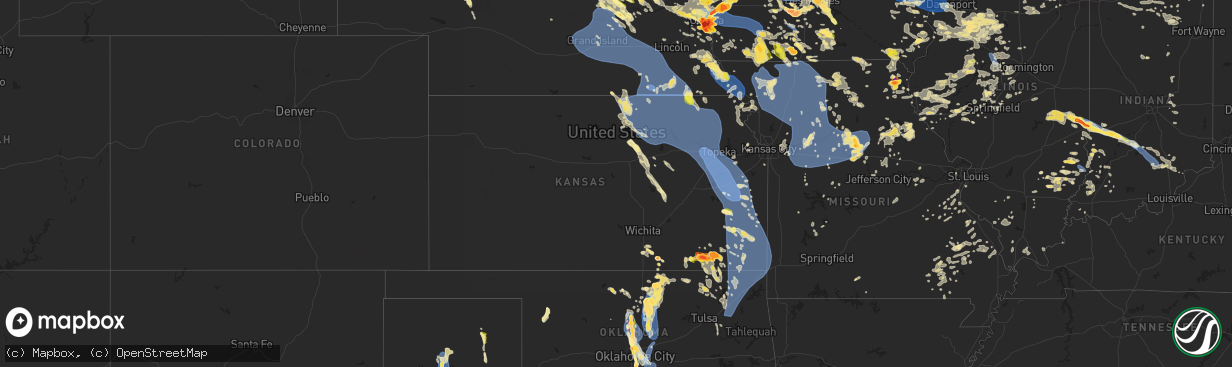
Hail Map in Kansas on June 25, 2024
The weather event in Kansas on June 25, 2024 includes Wind, Hail, and Tornado maps. 22 states and 2,131 cities were impacted and suffered possible damage. The total estimated number of properties impacted is 6,907.
Want more than just the map?
Turn this storm into a full workflow.
- Owner + property data so you know who to knock
- OnDemand branded weather history reports to win the "did we even have hail?" argument
- RoofTrace estimate so reps stop guessing numbers at the door
Bought this map? Upgrade within 7 days and we'll credit the $230. (10-15 min setup call)
Wind
Hail
Tornado
6,907
Estimated number of impacted properties by a 1.00" hail or larger672
Estimated number of impacted properties by a 1.75" hail or larger263
Estimated number of impacted properties by a 2.50" hail or largerStorm reports in Kansas
Kansas
| Date | Description |
|---|---|
| 06/25/20245:55 PM CDT | A local report indicates 1.25 inch wind near 3 SSW Winfield |
| 06/25/20245:39 PM CDT | Delayed report received via facebook. |
| 06/25/20245:46 AM CDT | Asos station kcfv coffeyville municipal airpt. |
| 06/25/20245:30 AM CDT | Dime size hail along with 70 mph winds. |
| 06/25/20245:21 AM CDT | Emergency manager reports 60 mph wind gusts and heavy rain near highway 7 and 126. |
| 06/25/20244:58 AM CDT | Asos station kcnu chanute martin johnson airpt. |
| 06/25/20244:50 AM CDT | Roof damage to home and tree damage to property. |
| 06/25/20244:38 AM CDT | Iola airport reported a 62 mph wind gust. |
| 06/25/20244:35 AM CDT | Large tree limb down in iola along with some electrical outages. |
| 06/25/20244:25 AM CDT | Delayed report. Emergency manager reported trees and branches down around paola including the town square. Time estimated via radar. |
| 06/25/20244:23 AM CDT | Downed power lines and power outages near 223rd street. Time estimated from radar. |
| 06/25/20244:23 AM CDT | Report from mping: 1-inch tree limbs broken; shingles blown off. |
| 06/25/20244:21 AM CDT | Downed power lines and power outages near flint drive. Time estimated from radar. |
| 06/25/20244:18 AM CDT | Six-inch diameter tree limb downed at a residence near 143rd and pflumm. Time estimated from radar. |
| 06/25/20244:15 AM CDT | Downed tree limbs and wires near antioch road. Time estimated from radar. |
| 06/25/20244:04 AM CDT | Downed tree and wires near 68th street. Time confirmed from radar and based on dispatch report. |
| 06/25/20244:02 AM CDT | Personal weather station. |
| 06/25/20244:00 AM CDT | Downed trees and downed tree branches. |
| 06/25/20243:56 AM CDT | Large limb of tree |
| 06/25/20243:56 AM CDT | Personal weather station. |
| 06/25/20243:52 AM CDT | Large branches snapped in the indian hills area of lawrence. Time estimated by radar. |
| 06/25/20243:45 AM CDT | Large portions of trees down between melvern and quenemo. |
| 06/25/20243:44 AM CDT | Personal weather station. |
| 06/25/20243:43 AM CDT | Report from mping: 3-inch tree limbs broken; power poles broken. |
| 06/25/20243:40 AM CDT | Via social media... 8 inch tree limb down... Damage to large cottonwood tree with various limbs down near 45th and gage blvd. Time estimated by radar. |
| 06/25/20243:39 AM CDT | Social media report of large tree branches down in vassar. Time estimated from radar. |
| 06/25/20243:35 AM CDT | Large tree snapped ion osage city. Time estimated from radar. |
| 06/25/20243:30 AM CDT | Report from mping: trees uprooted or snapped; roof blown off. Time adjusted via radar. |
| 06/25/20243:28 AM CDT | Large tree limbs down... Damage to trees. Via social media. Time estimated by radar. |
| 06/25/20243:27 AM CDT | Social media report for multiple uprooted trees... And a large tree snapped at its base. Time estimated by radar. |
| 06/25/20243:26 AM CDT | Public reports tree damage... Power lines down... As well as some structural damage to sheds and carports. |
| 06/25/20243:26 AM CDT | Power line reported down just east of wanamaker rd and 29th street. Time estimated by radar. |
| 06/25/20243:25 AM CDT | 12 inch diameter tree limb down. |
| 06/25/20243:25 AM CDT | 13 inch diameter tree branch down... Fence blown over. |
| 06/25/20243:25 AM CDT | Large diameter tree branch around 24 inches in diameter down in central topeka. Via social media. Time estimated by radar. |
| 06/25/20243:25 AM CDT | Lost power as well. |
| 06/25/20243:25 AM CDT | Corrects previous tstm wnd gst report from 7 wnw pauline. Lost power as well. |
| 06/25/20243:24 AM CDT | Lots of tree damage and power is out. |
| 06/25/20243:23 AM CDT | Report from mping: 1-inch tree limbs broken; shingles blown off. |
| 06/25/20243:23 AM CDT | Corrects previous tstm wnd dmg report from 7 w topeka. Report from mping: 1-inch tree limbs broken; shingles blown off. |
| 06/25/20243:22 AM CDT | Personal weather station. |
| 06/25/20243:22 AM CDT | Corrects previous tstm wnd gst report from 7 wsw topeka. |
| 06/25/20243:22 AM CDT | A local report indicates 65 MPH wind near 7 WSW Topeka |
| 06/25/20243:21 AM CDT | A local report indicates 70 MPH wind near 2 SE Willard |
| 06/25/20243:20 AM CDT | Multiple public reports of significant tree damage in silver lake. Time estimated from radar. |
| 06/25/20243:20 AM CDT | Tree damage across much of the community of silver lake consistent with widespread estimated 70-90 mph wind speeds. |
| 06/25/20243:16 AM CDT | Kstate mesonet. |
| 06/25/20243:15 AM CDT | *** 2 inj *** khp reports a semi was blown off of i-70 due to high winds. Two occupants in the semi were treated for minor injuries. |
| 06/25/20243:13 AM CDT | Large tree limbs broken... Peach tree uprooted. |
| 06/25/20243:12 AM CDT | Personal weather station. |
| 06/25/20243:10 AM CDT | Many trees down around willard. 13-16 inch diameter limbs down as well. Time estimated by radar. |
| 06/25/20243:08 AM CDT | 12 inch diameter tree snapped in maple hill. Time estimated from radar. |
| 06/25/20243:01 AM CDT | Personal weather station. |
| 06/25/20242:59 AM CDT | Small shed lost its roof and was knocked over in wamego. Time estimated from radar. |
| 06/25/20242:59 AM CDT | Personal weather station. |
| 06/25/20242:58 AM CDT | Personal weather station. |
| 06/25/20242:58 AM CDT | Personal weather station. |
| 06/25/20242:55 AM CDT | Social media report shows an 8 inch tree limb down on a home in manhattan. |
| 06/25/20242:55 AM CDT | Personal weather station. |
| 06/25/20242:55 AM CDT | Downed tree limbs and wires near state line road and 23rd street. Time estimated from radar. |
| 06/25/20242:53 AM CDT | Personal weather station. |
| 06/25/20242:52 AM CDT | Large tree snapped at the base. |
| 06/25/20242:50 AM CDT | Personal weather station. |
| 06/25/20242:45 AM CDT | Large tree 2 to 3 feet in diameter downed. Time estimated from radar. |
| 06/25/20242:43 AM CDT | Wooden frame of a 40 by 80 foot building blown over... With one wall remaining. |
| 06/25/20242:40 AM CDT | Union pacific mesonet. |
| 06/25/20242:37 AM CDT | Report from mping: 3-inch tree limbs broken; power poles broken. |
| 06/25/20242:37 AM CDT | Downed tree and wires near 13th terrace. Time based on dispatch report and confirmed from radar. |
| 06/25/20242:36 AM CDT | Clay center awos. |
| 06/25/20242:31 AM CDT | Downed tree and wires near hubbard road. Time estimated from radar. |
| 06/25/20242:28 AM CDT | Kstate mesonet. |
| 06/25/20242:28 AM CDT | Tree damage and power lines down. Time estimated from radar. |
| 06/25/20242:27 AM CDT | Downed tree limbs and wires near hadley avenue. Time based on dispatch report and confirmed from radar. |
| 06/25/20242:23 AM CDT | Downed tree and wires near mill street. Time based on dispatch report and confirmed from radar. |
| 06/25/20242:17 AM CDT | Power lines and tree damage in marysville. Estimated 70 mph wind gust. Time estimated from radar. |
| 06/25/20242:15 AM CDT | Pine tree around 2 feet in diameter snapped at the base in home... Metal outbuilding took damage as well. |
| 06/25/20242:09 AM CDT | Personal weather station. |
| 06/25/20241:49 AM CDT | Kstate mesonet. |
| 06/24/20248:45 PM CDT | Reported via social media. |
| 06/24/20248:45 PM CDT | A local report indicates 1.00 inch wind near 3 S Elk City |
| 06/24/20248:44 PM CDT | Stones had been sitting in yard for a time... But measured 1.5 - 2 inches in diameter. |
| 06/24/20248:32 PM CDT | Reported via social media. |
All States Impacted by Hail Map on June 25, 2024
Cities Impacted by Hail Map on June 25, 2024
- Whitehall, MI
- Holton, MI
- Muskegon, MI
- Twin Lake, MI
- Montague, MI
- Newaygo, MI
- Fremont, MI
- Grant, MI
- Conklin, MI
- Fenwick, MI
- Rockford, MI
- Fruitport, MI
- Ravenna, MI
- Sparta, MI
- Kent City, MI
- Greenville, MI
- Casnovia, MI
- Sand Lake, MI
- Bailey, MI
- Cedar Springs, MI
- Gowen, MI
- Lowell, MI
- Wayland, MI
- Saugatuck, MI
- Nunica, MI
- Marne, MI
- Hopkins, MI
- Zeeland, MI
- Orleans, MI
- Fennville, MI
- Allendale, MI
- Grandville, MI
- Jenison, MI
- West Olive, MI
- Wyoming, MI
- Caledonia, MI
- Spring Lake, MI
- Dorr, MI
- Byron Center, MI
- Holland, MI
- Allegan, MI
- Belmont, MI
- Grand Rapids, MI
- Comstock Park, MI
- Grand Haven, MI
- Coopersville, MI
- Macatawa, MI
- Belding, MI
- Hudsonville, MI
- Hamilton, MI
- Ada, MI
- Saranac, MI
- Freeport, MI
- Alto, MI
- Ionia, MI
- Lake Odessa, MI
- Middleville, MI
- Portland, MI
- Clarksville, MI
- Hastings, MI
- Shelbyville, MI
- Thomson, IL
- Mount Carroll, IL
- West Branch, IA
- Tipton, IA
- Monroe Center, IL
- Davis Junction, IL
- Kewanee, IL
- Annawan, IL
- Sheffield, IL
- Earlville, IL
- Sterling, IL
- Atalissa, IA
- Chadwick, IL
- Lanark, IL
- Cambridge, IL
- Atkinson, IL
- Geneseo, IL
- Oregon, IL
- Leaf River, IL
- Stillman Valley, IL
- Lindenwood, IL
- Kirkland, IL
- Esmond, IL
- Athens, MI
- Union City, MI
- East Leroy, MI
- Marcellus, MI
- Decatur, MI
- Schoolcraft, MI
- Lawton, MI
- Riverside, IA
- North Aurora, IL
- Aurora, IL
- Watervliet, MI
- Kalona, IA
- Wellman, IA
- Bangor, MI
- Covert, MI
- Milledgeville, IL
- Mchenry, IL
- Polo, IL
- Mount Morris, IL
- Forreston, IL
- Buda, IL
- Kingston, IL
- Chicago, IL
- Lone Tree, IA
- Woodstock, IL
- Galva, IL
- Jackson, MI
- West Liberty, IA
- Grass Lake, MI
- Bennett, IA
- Union, IL
- Marengo, IL
- Huntley, IL
- Wonder Lake, IL
- Dixon, IL
- Neponset, IL
- Sherwood, MI
- Mineral, IL
- Wyanet, IL
- Murray, IA
- Sycamore, IL
- Clare, IL
- Byron, IL
- Plainfield, IL
- Naperville, IL
- Oswego, IL
- Yorkville, IL
- Coloma, MI
- Hartford, MI
- Leland, IL
- Sherrard, IL
- Bishop Hill, IL
- Eau Claire, MI
- Sodus, MI
- Genoa, IL
- Manchester, MI
- Crystal Lake, IL
- Chelsea, MI
- Clarklake, MI
- Brooklyn, MI
- Bradford, IL
- Altona, IL
- Tiskilwa, IL
- Toulon, IL
- Woodhull, IL
- Dowagiac, MI
- Berrien Center, MI
- Franklin Grove, IL
- La Grange, IL
- Amboy, IL
- La Moille, IL
- Sublette, IL
- West Brooklyn, IL
- Morrison, IL
- Cassopolis, MI
- Compton, IL
- Spring Grove, IL
- Iowa City, IA
- Bronson, MI
- Holcomb, IL
- Benton Harbor, MI
- Addison, MI
- Cement City, MI
- Burbank, IL
- Justice, IL
- Willow Springs, IL
- Vandalia, MI
- Rochelle, IL
- Niles, MI
- Berrien Springs, MI
- Island Lake, IL
- Antioch, IL
- Alexis, IL
- Lynn Center, IL
- Newark, IL
- Salem, WI
- Trevor, WI
- Wauconda, IL
- Round Lake, IL
- Cary, IL
- Grayslake, IL
- Barrington, IL
- Ashton, IL
- Thayer, IA
- Steward, IL
- Bolingbrook, IL
- Twin Lakes, WI
- Richmond, IL
- Orland, IN
- Howe, IN
- Jones, MI
- White Pigeon, MI
- Oneida, IL
- New Boston, IL
- Joy, IL
- Seaton, IL
- Edwardsburg, MI
- Evergreen Park, IL
- Keota, IA
- Aledo, IL
- Little York, IL
- Shorewood, IL
- Minooka, IL
- Union, MI
- Lagrange, IN
- La Fayette, IL
- Mendota, IL
- Bristol, IN
- Joliet, IL
- Galesburg, IL
- Rio, IL
- Lake Villa, IL
- West Chester, IA
- Washington, IA
- Angola, IN
- Buchanan, MI
- Henderson, IL
- Wataga, IL
- Orion, IL
- Walkerton, IN
- Gerlaw, IL
- Ottawa, IL
- Wolcottville, IN
- La Salle, IL
- Peru, IL
- Utica, IL
- Serena, IL
- Hudson, IN
- South Bend, IN
- North Liberty, IN
- Wauseon, OH
- Delta, OH
- Wyoming, IL
- Elkhart, IN
- Osceola, IN
- Granger, IN
- Mishawaka, IN
- Victoria, IL
- Goshen, IN
- Seneca, IL
- Wedron, IL
- Wakarusa, IN
- Marseilles, IL
- Speer, IL
- Middlebury, IN
- Alpha, IL
- Pleasant Lake, IN
- Lakeville, IN
- Bremen, IN
- Ligonier, IN
- Hamlet, IN
- Union Mills, IN
- Westville, IN
- Kingsford Heights, IN
- La Porte, IN
- Davis City, IA
- Williamsfield, IL
- Monmouth, IL
- North Henderson, IL
- Nappanee, IN
- New Paris, IN
- Leon, IA
- Lineville, IA
- Princeville, IL
- Oquawka, IL
- Knoxville, IL
- Syracuse, IN
- Millersburg, IN
- Grovertown, IN
- Plymouth, IN
- Laura, IL
- Leesburg, IN
- Milford, IN
- Cromwell, IN
- Etna Green, IN
- Warsaw, IN
- Dahinda, IL
- East Galesburg, IL
- Brimfield, IL
- Rochester, IN
- Culver, IN
- Pierceton, IN
- Winona Lake, IN
- Larwill, IN
- Columbia City, IN
- North Webster, IN
- Elmwood, IL
- Cainsville, MO
- El Paso, IL
- Roanoke, IL
- Benson, IL
- Mercer, MO
- Gilson, IL
- La Fontaine, IN
- Wabash, IN
- Pekin, IL
- Keosauqua, IA
- Deer Creek, IL
- Eureka, IL
- Washington, IL
- Morton, IL
- Walton, IN
- Galveston, IN
- Logansport, IN
- East Peoria, IL
- Metamora, IL
- South Pekin, IL
- Tremont, IL
- Green Valley, IL
- Peoria, IL
- Groveland, IL
- Creve Coeur, IL
- Peoria Heights, IL
- Wapakoneta, OH
- Bonaparte, IA
- Fairview, IL
- Canton, IL
- Ellisville, IL
- Smithfield, IL
- Anna, OH
- Jackson Center, OH
- Maplewood, OH
- Sidney, OH
- Camden, IN
- Delavan, IL
- Port Jefferson, OH
- Botkins, OH
- Quincy, OH
- De Graff, OH
- Topeka, IL
- Havana, IL
- Stanford, IL
- Minier, IL
- Cuba, IL
- Armington, IL
- Milton, IA
- Douds, IA
- Manito, IL
- Forest City, IL
- Bellefontaine, OH
- Lewistown, OH
- Huntsville, OH
- Table Grove, IL
- Adair, IL
- Summitville, IN
- Alexandria, IN
- Kahoka, MO
- Farmington, IA
- Mount Sterling, IA
- West Liberty, OH
- Hopedale, IL
- Lewistown, IL
- Vermont, IL
- Ipava, IL
- McLean, IL
- Easton, IL
- Mason City, IL
- Zanesfield, OH
- Urbana, OH
- San Jose, IL
- New Holland, IL
- Bryant, IL
- Pendleton, IN
- Emden, IL
- Atlanta, IL
- Rushville, IL
- Industry, IL
- Liverpool, IL
- Fortville, IN
- Greenfield, IN
- Macomb, IL
- Hartsburg, IL
- Plymouth, IL
- Littleton, IL
- Augusta, IL
- Kenney, IL
- Lincoln, IL
- Waterloo, IN
- Ashley, IN
- London, OH
- Maroa, IL
- Chestnut, IL
- Charlottesville, IN
- Camden, IL
- Huntsville, IL
- Mount Pulaski, IL
- Carthage, IN
- Morristown, IN
- Arlington, IN
- Downing, MO
- Argenta, IL
- Latham, IL
- Arcola, IL
- Cerro Gordo, IL
- Milmine, IL
- La Prairie, IL
- Arthur, IL
- Tuscola, IL
- Petersburg, IL
- Greenview, IL
- Golden, IL
- Humboldt, IL
- Shelbyville, IN
- Waldron, IN
- Manilla, IN
- Athens, IL
- Clinton, IL
- Charleston, IL
- Brocton, IL
- Sullivan, IL
- Hindsboro, IL
- Mattoon, IL
- Oakland, IL
- Oreana, IL
- Monticello, IL
- Bement, IL
- Cisco, IL
- Timewell, IL
- Tallula, IL
- Beason, IL
- Oakford, IL
- Newman, IL
- Glasford, IL
- Astoria, IL
- Browning, IL
- Mount Sterling, IL
- Saint David, IL
- Kansas, IL
- Paris, IL
- Chillicothe, OH
- Frederick, IL
- Ashmore, IL
- Redmon, IL
- Ashland, IL
- Martinsville, IL
- Dennison, IL
- West Terre Haute, IN
- Quincy, IL
- Marshall, IL
- Meredosia, IL
- Jacksonville, IL
- Maywood, MO
- Durham, MO
- Cantrall, IL
- Springfield, IL
- Chapin, IL
- La Grange, MO
- Ewing, MO
- Mendon, IL
- Terre Haute, IN
- Winchester, IL
- Bluffs, IL
- Clayton, IL
- Camp Point, IL
- Fowler, IL
- Greenup, IL
- Sherman, IL
- Concord, IL
- Arenzville, IL
- Brazil, IN
- Riley, IN
- Taylor, MO
- Staunton, IN
- Farmersburg, IN
- Cory, IN
- Pleasant Plains, IL
- Cordesville, SC
- Annapolis, IL
- Willow Hill, IL
- Oblong, IL
- Buffalo, IL
- Paloma, IL
- Coatsburg, IL
- Centerpoint, IN
- Clay City, IN
- Bowling Green, IN
- Coal City, IN
- West Liberty, IL
- North Vernon, IN
- Dundas, IL
- Seymour, IN
- Versailles, IL
- Stoy, IL
- Robinson, IL
- Sullivan, IN
- Liberty, IL
- Alexander, IL
- New Berlin, IL
- Shelburn, IN
- Freedom, IN
- Sumner, IL
- Patricksburg, IN
- Spencer, IN
- Poland, IN
- Carlisle, IN
- Merom, IN
- Claremont, IL
- Flat Rock, IL
- Olney, IL
- Xenia, IL
- Dugger, IN
- Linton, IN
- Noble, IL
- Dawson, IL
- Riverton, IL
- Commiskey, IN
- Barry, IL
- Pittsfield, IL
- Brownstown, IN
- Crothersville, IN
- Bloomington, IN
- Kinderhook, IL
- Oaktown, IN
- Lawrenceville, IL
- Palestine, IL
- New Canton, IL
- Flora, IL
- Rinard, IL
- Hull, IL
- Rochester, IL
- Bridgeport, IL
- Baylis, IL
- New London, MO
- Bowman, SC
- Plainville, IL
- Clay City, IL
- Cisne, IL
- Green Cove Springs, FL
- West Union, IL
- Mount Erie, IL
- New Salem, IL
- Griggsville, IL
- Chambersburg, IL
- Calhoun, IL
- Elnora, IN
- West Salem, IL
- Washington, IN
- Ellettsville, IN
- Solsberry, IN
- Montgomery, IN
- Plainville, IN
- Seligman, AZ
- Parkersburg, IL
- Vincennes, IN
- Monroe City, IN
- Wheatland, IN
- Nashville, IN
- Saint Francisville, IL
- Murrayville, IL
- Mount Carmel, IL
- Rockport, IL
- Bicknell, IN
- Edwardsport, IN
- Vermilion, IL
- Gosport, IN
- Norman, IN
- Heltonville, IN
- Medora, IN
- Freetown, IN
- Vallonia, IN
- Pleasant Hill, IL
- Columbus, IN
- Ava, MO
- Squires, MO
- Geff, IL
- O'Brien, FL
- Sims, IL
- Summerton, SC
- Hazleton, IN
- Decker, IN
- Zolfo Springs, FL
- Vale, SD
- Newell, SD
- Waverly, IL
- Young, AZ
- Campbellsburg, IN
- Franklin, IL
- Golden Gate, IL
- Fairfield, IL
- Nisland, SD
- Francisco, IN
- Patoka, IN
- Payson, AZ
- Loami, IL
- Sturgis, SD
- Chatham, IL
- Hackberry, AZ
- Princeton, IN
- Jasper, IN
- Velpen, IN
- Huntingburg, IN
- Johnsonville, IL
- Albion, IL
- Palmyra, IL
- Paris Crossing, IN
- Austin, IN
- Bluford, IL
- New Carlisle, IN
- Galien, MI
- Enning, SD
- Union Center, SD
- Miles, IA
- Sabula, IA
- Louisiana, MO
- Ellery, IL
- Newton, IA
- McAlpin, FL
- Lexington, IN
- Scottsburg, IN
- Deputy, IN
- Stoutsville, MO
- Live Oak, FL
- Center, MO
- New Underwood, SD
- Vandalia, MO
- Frankford, MO
- Show Low, AZ
- Slater, MO
- Armstrong, MO
- Glasgow, MO
- Salisbury, MO
- Howes, SD
- Tallahassee, FL
- White Owl, SD
- Preston, IA
- Curryville, MO
- Perry, MO
- Fayette, MO
- Wasta, SD
- Santa Fe, MO
- Ridgeville, SC
- Gilliam, MO
- Walterboro, SC
- Amite, LA
- Greensburg, LA
- Higbee, MO
- Omaha, NE
- Council Bluffs, IA
- Shannon, IL
- Grinnell, IA
- Wall, SD
- Colfax, IA
- Summerville, SC
- Madison, MO
- Kellogg, IA
- Clinton, IA
- Fulton, IL
- Louisville, KY
- Sedona, AZ
- Saint Louis, MO
- Owanka, SD
- Box Elder, SD
- Bellevue, NE
- Garden Prairie, IL
- Harvard, IL
- Holliday, MO
- Paris, MO
- Monroe, IA
- Runnells, IA
- Mitchellville, IA
- Prairie City, IA
- Rocheport, MO
- Malcom, IA
- Marland, OK
- Gregory, SD
- Mexico, MO
- Harrisburg, MO
- Clark, MO
- Sturgeon, MO
- Ponca City, OK
- Coulterville, IL
- Mechanicsville, IA
- Winfield, KS
- Centralia, MO
- Laddonia, MO
- Thompson, MO
- Quinn, SD
- Philip, SD
- Ely, IA
- Bassett, NE
- Arkansas City, KS
- New Franklin, MO
- Kaw City, OK
- Belle, MO
- Offutt Afb, NE
- Fernley, NV
- Silver Springs, NV
- Farber, MO
- Plainview, NE
- Neligh, NE
- Lisbon, IA
- Boonville, MO
- Meadow Grove, NE
- Brooklyn, IA
- Pierce, NE
- Ewing, NE
- Inman, NE
- Stuart, NE
- Atkinson, NE
- Amelia, NE
- La Vista, NE
- Papillion, NE
- Pacific Junction, IA
- Franklin, MO
- Potosi, MO
- Belvidere, IL
- Wellington, KS
- Bryant, IA
- Glenwood, IA
- Rapid City, SD
- Tilden, NE
- Battle Creek, NE
- Delmar, IA
- Maquoketa, IA
- Newkirk, OK
- Burwell, NE
- Belle Plaine, KS
- Rimrock, AZ
- Auxvasse, MO
- Imperial, MO
- Barnhart, MO
- Mulvane, KS
- Udall, KS
- Hermosa, SD
- Caputa, SD
- Clearwater, NE
- Hartford, IA
- Swan, IA
- Carlisle, IA
- Pleasantville, IA
- Ackworth, IA
- Miami, TX
- Clarence, IA
- Charlotte, IA
- Hillsboro, MO
- Mount Vernon, IL
- Ralston, OK
- Shidler, OK
- Burbank, OK
- New Haven, MO
- Stockport, IA
- Hampshire, IL
- Warrenton, MO
- Goose Lake, IA
- Scenic, SD
- Kyle, SD
- Columbia, IL
- Kingdom City, MO
- Fulton, MO
- Palmyra, MO
- Valentine, NE
- Crescent, IA
- Seneca, NE
- Kadoka, SD
- Interior, SD
- Wanblee, SD
- Lewistown, MO
- Mullen, NE
- Pleasant Hill, IA
- Des Moines, IA
- Corydon, KY
- Henderson, KY
- Plattsmouth, NE
- Panhandle, TX
- Amarillo, TX
- Portales, NM
- Carter Lake, IA
- Norfolk, NE
- Norwalk, IA
- Altoona, IA
- Red Rock, OK
- Pawnee, OK
- Berger, MO
- Hermann, MO
- Cumming, IA
- Mclean, NE
- Osmond, NE
- De Soto, MO
- Orange City, FL
- Stanwood, IA
- Indianola, IA
- Oxford, KS
- Leslie, MO
- Blackwell, MO
- Fletcher, MO
- Solon, IA
- Allen, SD
- Mount Vernon, IA
- Danville, IA
- Prole, IA
- Madison, NE
- North Liberty, IA
- Festus, MO
- Owensville, MO
- Marathon, TX
- Randolph, NE
- Coleridge, NE
- La Belle, MO
- Knox City, MO
- Honey Creek, IA
- Underwood, IA
- Coralville, IA
- Debary, FL
- Neola, IA
- Martin, SD
- Magnet, NE
- Hartington, NE
- New London, IA
- Chariton, IA
- Lacona, IA
- Knoxville, IA
- De Witt, IA
- Williamstown, MO
- Monticello, MO
- Perry, OK
- Pawhuska, OK
- Russell, IA
- New Windsor, IL
- Tiffin, IA
- Lucas, IA
- Oxford, IA
- Pevely, MO
- Hills, IA
- Van Meter, IA
- Belle Rive, IL
- Viola, IL
- Bloomfield, NE
- Billings, OK
- Minden, IA
- Persia, IA
- Shelby, IA
- Avoca, IA
- Melcher Dallas, IA
- Columbia, IA
- Wyaconda, MO
- Morrison, OK
- Canton, MO
- Springfield, NE
- Owensboro, KY
- West Burlington, IA
- Yarmouth, IA
- Burlington, IA
- Sperry, IA
- Johnstown, NE
- Nichols, IA
- Sebree, KY
- Robards, KY
- Luray, MO
- Genoa City, WI
- San Manuel, AZ
- French Village, MO
- Tuthill, SD
- Merriman, NE
- Cody, NE
- Claude, TX
- Canyon, TX
- Stanton, NE
- Clarkson, NE
- Creston, NE
- Leigh, NE
- Long Valley, SD
- Causey, NM
- Calhoun, KY
- Saint Patrick, MO
- Blackwell, OK
- Slaughters, KY
- Dixon, KY
- Sparland, IL
- Farmington, MO
- Sainte Genevieve, MO
- South Amana, IA
- Homestead, IA
- Marengo, IA
- Sparks, NV
- Mineral Point, MO
- Putnam, IL
- Henry, IL
- Madisonville, KY
- Nebo, KY
- Van Buren, MO
- Ellington, MO
- Irondale, MO
- Lindsay, NE
- Saint Edward, NE
- Humphrey, NE
- Monroe, NE
- Wausa, NE
- Creighton, NE
- Norris, SD
- Page, NE
- Orchard, NE
- Orlando, OK
- Stillwater, OK
- Laurel, NE
- Newcastle, NE
- Ponca, NE
- Muscatine, IA
- Wilton, IA
- Durant, IA
- Moscow, IA
- Illinois City, IL
- Stockton, IA
- Walcott, IA
- Davenport, IA
- Blue Grass, IA
- Reynolds, IL
- Andalusia, IL
- Buffalo, IA
- Montpelier, IA
- Taylor Ridge, IL
- Milan, IL
- Rock Island, IL
- Missouri Valley, IA
- Bettendorf, IA
- Logan, IA
- Janesville, WI
- Brodhead, WI
- Sedan, KS
- Bonne Terre, MO
- Park Hills, MO
- Winner, SD
- Corydon, IA
- Manitou, KY
- Pampa, TX
- Vienna, MO
- Cedar Vale, KS
- Tonkawa, OK
- Keithsburg, IL
- Derby, IA
- Melrose, IA
- Bloomsdale, MO
- Harlan, IA
- Schuyler, NE
- Evansville, WI
- Crofton, NE
- Whitman, NE
- Milton, WI
- Avalon, WI
- Whitewater, WI
- Darien, WI
- Winnetoon, NE
- Platte Center, NE
- Winfield, IA
- Olds, IA
- Crawfordsville, IA
- Mount Pleasant, IA
- Osco, IL
- Wood, SD
- Ladora, IA
- Lovington, NM
- Parmelee, SD
- White River, SD
- Adel, IA
- Earlham, IA
- Winterset, IA
- Montezuma, IA
- West Des Moines, IA
- Saint Charles, IA
- Bevington, IA
- Truro, IA
- Williamsburg, IA
- Rogers, NM
- Cadet, MO
- New Virginia, IA
- Kirkwood, IL
- Hanson, KY
- Edelstein, IL
- Chillicothe, IL
- Coal Valley, IL
- Footville, WI
- Cantril, IA
- Nashville, IL
- Patterson, IA
- Woodbine, IA
- Portsmouth, IA
- Kirkman, IA
- Irwin, IA
- Grand River, IA
- Van Wert, IA
- Mulhall, OK
- Perkins, OK
- Coyle, OK
- Elk City, KS
- Modale, IA
- Saint Francis, SD
- Orfordville, WI
- Lowpoint, IL
- Peru, IA
- Lorimor, IA
- Fort Calhoun, NE
- Blair, NE
- Galena, IL
- Scales Mound, IL
- Elizabeth, IL
- Panama, IA
- Ophiem, IL
- Ashley, IL
- Du Bois, IL
- Yates City, IL
- Vichy, MO
- Menlo, IA
- Greenfield, IA
- Kimballton, IA
- Audubon, IA
- Manning, IA
- Fordyce, NE
- Hoskins, NE
- Verdigre, NE
- Havana, KS
- Independence, KS
- Covington, OK
- Cameron, IL
- Magnolia, IA
- Farmington, IL
- Hancock, IA
- Washburn, IL
- Maquon, IL
- Royal, NE
- Richwoods, MO
- Swisher, IA
- Mediapolis, IA
- Piedmont, MO
- Mill Spring, MO
- Middletown, IA
- Patterson, MO
- Garber, OK
- Mission, SD
- Mount Union, IA
- Tryon, OK
- Meridian, OK
- Wellston, OK
- Guthrie, OK
- Happy, TX
- Tulia, TX
- Pond Creek, OK
- Arbela, MO
- Fleming Island, FL
- Jacksonville, FL
- Westphalia, IA
- Earling, IA
- Sharon, OK
- Kilgore, NE
- McClelland, IA
- De Soto, IA
- Marshall, OK
- Douglas, OK
- Lucien, OK
- Saint Mary, MO
- Stuart, IA
- Guthrie Center, IA
- Panora, IA
- Winside, NE
- Wynot, NE
- Saint Helena, NE
- Luther, OK
- Carney, OK
- Dunlap, IA
- Hunter, OK
- Gordon, NE
- London Mills, IL
- Conesville, IA
- Longton, KS
- Hennessey, OK
- Denison, IA
- Ainsworth, IA
- Columbus Junction, IA
- Bourbon, MO
- Mapleton, IL
- Hanna City, IL
- Hamlin, IA
- Coon Rapids, IA
- Adair, IA
- Bison, OK
- Crescent, OK
- Kingfisher, OK
- Cashion, OK
- Tryon, NE
- Little Sioux, IA
- Onawa, IA
- Pisgah, IA
- Soldier, IA
- Moorhead, IA
- Cottageville, SC
- Salem, IA
- Manilla, IA
- Afton, IA
- Wayne, NE
- Pilger, NE
- Pinckneyville, IL
- Dixon, NE
- Letts, IA
- Osceola, IA
- Mondamin, IA
- Tekamah, NE
- Bennington, NE
- Dow City, IA
- Ute, IA
- Rogers, NE
- Dodge, NE
- Howells, NE
- Valley, NE
- Elkhorn, NE
- Waterloo, NE
- Linden, IA
- Redfield, IA
- Moulton, IA
- Coatsville, MO
- Bloomfield, IA
- Dexter, IA
- Ellston, IA
- Nash, OK
- West Point, IA
- Wooldridge, MO
- Jamestown, MO
- Cherryvale, KS
- Columbia, MO
- Arlington, NE
- Kennard, NE
- Arnett, OK
- Cedar Bluffs, NE
- Morse Bluff, NE
- North Bend, NE
- Lancaster, MO
- Charter Oak, IA
- Piedmont, OK
- Edmond, OK
- Arcadia, OK
- Oakland, IA
- Treynor, IA
- Macedonia, IA
- Silver City, IA
- Carson, IA
- Sutherland, NE
- Vail, IA
- Westside, IA
- Casey, IA
- Enid, OK
- Niobrara, NE
- Shannon City, IA
- Thedford, NE
- Creston, IA
- Wapello, IA
- Fontanelle, IA
- Queen City, MO
- Kiron, IA
- Deloit, IA
- Diagonal, IA
- Kilbourne, IL
- Weldon, IA
- Decatur, IA
- Gerald, MO
- Lenox, IA
- Dimmitt, TX
- Springfield, SD
- Newport, NE
- Orient, IA
- Hereford, TX
- Minburn, IA
- Dallas Center, IA
- Waukee, IA
- Oklahoma City, OK
- Bethany, OK
- Yukon, OK
- Choctaw, OK
- Jones, OK
- Spencer, OK
- Albion, NE
- Newman Grove, NE
- Emerson, IA
- Red Oak, IA
- Griswold, IA
- Elliott, IA
- Henderson, IA
- Lewis, IA
- Cumberland, IA
- Atlantic, IA
- Villisca, IA
- Grant, IA
- New Bloomfield, MO
- Prescott, IA
- Macksburg, IA
- Elgin, NE
- Nazareth, TX
- Corning, IA
- Donnellson, IA
- Bisbee, AZ
- Hillsboro, IA
- Martensdale, IA
- Washington, NE
- Hartsburg, MO
- Purdum, NE
- Williamson, IA
- Milo, IA
- Montgomery City, MO
- Williamsburg, MO
- Norman, OK
- Columbus, NE
- Center, NE
- Mount Ayr, IA
- Kellerton, IA
- Murphysboro, IL
- Ava, IL
- Ellsinore, MO
- Morning Sun, IA
- Tingley, IA
- Newark, MO
- Genoa, NE
- Carbon, IA
- Massena, IA
- Nodaway, IA
- Bridgewater, IA
- Urbandale, IA
- Clive, IA
- Grimes, IA
- Harrah, OK
- Mcloud, OK
- Newalla, OK
- Hart, TX
- Clearfield, IA
- Jefferson City, MO
- Lamoni, IA
- Alexandria, MO
- Ames, NE
- Ashland, MO
- Fredericktown, MO
- Fremont, NE
- Gravity, IA
- Yutan, NE
- Colon, NE
- Bethel, MO
- Benton, IA
- Blockton, IA
- Des Arc, MO
- Annapolis, MO
- New Market, IA
- Bedford, IA
- Sharpsburg, IA
- Boys Town, NE
- Shawnee, OK
- Tecumseh, OK
- Noble, OK
- Wanette, OK
- Macomb, OK
- Lexington, OK
- Clarinda, IA
- Avon, SD
- Millerton, IA
- Shambaugh, IA
- Lovilia, IA
- Plano, IA
- Promise City, IA
- Marquand, MO
- Schleswig, IA
- Evansville, IN
- Nebraska City, NE
- Oneill, NE
- Chambers, NE
- Talmage, NE
- Nickerson, NE
- Cedar Rapids, NE
- Redding, IA
- Brock, NE
- Herman, NE
- Sheridan, MO
- Hopkins, MO
- Salem, KY
- Marion, KY
- Julian, NE
- Peru, NE
- Humeston, IA
- Fullerton, NE
- Hagarville, AR
- Lamar, AR
- Hershey, NE
- Hatfield, MO
- Patton, MO
- Garden Grove, IA
- Perryville, MO
- Belgrade, NE
- Malvern, IA
- Cape Girardeau, MO
- Chaffee, MO
- Ord, NE
- Elyria, NE
- Silver Creek, NE
- Osceola, NE
- Clarks, NE
- Wolbach, NE
- Auburn, NE
- Brownville, NE
- Stanberry, MO
- Primrose, NE
- Shelbina, MO
- Grant City, MO
- Fairfax, MO
- Rock Port, MO
- Denver, MO
- Worth, MO
- Pickering, MO
- Parnell, MO
- Maryville, MO
- Ravenwood, MO
- Barnard, MO
- Gentry, MO
- Conception Junction, MO
- Skidmore, MO
- Graham, MO
- Bolckow, MO
- Conception, MO
- Clyde, MO
- Guilford, MO
- Martinsville, MO
- Darlington, MO
- Rea, MO
- New Hampton, MO
- McFall, MO
- Rosendale, MO
- Albany, MO
- Bethany, MO
- King City, MO
- Eagleville, MO
- Ridgeway, MO
- Blythedale, MO
- Princeton, MO
- Savannah, MO
- Union Star, MO
- Dunbar, NE
- Milan, MO
- Pollock, MO
- Kremlin, OK
- Green City, MO
- Lorton, NE
- Randolph, IA
- Unionville, MO
- Farragut, IA
- Glenwood, MO
- Payson, IL
- Nemaha, NE
- Kirksville, MO
- Brashear, MO
- Amity, MO
- Maysville, MO
- Central City, NE
- Essex, IA
- Shenandoah, IA
- Greenville, MO
- Imogene, IA
- Avoca, NE
- Riverton, IA
- Sidney, IA
- Wadesville, IN
- Craig, MO
- Oakdale, NE
- Falls City, NE
- Shubert, NE
- Verdon, NE
- Stella, NE
- Stromsburg, NE
- Polk, NE
- Hordville, NE
- Ashland, NE
- Petersburg, NE
- Otoe, NE
- Saint Paul, NE
- Palmer, NE
- Archer, NE
- Chapman, NE
- Boelus, NE
- Saint Libory, NE
- Dannebrog, NE
- Cairo, NE
- Rockville, NE
- Marquette, NE
- Wood River, NE
- Gibbon, NE
- Grand Island, NE
- Shelton, NE
- Ravenna, NE
- Phillips, NE
- Alda, NE
- Kenesaw, NE
- Juniata, NE
- Aurora, NE
- Hastings, NE
- Doniphan, NE
- Trumbull, NE
- Giltner, NE
- Maitland, MO
- Oregon, MO
- White Cloud, KS
- Forest City, MO
- Mound City, MO
- Rulo, NE
- Coffey, MO
- Gilman City, MO
- Humphreys, MO
- Jamesport, MO
- Galt, MO
- Pattonsburg, MO
- Spickard, MO
- Jameson, MO
- Trenton, MO
- Harris, MO
- Laredo, MO
- Altamont, MO
- Helena, MO
- Gallatin, MO
- Browning, MO
- Easton, MO
- Clarksdale, MO
- Weatherby, MO
- Cameron, MO
- Saint Joseph, MO
- Winston, MO
- Osborn, MO
- Stewartsville, MO
- Cosby, MO
- Ewing, IL
- Macedonia, IL
- Breckenridge, MO
- Hamilton, MO
- Chula, MO
- Chillicothe, MO
- Lock Springs, MO
- Kidder, MO
- Wheeling, MO
- Garland, NE
- Malcolm, NE
- Pleasant Dale, NE
- Benedict, NE
- Grandin, MO
- Greenwood, NE
- Neodesha, KS
- Valles Mines, MO
- Syracuse, NE
- Palmyra, NE
- Unadilla, NE
- Taylor, NE
- Lincoln, NE
- Saronville, NE
- Bradshaw, NE
- Clay Center, NE
- Hampton, NE
- Sutton, NE
- Harvard, NE
- York, NE
- Inland, NE
- Henderson, NE
- Louisville, NE
- Almo, KY
- Benton, KY
- Hardin, KY
- Dexter, KY
- South Bend, NE
- Murray, NE
- Nehawka, NE
- Memphis, MO
- Gretna, NE
- Naylor, MO
- Success, AR
- Vergennes, IL
- Templeton, IA
- Saint Paul, IA
- Liberty, KS
- Waverly, NE
- Moline, IL
- Amazonia, MO
- Seward, NE
- Milford, NE
- Cordova, NE
- Beaver Crossing, NE
- Exeter, NE
- McCool Junction, NE
- Waco, NE
- Utica, NE
- Friend, NE
- Fairmont, NE
- Dorchester, NE
- Grafton, NE
- Geneva, NE
- Tobias, NE
- Milligan, NE
- Ohiowa, NE
- Linneus, MO
- Meadville, MO
- Mooresville, MO
- Utica, MO
- Plattsburg, MO
- Braymer, MO
- Dawn, MO
- Turney, MO
- Cowgill, MO
- Lawson, MO
- Ludlow, MO
- Kingston, MO
- Polo, MO
- Lathrop, MO
- Wagner, SD
- Whitewater, MO
- Marble Hill, MO
- Burfordville, MO
- Highland, KS
- Troy, KS
- Palmersville, TN
- Fulton, KY
- Sedalia, KY
- Dukedom, TN
- De Soto, IL
- Brunswick, NE
- Vermillion, SD
- Murray, KY
- Green Castle, MO
- Wathena, KS
- Sedgewickville, MO
- Cedar Creek, NE
- Sterling, NE
- Cook, NE
- Robinson, KS
- Doniphan, MO
- Superior, NE
- Daykin, NE
- Byron, NE
- Deshler, NE
- Jackson, MO
- Lost Nation, IA
- Oak Ridge, MO
- Glenallen, MO
- Millersville, MO
- Alexandria, NE
- Chamois, MO
- Rayville, MO
- Hardin, MO
- Carrollton, MO
- Tina, MO
- Bogard, MO
- Norborne, MO
- Richmond, MO
- Hale, MO
- Bosworth, MO
- Odell, NE
- Crete, NE
- Clatonia, NE
- Cortland, NE
- Beatrice, NE
- Swanton, NE
- Virginia, NE
- Filley, NE
- Blue Springs, NE
- Wymore, NE
- Wilber, NE
- Hallam, NE
- De Witt, NE
- Plymouth, NE
- Pickrell, NE
- Western, NE
- Steele City, NE
- Diller, NE
- Jansen, NE
- Fairbury, NE
- Bremen, KS
- Hollenberg, KS
- Barnes, KS
- Hanover, KS
- Marysville, KS
- Greenleaf, KS
- Washington, KS
- Endicott, NE
- Hubbell, NE
- Gilead, NE
- Reynolds, NE
- Hebron, NE
- Narka, KS
- Scandia, KS
- Republic, KS
- Munden, KS
- Norway, KS
- Courtland, KS
- Belleville, KS
- Strang, NE
- Ethel, MO
- Elmer, MO
- Buchanan, TN
- New Concord, KY
- Maynard, AR
- Poplar Bluff, MO
- Williamsville, MO
- Denton, KS
- Mendon, MO
- Tecumseh, NE
- Chester, NE
- Warm Springs, AR
- Atchison, KS
- Jamestown, KS
- Pocahontas, AR
- Mahaska, KS
- Tamms, IL
- Ullin, IL
- Dongola, IL
- Keytesville, MO
- Anna, IL
- Higginsville, MO
- Malta Bend, MO
- Alma, MO
- Marshall, MO
- Dover, MO
- De Witt, MO
- Corder, MO
- Lexington, MO
- Waverly, MO
- Blackburn, MO
- Miami, MO
- Morrowville, KS
- Lewiston, NE
- Home, KS
- Beattie, KS
- Oketo, KS
- Barneston, NE
- Summerfield, KS
- Burchard, NE
- Pawnee City, NE
- Liberty, NE
- Axtell, KS
- Cuba, KS
- Haddam, KS
- Agenda, KS
- Morganville, KS
- Aurora, KS
- Linn, KS
- Blue Rapids, KS
- Concordia, KS
- Clyde, KS
- Clifton, KS
- Frankfort, KS
- Waterville, KS
- Palmer, KS
- Rockwood, IL
- Lodi, MO
- Clubb, MO
- Silva, MO
- Imboden, AR
- S Coffeyville, OK
- Arcadia, MO
- Baileyville, KS
- Erie, KS
- Chanute, KS
- Humboldt, KS
- Neosho Falls, KS
- Colony, KS
- Neelyville, MO
- Dover, TN
- Bevier, MO
- Beech Grove, AR
- Lenapah, OK
- Du Quoin, IL
- Elkville, IL
- Yorktown, IA
- Callao, MO
- Macon, MO
- Peach Orchard, AR
- Delaplaine, AR
- Onaga, KS
- Leonardville, KS
- Olsburg, KS
- Havensville, KS
- Westmoreland, KS
- Clay Center, KS
- Centralia, KS
- Vermillion, KS
- Randolph, KS
- Green, KS
- Corning, KS
- Miltonvale, KS
- Triplett, MO
- Huntsville, MO
- Dalton, MO
- Moberly, MO
- Clifton Hill, MO
- Brunswick, MO
- Nelson, MO
- Henrietta, MO
- Blackwater, MO
- Camden, MO
- Mayview, MO
- Concordia, MO
- Sweet Springs, MO
- Napoleon, MO
- Sibley, MO
- Oak Grove, MO
- Odessa, MO
- Orrick, MO
- Arrow Rock, MO
- Wellington, MO
- Bates City, MO
- Lone Jack, MO
- Houstonia, MO
- La Monte, MO
- Kingsville, MO
- Holden, MO
- Centerview, MO
- Knob Noster, MO
- Warrensburg, MO
- Pilot Grove, MO
- Hughesville, MO
- Sedalia, MO
- Sabetha, KS
- Wetmore, KS
- Seneca, KS
- Goff, KS
- Hooper, NE
- Du Bois, NE
- Mead, NE
- Coffeyville, KS
- Bern, KS
- New Boston, MO
- Biggers, AR
- Wann, OK
- Clearmont, MO
- Braddyville, IA
- Riley, KS
- Manhattan, KS
- Saint George, KS
- Wamego, KS
- Wakefield, KS
- Holton, KS
- Saint Marys, KS
- Soldier, KS
- Circleville, KS
- Belvue, KS
- Delia, KS
- Emmett, KS
- Iola, KS
- Rothville, MO
- Steelville, MO
- Cypress, IL
- Grand Chain, IL
- Vienna, IL
- Belknap, IL
- Karnak, IL
- Ironton, MO
- Whiting, KS
- Netawaka, KS
- Powhattan, KS
- Mayetta, KS
- Denison, KS
- Silver Lake, KS
- Topeka, KS
- Rossville, KS
- Maple Hill, KS
- Alma, KS
- Hoyt, KS
- Paxico, KS
- McFarland, KS
- Milford, KS
- Longford, KS
- Ogden, KS
- Eskridge, KS
- Harveyville, KS
- Auburn, KS
- Carbondale, KS
- Osawatomie, KS
- Wakarusa, KS
- Rantoul, KS
- Berryton, KS
- Ottawa, KS
- Overbrook, KS
- Pomona, KS
- Burlingame, KS
- Peru, KS
- Niotaze, KS
- Golconda, IL
- Independence, MO
- Buckner, MO
- Scranton, KS
- Quenemo, KS
- Vassar, KS
- Lyndon, KS
- Osage City, KS
- Tecumseh, KS
- Lawrence, KS
- Wellsville, KS
- Baldwin City, KS
- Reading, KS
- Allen, KS
- Jonesboro, AR
- Hampton, KY
- Smithland, KY
- Grain Valley, MO
- Galesburg, KS
- Richmond, KS
- Princeton, KS
- Halsey, NE
- Hanover, IN
- Blue Springs, MO
- La Plata, MO
- Novinger, MO
- Minneapolis, KS
- Solomon, KS
- Bennington, KS
- Kirksey, KY
- Piqua, KS
- Oxly, MO
- Claremore, OK
- Stilwell, KS
- Spalding, NE
- Clinton, MO
- Copan, OK
- Harrisburg, AR
- Weiner, AR
- Bay, AR
- Chelsea, OK
- Arnold, NE
- Winigan, MO
- Mayfield, KY
- Weeping Water, NE
- Garnett, KS
- Parsons, KS
- Centerville, KS
- Corning, AR
- Cole Camp, MO
- Mora, MO
- Chilhowee, MO
- Kincaid, KS
- Lane, KS
- Fillmore, MO
- Caney, KS
- Tyro, KS
- New Cambria, MO
- Winslow, IN
- Stover, MO
- Ansley, NE
- Mason City, NE
- Zalma, MO
- Lowndes, MO
- Wappapello, MO
- Lebo, KS
- Melvern, KS
- Waverly, KS
- Greeley, KS
- Williamsburg, KS
- Westphalia, KS
- Welda, KS
- Paola, KS
- Parker, KS
- Blue Mound, KS
- Burlington, KS
- Le Roy, KS
- Laclede, MO
- Brookfield, MO
- Gipsy, MO
- Atlanta, MO
- State University, AR
- Paragould, AR
- Dennis, KS
- Mound Valley, KS
- Warsaw, MO
- Uniontown, KS
- Bronson, KS
- Stark, KS
- Delaware, OK
- Barnsdall, OK
- Bartlesville, OK
- Humboldt, TN
- Elfrida, AZ
- Ochelata, OK
- Walnut, KS
- Elwood, KS
- Humansville, MO
- Collins, MO
- Pollard, AR
- Pittsburg, MO
- Edna, KS
- Ramona, OK
- Bolivar, MO
- Flemington, MO
- Gainesville, MO
- Girard, KS
- Petersburg, IN
- Salem, IN
- Hermitage, MO
- Thayer, KS
- Sumner, MO
- Bendena, KS
- Fair Play, MO
- Dunnegan, MO
- Glasco, KS
- Rosebud, MO
- Fort Scott, KS
- Redfield, KS
- Mapleton, KS
- Lancaster, KS
- Mound City, KS
- La Harpe, KS
- Moran, KS
- Arcadia, KS
- Farlington, KS
- Mulberry, KS
- Hepler, KS
- Mindenmines, MO
- Arma, KS
- Liberal, MO
- Savonburg, KS
- Elsmore, KS
- McCune, KS
- Frontenac, KS
- Saint Paul, KS
- Yates Center, KS
- Franklin, KS
- Pittsburg, KS
- Altamont, KS
- Oswego, KS
- Cherokee, KS
- Asbury, MO
- West Mineral, KS
- Scammon, KS
- Opolis, KS
- Weir, KS
- Columbus, KS
- Webb City, MO
- Oronogo, MO
- Galena, KS
- Carl Junction, MO
- Riverton, KS
- Quapaw, OK
- Baxter Springs, KS
- Miami, OK
- Bartlett, KS
- Joplin, MO
- Picher, OK
- Treece, KS
- Welch, OK
- Chetopa, KS
- Commerce, OK
- Delphos, KS
- Selmer, TN
- Stantonville, TN
- Cummings, KS
- Broken Arrow, OK
- Tonganoxie, KS
- Oneida, KS
- Abilene, KS
- Bonner Springs, KS
- Linwood, KS
- Ceresco, NE
- White City, KS
- North Miami, OK
- Bluejacket, OK
- Fairland, OK
- Seneca, MO
- Talala, OK
- Nowata, OK
- Gypsum, KS
- Tampa, KS
- Hope, KS
- Vinita, OK
- Elk Falls, KS
- Coweta, OK
- Manila, AR
- Marion, KS
- Lincolnville, KS
- Piggott, AR
- Fredonia, KS
- Trumann, AR
- Harviell, MO
- Brookland, AR
- Fairdealing, MO
- Ramona, KS
- Dewey, OK
- Ramer, TN
- Guys, TN
- Enville, TN
- Reagan, TN
- Florence, KS
- Hardy, NE
- Cedar Point, KS
- El Dorado Springs, MO
- Leachville, AR
- Bethel Springs, TN
- Adamsville, TN
- Big Cabin, OK
- Adair, OK
- Pryor, OK
- Chouteau, OK
- Inola, OK
- Afton, OK
- Rienzi, MS
- Webber, KS
- Tarkio, MO
- Lexington, TN
- Tabor, IA
- Haskell, OK
- Excelsior Springs, MO
- Enterprise, KS
- Chapman, KS
- Junction City, KS
- Hiawatha, KS
- Durham, KS
- Merrill, WI
- Deerbrook, WI
- Irma, WI
- Tomahawk, WI
- Gleason, WI
- Wausau, WI
- Mosinee, WI
- Athens, WI
- Antigo, WI
- Brokaw, WI
- Schofield, WI
- Rothschild, WI
- Aniwa, WI
- Marathon, WI
- Neopit, WI
- Wittenberg, WI
- Birnamwood, WI
- Rosholt, WI
- Eland, WI
- White Lake, WI
- Keshena, WI
- Mattoon, WI
- Bowler, WI
- Hatley, WI
- Bryant, WI
- Elton, WI
- Ringle, WI
- Edgar, WI
- Medford, WI
- Westboro, WI
- Ogema, WI
- Stetsonville, WI
- Rib Lake, WI
- Dorchester, WI
- Catawba, WI
- Prentice, WI
- Tripoli, WI
- Pound, WI
- Gresham, WI
- Suring, WI
- Iola, WI
- Stevens Point, WI
- Custer, WI
- Caroline, WI
- Amherst Junction, WI
- Tilleda, WI
- Shawano, WI
- Tigerton, WI
- Marion, WI
- Gillett, WI
- Leopolis, WI
- Clintonville, WI
- Nichols, WI
- Appleton, WI
- Forestville, WI
- Combined Locks, WI
- Sturgeon Bay, WI
- Seymour, WI
- Pulaski, WI
- Casco, WI
- Green Bay, WI
- Brillion, WI
- Little Suamico, WI
- Algoma, WI
- Cecil, WI
- Reedsville, WI
- Manawa, WI
- Greenleaf, WI
- Suamico, WI
- Green Valley, WI
- Hilbert, WI
- Shiocton, WI
- Little Chute, WI
- Oconto, WI
- Peshtigo, WI
- Oconto Falls, WI
- Bear Creek, WI
- Denmark, WI
- Hortonville, WI
- De Pere, WI
- Sobieski, WI
- New Franken, WI
- Sherwood, WI
- Menasha, WI
- Wrightstown, WI
- Forest Junction, WI
- Neenah, WI
- New London, WI
- Abrams, WI
- Luxemburg, WI
- Kaukauna, WI
- Black Creek, WI
- Brussels, WI
- Krakow, WI
- Oneida, WI
- Lena, WI
- Bonduel, WI
- Greenville, WI
- Embarrass, WI
- Chilton, WI
- Kimberly, WI
- Weyauwega, WI
- Scandinavia, WI
- Coleman, WI
- Ogdensburg, WI
- New Holstein, WI
- Maribel, WI
- Two Rivers, WI
- Elkhart Lake, WI
- Kiel, WI
- Mishicot, WI
- Whitelaw, WI
- Kewaunee, WI
- Potter, WI
- Valders, WI
- Manitowoc, WI
- Collins, WI
- Francis Creek, WI
- Sheboygan, WI
- Glenbeulah, WI
- Plymouth, WI
- Saint Nazianz, WI
- Sheboygan Falls, WI
- Newton, WI
- Oostburg, WI
- Waldo, WI
- Cedar Grove, WI
- Kohler, WI
- Cleveland, WI
- Oxford Junction, IA
- Douglas, AZ


