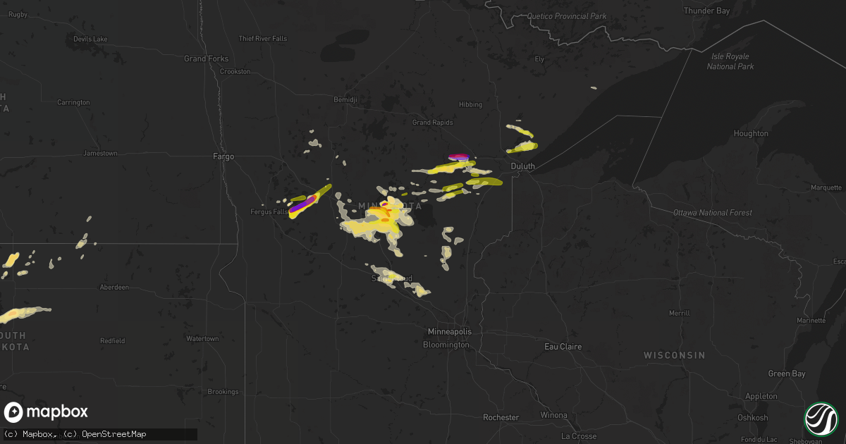
Hail Map in Minnesota on June 23, 2022
Get this storm
June 23 map
$229
one time, instant access
Download today. No call, no setup
Keep the $229
Bought the map and want the full workflow? Apply the entire $229 to a subscription within 7 days. None of it is wasted.
Every map, not just this one
This buys you this map. Subscription and you get every map we run, in the markets you choose from a few cities to whole states to nationwide. Plus real-time alerts the moment a storm fires.
Contact data
Name, contact info, occupancy, even credit band for addresses in the footprint. You go from where it hit to who to call.
Become the source they trust
Unlimited branding weather history reports on demand. You already have the documented answer ready for the property owner, and you are the one who showed up with it.
Property data and RoofTrace estimates
Pull up any address you have got, its value and the exact code rules for that jurisdiction, straight from One Click Code. Then RoofTrace estimates the squares, pitch, and roof value, priced the way you price.
Storm reports in Minnesota
Minnesota
| Date | Description |
|---|---|
| 06/23/20226:55 PM CDT | Report via social media with photo. |
| 06/23/20226:50 PM CDT | A local report indicates 1.00 inch wind near 1 SE CROSBY |
| 06/23/20226:46 PM CDT | Report from mping: quarter |
| 06/23/20226:45 PM CDT | Report via social media with photo. |
| 06/23/20226:40 PM CDT | Report via social media with ruler photo. |
| 06/23/20226:40 PM CDT | A local report indicates 1.00 inch wind near CROSBY |
| 06/23/20226:40 PM CDT | A local report indicates 1.75 inch wind near 1 SW BRAINERD |
| 06/23/20226:39 PM CDT | Report from mping: quarter |
| 06/23/20226:38 PM CDT | A local report indicates 1.00 inch wind near 1 S CROSBY |
| 06/23/20226:29 PM CDT | Report via social media with measurement picture. |
| 06/23/20226:27 PM CDT | A local report indicates 1.00 inch wind near 1 WNW BRAINERD |
| 06/23/20226:26 PM CDT | A local report indicates 1.00 inch wind near 2 SW BRAINERD |
| 06/23/20226:15 PM CDT | Two rounds of golf ball size hail... With the first round being about 15 minutes earlier than the time listed. Location approximate. Report received via facebook. |
| 06/23/20226:13 PM CDT | Report from mping: ping pong ball |
| 06/23/20226:10 PM CDT | Report via social media with photo. |
| 06/23/20226:10 PM CDT | A local report indicates 1.00 inch wind near 1 WNW BRAINERD |
| 06/23/20226:10 PM CDT | Report from mping: quarter |
| 06/23/20226:09 PM CDT | Report via social media with photo. |
| 06/23/20226:07 PM CDT | A local report indicates 1.75 inch wind near 2 NE BAXTER |
| 06/23/20225:21 PM CDT | A local report indicates 1.50 inch wind near 8 S MOTLEY |
| 06/23/20226:59 AM CDT | A local report indicates 2.75 inch wind near 6 S OTTERTAIL |
| 06/23/20226:50 AM CDT | A local report indicates 1.00 inch wind near 4 S NEW YORK MILLS |
| 06/23/20226:32 AM CDT | A local report indicates 2.50 inch wind near BATTLE LAKE |
| 06/23/20226:31 AM CDT | A local report indicates 1.00 inch wind near BATTLE LAKE |
| 06/23/20225:35 AM CDT | At 1035 PM CDT, a severe thunderstorm was located over Randall, or 11 miles northwest of Little Falls, moving southeast at 25 mph. HAZARD...60 mph wind gusts and half dollar size hail. SOURCE...Radar indicated. IMPACT...Hail damage to vehicles is expected. Expect wind damage to roofs, siding, and trees. This severe thunderstorm will be near... Camp Ripley around 1050 PM CDT. |
| 06/23/20225:08 AM CDT | At 1006 PM CDT, severe thunderstorms were located along a line extending from Quamba, to 7 miles east of Grantsburg, moving southeast at 25 mph. HAZARD...60 mph wind gusts and quarter size hail. SOURCE...Trained weather spotters reported funnel clouds near Grantsburg. IMPACT...Hail damage to vehicles is expected. Expect wind damage to roofs, siding, and trees. Severe thunderstorms will be near... Siren around 1025 PM CDT.Other locations in the path of these severe thunderstorms includePine City, Rock Creek and Grantsburg. |
| 06/23/20224:57 AM CDT | At 957 PM CDT, a severe thunderstorm was located near Knife River, or 22 miles northeast of Superior, moving east at 25 mph. HAZARD...60 mph wind gusts and half dollar size hail. SOURCE...Radar indicated. IMPACT...Hail damage to vehicles is expected. Expect wind damage to roofs, siding, and trees. This severe thunderstorm will be near... Stoney Point around 1000 PM CDT. Larsmont and Knife River around 1010 PM CDT.Other locations in the path of this severe thunderstorm include TwoHarbors and Castle Danger. |
| 06/23/20224:21 AM CDT | At 921 PM CDT, severe thunderstorms were located along a line extending from 8 miles west of Vineland, to near Fort Ripley, moving southeast at 15 mph. HAZARD...60 mph wind gusts and half dollar size hail. SOURCE...Radar indicated. IMPACT...Hail damage to vehicles is expected. Expect wind damage to roofs, siding, and trees. These severe thunderstorms will remain over mainly rural areas of southwestern Crow Wing County, including the following locations... Erskin Lake. |
| 06/23/20224:18 AM CDT | At 917 PM CDT, a severe thunderstorm was located 11 miles east of Boulder Lake, or 27 miles north of Superior, moving east at 15 mph. HAZARD...Quarter size hail. SOURCE...Radar indicated. IMPACT...Damage to vehicles is expected. Locations impacted include... Larsmont and Two Harbors. |
| 06/23/20224:14 AM CDT | At 914 PM CDT, a severe thunderstorm was located 6 miles southeast of Saint Mathias, or 13 miles northeast of Little Falls, moving east at 35 mph. HAZARD...60 mph wind gusts and half dollar size hail. SOURCE...Radar indicated. IMPACT...Hail damage to vehicles is expected. Expect wind damage to roofs, siding, and trees. This severe thunderstorm will be near... Lastrup around 930 PM CDT. |
| 06/23/20224:08 AM CDT | At 908 PM CDT, a severe thunderstorm was located near Pike Lake Near Duluth, or 15 miles northeast of Cloquet, moving east at 25 mph. HAZARD...60 mph wind gusts and half dollar size hail. SOURCE...Radar indicated. IMPACT...Hail damage to vehicles is expected. Expect wind damage to roofs, siding, and trees. This severe thunderstorm will be near... Hermantown around 925 PM CDT.Other locations in the path of this severe thunderstorm includeIsland Lake, City of Rice Lake, French River and Stoney Point. |
| 06/23/20223:44 AM CDT | At 844 PM CDT, a severe thunderstorm was located over Fort Ripley, or 14 miles north of Little Falls, moving east at 20 mph. HAZARD...Quarter size hail. SOURCE...Radar indicated. IMPACT...Damage to vehicles is expected. Locations impacted include... Saint Mathias. |
| 06/23/20223:43 AM CDT | At 843 PM CDT, a severe thunderstorm was located over Fort Ripley, or 13 miles north of Little Falls, moving east at 35 mph. HAZARD...60 mph wind gusts and half dollar size hail. SOURCE...Radar indicated. IMPACT...Hail damage to vehicles is expected. Expect wind damage to roofs, siding, and trees. This severe thunderstorm will remain over mainly rural areas of central Morrison County. |
| 06/23/20223:37 AM CDT | At 836 PM CDT, a severe thunderstorm was located 8 miles north of Boulder Lake, or 31 miles north of Superior, moving east at 20 mph. HAZARD...60 mph wind gusts and quarter size hail. SOURCE...Radar indicated. IMPACT...Hail damage to vehicles is expected. Expect wind damage to roofs, siding, and trees. This severe thunderstorm will remain over mainly rural areas of southeastern St. Louis County, including the following locations... Pequaywan Lake and Comstock Lake. |
| 06/23/20223:30 AM CDT | At 830 PM CDT, a severe thunderstorm was located 6 miles southwest of Vineland, or 14 miles southwest of Mille Lacs Lake, moving southeast at 15 mph. HAZARD...60 mph wind gusts and half dollar size hail. SOURCE...Radar indicated. IMPACT...Hail damage to vehicles is expected. Expect wind damage to roofs, siding, and trees. This severe thunderstorm will be near... Vineland around 845 PM CDT.Other locations in the path of this severe thunderstorm includeOnamia and Wahkon. |
| 06/23/20223:23 AM CDT | At 823 PM CDT, severe thunderstorms were located along a line extending from near Garrison, to near Vineland, to near Saint Mathias, moving southeast at 10 mph. HAZARD...60 mph wind gusts and half dollar size hail. SOURCE...Radar indicated. IMPACT...Hail damage to vehicles is expected. Expect wind damage to roofs, siding, and trees. Severe thunderstorms will be near... Garrison around 840 PM CDT.Other locations in the path of these severe thunderstorms includeMille Lacs Lake and Malmo. |
| 06/23/20223:10 AM CDT | At 809 PM CDT, a severe thunderstorm was located near Big Sandy Lake, moving east at 35 mph. HAZARD...60 mph wind gusts and quarter size hail. SOURCE...Radar indicated. IMPACT...Hail damage to vehicles is expected. Expect wind damage to roofs, siding, and trees. Locations impacted include... Floodwood and Fond Du Lac Band Brookston Area. |
| 06/23/20222:48 AM CDT | At 748 PM CDT, a severe thunderstorm was located near Cotton, or 31 miles southeast of Hibbing, moving east at 20 mph. HAZARD...Half dollar size hail. SOURCE...Radar indicated. IMPACT...Damage to vehicles is expected. Locations impacted include... Wolf Lake. |
| 06/23/20222:46 AM CDT | At 746 PM CDT, a severe thunderstorm was located near Baxter, or 7 miles southwest of Brainerd, moving east at 10 mph. HAZARD...Ping pong ball size hail and 60 mph wind gusts. SOURCE...Trained weather spotters. IMPACT...People and animals outdoors will be injured. Expect hail damage to roofs, siding, windows, and vehicles. Expect wind damage to roofs, siding, and trees. This severe thunderstorm will be near... Baxter around 800 PM CDT. Saint Mathias around 805 PM CDT.Other locations in the path of this severe thunderstorm includeBrainerd. |
| 06/23/20222:35 AM CDT | At 733 PM CDT, a severe thunderstorm was located 10 miles northwest of Hovland, or 19 miles northeast of Grand Marais, moving east at 30 mph. HAZARD...60 mph wind gusts and quarter size hail. SOURCE...Radar indicated. IMPACT...Hail damage to vehicles is expected. Expect wind damage to roofs, siding, and trees. This severe thunderstorm will be near... Hovland around 750 PM CDT.Other locations in the path of this severe thunderstorm include GrandPortage. |
| 06/23/20222:33 AM CDT | At 733 PM CDT, a severe thunderstorm was located near Upper South Long Lake, or 9 miles east of Brainerd, moving east at 15 mph. HAZARD...Golf ball size hail. SOURCE...Radar indicated. IMPACT...People and animals outdoors will be injured. Expect damage to roofs, siding, windows, and vehicles. Locations impacted include... Garrison. |
| 06/23/20222:32 AM CDT | At 732 PM CDT, severe thunderstorms were located along a line extending from 10 miles west of Palisade, to near Cuyuna, moving east at 20 mph. HAZARD...Quarter size hail. SOURCE...Radar indicated. IMPACT...Damage to vehicles is expected. Locations impacted include... Aitkin, Palisade, Big Sandy Lake and Libby. |
| 06/23/20222:30 AM CDT | A local report indicates 1.00 inch wind near WAITE PARK |
| 06/23/20222:21 AM CDT | At 721 PM CDT, a severe thunderstorm was located near Mille Lacs Band East Lake Area, or 20 miles south of Big Sandy Lake, moving east at 30 mph. HAZARD...Ping pong ball size hail. SOURCE...Radar indicated. IMPACT...People and animals outdoors will be injured. Expect damage to roofs, siding, windows, and vehicles. Locations impacted include... Kettle River. |
| 06/23/20222:16 AM CDT | At 716 PM CDT, a severe thunderstorm was located over Pillager, or 12 miles west of Brainerd, moving east at 20 mph. HAZARD...60 mph wind gusts and half dollar size hail. SOURCE...Radar indicated. IMPACT...Hail damage to vehicles is expected. Expect wind damage to roofs, siding, and trees. Locations impacted include... Baxter. |
| 06/23/20222:15 AM CDT | At 714 PM CDT, a severe thunderstorm was located over Pillager, or 11 miles west of Brainerd, moving east at 20 mph. HAZARD...Ping pong ball size hail and 60 mph wind gusts. SOURCE...Radar indicated. IMPACT...People and animals outdoors will be injured. Expect hail damage to roofs, siding, windows, and vehicles. Expect wind damage to roofs, siding, and trees. This severe thunderstorm will remain over mainly rural areas of northwestern Morrison County, including the following locations... Crow Wing State Park. |
| 06/23/20222:11 AM CDT | At 711 PM CDT, a severe thunderstorm was located near Aitkin, or 15 miles north of Mille Lacs Lake, moving east at 35 mph. HAZARD...60 mph wind gusts and quarter size hail. SOURCE...Radar indicated. IMPACT...Hail damage to vehicles is expected. Expect wind damage to roofs, siding, and trees. Locations impacted include... Mille Lacs Band East Lake Area, McGregor and Tamarack. |
| 06/23/20222:03 AM CDT | At 702 PM CDT, a severe thunderstorm was located 10 miles southeast of Babbitt, or 24 miles south of Ely, moving east at 25 mph. HAZARD...60 mph wind gusts and quarter size hail. SOURCE...Radar indicated. IMPACT...Hail damage to vehicles is expected. Expect wind damage to roofs, siding, and trees. Locations impacted include... Whyte, Isabella and Dumbbell Lake. |
| 06/23/20221:55 AM CDT | Report from mping: quarter |
| 06/23/20221:55 AM CDT | A local report indicates 1.00 inch wind near 1 W ST. CLOUD |
| 06/23/20221:55 AM CDT | Mping report. |
| 06/23/20221:47 AM CDT | At 646 PM CDT, a severe thunderstorm was located 9 miles northeast of Big Sandy Lake, moving east at 20 mph. HAZARD...Half dollar size hail. SOURCE...Radar indicated. IMPACT...Damage to vehicles is expected. Locations impacted include... Floodwood. |
| 06/23/20221:45 AM CDT | At 644 PM CDT, a severe thunderstorm was located 7 miles east of Gunflint Lake, moving east at 30 mph. HAZARD...60 mph wind gusts and half dollar size hail. SOURCE...Radar indicated. IMPACT...Hail damage to vehicles is expected. Expect wind damage to roofs, siding, and trees. Locations impacted include... Boundary Waters Canoe Area Wilderness North of the Gunflint Trail. |
| 06/23/20221:44 AM CDT | At 644 PM CDT, a severe thunderstorm was located near Saint Mathias, or near Brainerd, moving east at 15 mph. HAZARD...Golf ball size hail. SOURCE...Radar indicated. IMPACT...People and animals outdoors will be injured. Expect damage to roofs, siding, windows, and vehicles. This severe thunderstorm will be near... Brainerd around 700 PM CDT.Other locations in the path of this severe thunderstorm include SouthLong Lake, Upper South Long Lake and Garrison. |
| 06/23/20221:25 AM CDT | At 625 PM CDT, a severe thunderstorm was located over Garrison, or near Mille Lacs Lake, moving east at 40 mph. HAZARD...Quarter size hail. SOURCE...Radar indicated. IMPACT...Damage to vehicles is expected. This severe thunderstorm will be near... Mille Lacs Lake and Malmo around 645 PM CDT. |
| 06/23/20221:06 AM CDT | At 606 PM CDT, a severe thunderstorm was located near Gull Lake, or near Brainerd, moving east at 25 mph. HAZARD...Ping pong ball size hail and 60 mph wind gusts. SOURCE...Radar indicated. IMPACT...People and animals outdoors will be injured. Expect hail damage to roofs, siding, windows, and vehicles. Expect wind damage to roofs, siding, and trees. This severe thunderstorm will be near... Brainerd around 615 PM CDT. Merrifield around 620 PM CDT.Other locations in the path of this severe thunderstorm includeIronton, Crosby and Cuyuna. |
| 06/23/202212:59 AM CDT | At 559 PM CDT, a severe thunderstorm was located near Pillager, or 13 miles southwest of Brainerd, moving east at 25 mph. HAZARD...60 mph wind gusts and half dollar size hail. SOURCE...Radar indicated. IMPACT...Hail damage to vehicles is expected. Expect wind damage to roofs, siding, and trees. Locations impacted include... Saint Mathias, Baxter, Brainerd, South Long Lake and Upper South Long Lake. |
| 06/22/202210:21 PM CDT | Facebook picture of a large aspen down across road. Time and location approximated. |
| 06/22/202210:15 PM CDT | Reporter was not sure on the exact time and estimated 945 pm... But said the radar showed the storms to the north. There is a velocity signature that occurred near the |
| 06/22/20229:49 PM CDT | Report via social media with photo. |
| 06/22/20229:35 PM CDT | A local report indicates 1.00 inch wind near FORT RIPLEY |
| 06/22/20229:25 PM CDT | A local report indicates 1.50 inch wind near 3 SSW SAINT MATHIAS |
| 06/22/20229:22 PM CDT | Tree blown down crushing screen house. |
| 06/22/20229:16 PM CDT | A local report indicates 1.00 inch wind near 2 WSW FREDENBERG |
| 06/22/20229:07 PM CDT | A local report indicates 1.25 inch wind near FORT RIPLEY |
| 06/22/20229:05 PM CDT | A local report indicates 1.25 inch wind near 1 N FORT RIPLEY |
| 06/22/20228:45 PM CDT | A local report indicates 1.00 inch wind near 7 SE BRAINERD |
| 06/22/20228:42 PM CDT | Report via social media with picture. |
| 06/22/20228:27 PM CDT | Winds lofted a trampoline across the yard and over a pool. Time and location approximated from radar. |
| 06/22/20228:15 PM CDT | Report via social media with picture. |
| 06/22/20228:11 PM CDT | Report via social media with photo. |
| 06/22/20228:10 PM CDT | Report via social media with ruler photo. |
| 06/22/20228:07 PM CDT | Some quarter size hailstones with lots of smaller stones. |
| 06/22/20228:04 PM CDT | Report via social media with photo. |
| 06/22/20228:02 PM CDT | Report received via facebook. Pictures and video show hail sizes measured up to 2 inches in diameter. |
| 06/22/20228:00 PM CDT | Branches of various sizes broken. Swamp filled with water. Time approximated. 2.53 inches of rain. |
| 06/22/20227:55 PM CDT | Report via social media with photo. |
| 06/22/20227:55 PM CDT | Report 1 medium size tree snapped at base in backyard. |
| 06/22/20227:55 PM CDT | A local report indicates 1.00 inch wind near BAXTER |
| 06/22/20227:52 PM CDT | A local report indicates 1.00 inch wind near 1 SW BAXTER |
| 06/22/20227:50 PM CDT | Report via social media with photo. |
| 06/22/20227:50 PM CDT | A local report indicates 1.00 inch wind near LAWLER |
| 06/22/20227:40 PM CDT | Report via social media with photos of multiple medium to large trees snapped at base down over roads and power lines. Time estimated from report and radar. |
| 06/22/20227:36 PM CDT | A local report indicates 1.00 inch wind near 3 NW LAWLER |
| 06/22/20227:35 PM CDT | A local report indicates 1.75 inch wind near 4 E PILLAGER |
| 06/22/20227:35 PM CDT | A local report indicates 1.00 inch wind near 3 S AITKIN |
| 06/22/20227:35 PM CDT | Report via social media with photo. |
| 06/22/20227:25 PM CDT | Delayed report... Time estimated from radar. |
| 06/22/20227:20 PM CDT | Corrects previous tstm wnd dmg report from 7 ese brainerd. Large tree snapped roughly 5 feet up from base. Report with photo. |
| 06/22/20227:00 PM CDT | Report via social media with photo. |
All States Impacted by Hail Map on June 23, 2022
Cities Impacted by Hail Map on June 23, 2022
- Minot, ND
- Kettle River, MN
- Barnum, MN
- Sedona, AZ
- Clarissa, MN
- Browerville, MN
- New Town, ND
- Parshall, ND
- Oak Hill, FL
- Clarkdale, AZ
- Abbeville, LA
- Brainerd, MN
- Cotton, MN
- Makinen, MN
- Shell Knob, MO
- Lampe, MO
- Green Forest, AR
- Berryville, AR
- Sebeka, MN
- Gaylord, KS
- Aitkin, MN
- Bottineau, ND
- Malta, MT
- Ogilvie, MN
- Braham, MN
- Mora, MN
- Fergus Falls, MN
- Maricopa, AZ
- Norwich, ND
- Velva, ND
- Sawyer, ND
- Coushatta, LA
- Osborne, KS
- Duluth, MN
- Des Lacs, ND
- Altoona, FL
- Delphos, KS
- Westhope, ND
- Lansford, ND
- Maxbass, ND
- Souris, ND
- Newburg, ND
- Glasco, KS
- McLaughlin, SD
- Detroit Lakes, MN
- Park Rapids, MN
- Menahga, MN
- Neche, ND
- Maida, ND
- Walhalla, ND
- Langdon, ND
- Cavalier, ND
- Pfeifer, KS
- Houma, LA
- Gray, LA
- Mims, FL
- Titusville, FL
- Mohall, ND
- Riley, KS
- Fort Riley, KS
- Junction City, KS
- Manhattan, KS
- Milford, KS
- Dupree, SD
- Provencal, LA
- Flatwoods, LA
- Brook Park, MN
- Forbes, ND
- Becker, MN
- Saginaw, MN
- Hanksville, UT
- Port Orange, FL
- Mcgregor, MN
- Cottonwood, AZ
- Edgewater, FL
- Eureka, SD
- Isle, MN
- Cawker City, KS
- Downs, KS
- Glen Elder, KS
- Laveen, AZ
- Thomasville, AL
- Wakefield, KS
- Hunter, KS
- Tipton, KS
- Beloit, KS
- San Augustine, TX
- Bronson, TX
- Dunseith, ND
- Uniontown, AL
- Newbern, AL
- Carson, IA
- Bertha, MN
- Ocala, FL
- Seligman, MO
- Daytona Beach, FL
- Waynesboro, MS
- Jasper, AR
- Stanchfield, MN
- Sauk Rapids, MN
- Sartell, MN
- Finland, MN
- Ponsford, MN
- Osage, MN
- Cromwell, MN
- Sawyer, MN
- Wright, MN
- Floodwood, MN
- Jacobson, MN
- Palisade, MN
- Cloquet, MN
- Tamarack, MN
- Eagle Butte, SD
- Haines City, FL
- Motley, MN
- Staples, MN
- Dulac, LA
- Ashley, ND
- Long Lake, SD
- Leola, SD
- Milaca, MN
- Nisswa, MN
- Pequot Lakes, MN
- Albany, MN
- Tescott, KS
- Beverly, KS
- Wadena, MN
- Verndale, MN
- Singer, LA
- Deridder, LA
- Glenham, SD
- Mound City, SD
- Herreid, SD
- Big Lake, MN
- Zimmerman, MN
- Saint Cloud, MN
- Clear Lake, MN
- Elk River, MN
- Walker, SD
- Selfridge, ND
- Phoenix, AZ
- Moose Lake, MN
- Allendale, SC
- Pollock, SD
- Winnsboro, SC
- Courtland, KS
- Underwood, MN
- Battle Lake, MN
- Edgeley, ND
- New York Mills, MN
- Deer Creek, MN
- Vining, MN
- Ottertail, MN
- Henning, MN
- Clitherall, MN
- Luray, KS
- Waldo, KS
- Blackville, SC
- Barnwell, SC
- Pierz, MN
- Cushing, MN
- Randall, MN
- Baxter, MN
- Little Falls, MN
- Hillman, MN
- Long Prairie, MN
- Pillager, MN
- Fort Ripley, MN
- Grand View, ID
- Dorrance, KS
- Bunker Hill, KS
- Russell, KS
- Natoma, KS
- Paradise, KS
- Sweet Water, AL
- Lucas, KS
- Gorham, KS
- Sylvan Grove, KS
- Esbon, KS
- Mankato, KS
- Hoven, SD
- Gettysburg, SD
- Schriever, LA
- Java, SD
- Teasdale, UT
- Crosby, MN
- Saint Joseph, MN
- Waite Park, MN
- Victoria, KS
- Brookville, KS
- Lincoln, KS
- Simpson, KS
- Clay Center, KS
- Miltonvale, KS
- Gilmer, TX
- Longford, KS
- Winslow, AZ
- Blackstock, SC
- Titus, AL
- Wetumpka, AL
- Nodaway, IA
- New Iberia, LA
- Jewell, KS
- Casa Grande, AZ
- Munds Park, AZ
- Merrifield, MN
- Avon, MN
- Grand Marais, MN
- Glasgow, MT
- Saint Marie, MT
- Tolstoy, SD
- Rice, MN
- Royalton, MN
- Onaka, SD
- Grasston, MN
- De Berry, TX
- Minneapolis, KS
- Kulm, ND
- Olar, SC
- Williston, SC
- Theriot, LA
- Clearwater, MN
- Saint Stephen, MN
- Foley, MN
- Alton, KS
- Leupp, AZ
- Fort Peck, MT
- Bluffton, MN
- Aldrich, MN
- Garrison, MN
- Swanville, MN
- Montegut, LA
- Alpena, AR
- Omaha, AR
- Bremen, GA
- Wakpala, SD
- Deerwood, MN
- Lena, LA
- Leesville, LA
- Ocklawaha, FL
- Salt Lake City, UT
- Sandy, UT
- Wilson, KS
- Ellsworth, KS
- Compton, AR
- Ironton, MN
- Sturgeon Lake, MN
- Carlton, MN
- Two Harbors, MN
- Richville, MN


