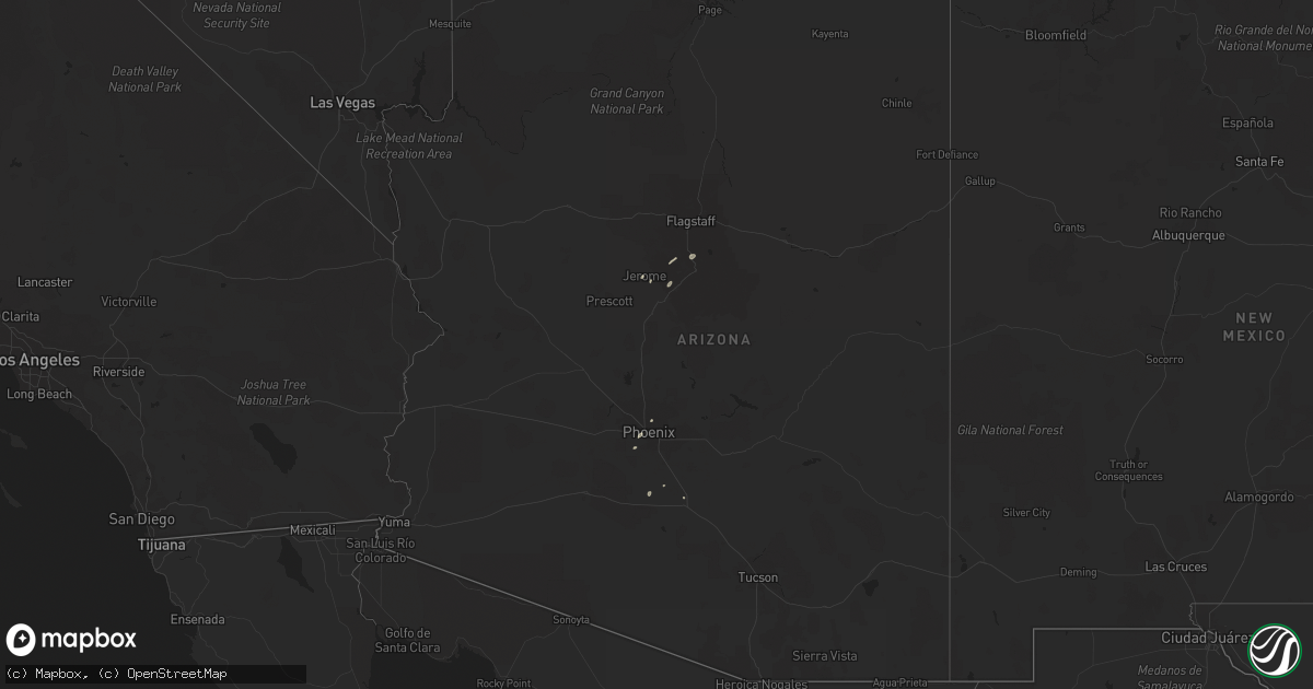
Hail Map in Arizona on June 23, 2022
Get this storm
June 23 map
$229
one time, instant access
Download today. No call, no setup
Keep the $229
Bought the map and want the full workflow? Apply the entire $229 to a subscription within 7 days. None of it is wasted.
Every map, not just this one
This buys you this map. Subscription and you get every map we run, in the markets you choose from a few cities to whole states to nationwide. Plus real-time alerts the moment a storm fires.
Contact data
Name, contact info, occupancy, even credit band for addresses in the footprint. You go from where it hit to who to call.
Become the source they trust
Unlimited branding weather history reports on demand. You already have the documented answer ready for the property owner, and you are the one who showed up with it.
Property data and RoofTrace estimates
Pull up any address you have got, its value and the exact code rules for that jurisdiction, straight from One Click Code. Then RoofTrace estimates the squares, pitch, and roof value, priced the way you price.
Storm reports in Arizona
Arizona
| Date | Description |
|---|---|
| 06/23/20225:31 PM CDT | Mesonet station as877 san tan valley. |
| 06/23/20224:21 PM CDT | Multiple reports from storm chasers and local media of multiple downed power lines... Trees... And a rolled rv along sr-347 between louis johnson dr and clayton rd. |
| 06/23/202212:29 AM CDT | At 529 PM MST, a severe thunderstorm was located near Village At Oak Creek, or 8 miles south of Sedona, moving northeast at 45 mph. HAZARD...60 mph wind gusts and quarter size hail. SOURCE...Radar indicated. IMPACT...Hail damage to vehicles is expected. Expect wind damage to roofs, siding, and trees. Locations impacted include... Camp Verde, Sedona, Munds Park, Mcguireville, Village At Oak Creek, Montezuma Castle National Monument, Montezuma Well, Rimrock, Middle Verde, Lake Montezuma, Cornville, Wet Beaver Creek Campground, Red Rock State Park, V Bar V Visitors Center and Manzanita Campground. |
| 06/22/202211:33 PM CDT | At 432 PM MST, a severe thunderstorm was located near South Mountain Park, or near Laveen, moving northeast at 15 mph. HAZARD...60 mph wind gusts. SOURCE...Radar indicated. IMPACT...Expect damage to roofs, siding, and trees. Locations impacted include... Phoenix, Glendale, Tempe, Avondale, Tolleson, Laveen, Papago Park, Arizona Mills Mall, South Phoenix, Arizona State Fairgrounds, South Mountain Park, Phoenix International Raceway, Downtown Phoenix, Arizona State University and Sky Harbor Airport.This includes the following highways...AZ Interstate 10 between mile markers 134 and 157.AZ Interstate 17 between mile markers 195 and 204.AZ Route 51 between mile markers 1 and 3. |
| 06/22/202211:25 PM CDT | At 425 PM MST, a severe thunderstorm was located over Piestewa Peak Park, or near Phoenix, moving northeast at 15 mph. HAZARD...60 mph wind gusts. SOURCE...Radar indicated. IMPACT...Expect damage to roofs, siding, and trees. Locations impacted include... Phoenix, Glendale, Scottsdale, Paradise Valley, New River, Cave Creek, Carefree, Papago Park, Piestewa Peak Park, Deer Valley Airport, McDowell Mountain Park, North Mountain Park, Downtown Scottsdale, Metro Center Mall and Scottsdale Airport.This includes the following highways...AZ Interstate 17 between mile markers 202 and 222.AZ Route 51 between mile markers 1 and 15.US Highway 60 between mile markers 153 and 160. |
| 06/22/202210:53 PM CDT | At 353 PM MST, a severe thunderstorm was located over Laveen, moving northeast at 15 mph. HAZARD...60 mph wind gusts. SOURCE...Radar indicated. IMPACT...Expect damage to roofs, siding, and trees. Locations impacted include... Phoenix, Glendale, Avondale, Paradise Valley, Tolleson, Laveen, Piestewa Peak Park, South Phoenix, Arizona State Fairgrounds, South Mountain Park, Phoenix International Raceway, Downtown Phoenix, Downtown Glendale, Camelback Mountain and Sky Harbor Airport.This includes the following highways...AZ Interstate 10 between mile markers 133 and 151.AZ Interstate 17 between mile markers 195 and 207.AZ Route 51 between mile markers 1 and 6. |
| 06/22/202210:00 PM CDT | At 300 PM MST, a severe thunderstorm was located near Casa Grande, moving northeast at 10 mph. HAZARD...60 mph wind gusts. SOURCE...Radar indicated. IMPACT...Expect damage to roofs, siding, and trees. Locations impacted include... Chandler, Casa Grande, Sun Lakes, Queen Creek, Blackwater, Chandler Heights, San Tan Valley, Seville, Bapchule, Olberg, Arizola, San Tan Mountain Park, Sacaton and Santan.This includes the following highways...AZ Interstate 10 between mile markers 172 and 202.AZ Interstate 8 between mile markers 164 and 178.AZ Route 87 between mile markers 137 and 162. |
| 06/22/20229:24 PM CDT | At 223 PM MST, a severe thunderstorm was located 7 miles south of Maricopa, or 20 miles west of Casa Grande, moving north at 20 mph. HAZARD...60 mph wind gusts. SOURCE...Radar indicated. IMPACT...Expect damage to roofs, siding, and trees. Locations impacted include... Maricopa, Estrella Sailport, Olberg, Stanfield and Ak- Chin Village.This includes the following highways...AZ Interstate 10 between mile markers 177 and 178.AZ Interstate 8 between mile markers 144 and 165.AZ Route 238 between mile markers 34 and 44. |
| 06/22/20228:23 PM CDT | At 122 PM MST, a severe thunderstorm was located over Freeman, or 22 miles east of Gila Bend, moving northeast at 10 mph. HAZARD...60 mph wind gusts. SOURCE...Radar indicated. IMPACT...Expect damage to roofs, siding, and trees. Locations impacted include... Estrella, Freeman and Big Horn. This includes the following highways...AZ Interstate 8 between mile markers 131 and 150.AZ Route 238 between mile markers 15 and 26.AZ Route 347 near mile marker 165. |
All States Impacted by Hail Map on June 23, 2022
Cities Impacted by Hail Map on June 23, 2022
- Minot, ND
- Kettle River, MN
- Barnum, MN
- Sedona, AZ
- Clarissa, MN
- Browerville, MN
- New Town, ND
- Parshall, ND
- Oak Hill, FL
- Clarkdale, AZ
- Abbeville, LA
- Brainerd, MN
- Cotton, MN
- Makinen, MN
- Shell Knob, MO
- Lampe, MO
- Green Forest, AR
- Berryville, AR
- Sebeka, MN
- Gaylord, KS
- Aitkin, MN
- Bottineau, ND
- Malta, MT
- Ogilvie, MN
- Braham, MN
- Mora, MN
- Fergus Falls, MN
- Maricopa, AZ
- Norwich, ND
- Velva, ND
- Sawyer, ND
- Coushatta, LA
- Osborne, KS
- Duluth, MN
- Des Lacs, ND
- Altoona, FL
- Delphos, KS
- Westhope, ND
- Lansford, ND
- Maxbass, ND
- Souris, ND
- Newburg, ND
- Glasco, KS
- McLaughlin, SD
- Detroit Lakes, MN
- Park Rapids, MN
- Menahga, MN
- Neche, ND
- Maida, ND
- Walhalla, ND
- Langdon, ND
- Cavalier, ND
- Pfeifer, KS
- Houma, LA
- Gray, LA
- Mims, FL
- Titusville, FL
- Mohall, ND
- Riley, KS
- Fort Riley, KS
- Junction City, KS
- Manhattan, KS
- Milford, KS
- Dupree, SD
- Provencal, LA
- Flatwoods, LA
- Brook Park, MN
- Forbes, ND
- Becker, MN
- Saginaw, MN
- Hanksville, UT
- Port Orange, FL
- Mcgregor, MN
- Cottonwood, AZ
- Edgewater, FL
- Eureka, SD
- Isle, MN
- Cawker City, KS
- Downs, KS
- Glen Elder, KS
- Laveen, AZ
- Thomasville, AL
- Wakefield, KS
- Hunter, KS
- Tipton, KS
- Beloit, KS
- San Augustine, TX
- Bronson, TX
- Dunseith, ND
- Uniontown, AL
- Newbern, AL
- Carson, IA
- Bertha, MN
- Ocala, FL
- Seligman, MO
- Daytona Beach, FL
- Waynesboro, MS
- Jasper, AR
- Stanchfield, MN
- Sauk Rapids, MN
- Sartell, MN
- Finland, MN
- Ponsford, MN
- Osage, MN
- Cromwell, MN
- Sawyer, MN
- Wright, MN
- Floodwood, MN
- Jacobson, MN
- Palisade, MN
- Cloquet, MN
- Tamarack, MN
- Eagle Butte, SD
- Haines City, FL
- Motley, MN
- Staples, MN
- Dulac, LA
- Ashley, ND
- Long Lake, SD
- Leola, SD
- Milaca, MN
- Nisswa, MN
- Pequot Lakes, MN
- Albany, MN
- Tescott, KS
- Beverly, KS
- Wadena, MN
- Verndale, MN
- Singer, LA
- Deridder, LA
- Glenham, SD
- Mound City, SD
- Herreid, SD
- Big Lake, MN
- Zimmerman, MN
- Saint Cloud, MN
- Clear Lake, MN
- Elk River, MN
- Walker, SD
- Selfridge, ND
- Phoenix, AZ
- Moose Lake, MN
- Allendale, SC
- Pollock, SD
- Winnsboro, SC
- Courtland, KS
- Underwood, MN
- Battle Lake, MN
- Edgeley, ND
- New York Mills, MN
- Deer Creek, MN
- Vining, MN
- Ottertail, MN
- Henning, MN
- Clitherall, MN
- Luray, KS
- Waldo, KS
- Blackville, SC
- Barnwell, SC
- Pierz, MN
- Cushing, MN
- Randall, MN
- Baxter, MN
- Little Falls, MN
- Hillman, MN
- Long Prairie, MN
- Pillager, MN
- Fort Ripley, MN
- Grand View, ID
- Dorrance, KS
- Bunker Hill, KS
- Russell, KS
- Natoma, KS
- Paradise, KS
- Sweet Water, AL
- Lucas, KS
- Gorham, KS
- Sylvan Grove, KS
- Esbon, KS
- Mankato, KS
- Hoven, SD
- Gettysburg, SD
- Schriever, LA
- Java, SD
- Teasdale, UT
- Crosby, MN
- Saint Joseph, MN
- Waite Park, MN
- Victoria, KS
- Brookville, KS
- Lincoln, KS
- Simpson, KS
- Clay Center, KS
- Miltonvale, KS
- Gilmer, TX
- Longford, KS
- Winslow, AZ
- Blackstock, SC
- Titus, AL
- Wetumpka, AL
- Nodaway, IA
- New Iberia, LA
- Jewell, KS
- Casa Grande, AZ
- Munds Park, AZ
- Merrifield, MN
- Avon, MN
- Grand Marais, MN
- Glasgow, MT
- Saint Marie, MT
- Tolstoy, SD
- Rice, MN
- Royalton, MN
- Onaka, SD
- Grasston, MN
- De Berry, TX
- Minneapolis, KS
- Kulm, ND
- Olar, SC
- Williston, SC
- Theriot, LA
- Clearwater, MN
- Saint Stephen, MN
- Foley, MN
- Alton, KS
- Leupp, AZ
- Fort Peck, MT
- Bluffton, MN
- Aldrich, MN
- Garrison, MN
- Swanville, MN
- Montegut, LA
- Alpena, AR
- Omaha, AR
- Bremen, GA
- Wakpala, SD
- Deerwood, MN
- Lena, LA
- Leesville, LA
- Ocklawaha, FL
- Salt Lake City, UT
- Sandy, UT
- Wilson, KS
- Ellsworth, KS
- Compton, AR
- Ironton, MN
- Sturgeon Lake, MN
- Carlton, MN
- Two Harbors, MN
- Richville, MN


