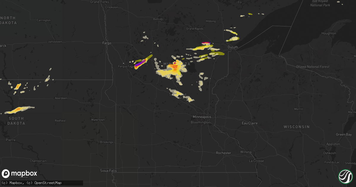
Hail Map on June 23, 2022
Get this storm
June 23 map
$229
one time, instant access
Download today. No call, no setup
Keep the $229
Bought the map and want the full workflow? Apply the entire $229 to a subscription within 7 days. None of it is wasted.
Every map, not just this one
This buys you this map. Subscription and you get every map we run, in the markets you choose from a few cities to whole states to nationwide. Plus real-time alerts the moment a storm fires.
Contact data
Name, contact info, occupancy, even credit band for addresses in the footprint. You go from where it hit to who to call.
Become the source they trust
Unlimited branding weather history reports on demand. You already have the documented answer ready for the property owner, and you are the one who showed up with it.
Property data and RoofTrace estimates
Pull up any address you have got, its value and the exact code rules for that jurisdiction, straight from One Click Code. Then RoofTrace estimates the squares, pitch, and roof value, priced the way you price.
States Impacted by Hail Map on June 23, 2022
Storm reports
Florida
| Date | Description |
|---|---|
| 06/23/20223:45 PM CDT | Corrects previous tstm wnd dmg report from 3 nw silver springs shores. Multiple trees and powerlines down along se 55th pl. Trees and powerlines were reported to be twi |
| 06/23/20223:45 PM CDT | Multiple trees downed or snapped... Power lines downed and people without power near midway rd... Bahia rd and spring rd. Large trees of about 8 to 10 ft in circumferen |
| 06/23/20223:45 PM CDT | Multiple trees and powerlines down along se 55th pl. Trees and powerlines were reported to be twisted together. Possible tornado damage. Further survey needed to determ |
| 06/23/20223:18 PM CDT | Multiple trees and powerlines down along ne jacksonville rd extending from 49th st to 90th st. Time estimated by radar. |
| 06/23/20222:13 AM CDT | At 712 PM EDT, a severe thunderstorm was located near Oak Hill, moving south at 15 mph. HAZARD...60 mph wind gusts and penny size hail. SOURCE...Radar indicated. IMPACT...Expect damage to roofs, siding, and trees. Locations impacted include... Titusville, Oak Hill, Haulover Canal, Mims and Scottsmoor. |
| 06/23/202212:13 AM CDT | At 512 PM EDT, a severe thunderstorm was located near Pittman, or 9 miles south of Juniper Springs, moving southeast at 10 mph. HAZARD...60 mph wind gusts and quarter size hail. SOURCE...Radar indicated. IMPACT...Hail damage to vehicles is expected. Expect wind damage to roofs, siding, and trees. Locations impacted include... Eustis, Pittman, Umatilla, Lake Yale and Lake Dorr. |
| 06/22/202211:58 PM CDT | At 458 PM EDT, a severe thunderstorm was located near Pittman, or 7 miles southeast of Juniper Springs, moving south at 15 mph. HAZARD...60 mph wind gusts and nickel size hail. SOURCE...Radar indicated. IMPACT...Expect damage to roofs, siding, and trees. This severe thunderstorm will remain over mainly rural areas of southeastern Marion County. |
| 06/22/202211:51 PM CDT | At 451 PM EDT, a severe thunderstorm was located near Silver Springs Shores, or near Lynne, moving southeast at 20 mph. HAZARD...60 mph wind gusts and penny size hail. SOURCE...Radar indicated. IMPACT...Expect damage to roofs, siding, and trees. Locations impacted include... Ocklawaha, Moss Bluff, Lake Weir and Silver Springs Shores. |
Minnesota
| Date | Description |
|---|---|
| 06/23/20226:55 PM CDT | Report via social media with photo. |
| 06/23/20226:50 PM CDT | A local report indicates 1.00 inch wind near 1 SE CROSBY |
| 06/23/20226:46 PM CDT | Report from mping: quarter |
| 06/23/20226:45 PM CDT | Report via social media with photo. |
| 06/23/20226:40 PM CDT | A local report indicates 1.75 inch wind near 1 SW BRAINERD |
| 06/23/20226:40 PM CDT | A local report indicates 1.00 inch wind near CROSBY |
| 06/23/20226:40 PM CDT | Report via social media with ruler photo. |
| 06/23/20226:39 PM CDT | Report from mping: quarter |
| 06/23/20226:38 PM CDT | A local report indicates 1.00 inch wind near 1 S CROSBY |
| 06/23/20226:29 PM CDT | Report via social media with measurement picture. |
| 06/23/20226:27 PM CDT | A local report indicates 1.00 inch wind near 1 WNW BRAINERD |
| 06/23/20226:26 PM CDT | A local report indicates 1.00 inch wind near 2 SW BRAINERD |
| 06/23/20226:15 PM CDT | Two rounds of golf ball size hail... With the first round being about 15 minutes earlier than the time listed. Location approximate. Report received via facebook. |
| 06/23/20226:13 PM CDT | Report from mping: ping pong ball |
| 06/23/20226:10 PM CDT | Report via social media with photo. |
| 06/23/20226:10 PM CDT | A local report indicates 1.00 inch wind near 1 WNW BRAINERD |
| 06/23/20226:10 PM CDT | Report from mping: quarter |
| 06/23/20226:09 PM CDT | Report via social media with photo. |
| 06/23/20226:07 PM CDT | A local report indicates 1.75 inch wind near 2 NE BAXTER |
| 06/23/20225:21 PM CDT | A local report indicates 1.50 inch wind near 8 S MOTLEY |
| 06/23/20226:59 AM CDT | A local report indicates 2.75 inch wind near 6 S OTTERTAIL |
| 06/23/20226:50 AM CDT | A local report indicates 1.00 inch wind near 4 S NEW YORK MILLS |
| 06/23/20226:32 AM CDT | A local report indicates 2.50 inch wind near BATTLE LAKE |
| 06/23/20226:31 AM CDT | A local report indicates 1.00 inch wind near BATTLE LAKE |
| 06/23/20225:35 AM CDT | At 1035 PM CDT, a severe thunderstorm was located over Randall, or 11 miles northwest of Little Falls, moving southeast at 25 mph. HAZARD...60 mph wind gusts and half dollar size hail. SOURCE...Radar indicated. IMPACT...Hail damage to vehicles is expected. Expect wind damage to roofs, siding, and trees. This severe thunderstorm will be near... Camp Ripley around 1050 PM CDT. |
| 06/23/20225:08 AM CDT | At 1006 PM CDT, severe thunderstorms were located along a line extending from Quamba, to 7 miles east of Grantsburg, moving southeast at 25 mph. HAZARD...60 mph wind gusts and quarter size hail. SOURCE...Trained weather spotters reported funnel clouds near Grantsburg. IMPACT...Hail damage to vehicles is expected. Expect wind damage to roofs, siding, and trees. Severe thunderstorms will be near... Siren around 1025 PM CDT.Other locations in the path of these severe thunderstorms includePine City, Rock Creek and Grantsburg. |
| 06/23/20224:57 AM CDT | At 957 PM CDT, a severe thunderstorm was located near Knife River, or 22 miles northeast of Superior, moving east at 25 mph. HAZARD...60 mph wind gusts and half dollar size hail. SOURCE...Radar indicated. IMPACT...Hail damage to vehicles is expected. Expect wind damage to roofs, siding, and trees. This severe thunderstorm will be near... Stoney Point around 1000 PM CDT. Larsmont and Knife River around 1010 PM CDT.Other locations in the path of this severe thunderstorm include TwoHarbors and Castle Danger. |
| 06/23/20224:21 AM CDT | At 921 PM CDT, severe thunderstorms were located along a line extending from 8 miles west of Vineland, to near Fort Ripley, moving southeast at 15 mph. HAZARD...60 mph wind gusts and half dollar size hail. SOURCE...Radar indicated. IMPACT...Hail damage to vehicles is expected. Expect wind damage to roofs, siding, and trees. These severe thunderstorms will remain over mainly rural areas of southwestern Crow Wing County, including the following locations... Erskin Lake. |
| 06/23/20224:18 AM CDT | At 917 PM CDT, a severe thunderstorm was located 11 miles east of Boulder Lake, or 27 miles north of Superior, moving east at 15 mph. HAZARD...Quarter size hail. SOURCE...Radar indicated. IMPACT...Damage to vehicles is expected. Locations impacted include... Larsmont and Two Harbors. |
| 06/23/20224:14 AM CDT | At 914 PM CDT, a severe thunderstorm was located 6 miles southeast of Saint Mathias, or 13 miles northeast of Little Falls, moving east at 35 mph. HAZARD...60 mph wind gusts and half dollar size hail. SOURCE...Radar indicated. IMPACT...Hail damage to vehicles is expected. Expect wind damage to roofs, siding, and trees. This severe thunderstorm will be near... Lastrup around 930 PM CDT. |
| 06/23/20224:08 AM CDT | At 908 PM CDT, a severe thunderstorm was located near Pike Lake Near Duluth, or 15 miles northeast of Cloquet, moving east at 25 mph. HAZARD...60 mph wind gusts and half dollar size hail. SOURCE...Radar indicated. IMPACT...Hail damage to vehicles is expected. Expect wind damage to roofs, siding, and trees. This severe thunderstorm will be near... Hermantown around 925 PM CDT.Other locations in the path of this severe thunderstorm includeIsland Lake, City of Rice Lake, French River and Stoney Point. |
| 06/23/20223:44 AM CDT | At 844 PM CDT, a severe thunderstorm was located over Fort Ripley, or 14 miles north of Little Falls, moving east at 20 mph. HAZARD...Quarter size hail. SOURCE...Radar indicated. IMPACT...Damage to vehicles is expected. Locations impacted include... Saint Mathias. |
| 06/23/20223:43 AM CDT | At 843 PM CDT, a severe thunderstorm was located over Fort Ripley, or 13 miles north of Little Falls, moving east at 35 mph. HAZARD...60 mph wind gusts and half dollar size hail. SOURCE...Radar indicated. IMPACT...Hail damage to vehicles is expected. Expect wind damage to roofs, siding, and trees. This severe thunderstorm will remain over mainly rural areas of central Morrison County. |
| 06/23/20223:37 AM CDT | At 836 PM CDT, a severe thunderstorm was located 8 miles north of Boulder Lake, or 31 miles north of Superior, moving east at 20 mph. HAZARD...60 mph wind gusts and quarter size hail. SOURCE...Radar indicated. IMPACT...Hail damage to vehicles is expected. Expect wind damage to roofs, siding, and trees. This severe thunderstorm will remain over mainly rural areas of southeastern St. Louis County, including the following locations... Pequaywan Lake and Comstock Lake. |
| 06/23/20223:30 AM CDT | At 830 PM CDT, a severe thunderstorm was located 6 miles southwest of Vineland, or 14 miles southwest of Mille Lacs Lake, moving southeast at 15 mph. HAZARD...60 mph wind gusts and half dollar size hail. SOURCE...Radar indicated. IMPACT...Hail damage to vehicles is expected. Expect wind damage to roofs, siding, and trees. This severe thunderstorm will be near... Vineland around 845 PM CDT.Other locations in the path of this severe thunderstorm includeOnamia and Wahkon. |
| 06/23/20223:23 AM CDT | At 823 PM CDT, severe thunderstorms were located along a line extending from near Garrison, to near Vineland, to near Saint Mathias, moving southeast at 10 mph. HAZARD...60 mph wind gusts and half dollar size hail. SOURCE...Radar indicated. IMPACT...Hail damage to vehicles is expected. Expect wind damage to roofs, siding, and trees. Severe thunderstorms will be near... Garrison around 840 PM CDT.Other locations in the path of these severe thunderstorms includeMille Lacs Lake and Malmo. |
| 06/23/20223:10 AM CDT | At 809 PM CDT, a severe thunderstorm was located near Big Sandy Lake, moving east at 35 mph. HAZARD...60 mph wind gusts and quarter size hail. SOURCE...Radar indicated. IMPACT...Hail damage to vehicles is expected. Expect wind damage to roofs, siding, and trees. Locations impacted include... Floodwood and Fond Du Lac Band Brookston Area. |
| 06/23/20222:48 AM CDT | At 748 PM CDT, a severe thunderstorm was located near Cotton, or 31 miles southeast of Hibbing, moving east at 20 mph. HAZARD...Half dollar size hail. SOURCE...Radar indicated. IMPACT...Damage to vehicles is expected. Locations impacted include... Wolf Lake. |
| 06/23/20222:46 AM CDT | At 746 PM CDT, a severe thunderstorm was located near Baxter, or 7 miles southwest of Brainerd, moving east at 10 mph. HAZARD...Ping pong ball size hail and 60 mph wind gusts. SOURCE...Trained weather spotters. IMPACT...People and animals outdoors will be injured. Expect hail damage to roofs, siding, windows, and vehicles. Expect wind damage to roofs, siding, and trees. This severe thunderstorm will be near... Baxter around 800 PM CDT. Saint Mathias around 805 PM CDT.Other locations in the path of this severe thunderstorm includeBrainerd. |
| 06/23/20222:35 AM CDT | At 733 PM CDT, a severe thunderstorm was located 10 miles northwest of Hovland, or 19 miles northeast of Grand Marais, moving east at 30 mph. HAZARD...60 mph wind gusts and quarter size hail. SOURCE...Radar indicated. IMPACT...Hail damage to vehicles is expected. Expect wind damage to roofs, siding, and trees. This severe thunderstorm will be near... Hovland around 750 PM CDT.Other locations in the path of this severe thunderstorm include GrandPortage. |
| 06/23/20222:33 AM CDT | At 733 PM CDT, a severe thunderstorm was located near Upper South Long Lake, or 9 miles east of Brainerd, moving east at 15 mph. HAZARD...Golf ball size hail. SOURCE...Radar indicated. IMPACT...People and animals outdoors will be injured. Expect damage to roofs, siding, windows, and vehicles. Locations impacted include... Garrison. |
| 06/23/20222:32 AM CDT | At 732 PM CDT, severe thunderstorms were located along a line extending from 10 miles west of Palisade, to near Cuyuna, moving east at 20 mph. HAZARD...Quarter size hail. SOURCE...Radar indicated. IMPACT...Damage to vehicles is expected. Locations impacted include... Aitkin, Palisade, Big Sandy Lake and Libby. |
| 06/23/20222:30 AM CDT | A local report indicates 1.00 inch wind near WAITE PARK |
| 06/23/20222:21 AM CDT | At 721 PM CDT, a severe thunderstorm was located near Mille Lacs Band East Lake Area, or 20 miles south of Big Sandy Lake, moving east at 30 mph. HAZARD...Ping pong ball size hail. SOURCE...Radar indicated. IMPACT...People and animals outdoors will be injured. Expect damage to roofs, siding, windows, and vehicles. Locations impacted include... Kettle River. |
| 06/23/20222:16 AM CDT | At 716 PM CDT, a severe thunderstorm was located over Pillager, or 12 miles west of Brainerd, moving east at 20 mph. HAZARD...60 mph wind gusts and half dollar size hail. SOURCE...Radar indicated. IMPACT...Hail damage to vehicles is expected. Expect wind damage to roofs, siding, and trees. Locations impacted include... Baxter. |
| 06/23/20222:15 AM CDT | At 714 PM CDT, a severe thunderstorm was located over Pillager, or 11 miles west of Brainerd, moving east at 20 mph. HAZARD...Ping pong ball size hail and 60 mph wind gusts. SOURCE...Radar indicated. IMPACT...People and animals outdoors will be injured. Expect hail damage to roofs, siding, windows, and vehicles. Expect wind damage to roofs, siding, and trees. This severe thunderstorm will remain over mainly rural areas of northwestern Morrison County, including the following locations... Crow Wing State Park. |
| 06/23/20222:11 AM CDT | At 711 PM CDT, a severe thunderstorm was located near Aitkin, or 15 miles north of Mille Lacs Lake, moving east at 35 mph. HAZARD...60 mph wind gusts and quarter size hail. SOURCE...Radar indicated. IMPACT...Hail damage to vehicles is expected. Expect wind damage to roofs, siding, and trees. Locations impacted include... Mille Lacs Band East Lake Area, McGregor and Tamarack. |
| 06/23/20222:03 AM CDT | At 702 PM CDT, a severe thunderstorm was located 10 miles southeast of Babbitt, or 24 miles south of Ely, moving east at 25 mph. HAZARD...60 mph wind gusts and quarter size hail. SOURCE...Radar indicated. IMPACT...Hail damage to vehicles is expected. Expect wind damage to roofs, siding, and trees. Locations impacted include... Whyte, Isabella and Dumbbell Lake. |
| 06/23/20221:55 AM CDT | Report from mping: quarter |
| 06/23/20221:55 AM CDT | A local report indicates 1.00 inch wind near 1 W ST. CLOUD |
| 06/23/20221:55 AM CDT | Mping report. |
| 06/23/20221:47 AM CDT | At 646 PM CDT, a severe thunderstorm was located 9 miles northeast of Big Sandy Lake, moving east at 20 mph. HAZARD...Half dollar size hail. SOURCE...Radar indicated. IMPACT...Damage to vehicles is expected. Locations impacted include... Floodwood. |
| 06/23/20221:45 AM CDT | At 644 PM CDT, a severe thunderstorm was located 7 miles east of Gunflint Lake, moving east at 30 mph. HAZARD...60 mph wind gusts and half dollar size hail. SOURCE...Radar indicated. IMPACT...Hail damage to vehicles is expected. Expect wind damage to roofs, siding, and trees. Locations impacted include... Boundary Waters Canoe Area Wilderness North of the Gunflint Trail. |
| 06/23/20221:44 AM CDT | At 644 PM CDT, a severe thunderstorm was located near Saint Mathias, or near Brainerd, moving east at 15 mph. HAZARD...Golf ball size hail. SOURCE...Radar indicated. IMPACT...People and animals outdoors will be injured. Expect damage to roofs, siding, windows, and vehicles. This severe thunderstorm will be near... Brainerd around 700 PM CDT.Other locations in the path of this severe thunderstorm include SouthLong Lake, Upper South Long Lake and Garrison. |
| 06/23/20221:25 AM CDT | At 625 PM CDT, a severe thunderstorm was located over Garrison, or near Mille Lacs Lake, moving east at 40 mph. HAZARD...Quarter size hail. SOURCE...Radar indicated. IMPACT...Damage to vehicles is expected. This severe thunderstorm will be near... Mille Lacs Lake and Malmo around 645 PM CDT. |
| 06/23/20221:06 AM CDT | At 606 PM CDT, a severe thunderstorm was located near Gull Lake, or near Brainerd, moving east at 25 mph. HAZARD...Ping pong ball size hail and 60 mph wind gusts. SOURCE...Radar indicated. IMPACT...People and animals outdoors will be injured. Expect hail damage to roofs, siding, windows, and vehicles. Expect wind damage to roofs, siding, and trees. This severe thunderstorm will be near... Brainerd around 615 PM CDT. Merrifield around 620 PM CDT.Other locations in the path of this severe thunderstorm includeIronton, Crosby and Cuyuna. |
| 06/23/202212:59 AM CDT | At 559 PM CDT, a severe thunderstorm was located near Pillager, or 13 miles southwest of Brainerd, moving east at 25 mph. HAZARD...60 mph wind gusts and half dollar size hail. SOURCE...Radar indicated. IMPACT...Hail damage to vehicles is expected. Expect wind damage to roofs, siding, and trees. Locations impacted include... Saint Mathias, Baxter, Brainerd, South Long Lake and Upper South Long Lake. |
| 06/22/202210:21 PM CDT | Facebook picture of a large aspen down across road. Time and location approximated. |
| 06/22/202210:15 PM CDT | Reporter was not sure on the exact time and estimated 945 pm... But said the radar showed the storms to the north. There is a velocity signature that occurred near the |
| 06/22/20229:49 PM CDT | Report via social media with photo. |
| 06/22/20229:35 PM CDT | A local report indicates 1.00 inch wind near FORT RIPLEY |
| 06/22/20229:25 PM CDT | A local report indicates 1.50 inch wind near 3 SSW SAINT MATHIAS |
| 06/22/20229:22 PM CDT | Tree blown down crushing screen house. |
| 06/22/20229:16 PM CDT | A local report indicates 1.00 inch wind near 2 WSW FREDENBERG |
| 06/22/20229:07 PM CDT | A local report indicates 1.25 inch wind near FORT RIPLEY |
| 06/22/20229:05 PM CDT | A local report indicates 1.25 inch wind near 1 N FORT RIPLEY |
| 06/22/20228:45 PM CDT | A local report indicates 1.00 inch wind near 7 SE BRAINERD |
| 06/22/20228:42 PM CDT | Report via social media with picture. |
| 06/22/20228:27 PM CDT | Winds lofted a trampoline across the yard and over a pool. Time and location approximated from radar. |
| 06/22/20228:15 PM CDT | Report via social media with picture. |
| 06/22/20228:11 PM CDT | Report via social media with photo. |
| 06/22/20228:10 PM CDT | Report via social media with ruler photo. |
| 06/22/20228:07 PM CDT | Some quarter size hailstones with lots of smaller stones. |
| 06/22/20228:04 PM CDT | Report via social media with photo. |
| 06/22/20228:02 PM CDT | Report received via facebook. Pictures and video show hail sizes measured up to 2 inches in diameter. |
| 06/22/20228:00 PM CDT | Branches of various sizes broken. Swamp filled with water. Time approximated. 2.53 inches of rain. |
| 06/22/20227:55 PM CDT | A local report indicates 1.00 inch wind near BAXTER |
| 06/22/20227:55 PM CDT | Report via social media with photo. |
| 06/22/20227:55 PM CDT | Report 1 medium size tree snapped at base in backyard. |
| 06/22/20227:52 PM CDT | A local report indicates 1.00 inch wind near 1 SW BAXTER |
| 06/22/20227:50 PM CDT | Report via social media with photo. |
| 06/22/20227:50 PM CDT | A local report indicates 1.00 inch wind near LAWLER |
| 06/22/20227:40 PM CDT | Report via social media with photos of multiple medium to large trees snapped at base down over roads and power lines. Time estimated from report and radar. |
| 06/22/20227:36 PM CDT | A local report indicates 1.00 inch wind near 3 NW LAWLER |
| 06/22/20227:35 PM CDT | A local report indicates 1.00 inch wind near 3 S AITKIN |
| 06/22/20227:35 PM CDT | Report via social media with photo. |
| 06/22/20227:35 PM CDT | A local report indicates 1.75 inch wind near 4 E PILLAGER |
| 06/22/20227:25 PM CDT | Delayed report... Time estimated from radar. |
| 06/22/20227:20 PM CDT | Corrects previous tstm wnd dmg report from 7 ese brainerd. Large tree snapped roughly 5 feet up from base. Report with photo. |
| 06/22/20227:00 PM CDT | Report via social media with photo. |
South Dakota
| Date | Description |
|---|---|
| 06/23/20226:38 AM CDT | At 1138 PM CDT, a severe thunderstorm was located 9 miles south of Lowry, or 13 miles north of Gettysburg, moving east at 25 mph. HAZARD...60 mph wind gusts and quarter size hail. SOURCE...Radar indicated. IMPACT...Hail damage to vehicles is expected. Expect wind damage to roofs, siding, and trees. Locations impacted include... Hoven and Tolstoy. |
| 06/23/20225:45 AM CDT | At 1045 PM CDT, a severe thunderstorm was located over Mound City, or 17 miles north of Selby, moving north at 25 mph. HAZARD...60 mph wind gusts and quarter size hail. SOURCE...Radar indicated. IMPACT...Hail damage to vehicles is expected. Expect wind damage to roofs, siding, and trees. This severe thunderstorm will be near... Herreid around 1100 PM CDT. |
| 06/23/20225:41 AM CDT | At 1040 PM CDT/940 PM MDT/, a severe thunderstorm was located over Swiftbird Day School, or 25 miles west of Gettysburg, moving east at 25 mph. HAZARD...60 mph wind gusts and half dollar size hail. SOURCE...Radar indicated. IMPACT...Hail damage to vehicles is expected. Expect wind damage to roofs, siding, and trees. This severe thunderstorm will be near... Swiftbird around 950 PM MDT.Other locations in the path of this severe thunderstorm includeWhitlocks Bay Rec Area. |
| 06/23/20223:14 AM CDT | At 813 PM MDT, a severe thunderstorm was located 8 miles southeast of Parade, or 14 miles east of Eagle Butte, moving southeast at 10 mph. HAZARD...Tennis ball size hail and 60 mph wind gusts. SOURCE...Radar indicated. IMPACT...People and animals outdoors will be injured. Expect hail damage to roofs, siding, windows, and vehicles. Expect wind damage to roofs, siding, and trees. This severe thunderstorm will remain over mainly rural areas of south central Dewey County. |
| 06/23/20222:29 AM CDT | At 729 PM MDT, a severe thunderstorm was located over Parade, or 9 miles east of Eagle Butte, moving southeast at 10 mph. HAZARD...Half dollar size hail. SOURCE...Radar indicated. IMPACT...Damage to vehicles is expected. This severe thunderstorm will remain over mainly rural areas of south central Dewey County, including the following locations... Cheyenne River Reservation. |
| 06/22/202211:41 PM CDT | A local report indicates 1.75 inch wind near 10 S AKASKA |
| 06/22/202211:21 PM CDT | Corrects time of previous hail report from 10 s akaska. |
| 06/22/202210:54 PM CDT | Relayed through social media. |
| 06/22/20229:00 PM CDT | 50 to 60 mph winds reported as well. |
Idaho
| Date | Description |
|---|---|
| 06/23/202212:39 AM CDT | At 538 PM MDT, a severe thunderstorm was located over Payne Creek Reservoir, or 22 miles north of Owyhee, moving east at 5 mph. HAZARD...60 mph wind gusts and quarter size hail. SOURCE...Radar indicated. IMPACT...Hail damage to vehicles is expected. Expect wind damage to roofs, siding, and trees. Locations impacted include... Payne Creek Reservoir, Tindall Ranch, Highway 51 and Grasmere. |
Kansas
| Date | Description |
|---|---|
| 06/23/20226:39 PM CDT | Brief tornado touch down around 10 miles north of ellsworth. Tornado lasted about 1 minute. |
| 06/23/20226:38 PM CDT | Windows broken out at bank from hail. |
| 06/23/20226:34 PM CDT | Report from mping: ping pong ball |
| 06/23/20226:20 PM CDT | Brief tornado touch down around 6 miles south of sylvan grove. |
| 06/23/20225:54 PM CDT | Multiple reports of of a brief touchdown just northeast of dorrance. |
| 06/23/20225:29 PM CDT | Delayed hail report west of wilson lake. |
| 06/23/20225:25 PM CDT | Brief tornado touchdown 3-5 miles northeast of bunker hill. |
| 06/23/20224:32 PM CDT | A local report indicates 1.00 inch wind near 1 N RUSSELL |
| 06/23/20223:54 PM CDT | Estimated 50-60 mph winds in russell. |
| 06/23/20226:44 AM CDT | At 1144 PM CDT, a severe thunderstorm was located near Ionia, or 21 miles northwest of Beloit, moving northeast at 20 mph. HAZARD...60 mph wind gusts and half dollar size hail. SOURCE...Radar indicated. IMPACT...Hail damage to vehicles is expected. Expect wind damage to roofs, siding, and trees. Locations impacted include... Jewell and Mankato. |
| 06/23/20225:11 AM CDT | At 1011 PM CDT, a severe thunderstorm was located over Gaylord, or 25 miles east of Phillipsburg, moving northeast at 15 mph. HAZARD...60 mph wind gusts and penny size hail. SOURCE...Radar indicated. IMPACT...Expect damage to roofs, siding, and trees. This severe thunderstorm will be near... Gaylord around 1020 PM CDT. Harlan around 1025 PM CDT.Other locations in the path of this severe thunderstorm include SmithCenter. |
| 06/23/20224:23 AM CDT | At 922 PM CDT, a severe thunderstorm was located 5 miles southwest of Asherville, moving east at 20 mph. HAZARD...60 mph wind gusts and half dollar size hail. SOURCE...Radar indicated. IMPACT...Hail damage to vehicles is expected. Expect wind damage to roofs, siding, and trees. Locations impacted include... Glasco and Delphos. |
| 06/23/20224:08 AM CDT | At 907 PM CDT, a severe thunderstorm was located 8 miles south of Beloit, moving east at 25 mph. THIS IS A DESTRUCTIVE STORM FOR southeast Mitchell County! HAZARD...Baseball size hail and 60 mph wind gusts. SOURCE...Radar indicated. IMPACT...People and animals outdoors will be severely injured. Expect shattered windows, extensive damage to roofs, siding, and vehicles. Locations impacted include... Asherville and Simpson. |
| 06/23/20223:32 AM CDT | At 832 PM CDT, a severe thunderstorm was located near Victor, or 16 miles southwest of Beloit, moving east at 30 mph. HAZARD...Ping pong ball size hail and 60 mph wind gusts. SOURCE...Radar indicated. IMPACT...People and animals outdoors will be injured. Expect hail damage to roofs, siding, windows, and vehicles. Expect wind damage to roofs, siding, and trees. This severe thunderstorm will be near... Victor around 840 PM CDT.Other locations in the path of this severe thunderstorm includeAsherville and Simpson. |
| 06/23/20223:10 AM CDT | At 810 PM CDT, a severe thunderstorm was located over Tipton, or 23 miles west of Beloit, moving east at 25 mph. HAZARD...60 mph wind gusts and quarter size hail. SOURCE...Radar indicated. IMPACT...Hail damage to vehicles is expected. Expect wind damage to roofs, siding, and trees. This severe thunderstorm will be near... Tipton around 815 PM CDT.Other locations in the path of this severe thunderstorm include GlenElder. |
| 06/23/20222:30 AM CDT | At 730 PM CDT, a severe thunderstorm was located 12 miles northeast of Natoma, or 26 miles north of Russell, moving northeast at 20 mph. HAZARD...60 mph wind gusts and quarter size hail. SOURCE...Radar indicated. IMPACT...Hail damage to vehicles is expected. Expect wind damage to roofs, siding, and trees. Locations impacted include... Osborne. |
| 06/23/20221:32 AM CDT | At 632 PM CDT, a severe thunderstorm was located over Luray, or 18 miles northeast of Russell, moving northeast at 30 mph. HAZARD...60 mph wind gusts and quarter size hail. SOURCE...Radar indicated. IMPACT...Hail damage to vehicles is expected. Expect wind damage to roofs, siding, and trees. Locations impacted include... Hunter and Tipton. |
| 06/23/20221:30 AM CDT | At 630 PM CDT, a severe thunderstorm was located over Luray, or 17 miles northeast of Russell, moving east to northeast at 30 mph. HAZARD...70 mph wind gusts and ping pong ball size hail. SOURCE...Radar indicated. IMPACT...People and animals outdoors will be injured. Expect hail damage to roofs, siding, windows, and vehicles. Expect considerable tree damage. Wind damage is also likely to mobile homes, roofs, and outbuildings. Locations impacted include... Lucas, Luray, Barnard, Waldo and Ash Grove. |
| 06/22/202211:28 PM CDT | At 427 PM CDT, a severe thunderstorm was located over Russell, moving northeast at 25 mph. HAZARD...60 mph wind gusts and quarter size hail. SOURCE...Radar indicated. IMPACT...Hail damage to vehicles is expected. Expect wind damage to roofs, siding, and trees. Locations impacted include... Russell, Lucas, Gorham, Luray, Dorrance, Milberger, Bunker Hill, Paradise, Waldo, Wilson State Park, Wilson Lake and Russell Airport.This includes Interstate 70 between Mile Markers 175 and 204. |
| 06/22/202210:55 PM CDT | At 355 PM CDT, a severe thunderstorm was located near Luray, or 12 miles northeast of Russell, moving northeast at 40 mph. HAZARD...60 mph wind gusts and quarter size hail. SOURCE...Radar indicated. IMPACT...Hail damage to vehicles is expected. Expect wind damage to roofs, siding, and trees. Locations impacted include... Hunter, Tipton and Cawker City. |
| 06/22/202210:29 PM CDT | At 329 PM CDT, a severe thunderstorm was located near Russell, moving northeast at 35 mph. HAZARD...70 mph wind gusts and penny size hail. SOURCE...Radar indicated. IMPACT...Expect considerable tree damage. Damage is likely to mobile homes, roofs, and outbuildings. Locations impacted include... Russell, Lucas, Gorham, Luray, Dorrance, Milberger, Bunker Hill, Paradise, Waldo, Wilson State Park, Wilson Lake and Russell Airport.This includes Interstate 70 between Mile Markers 175 and 204. |
| 06/22/20229:46 PM CDT | Two outbuildings destroyed... Several trees downed along the cloud and ottawa county border. Delayed report... Time estimated from radar. |
| 06/22/20229:10 PM CDT | Quarter to half dollar hail winds 40-50mph with heavy rain. |
| 06/22/20228:42 PM CDT | A local report indicates 59 MPH wind near 6 WSW BELOIT |
| 06/22/20228:39 PM CDT | A local report indicates 58 MPH wind near 1 E TIPTON |
| 06/22/20228:17 PM CDT | A local report indicates 1.50 inch wind near TIPTON |
| 06/22/20227:30 PM CDT | Brief tornado touchdown. |
| 06/22/20227:26 PM CDT | Brief tornado touchdown. |
Arizona
| Date | Description |
|---|---|
| 06/23/20225:31 PM CDT | Mesonet station as877 san tan valley. |
| 06/23/20224:21 PM CDT | Multiple reports from storm chasers and local media of multiple downed power lines... Trees... And a rolled rv along sr-347 between louis johnson dr and clayton rd. |
| 06/23/202212:29 AM CDT | At 529 PM MST, a severe thunderstorm was located near Village At Oak Creek, or 8 miles south of Sedona, moving northeast at 45 mph. HAZARD...60 mph wind gusts and quarter size hail. SOURCE...Radar indicated. IMPACT...Hail damage to vehicles is expected. Expect wind damage to roofs, siding, and trees. Locations impacted include... Camp Verde, Sedona, Munds Park, Mcguireville, Village At Oak Creek, Montezuma Castle National Monument, Montezuma Well, Rimrock, Middle Verde, Lake Montezuma, Cornville, Wet Beaver Creek Campground, Red Rock State Park, V Bar V Visitors Center and Manzanita Campground. |
| 06/22/202211:33 PM CDT | At 432 PM MST, a severe thunderstorm was located near South Mountain Park, or near Laveen, moving northeast at 15 mph. HAZARD...60 mph wind gusts. SOURCE...Radar indicated. IMPACT...Expect damage to roofs, siding, and trees. Locations impacted include... Phoenix, Glendale, Tempe, Avondale, Tolleson, Laveen, Papago Park, Arizona Mills Mall, South Phoenix, Arizona State Fairgrounds, South Mountain Park, Phoenix International Raceway, Downtown Phoenix, Arizona State University and Sky Harbor Airport.This includes the following highways...AZ Interstate 10 between mile markers 134 and 157.AZ Interstate 17 between mile markers 195 and 204.AZ Route 51 between mile markers 1 and 3. |
| 06/22/202211:25 PM CDT | At 425 PM MST, a severe thunderstorm was located over Piestewa Peak Park, or near Phoenix, moving northeast at 15 mph. HAZARD...60 mph wind gusts. SOURCE...Radar indicated. IMPACT...Expect damage to roofs, siding, and trees. Locations impacted include... Phoenix, Glendale, Scottsdale, Paradise Valley, New River, Cave Creek, Carefree, Papago Park, Piestewa Peak Park, Deer Valley Airport, McDowell Mountain Park, North Mountain Park, Downtown Scottsdale, Metro Center Mall and Scottsdale Airport.This includes the following highways...AZ Interstate 17 between mile markers 202 and 222.AZ Route 51 between mile markers 1 and 15.US Highway 60 between mile markers 153 and 160. |
| 06/22/202210:53 PM CDT | At 353 PM MST, a severe thunderstorm was located over Laveen, moving northeast at 15 mph. HAZARD...60 mph wind gusts. SOURCE...Radar indicated. IMPACT...Expect damage to roofs, siding, and trees. Locations impacted include... Phoenix, Glendale, Avondale, Paradise Valley, Tolleson, Laveen, Piestewa Peak Park, South Phoenix, Arizona State Fairgrounds, South Mountain Park, Phoenix International Raceway, Downtown Phoenix, Downtown Glendale, Camelback Mountain and Sky Harbor Airport.This includes the following highways...AZ Interstate 10 between mile markers 133 and 151.AZ Interstate 17 between mile markers 195 and 207.AZ Route 51 between mile markers 1 and 6. |
| 06/22/202210:00 PM CDT | At 300 PM MST, a severe thunderstorm was located near Casa Grande, moving northeast at 10 mph. HAZARD...60 mph wind gusts. SOURCE...Radar indicated. IMPACT...Expect damage to roofs, siding, and trees. Locations impacted include... Chandler, Casa Grande, Sun Lakes, Queen Creek, Blackwater, Chandler Heights, San Tan Valley, Seville, Bapchule, Olberg, Arizola, San Tan Mountain Park, Sacaton and Santan.This includes the following highways...AZ Interstate 10 between mile markers 172 and 202.AZ Interstate 8 between mile markers 164 and 178.AZ Route 87 between mile markers 137 and 162. |
| 06/22/20229:24 PM CDT | At 223 PM MST, a severe thunderstorm was located 7 miles south of Maricopa, or 20 miles west of Casa Grande, moving north at 20 mph. HAZARD...60 mph wind gusts. SOURCE...Radar indicated. IMPACT...Expect damage to roofs, siding, and trees. Locations impacted include... Maricopa, Estrella Sailport, Olberg, Stanfield and Ak- Chin Village.This includes the following highways...AZ Interstate 10 between mile markers 177 and 178.AZ Interstate 8 between mile markers 144 and 165.AZ Route 238 between mile markers 34 and 44. |
| 06/22/20228:23 PM CDT | At 122 PM MST, a severe thunderstorm was located over Freeman, or 22 miles east of Gila Bend, moving northeast at 10 mph. HAZARD...60 mph wind gusts. SOURCE...Radar indicated. IMPACT...Expect damage to roofs, siding, and trees. Locations impacted include... Estrella, Freeman and Big Horn. This includes the following highways...AZ Interstate 8 between mile markers 131 and 150.AZ Route 238 between mile markers 15 and 26.AZ Route 347 near mile marker 165. |
Utah
| Date | Description |
|---|---|
| 06/23/20226:44 PM CDT | Wind gust recorded by clover mesonet site. |
| 06/23/20226:10 PM CDT | Wind gust recorded by camel back mountain mesonet site. |
| 06/23/20226:00 PM CDT | Wind gust recorded by simpson springs mesonet site. |
| 06/23/20225:45 PM CDT | A local report indicates 66 MPH wind near 25 SSW DUGWAY |
| 06/23/20225:40 PM CDT | A local report indicates 59 MPH wind near 27 WSW DUGWAY |
| 06/23/20224:51 PM CDT | Wind gust recorded by union pacific railroad sensor. |
| 06/22/202211:57 PM CDT | At 457 PM MDT, a severe thunderstorm was located 18 miles southeast of Dugway Proving Ground Test Range, or 20 miles southwest of Dugway English Village, moving north at 40 mph. HAZARD...70 mph wind gusts. SOURCE...Mesonet reported gust to 66 mph. IMPACT...Expect considerable tree damage. Damage is likely to mobile homes, roofs, and outbuildings. Locations impacted include... Dugway English Village, Vernon, Tooele Army Depot South, Skull Valley, Dugway Proving Ground Test Range and Rush Valley. |
| 06/22/20229:36 PM CDT | At 235 PM MDT, a severe thunderstorm was located 19 miles east of Hanksville, moving east at 30 mph. HAZARD...Ping pong ball size hail and 60 mph wind gusts. SOURCE...Radar indicated. IMPACT...People and animals outdoors will be injured. Expect hail damage to roofs, siding, windows, and vehicles. Expect wind damage to roofs, siding, and trees. This severe thunderstorm will remain over mainly rural areas of eastern Wayne County. |
| 06/22/20228:56 PM CDT | At 155 PM MDT, a severe thunderstorm was located 7 miles south of Hanksville, moving east at 10 mph. HAZARD...60 mph wind gusts and quarter size hail. SOURCE...Radar indicated. IMPACT...Hail damage to vehicles is expected. Expect wind damage to roofs, siding, and trees. Locations impacted include... Hanksville.This includes Utah Route 95 between mile markers 2 and 18. |
| 06/22/20228:26 PM CDT | At 126 PM MDT, a severe thunderstorm was located 10 miles southwest of Hanksville, moving east at 15 mph. HAZARD...60 mph wind gusts and quarter size hail. SOURCE...Radar indicated. IMPACT...Hail damage to vehicles is expected. Expect wind damage to roofs, siding, and trees. Locations impacted include... Hanksville.This includes the following highways... Utah Route 24 between mile markers 101 and 121. Utah Route 95 between mile markers 0 and 12. |
| 06/22/20227:50 PM CDT | Wind gust recorded on west jordan bench. |
| 06/22/20227:10 PM CDT | Wind gust recorded by utah dot observation site at mile marker 16 on sr-68. |
| 06/22/20227:10 PM CDT | Wind gust recorded by lake mountain site. |
Ohio
| Date | Description |
|---|---|
| 06/23/20226:15 PM CDT | 5 trees down all along horton sisters rd. |
| 06/23/20225:38 PM CDT | Tree down. |
Georgia
| Date | Description |
|---|---|
| 06/23/20223:25 PM CDT | Numerous trees down with 1 building destroyed. |
Virginia
| Date | Description |
|---|---|
| 06/23/20223:25 PM CDT | Corrects previous tstm wnd dmg report from 2 n walton. Tree down across guard rail along prices fork road across from the water treatment plant. |
Alabama
| Date | Description |
|---|---|
| 06/23/20226:51 PM CDT | Corrects previous tstm wnd dmg report from 4 ene ten cedar estates. A tree was blown down at weoka road and antioch road. |
| 06/23/20224:05 PM CDT | Reports of trees and tree limbs down in the thomasville... Bashi... And glover communities in northern clarke county. |
| 06/23/20224:05 PM CDT | Damage to mobile home from fallen tree. |
| 06/23/20221:49 AM CDT | At 648 PM CDT, a severe thunderstorm was located over Ten Cedar Estates, or 8 miles southwest of Equality, moving south at 20 mph. HAZARD...60 mph wind gusts and quarter size hail. SOURCE...Radar indicated. IMPACT...Hail damage to vehicles is expected. Expect wind damage to roofs, siding, and trees. Locations impacted include... Wetumpka, Elmore, Eclectic, Santuck, Titus, Weoka Mills, Jordan Lake, Ten Cedar Estates, Blue Ridge, Dexter, Claud, Central, Jordan Dam and Wallsboro. |
| 06/22/202210:58 PM CDT | At 357 PM CDT, a severe thunderstorm was located 6 miles southwest of Thomasville, moving south at 15 mph. HAZARD...60 mph wind gusts and quarter size hail. SOURCE...Radar indicated. IMPACT...Hail damage to vehicles is expected. Expect wind damage to roofs, siding, and trees. Locations impacted include... Thomasville, Grove Hill, Whatley and Fulton. |
| 06/22/20227:15 PM CDT | Trees were blown down near tallassee highway and jug factory road. |
| 06/22/20227:12 PM CDT | A few trees were blown down... One roof was damaged and a trampoline was destroyed. |
| 06/22/20227:07 PM CDT | A tree was blown down at weoka road and antioch road. |
| 06/22/20227:05 PM CDT | Several trees were blown down on central plank road. |
| 06/22/20227:00 PM CDT | A few small trees were blown down... Pea size hail was reported... And winds estimated at 60 mph. |
Arkansas
| Date | Description |
|---|---|
| 06/23/20224:26 PM CDT | A local report indicates 1.00 inch wind near MOUNT SHERMAN |
| 06/22/202211:05 PM CDT | At 405 PM CDT, a severe thunderstorm was located near Erbie, or near Jasper, moving southeast at 10 mph. HAZARD...60 mph wind gusts and quarter size hail. SOURCE...Radar indicated. IMPACT...Hail damage to vehicles is expected. Expect wind damage to roofs, siding, and trees. Locations impacted include... Jasper... Western Grove... Carver... Erbie... Upper Buffalo Wilderness Area... Lost Valley State Park... Piercetown... Walnut... Pruitt... Bass... Marble Falls... Yardelle... Fallsville... Crossroad... Swain... Gum Springs in Newton County... Nail... Arbaugh... Ponca... Hasty... |
Missouri
| Date | Description |
|---|---|
| 06/23/20224:38 PM CDT | A couple trees down and several branches down at roaring river state park. |
North Dakota
| Date | Description |
|---|---|
| 06/23/20225:45 AM CDT | At 1045 PM CDT, a severe thunderstorm was located near Maida, or 17 miles northeast of Langdon, moving east at 20 mph. HAZARD...60 mph wind gusts and quarter size hail. SOURCE...Radar indicated. IMPACT...Hail damage to vehicles is expected. Expect wind damage to roofs, siding, and trees. This severe thunderstorm will be near... Vang around 1100 PM CDT.Other locations in the path of this severe thunderstorm includeWalhalla and Leroy. |
| 06/22/20229:41 PM CDT | Facebook photo of hail estimated to be 1 inch in diameter. The hail lasted for about a minute according to report. |
| 06/22/20229:18 PM CDT | Mesonet station dw7576 newburg. |
| 06/22/20229:17 PM CDT | Twitter photo of dime to quarter size hail. Time estimated from radar. |
Wisconsin
| Date | Description |
|---|---|
| 06/23/20223:41 AM CDT | At 840 PM CDT, a severe thunderstorm was located over Fond Du Lac Band Brookston Area, or 12 miles west of Cloquet, moving east at 45 mph. HAZARD...60 mph wind gusts and quarter size hail. SOURCE...Radar indicated. IMPACT...Hail damage to vehicles is expected. Expect wind damage to roofs, siding, and trees. This severe thunderstorm will be near... Fond Du Lac Band Sawyer Area around 845 PM CDT. Brookston around 855 PM CDT. Cloquet and Scanlon around 900 PM CDT.Other locations in the path of this severe thunderstorm includeSaginaw, Proctor, Pike Lake Near Duluth and Hermantown. |
| 06/23/20223:00 AM CDT | At 800 PM CDT, a severe thunderstorm was located 7 miles northeast of Kettle River, or 18 miles southwest of Cloquet, moving east at 45 mph. HAZARD...60 mph wind gusts and half dollar size hail. SOURCE...Radar indicated. IMPACT...Hail damage to vehicles is expected. Expect wind damage to roofs, siding, and trees. This severe thunderstorm will be near... Barnum and Fond Du Lac Band Sawyer Area around 805 PM CDT. Mahtowa around 815 PM CDT.Other locations in the path of this severe thunderstorm include FondDu Lac Band Cloquet Area, Scanlon, Carlton, Wrenshall, Thomson andOliver. |
Montana
| Date | Description |
|---|---|
| 06/23/20224:50 PM CDT | Mesonet station 07mt 1.0 ne saint marie |
| 06/23/202212:12 AM CDT | At 512 PM MDT, a severe thunderstorm was located 12 miles southeast of Malta, moving northeast at 55 mph. HAZARD...60 mph wind gusts and quarter size hail. SOURCE...Radar indicated. IMPACT...Hail damage to vehicles is expected. Expect wind damage to roofs, siding, and trees. Locations impacted include... Glasgow, Saco, Tampico, Hinsdale, Vandalia, The Bentonite Plant and Bowdoin. |
| 06/22/202210:56 PM CDT | At 356 PM MDT, a severe thunderstorm was located over Glasgow, moving northeast at 45 mph. HAZARD...60 mph wind gusts. SOURCE...Radar indicated. IMPACT...Expect damage to roofs, siding, and trees. Locations impacted include... Glasgow, Lustre, West Fork, Volt and Whatley. |
| 06/22/202210:48 PM CDT | At 347 PM MDT, a severe thunderstorm was located near St. Marie, or 19 miles northeast of Glasgow, moving east at 40 mph. HAZARD...60 mph wind gusts and small hail. SOURCE...Radar Indicated. IMPACT...Expect damage to roofs, siding, and trees. Locations impacted include... Lustre and Volt. |
| 06/22/20227:07 PM CDT | A local report indicates 62 MPH wind near 6 ENE LIVINGSTON |
South Carolina
| Date | Description |
|---|---|
| 06/23/20226:45 PM CDT | Hilda town council member reported with photos multiple downed trees and large limbs and a partially blown off metal roof from broughton avenue down to along railroad a |
| 06/23/20226:35 PM CDT | Trees down and power poles broken at 16044 hwy 215 s. Time estimated. |
| 06/23/20226:32 PM CDT | Social media report of at least 12 downed and uprooted trees on a property near chapell town road and sc s-20-70. Time estimated. |
| 06/23/20226:25 PM CDT | Trees down at reservoir rd and new hope rd. Time estimated. |
| 06/23/20226:25 PM CDT | Trees down on corona dr. Time estimated. |
| 06/23/20226:20 PM CDT | Trees down on hwy 213 and jackson creek rd. Time estimated. |
| 06/23/20226:20 PM CDT | Tree down near hwy 269 and rion rd near the greenbrier fire station. |
| 06/23/20226:17 PM CDT | Fairfield county em reported with video quarter sized at hwy 34 and old douglass road. |
| 06/23/20226:15 PM CDT | Trees down on armstrong rd. Time estimated. |
| 06/23/20226:12 PM CDT | Trees down on old airport rd and jackson creek rd. Time estimated. |
| 06/23/20224:45 AM CDT | At 944 PM EDT, a severe thunderstorm was located 8 miles north of Bamberg, moving south at 20 mph. HAZARD...60 mph wind gusts. SOURCE...Radar indicated. IMPACT...Expect damage to trees and powerlines. Locations impacted include... Bamberg, Denmark, Branchville, Rivers Bridge State Park, Ehrhardt, Hilda, Norway, Olar, Cordova, Cope, Govan, Edisto and Bamberg County Airport. |
| 06/23/20224:12 AM CDT | At 912 PM EDT, a severe thunderstorm was located 7 miles south of Sandy Run, or 14 miles northwest of Brookdale, moving southeast at 20 mph. HAZARD...60 mph wind gusts. SOURCE...Radar indicated. IMPACT...Expect damage to trees and powerlines. Locations impacted include... Orangeburg, Brookdale, St. Matthews, Orangeburg County Airport, Claflin College, Edisto Gardens, South Carolina State University, North, Cameron, Neeses, Woodford, Cordova, Livingston, Cope, Wilkinson Heights, Prince of Orange Mall and Edisto.This includes Interstate 26 between mile markers 131 and 155. |
| 06/23/20222:06 AM CDT | At 706 PM EDT, a severe thunderstorm was located 7 miles northeast of Monticello, or 9 miles northwest of Winnsboro, moving south at 15 mph. HAZARD...60 mph wind gusts and nickel size hail. SOURCE...Radar indicated. IMPACT...Expect damage to trees and powerlines. Locations impacted include... Winnsboro, Fairfield County Airport, Monticello, Rion, Winnsboro Mills, Fairfield Elementary School, Lebanon Fire Station, Feasterville Fire Station, White Oak and Fairfield County Detention Center.This includes Interstate 77 near mile marker 35. |
| 06/22/20229:40 PM CDT | Multiple trees down across clear pond rd. |
| 06/22/20229:32 PM CDT | Multiple trees down on belthel rd and hunters chapel rd in bamberg. |
| 06/22/20228:43 PM CDT | Dot reported a large tree down on farmhill road... Southwest of north. Time estimated. |
| 06/22/20228:24 PM CDT | Orangeburg county em reported large tree down in the town of north. Time estimated. |
| 06/22/20228:24 PM CDT | Tree down on power line at 1700 old state rd in st. Matthews. Time estimated. |
| 06/22/20228:22 PM CDT | Tree down near bull swamp rd and a z rd. Time estimated. |
| 06/22/20228:20 PM CDT | Tree down on bull swamp rd and fringetree rd. Time estimated. |
| 06/22/20228:15 PM CDT | Tree down on hayden rd near woodford. Time estimated. |
| 06/22/20228:15 PM CDT | Tree down at 11434 north rd... Nw of north... Near salem baptist church. Time estimated. |
| 06/22/20228:10 PM CDT | Tree down on stabler hill rd and foxglove dr. Time estimated. |
| 06/22/20227:13 PM CDT | Colleton county emergency manager reported a tree down on road at 1400 block of penny creek drive and a tree down on mobile home at 4900 block of bells highway. There w |
Colorado
| Date | Description |
|---|---|
| 06/23/202212:19 AM CDT | At 519 PM MDT, a severe thunderstorm was located near Pinon, or 11 miles north of Pueblo, moving east at 30 mph. HAZARD...60 mph wind gusts. SOURCE...Radar indicated. IMPACT...Expect damage to roofs, siding, and trees. Locations impacted include... Pinon and Pueblo West. |
Nevada
| Date | Description |
|---|---|
| 06/23/20225:59 PM CDT | A 69 mph thunderstorm outflow wind gust was measured at the buffalo creek raws. |
| 06/22/202210:45 PM CDT | Wind gust above 58 mph at 845pm. |
| 06/22/202210:15 PM CDT | Wind gusts above 58 mph began at 8pm and ended at 930pm. Peak gust of 84 mph at 815. |
| 06/22/20227:00 PM CDT | Mesonet station cw8738 reno. |
Cities Impacted by Hail Map on June 23, 2022
- Minot, ND
- Kettle River, MN
- Barnum, MN
- Sedona, AZ
- Clarissa, MN
- Browerville, MN
- New Town, ND
- Parshall, ND
- Oak Hill, FL
- Clarkdale, AZ
- Abbeville, LA
- Brainerd, MN
- Cotton, MN
- Makinen, MN
- Shell Knob, MO
- Lampe, MO
- Green Forest, AR
- Berryville, AR
- Sebeka, MN
- Gaylord, KS
- Aitkin, MN
- Bottineau, ND
- Malta, MT
- Ogilvie, MN
- Braham, MN
- Mora, MN
- Fergus Falls, MN
- Maricopa, AZ
- Norwich, ND
- Velva, ND
- Sawyer, ND
- Coushatta, LA
- Osborne, KS
- Duluth, MN
- Des Lacs, ND
- Altoona, FL
- Delphos, KS
- Westhope, ND
- Lansford, ND
- Maxbass, ND
- Souris, ND
- Newburg, ND
- Glasco, KS
- McLaughlin, SD
- Detroit Lakes, MN
- Park Rapids, MN
- Menahga, MN
- Neche, ND
- Maida, ND
- Walhalla, ND
- Langdon, ND
- Cavalier, ND
- Pfeifer, KS
- Houma, LA
- Gray, LA
- Mims, FL
- Titusville, FL
- Mohall, ND
- Riley, KS
- Fort Riley, KS
- Junction City, KS
- Manhattan, KS
- Milford, KS
- Dupree, SD
- Provencal, LA
- Flatwoods, LA
- Brook Park, MN
- Forbes, ND
- Becker, MN
- Saginaw, MN
- Hanksville, UT
- Port Orange, FL
- Mcgregor, MN
- Cottonwood, AZ
- Edgewater, FL
- Eureka, SD
- Isle, MN
- Cawker City, KS
- Downs, KS
- Glen Elder, KS
- Laveen, AZ
- Thomasville, AL
- Wakefield, KS
- Hunter, KS
- Tipton, KS
- Beloit, KS
- San Augustine, TX
- Bronson, TX
- Dunseith, ND
- Uniontown, AL
- Newbern, AL
- Carson, IA
- Bertha, MN
- Ocala, FL
- Seligman, MO
- Daytona Beach, FL
- Waynesboro, MS
- Jasper, AR
- Stanchfield, MN
- Sauk Rapids, MN
- Sartell, MN
- Finland, MN
- Ponsford, MN
- Osage, MN
- Cromwell, MN
- Sawyer, MN
- Wright, MN
- Floodwood, MN
- Jacobson, MN
- Palisade, MN
- Cloquet, MN
- Tamarack, MN
- Eagle Butte, SD
- Haines City, FL
- Motley, MN
- Staples, MN
- Dulac, LA
- Ashley, ND
- Long Lake, SD
- Leola, SD
- Milaca, MN
- Nisswa, MN
- Pequot Lakes, MN
- Albany, MN
- Tescott, KS
- Beverly, KS
- Wadena, MN
- Verndale, MN
- Singer, LA
- Deridder, LA
- Glenham, SD
- Mound City, SD
- Herreid, SD
- Big Lake, MN
- Zimmerman, MN
- Saint Cloud, MN
- Clear Lake, MN
- Elk River, MN
- Walker, SD
- Selfridge, ND
- Phoenix, AZ
- Moose Lake, MN
- Allendale, SC
- Pollock, SD
- Winnsboro, SC
- Courtland, KS
- Underwood, MN
- Battle Lake, MN
- Edgeley, ND
- New York Mills, MN
- Deer Creek, MN
- Vining, MN
- Ottertail, MN
- Henning, MN
- Clitherall, MN
- Luray, KS
- Waldo, KS
- Blackville, SC
- Barnwell, SC
- Pierz, MN
- Cushing, MN
- Randall, MN
- Baxter, MN
- Little Falls, MN
- Hillman, MN
- Long Prairie, MN
- Pillager, MN
- Fort Ripley, MN
- Grand View, ID
- Dorrance, KS
- Bunker Hill, KS
- Russell, KS
- Natoma, KS
- Paradise, KS
- Sweet Water, AL
- Lucas, KS
- Gorham, KS
- Sylvan Grove, KS
- Esbon, KS
- Mankato, KS
- Hoven, SD
- Gettysburg, SD
- Schriever, LA
- Java, SD
- Teasdale, UT
- Crosby, MN
- Saint Joseph, MN
- Waite Park, MN
- Victoria, KS
- Brookville, KS
- Lincoln, KS
- Simpson, KS
- Clay Center, KS
- Miltonvale, KS
- Gilmer, TX
- Longford, KS
- Winslow, AZ
- Blackstock, SC
- Titus, AL
- Wetumpka, AL
- Nodaway, IA
- New Iberia, LA
- Jewell, KS
- Casa Grande, AZ
- Munds Park, AZ
- Merrifield, MN
- Avon, MN
- Grand Marais, MN
- Glasgow, MT
- Saint Marie, MT
- Tolstoy, SD
- Rice, MN
- Royalton, MN
- Onaka, SD
- Grasston, MN
- De Berry, TX
- Minneapolis, KS
- Kulm, ND
- Olar, SC
- Williston, SC
- Theriot, LA
- Clearwater, MN
- Saint Stephen, MN
- Foley, MN
- Alton, KS
- Leupp, AZ
- Fort Peck, MT
- Bluffton, MN
- Aldrich, MN
- Garrison, MN
- Swanville, MN
- Montegut, LA
- Alpena, AR
- Omaha, AR
- Bremen, GA
- Wakpala, SD
- Deerwood, MN
- Lena, LA
- Leesville, LA
- Ocklawaha, FL
- Salt Lake City, UT
- Sandy, UT
- Wilson, KS
- Ellsworth, KS
- Compton, AR
- Ironton, MN
- Sturgeon Lake, MN
- Carlton, MN
- Two Harbors, MN
- Richville, MN