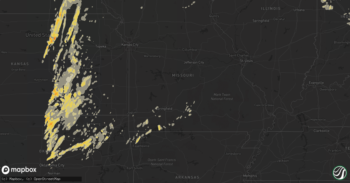
Hail Map in Nebraska on June 20, 2011
Get this storm
June 20 map
$229
one time, instant access
Download today. No call, no setup
Keep the $229
Bought the map and want the full workflow? Apply the entire $229 to a subscription within 7 days. None of it is wasted.
Every map, not just this one
This buys you this map. Subscription and you get every map we run, in the markets you choose from a few cities to whole states to nationwide. Plus real-time alerts the moment a storm fires.
Contact data
Name, contact info, occupancy, even credit band for addresses in the footprint. You go from where it hit to who to call.
Become the source they trust
Unlimited branding weather history reports on demand. You already have the documented answer ready for the property owner, and you are the one who showed up with it.
Property data and RoofTrace estimates
Pull up any address you have got, its value and the exact code rules for that jurisdiction, straight from One Click Code. Then RoofTrace estimates the squares, pitch, and roof value, priced the way you price.
Storm reports in Nebraska
Nebraska
| Date | Description |
|---|---|
| 06/20/20116:57 PM CDT | A local report indicates 1.00 inch wind near MONROE |
| 06/20/20116:49 PM CDT | A local report indicates 60 MPH wind near MONROE |
| 06/20/20116:20 PM CDT | Shed was destroyed approximately one mile north of the intersection of highways 92 and 39. |
| 06/20/20116:14 PM CDT | A local report indicates a tornado near 8 W OSCEOLA |
| 06/20/20115:59 PM CDT | Emergency management reports tornado on ground. |
| 06/20/20115:55 PM CDT | Tornado still on the ground. |
| 06/20/20115:54 PM CDT | Hail covered the ground. |
| 06/20/20115:54 PM CDT | Large multiple vortex tornado on the ground. |
| 06/20/20115:50 PM CDT | Tornado on the ground 3 to 4 miles east of hampton |
| 06/20/20115:49 PM CDT | Tornado on the ground. |
| 06/20/20115:44 PM CDT | Tornado damage 2 miles west of bradshaw. Grain bins damaged and train derailed. Power lines down as well. |
| 06/20/20115:35 PM CDT | Delayed report. Possible tornado damage at davis creek campground. Nws storm survey will investigate. Time estimated from radar. |
| 06/20/20115:34 PM CDT | A local report indicates a tornado near 2 W HAMPTON |
| 06/20/20115:34 PM CDT | A local report indicates 1.25 inch wind near 3 WSW BRADSHAW |
| 06/20/20115:33 PM CDT | A local report indicates 1.00 inch wind near 5 SSE FAIRBURY |
| 06/20/20115:26 PM CDT | Fire department reports tornado on ground 2 miles south and 1 west of hampton interstate exchange. |
| 06/20/20115:12 PM CDT | A large tree fell on a house near engleman and abbott roads on the west side of grand island. |
| 06/20/20115:06 PM CDT | Tornado on the ground just lifted. |
| 06/20/20115:00 PM CDT | Quarter size hail southwest side of grand island |
| 06/20/20114:51 PM CDT | Quarter size hail reported on the northwest part of grand island. |
| 06/20/20114:48 PM CDT | Golf ball size hail just north of interstate 80. |
| 06/20/20114:45 PM CDT | Stovepipe tornado on the ground. |
| 06/20/20114:42 PM CDT | A local report indicates 1.00 inch wind near GILTNER |
| 06/20/20114:35 PM CDT | High voltage power lines down 2 miles north of amherst. Garage is damaged and a house is destroyed. |
| 06/20/20114:35 PM CDT | Rope tornado on ground southeast of miller. |
| 06/20/20114:35 PM CDT | A local report indicates 1.00 inch wind near MILLER |
| 06/20/20114:26 PM CDT | Houses damaged and grain bins destroyed. Power lines across roadway and center pivots turned over. |
| 06/20/20114:19 PM CDT | A local report indicates 2.00 inch wind near 10 NW GIBBON |
| 06/20/20114:16 PM CDT | A local report indicates 2.75 inch wind near 10 N ELM CREEK |
| 06/20/20114:16 PM CDT | A local report indicates 1.00 inch wind near 7 NW GIBBON |
| 06/20/20114:15 PM CDT | Large tornado becoming rain wrapped. |
| 06/20/20114:11 PM CDT | Semi was overturned on highway 30. |
| 06/20/20114:00 PM CDT | Roof damaged in elm creek. |
| 06/20/20114:00 PM CDT | Roof partially removed from home on west side of elm creek. Power lines down |
| 06/20/20113:52 PM CDT | A local report indicates 1.00 inch wind near 3 WNW SUTHERLAND |
| 06/20/20113:50 PM CDT | Emergency manager reports 2 tornadoes on the ground with debris. |
| 06/20/20113:50 PM CDT | A local report indicates 60 MPH wind near 2 W OVERTON |
| 06/20/20113:50 PM CDT | A local report indicates 1.00 inch wind near 3 SW OVERTON |
| 06/20/20113:45 PM CDT | A local report indicates 1.75 inch wind near OVERTON |
| 06/20/20113:44 PM CDT | Damage to some residences and pipe lines. Pivots turned over. |
| 06/20/20113:44 PM CDT | Dime to ping pong ball size hail 2 to 3 miles southwest of overton on interstate 80. |
| 06/20/20113:32 PM CDT | Tornado lasted approximately 3 minutes. |
| 06/20/20113:28 PM CDT | Rain wrapped tornado reported by trained spotter. |
| 06/20/20113:05 PM CDT | 3 tornadoes spotted 6 miles south of stamford. |
| 06/20/20113:05 PM CDT | A local report indicates 1.50 inch wind near 6 S STAMFORD |
| 06/20/20113:03 PM CDT | A local report indicates 62 MPH wind near MCCOOK |
| 06/20/20112:15 PM CDT | A local report indicates 1.25 inch wind near 2 S BENKELMAN |
| 06/20/20119:32 AM CDT | 2-3 inch diameter tree limbs down. Pea to penny size hail. |
| 06/19/20119:00 PM CDT | Numerous trees down...both uprooted and broken. |
| 06/19/20118:50 PM CDT | A local report indicates 60 MPH wind near MURRAY |
| 06/19/20118:36 PM CDT | A local report indicates 60 MPH wind near TEKAMAH |
| 06/19/20118:35 PM CDT | Many trees down in rosalie. |
| 06/19/20118:30 PM CDT | 8 inch tree limbs down in south omaha at 45th street. Wind estimated to be 60 miles an hour plus. |
| 06/19/20118:20 PM CDT | Official observation at eppley airfield. |
| 06/19/20118:20 PM CDT | Full size trees reported down near bell street. |
| 06/19/20118:19 PM CDT | Several trees down in town and a farm building moved off its foundation northwest of town. Relayed by emergency manager. |
| 06/19/20118:17 PM CDT | Near 72 and 680. |
| 06/19/20118:17 PM CDT | Near 72 and 680. |
| 06/19/20118:05 PM CDT | Trees and electrical lines down. |
| 06/19/20118:05 PM CDT | Power out |
| 06/19/20118:03 PM CDT | Large tree blown over on highway 12. A 54 mile an hour gust at spotters house. |
| 06/19/20118:00 PM CDT | Winds at least 70 mph. Trees and power lines down...and north side of town without power. |
| 06/19/20117:59 PM CDT | A local report indicates 73 MPH wind near 1 NW VALLEY |
| 06/19/20117:58 PM CDT | Neighbors siding blown off. |
| 06/19/20117:58 PM CDT | A local report indicates 70 MPH wind near MEAD |
| 06/19/20117:55 PM CDT | 15 inch diameter trees blown over. |
| 06/19/20117:55 PM CDT | Tree down near dispatcher residence northwest of town. |
| 06/19/20117:55 PM CDT | A local report indicates 70 MPH wind near MEAD |
| 06/19/20117:50 PM CDT | Several trees down in town and a farm building moved off its foundation northwest of town. Relayed by emergency manager. Corrected time of event. |
| 06/19/20117:44 PM CDT | 2 foot diameter trees down. Winds estimated at 70 mph. |
| 06/19/20117:43 PM CDT | A local report indicates 60 MPH wind near ADAMS |
| 06/19/20117:40 PM CDT | Home north of willow lake lost roof. Estimated wind speed was 70 mph. |
| 06/19/20117:40 PM CDT | Several trees and power lines down. |
| 06/19/20117:38 PM CDT | Observation at norfolk airport. |
| 06/19/20117:38 PM CDT | A local report indicates 1.75 inch wind near 4 S MADISON |
| 06/19/20117:35 PM CDT | Farmsteads with significant outbuilding damage north and east of pierce. |
| 06/19/20117:30 PM CDT | Relayed by broadcast media. |
| 06/19/20117:30 PM CDT | Building torn apart 5 miles south of clearwater. |
| 06/19/20117:30 PM CDT | Straight line winds of 70 to 73 miles an hour. Two inches of rain fell in 30 minutes. |
| 06/19/20117:30 PM CDT | Tree debris on highway 20. Wind speed estimated 60 mph. |
| 06/19/20117:30 PM CDT | Many trees and some power lines down. Estimated wind speed was 65 mph. |
| 06/19/20117:27 PM CDT | Several trees down in norfolk. Small hail also covered the ground in some areas. |
| 06/19/20117:27 PM CDT | Emergency management reported pea to quarter size hail. |
| 06/19/20117:16 PM CDT | Observation at norfolk stefan airport. |
| 06/19/20117:13 PM CDT | A local report indicates 70 MPH wind near NW OAKDALE |
| 06/19/20117:10 PM CDT | A local report indicates 1.75 inch wind near 2 W PLATTE CENTER |
| 06/19/20117:06 PM CDT | A local report indicates 63 MPH wind near 4 S NORFOLK |
All States Impacted by Hail Map on June 20, 2011
Cities Impacted by Hail Map on June 20, 2011
- Elkader, IA
- Saint Paul, NE
- Wolbach, NE
- Wayne, NE
- Neligh, NE
- Cazenovia, WI
- Winthrop, IA
- Oxford, IN
- Boswell, IN
- Fowler, IN
- Fort Atkinson, IA
- Calmar, IA
- Castana, IA
- Soldier, IA
- Carroll, NE
- Lansing, IA
- New Richmond, IN
- Crawfordsville, IN
- McCook, NE
- Veedersburg, IN
- Attica, IN
- Gypsum, KS
- Woodbine, KS
- Chapman, KS
- Colby, KS
- Atwood, KS
- Ludell, KS
- Herndon, KS
- Dwight, KS
- White City, KS
- Junction City, KS
- Newton, KS
- Walton, KS
- Peabody, KS
- Hartford, KS
- Hamilton, KS
- Eureka, KS
- Madison, KS
- Lehigh, KS
- Canton, KS
- Frenchburg, KY
- Slade, KY
- Emporia, KS
- Reading, KS
- Hillsboro, KS
- Deerfield, KS
- Oklahoma City, OK
- Lampe, MO
- Reeds Spring, MO
- Galena, MO
- Shell Knob, MO
- Kimberling City, MO
- Pryor, OK
- Inola, OK
- Claremore, OK
- Tulsa, OK
- Southlake, TX
- Dallas, TX
- Grapevine, TX
- Vinita, OK
- Pritchett, CO
- Merkel, TX
- Ramona, OK
- Talala, OK
- Bartlesville, OK
- Campton, KY
- South Haven, KS
- Barnsdall, OK
- Coleman, TX
- Novice, TX
- Marble Rock, IA
- Greene, IA
- Max, NE
- Wichita, KS
- Hoxie, KS
- Oxford, NE
- Manilla, IN
- Dunlap, IA
- Woodbine, IA
- Riceville, IA
- Osage, IA
- Pickrell, NE
- Clatonia, NE
- Adams, NE
- Cortland, NE
- De Witt, NE
- Wilber, NE
- Beatrice, NE
- Hallam, NE
- Rock, KS
- Udall, KS
- Mulvane, KS
- Douglass, KS
- Rose Hill, KS
- Latham, KS
- Leon, KS
- Weatherford, TX
- Duncan, OK
- Tussy, OK
- Hennepin, OK
- Ratliff City, OK
- Elmore City, OK
- Sand Springs, OK
- Sperry, OK
- Mannford, OK
- Yale, OK
- Drumright, OK
- Cushing, OK
- Skiatook, OK
- Kellyville, OK
- Cleveland, OK
- Sapulpa, OK
- Jennings, OK
- Garfield, AR
- Wynnewood, OK
- Dexter, KS
- Maple City, KS
- Shidler, OK
- Arlington, TX
- Fort Worth, TX
- Naval Air Station Jrb, TX
- Lone Rock, WI
- Richland Center, WI
- Vinton, IA
- Greensburg, IN
- Saint Paul, IN
- Norfolk, NE
- Battle Creek, NE
- Riley, KS
- Olsburg, KS
- Manhattan, KS
- Sheridan Lake, CO
- Arapahoe, CO
- Elmdale, KS
- Marion, KS
- Cedar Point, KS
- Benton, KS
- Andover, KS
- Mcconnell Afb, KS
- Haysville, KS
- Clearwater, KS
- Valley Center, KS
- Conway Springs, KS
- Derby, KS
- Maize, KS
- Alda, NE
- Grand Island, NE
- Aurora, NE
- Harvard, NE
- Abilene, TX
- Loup City, NE
- Litchfield, NE
- Ravenna, NE
- Colwell, IA
- Charles City, IA
- Holton, IN
- Osgood, IN
- Abilene, KS
- Manter, KS
- Johnson, KS
- Lakin, KS
- Walsh, CO
- Ulysses, KS
- Winfield, KS
- Belle Plaine, KS
- Wellington, KS
- Lamont, OK
- Nardin, OK
- Medford, OK
- Deer Creek, OK
- Hunter, OK
- Crescent, OK
- Elba, NE
- Clifton, KS
- Bowie, TX
- Henrietta, TX
- Bellevue, TX
- Bertrand, NE
- Arkansas City, KS
- Towanda, KS
- Mount Olivet, KY
- Mayslick, KY
- Germantown, KY
- Caldwell, KS
- Henderson, NE
- Hampton, NE
- Bradshaw, NE
- Burden, KS
- Cambridge, KS
- Buffalo Gap, TX
- Ovalo, TX
- Tuscola, TX
- Waterville, KS
- Blue Rapids, KS
- Delphos, KS
- Miltonvale, KS
- Cambridge, NE
- Wilsonville, NE
- Granada, CO
- Piedmont, KS
- Chico, TX
- Flower Mound, TX
- Lewisville, TX
- Jacksboro, TX
- Windthorst, TX
- Albany, TX
- Lenora, KS
- Scott City, KS
- Graford, TX
- Perrin, TX
- Oakley, KS
- Monument, KS
- Overton, NE
- Haddam, KS
- Humphrey, NE
- Monroe, NE
- Madison, NE
- Platte Center, NE
- Newcastle, TX
- Azle, TX
- Poolville, TX
- Springtown, TX
- Morrowville, KS
- Woodson, TX
- Grinnell, KS
- Graham, TX
- Bryson, TX
- Palmer, KS
- Linn, KS
- Greenleaf, KS
- Washington, KS
- Herington, KS
- Hope, KS
- Meridian, OK
- Guthrie, OK
- Ponca City, OK
- Burbank, OK
- Genoa, NE
- Columbus, NE
- Silver Creek, NE
- Lindsay, NE
- South Bend, TX
- Breckenridge, TX
- Elm Creek, NE
- Miller, NE
- Amherst, NE
- Prairie Du Chien, WI
- Bloomington, WI
- Bagley, WI
- Cassville, WI
- Glen Haven, WI
- Garnavillo, IA
- Guttenberg, IA
- Modale, IA
- Missouri Valley, IA
- Fairbury, NE
- Endicott, NE
- Clay Center, KS
- Tescott, KS
- Swanton, NE
- Bennington, KS
- Morganville, KS
- Agenda, KS
- Steele City, NE
- Jansen, NE
- Minneapolis, KS
- Aurora, KS
- Diller, NE
- Plymouth, NE
- Mahaska, KS
- Salina, KS
- Hollenberg, KS
- Cuba, KS
- Clyde, KS
- Concordia, KS
- Lindsborg, KS
- Newkirk, OK
- Ripley, OH
- Yankton, SD
- Mission Hill, SD
- Volin, SD
- Pilot Point, TX
- Gunter, TX
- Aubrey, TX
- Decatur, TX
- Sanger, TX
- Celina, TX
- Van Alstyne, TX
- Marlow, OK
- Aplington, IA
- Ackley, IA
- Dumont, IA
- Jermyn, TX
- Agra, OK
- Perkins, OK
- Tryon, OK
- Rhome, TX
- Hendley, NE
- Arapahoe, NE
- Beaver City, NE
- Stamford, NE
- Selden, KS
- Penokee, KS
- Norton, KS
- Quinter, KS
- Almena, KS
- Hill City, KS
- Morland, KS
- Grainfield, KS
- Park, KS
- Montgomery, LA
- Colfax, LA
- Cloutierville, LA
- Elgin, NE
- Polk, NE
- Ponder, TX
- Friend, NE
- Waco, NE
- Exeter, NE
- Milligan, NE
- York, NE
- Cordova, NE
- Perry, OK
- Throckmorton, TX
- Flemingsburg, KY
- Ewing, KY
- Moorefield, KY
- Indianapolis, IN
- Clyde, TX
- Lawn, TX
- Tye, TX
- Dyess Afb, TX
- Wakefield, KS
- Leonardville, KS
- Randolph, KS
- Nashua, IA
- Waverly, IA
- Plainfield, IA
- Council Grove, KS
- Eads, CO
- Mount Sterling, KY
- Owingsville, KY
- Fall River, KS
- Eagle Rock, MO
- Eureka Springs, AR
- Olney, TX
- Palmer, IA
- Rolfe, IA
- Pocahontas, IA
- Gilmore City, IA
- Sutherland, NE
- Bridgeport, TX
- Hesston, KS
- Halstead, KS
- Moundridge, KS
- Alta Vista, KS
- Cave Springs, AR
- Gentry, AR
- Rogers, AR
- Springdale, AR
- Bentonville, AR
- Stillwater, OK
- Ida Grove, IA
- Carroll, IA
- Floyd, IA
- Westmoreland, KS
- Burns, KS
- Aledo, TX
- Flat Rock, IN
- Irving, TX
- Blackwell, OK
- Braman, OK
- Atlanta, KS
- Postville, IA
- Syracuse, KS
- Ogden, KS
- Falmouth, KY
- Brooksville, KY
- Augusta, KY
- Coolidge, KS
- Waterville, IA
- Cleghorn, IA
- Marcus, IA
- Irene, SD
- Meadow Grove, NE
- Osceola, NE
- Clarks, NE
- Hordville, NE
- Osmond, NE
- Saint Edward, NE
- Stromsburg, NE
- Pierce, NE
- Newman Grove, NE
- Tilden, NE
- Blairstown, IA
- Van Horne, IA
- Marengo, IA
- Pleasanton, NE
- Albion, NE
- Marquette, NE
- Chalmers, IN
- Axtell, KS
- Phillips, NE
- New Berlin, IL
- Pleasant Plains, IL
- Rushville, IN
- Milroy, IN
- Holcomb, KS
- Florence, KS
- Lincolnville, KS
- Cassoday, KS
- Strong City, KS
- Cottonwood Falls, KS
- Blackey, KY
- Cornettsville, KY
- Letcher, KY
- Vanzant, MO
- Drury, MO
- Lamar, CO
- Milan, KS
- Kim, CO
- Chelsea, OK
- Crane, MO
- Billings, MO
- Campo, CO
- Oxford, KS
- Tonkawa, OK
- Mulhall, OK
- Edmond, OK
- Coyle, OK
- Piedmont, OK
- Morrison, OK
- Orlando, OK
- Yukon, OK
- Bartlett, NE
- Spalding, NE
- Muscoda, WI
- Allison, IA
- Covington, OK
- Douglas, OK
- Lucien, OK
- Marshall, OK
- Mead, NE
- Paxton, NE
- Fairfax, OK
- Carney, OK
- Ripley, OK
- Wellston, OK
- Luther, OK
- Arcadia, OK
- Lexington, NE
- Smithfield, NE
- Sumner, NE
- Weskan, KS
- Sharon Springs, KS
- Wallace, KS
- Garber, OK
- Billings, OK
- Mesquite, TX
- Grenola, KS
- Haslet, TX
- Roanoke, TX
- Pond Creek, OK
- Owasso, OK
- Collinsville, OK
- Alvord, TX
- Krum, TX
- Denton, TX
- Loving, TX
- Schleswig, IA
- Charter Oak, IA
- Aurelia, IA
- Galva, IA
- Forest City, IA
- Ionia, IA
- Orchard, IA
- Doniphan, NE
- Wingate, IN
- Waynetown, IN
- Romney, IN
- Wauneta, NE
- Saronville, NE
- Bird City, KS
- Sterling, NE
- Belleville, KS
- Hillsboro, KY
- Longford, KS
- Durham, KS
- Enterprise, KS
- Purdy, MO
- Wheaton, MO
- Exeter, MO
- Rocky Comfort, MO
- Ava, MO
- Hazard, KY
- Chavies, KY
- Rowdy, KY
- Warbranch, KY
- Roark, KY
- Manchester, KY
- Essie, KY
- Terlton, OK
- Okeechobee, FL
- Balch Springs, TX
- Clearwater, NE
- Petersburg, NE
- Albert City, IA
- Fonda, IA
- Laurens, IA
- Butlerville, IN
- Farwell, NE
- Dannebrog, NE
- Rockville, NE
- Ashton, NE
- Kechi, KS
- Sedgwick, KS
- Argonia, KS
- Goodland, KS
- Cheyenne Wells, CO
- Edson, KS
- Lueders, TX
- Fremont, NE
- Arlington, NE
- Temple, OK
- Malmo, NE
- Liberty, NE
- Virginia, NE
- Wilsey, KS
- Geuda Springs, KS
- Comanche, OK
- Waurika, OK
- Argyle, TX
- Justin, TX
- Jackson, KY
- Riverdale, NE
- Kearney, NE
- Dundee, IA
- Lohrville, IA
- Lake City, IA
- Giltner, NE
- Ewing, NE
- Avoca, IA
- Indianola, NE
- Greenwood, IN
- Burdick, KS
- Beattyville, KY
- Carlisle, KY
- Cynthiana, KY
- Sharpsburg, KY
- Howard, KS
- Bradleyville, MO
- Forsyth, MO
- Fairview, MO
- Stella, MO
- Anderson, MO
- Colcord, OK
- Oologah, OK
- West Union, IA
- Scotia, NE
- Greeley, NE
- Pine Village, IN
- Brewster, KS
- Levant, KS
- Coeburn, VA
- Wise, VA
- Broken Arrow, OK
- Catoosa, OK
- Randlett, OK
- Sunnyvale, TX
- Kendall, KS
- Leoti, KS
- Marienthal, KS
- Augusta, KS
- El Dorado, KS
- Foster, KY
- Home, KS
- Marysville, KS
- Oketo, KS
- Wymore, NE
- Butterfield, MO
- Enid, OK
- Fairmont, OK
- Batesville, IN
- Gainesville, TX
- Boyd, TX
- Whitt, TX
- Mineral Wells, TX
- Menno, SD
- Freeman, SD
- Viborg, SD
- Newell, IA
- Strawberry Point, IA
- Edgewood, IA
- Masonville, IA
- Ithaca, NE
- Clarksville, IA
- North Bend, NE
- Tobias, NE
- Beaver Crossing, NE
- McCool Junction, NE
- Galveston, IN
- Hazard, NE
- Gibbon, NE
- Rexford, KS
- Otterbein, IN
- West Lafayette, IN
- Oberlin, KS
- Norcatur, KS
- Westport, IN
- Hope, KY
- Jeffersonville, KY
- Means, KY
- Chatham, VA
- Butler, KY
- Berry, KY
- Neville, OH
- Maysville, KY
- California, KY
- Moscow, OH
- Georgetown, OH
- Dover, KY
- Bethel, OH
- Felicity, OH
- Sunset, TX
- Hominy, OK
- Dewey, OK
- Copan, OK
- Keller, TX
- Honey Grove, TX
- Hastings, OK
- Pawnee, OK
- Rockford, IA
- Holliday, TX
- Castalia, IA
- Barnes, KS
- Green, KS
- Healy, KS
- Newark, TX
- Paradise, TX
- Laurel, NE
- Concord, NE
- Wakefield, NE
- Benkelman, NE
- Laurel, IN
- Longton, KS
- Stanton, KY
- Hennessey, OK
- Waukomis, OK
- Kremlin, OK
- Rockwall, TX
- Wichita Falls, TX
- Terrell, TX
- Seagoville, TX
- Boscobel, WI
- Blue River, WI
- Era, TX
- Tyndall, SD
- Tabor, SD
- Williamsport, IN
- Fort Riley, KS
- Rensselaer, IN
- Dedham, IA
- Coon Rapids, IA
- Glidden, IA
- Branson, MO
- Virgil, KS
- Potwin, KS
- Mayfield, KS
- Kaw City, OK
- Siloam Springs, AR
- Mounds, OK
- Valley View, TX
- Lake Dallas, TX
- Tioga, TX
- Rosston, TX
- Howe, TX
- Anna, TX
- Sherman, TX
- Cedar Vale, KS
- Springfield, CO
- Beaumont, KS
- Kesley, IA
- Bristow, IA
- Morse Bluff, NE
- Crete, NE
- Martell, NE
- Tecumseh, NE
- Zionsville, IN
- Whitestown, IN
- Westfield, IN
- Carmel, IN
- Frankfort, KS
- Waldron, IN
- Napoleon, IN
- Milan, IN
- Whiteland, IN
- Saint George, KS
- Wamego, KS
- Monett, MO
- Cassville, MO
- Whitewater, KS
- Loxahatchee, FL
- Ossian, IA
- Clermont, IA
- Fordyce, NE
- Utica, SD
- Saint Helena, NE
- Crofton, NE
- Barneston, NE
- Blue Springs, NE
- Gayville, SD
- Mondamin, IA
- McIntire, IA
- Toledo, IA
- Bode, IA
- Humboldt, IA
- Valley, NE
- Lincoln, NE
- North Loup, NE
- Holbrook, NE
- Greenwich, KS
- Moline, KS
- Mountain Grove, MO
- Norwood, MO
- Seligman, MO
- Mckinney, TX
- Bonham, TX
- Ector, TX
- Prue, OK
- Viroqua, WI
- New Lisbon, WI
- Mauston, WI
- Mabel, MN
- Kenyon, MN
- Decorah, IA
- Elgin, IA
- New Hampton, IA
- Alta Vista, IA
- Emmetsburg, IA
- Curlew, IA
- Geneva, IA
- Rutland, IA
- Sutherland, IA
- Irwin, IA
- Manilla, IA
- Audubon, IA
- Homer, NE
- Hubbard, NE
- Emerson, NE
- Churdan, IA
- Watkins, IA
- Newhall, IA
- Oakland, NE
- Craig, NE
- Tekamah, NE
- Norwalk, IA
- Prole, IA
- Cumming, IA
- Scribner, NE
- Prague, NE
- Cedar Bluffs, NE
- Harlan, IA
- Wahoo, NE
- Colon, NE
- Yutan, NE
- Syracuse, NE
- Wolcott, IN
- Monon, IN
- Monticello, IN
- Winterset, IA
- Shelbyville, IN
- Emmett, KS
- Saint Marys, KS
- Tampa, KS
- Alma, KS
- New Richmond, OH
- Wallingford, KY
- Tollesboro, KY
- De Mossville, KY
- Hamersville, OH
- Toronto, KS
- Zoe, KY
- Vancleve, KY
- Booneville, KY
- Rogers, KY
- Moran, KS
- McKee, KY
- Vincent, KY
- Stinnett, KY
- Hyden, KY
- Aurora, MO
- Marionville, MO
- Vilas, CO
- Elk City, KS
- Thousandsticks, KY
- Jones, OK
- Bixby, OK
- Jenks, OK
- Decatur, AR
- Cashion, OK
- Whitewright, TX
- Trenton, TX
- Caddo, TX
- Crandall, TX
- Forney, TX
- West Palm Beach, FL
- Wellington, FL
- Fort Myers, FL
- Lehigh Acres, FL
- Wisconsin Rapids, WI
- Rudolph, WI
- Norwalk, WI
- Port Edwards, WI
- Nekoosa, WI
- Manly, IA
- Mason City, IA
- Manchester, IA
- Lamont, IA
- Readlyn, IA
- Denver, IA
- Luana, IA
- Cherokee, IA
- Larrabee, IA
- Mclean, NE
- Randolph, NE
- Denison, IA
- Alta, IA
- Holstein, IA
- Moville, IA
- Lesterville, SD
- Rosalie, NE
- Macy, NE
- Decatur, NE
- Lyons, NE
- North Vernon, IN
- Sunman, IN
- Hope, IN
- Hartsville, IN
- Oldenburg, IN
- Rutledge, MO
- Baring, MO
- Memphis, MO
- Pleasantville, IA
- Belvue, KS
- Hershey, NE
- Mora, LA
- Savoy, TX
- Adair, OK
- Dodson, LA
- Jonesboro, LA
- Winona, KS
- Pound, VA
- Mayking, KY
- Elkhart, KS
- Maramec, OK
- Grand Prairie, TX
- Mansfield, TX
- Bedford, VA
- Bulan, KY
- Krypton, KY
- Lost Creek, KY
- Ary, KY
- Hartville, MO
- Mansfield, MO
- Graff, MO
- Brinson, GA
- Lost Springs, KS
- Ramona, KS
- West Concord, MN
- De Soto, WI
- Spring Grove, MN
- Peterson, MN
- Rushford, MN
- Wonewoc, WI
- Elroy, WI
- Ridgeway, IA
- Cresco, IA
- Harpers Ferry, IA
- Waukon, IA
- Le Mars, IA
- Hinton, IA
- Volga, IA
- Britt, IA
- Garner, IA
- Dodgeville, WI
- Quimby, IA
- Tripoli, IA
- Sac City, IA
- Lake View, IA
- Ericson, NE
- Independence, IA
- Battle Creek, IA
- Clare, IA
- Garwin, IA
- Vail, IA
- Clutier, IA
- Traer, IA
- Tama, IA
- State Center, IA
- Kimballton, IA
- Kirkman, IA
- Van Meter, IA
- Mason City, NE
- Walnut, IA
- Omaha, NE
- Bennington, NE
- Clearfield, IA
- Red Oak, IA
- Clay Center, NE
- Brookston, IN
- Earl Park, IN
- Battle Ground, IN
- Lafayette, IN
- Brashear, MO
- Kirksville, MO
- Pawnee City, NE
- Steinauer, NE
- Vermillion, KS
- Baileyville, KS
- Beattie, KS
- Summerfield, KS
- Rossville, KS
- Americus, KS
- Sabetha, KS
- Sedan, KS
- Irvine, KY
- Plato, MO
- Bucyrus, MO
- Chanute, KS
- Ash Grove, MO
- Bois D Arc, MO
- Republic, MO
- Galesburg, KS
- Thayer, KS
- Mozelle, KY
- Clever, MO
- Nowata, OK
- Chautauqua, KS
- Peru, KS
- Hollister, MO
- Beggs, OK
- Bells, TX
- Goldsboro, TX
- Baird, TX
- Downsville, LA
- Houston, MN
- Blair, WI
- Whitehall, WI
- Dunnell, MN
- Rudd, IA
- Elma, IA
- Woden, IA
- Buffalo Center, IA
- Titonka, IA
- Hampton, IA
- Lancaster, WI
- Mount Hope, WI
- Marquette, IA
- McGregor, IA
- Mount Auburn, IA
- Breda, IA
- Dixon, NE
- Belden, NE
- Moorhead, IA
- Runnells, IA
- Mitchellville, IA
- Hickman, NE
- Hebron, NE
- Gove, KS
- Hiawatha, KS
- Whitesburg, KY
- Gridley, KS
- Burlington, KS
- Slemp, KY
- Eolia, KY
- Mount Vernon, MO
- Centerton, AR
- Gravette, AR
- Hiwasse, AR
- Bella Vista, AR
- Taneyville, MO
- Blue Ridge, TX
- Quinlan, TX
- Lime Springs, IA
- Waucoma, IA
- Fennimore, WI
- Woodman, WI
- Highland, WI
- Avoca, WI
- Montfort, WI
- Hillsboro, WI
- Primghar, IA
- Paullina, IA
- Dougherty, IA
- Havelock, IA
- Algona, IA
- Livermore, IA
- Lu Verne, IA
- Sumner, IA
- Alexander, IA
- Meservey, IA
- Arlington, IA
- Duncombe, IA
- Colo, IA
- Nevada, IA
- Gladbrook, IA
- Beaman, IA
- Grundy Center, IA
- Reinbeck, IA
- Walthill, NE
- Pender, NE
- West Point, NE
- Hooper, NE
- Nickerson, NE
- Herman, NE
- Adel, IA
- Ashland, NE
- Waverly, NE
- Ceresco, NE
- Greenwood, NE
- Fort Calhoun, NE
- Ames, NE
- Griswold, IA
- Humboldt, NE
- Ohiowa, NE
- Tribune, KS
- Matfield Green, KS
- Admire, KS
- Allen, KS
- Independence, KS
- Hallie, KY
- Roxana, KY
- Bristow, OK
- Bluejacket, OK
- Welch, OK
- Spring Green, WI
- Lawler, IA
- Fredericksburg, IA
- Shelby, IA
- Panama, IA
- Friendship, WI
- Farnhamville, IA
- Royal, NE
- Orchard, NE
- Brunswick, NE
- Dow City, IA
- Redfield, IA
- Emmons, MN
- Lake Mills, IA
- Hixton, WI
- Washta, IA
- Pierson, IA
- Correctionville, IA
- Montour, IA
- Marshalltown, IA
- North Prairie, WI
- Waukesha, WI
- Meriden, IA
- Somers, IA
- Callender, IA
- Gowrie, IA
- Sutton, NE
- Trumbull, NE
- Roca, NE
- Solomon, KS
- Seneca, KS
- Hull, IL
- Tyner, KY
- Holly, CO
- Pine Ridge, KY
- Clay City, KY
- Wellington, KY
- Ravenna, KY
- Bartlett, KS
- Edna, KS
- Caney, KS
- Olpe, KS
- Powell, MO
- Pawhuska, OK
- Gordon, KY
- Cumberland, KY
- Ochelata, OK
- Wynona, OK
- Castle, OK
- Okemah, OK
- Sumner, TX
- Collinsville, TX
- Forestburg, TX
- North Richland Hills, TX
- Colleyville, TX
- Millsap, TX
- Little Elm, TX
- Hurst, TX
- Haltom City, TX
- Coppell, TX
- Euless, TX
- Plano, TX
- The Colony, TX
- Frisco, TX
- Winnfield, LA
- Carrollton, TX
- Loomis, NE
- Keystone, IA
- Garrison, IA
- La Valle, WI
- Hartington, NE
- New Albin, IA
- Narka, KS
- Niotaze, KS
- Goodell, IA
- Las Animas, CO
- Hillpoint, WI
- Wann, OK
- Winters, TX
- Ferryville, WI
- Arena, WI
- Lebanon, IN
- Denton, NE
- Jackson, NE
- Dakota City, NE
- Lenox, IA
- Prescott, IA
- Ashland, IL
- Alexander, IL
- Talpa, TX
- Francesville, IN
- Medaryville, IN
- Ranger, TX
- Ricetown, KY
- Worthington, MN
- Wynot, NE
- Marathon, IA
- Bancroft, NE
- Palo Pinto, TX
- Walton, IN
- Elk Falls, KS
- Parkersburg, IA
- Delphi, IN
- North Fort Myers, FL
- Covington, IN
- Newtown, IN
- Westpoint, IN
- Hillsboro, IN
- Mellott, IN
- Chester, IA
- Le Roy, MN
- Hawkeye, IA
- Round Lake, MN
- Fountain City, WI
- Rockwell, IA
- Sioux City, IA
- Elkport, IA
- Garber, IA
- Colesburg, IA
- Greeley, IA
- Lawton, IA
- Wellsburg, IA
- Austinville, IA
- Walker, IA
- Rowley, IA
- Center Point, IA
- Urbana, IA
- Central City, NE
- Winnebago, NE
- Kennard, NE
- Belgrade, NE
- West Des Moines, IA
- Waukee, IA
- Booneville, IA
- Brook, IN
- Remington, IN
- Red Rock, OK
- Ralston, OK
- Elbing, KS
- Western, NE
- Marland, OK
- Odell, NE
- Filley, NE
- Lewiston, NE
- Severy, KS
- Brookville, KS
- Peck, KS
- Crab Orchard, NE
- Burchard, NE
- Rosalia, KS
- Bethany, MO
- McFall, MO
- Plainfield, IN
- Franklin, IN
- West Newton, IN
- Cicero, IN
- Beech Grove, IN
- Camby, IN
- Avon, IN
- Boggstown, IN
- Needham, IN
- Fairland, IN
- Sheridan, IN
- Bargersville, IN
- Brownsburg, IN
- Yates Center, KS
- Viper, KY
- Tyro, KS
- Bledsoe, KY
- Chappell, KY
- Dryden, VA
- Big Stone Gap, VA
- Jay, OK
- Fayetteville, AR
- Pineville, MO
- Okmulgee, OK
- Zwolle, LA
- Many, LA
- Duffield, VA
- Pennington Gap, VA
- Blue Eye, MO
- Royse City, TX
- Eucha, OK
- Vernon, AL
- Duncanville, TX
- Sparta, WI
- Lake Park, IA
- Lakefield, MN
- Sauk City, WI
- Adams, WI
- Rockwell City, IA
- Aurora, IA
- Fayette, IA
- Hazleton, IA
- Thurston, NE
- Hudson, IA
- Cedar Falls, IA
- Manson, IA
- Fort Dodge, IA
- Primrose, NE
- Cedar Rapids, NE
- Onawa, IA
- Jefferson, IA
- Scranton, IA
- Urbandale, IA
- Grimes, IA
- Belle Plaine, IA
- Boelus, NE
- Cairo, NE
- Blair, NE
- Otoe, NE
- Benedict, NE
- Ambia, IN
- Kokomo, IN
- Falun, KS
- Marquette, KS
- Neosho, MO
- Joplin, MO
- Delaware, OK
- Arthur City, TX
- Osage, OK
- Kiefer, OK
- Cisco, TX
- Kaufman, TX
- Lena, LA
- Provencal, LA
- Welsh, LA
- Kinder, LA
- Hawley, TX
- Alma Center, WI
- Merrillan, WI
- Black River Falls, WI
- Taylor, WI
- Clear Lake, IA
- Ventura, IA
- Boyd, WI
- Mineral Point, WI
- Oelwein, IA
- Hornick, IA
- Rodney, IA
- Smithland, IA
- Lytton, IA
- Jolley, IA
- Shellsburg, IA
- Luzerne, IA
- Portsmouth, IA
- Victor, IA
- Ladora, IA
- Haverhill, IA
- Laurel, IA
- Winamac, IN
- Bunker Hill, IN
- Amboy, IN
- Hurdland, MO
- Moores Hill, IN
- Paris, KY
- Independence, KY
- Newport, KY
- Alexandria, KY
- Latonia, KY
- Goessel, KS
- Keeling, VA
- Java, VA
- Watts, OK
- Glenpool, OK
- Choudrant, LA


