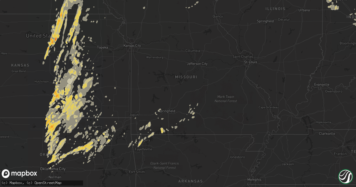
Hail Map in Texas on June 20, 2011
Get this storm
June 20 map
$229
one time, instant access
Download today. No call, no setup
Keep the $229
Bought the map and want the full workflow? Apply the entire $229 to a subscription within 7 days. None of it is wasted.
Every map, not just this one
This buys you this map. Subscription and you get every map we run, in the markets you choose from a few cities to whole states to nationwide. Plus real-time alerts the moment a storm fires.
Contact data
Name, contact info, occupancy, even credit band for addresses in the footprint. You go from where it hit to who to call.
Become the source they trust
Unlimited branding weather history reports on demand. You already have the documented answer ready for the property owner, and you are the one who showed up with it.
Property data and RoofTrace estimates
Pull up any address you have got, its value and the exact code rules for that jurisdiction, straight from One Click Code. Then RoofTrace estimates the squares, pitch, and roof value, priced the way you price.
Storm reports in Texas
Texas
| Date | Description |
|---|---|
| 06/20/20116:48 PM CDT | Near 578 and 179 |
| 06/20/20116:31 PM CDT | Between olney and loving on 114 |
| 06/20/20116:22 PM CDT | A local report indicates 1.50 inch wind near 3 SE OLNEY |
| 06/20/20116:20 PM CDT | Received a call from an idividual 2n of woodson. They reported tennis ball size hail covering the ground. |
| 06/20/20115:30 PM CDT | Called a local gas station... Proprietor reported golfball size hail covering the ground. |
| 06/20/20115:05 AM CDT | Limb fell and damaged power line. |
| 06/20/20114:45 AM CDT | Trees down |
| 06/20/20113:36 AM CDT | At loop 12 and i-35 e northwest of love field |
| 06/20/20113:09 AM CDT | A local report indicates 67 MPH wind near FRISCO |
| 06/20/20113:03 AM CDT | At fm 407 and i35e |
| 06/20/20113:00 AM CDT | 6-10 inch diameter branches were snapped off trees in hebron and carrolton |
| 06/20/20112:56 AM CDT | Large limbs down |
| 06/20/20112:54 AM CDT | A local report indicates 65 MPH wind near 2 SE HIGHLAND VILLAGE |
| 06/20/20112:46 AM CDT | 2 to 3 foot diamter tree was uprooted and shingles have been torn off of roofs |
| 06/20/20112:45 AM CDT | A local report indicates 1.50 inch wind near FLOWER MOUND |
| 06/20/20112:45 AM CDT | A local report indicates 60 MPH wind near CORINTH |
| 06/20/20112:42 AM CDT | A local report indicates 1.50 inch wind near 2 S DENTON |
| 06/20/20112:35 AM CDT | Peak wind measured by asos at kdto. |
| 06/20/20112:35 AM CDT | 2-3 10 inch diameter oak trees were snapped just above the ground. |
| 06/20/20112:34 AM CDT | Kdto |
| 06/20/20112:32 AM CDT | A local report indicates 1.00 inch wind near 4 E HASLET |
| 06/20/20112:30 AM CDT | A local report indicates 1.00 inch wind near 2 SW DENTON |
| 06/20/20112:30 AM CDT | Hail; a trees and tree limbs down; fences knocked over; minor street flooding |
| 06/20/20112:26 AM CDT | Significant damage from tree blown into residence |
| 06/20/20112:21 AM CDT | 7 miles west of highway 114/fm156 intersection |
| 06/20/20112:18 AM CDT | Estimated 55 to 60 mph 11 miles west of denton on hwy 380. |
| 06/20/20112:18 AM CDT | Roof collapse at lodge condominiums |
| 06/20/20112:12 AM CDT | Power out as well |
| 06/20/20112:04 AM CDT | Sustained for several minutes |
| 06/20/20111:45 AM CDT | *** 1 inj *** roof collapse to the sunset inn. 1 person was transported to a hospital after sustaining an injury. |
| 06/20/20111:41 AM CDT | Klud |
| 06/20/20111:40 AM CDT | A local report indicates 74 MPH wind near BRIDGEPORT |
| 06/20/201112:27 AM CDT | View fire chief reported several power poles down and a metal roof blown off of residence. He also said that bufallo gap also had power poles down. |
| 06/20/201112:22 AM CDT | From dyess observation at 1210 am cdt. |
| 06/20/201112:20 AM CDT | Satellite dishes were damaged by thunderstorm winds at kean radio. |
| 06/20/201112:12 AM CDT | 78 mph wind gust measured by dyess afb awos at 1212 am. |
| 06/19/201111:33 PM CDT | A local report indicates 1.00 inch wind near 2 SW JUSTIN |
| 06/19/201111:30 PM CDT | Fences down; tree 1 ft diameter broekn; several 8-10 inch trees uprooted |
| 06/19/201111:27 PM CDT | A local report indicates 1.00 inch wind near HASLET |
| 06/19/201111:21 PM CDT | A local report indicates 62 MPH wind near 2 E TIOGA |
| 06/19/201111:21 PM CDT | A local report indicates 2.00 inch wind near 5 N AZLE |
| 06/19/201111:18 PM CDT | Auto body roof blown off onto 377 near pilot point |
| 06/19/201111:12 PM CDT | A local report indicates 1.75 inch wind near 3 E SPRINGTOWN |
| 06/19/201110:59 PM CDT | Cracked the window on a car and dented the hood of the car. |
| 06/19/201110:32 PM CDT | On hwy 380 |
| 06/19/201110:10 PM CDT | Estimated 55-70 mph winds |
| 06/19/201110:10 PM CDT | Estimated quarter to golf ball sized hail |
| 06/19/20119:58 PM CDT | Reported roof/structural damage |
| 06/19/20119:40 PM CDT | A local report indicates 60 MPH wind near VALLEY VIEW |
| 06/19/20119:12 PM CDT | A local report indicates 2.75 inch wind near GRAFORD |
| 06/19/20118:46 PM CDT | Reported by 2 spotters |
| 06/19/20118:40 PM CDT | A local report indicates 1.25 inch wind near BRIDGEPORT |
| 06/19/20118:35 PM CDT | A local report indicates 1.75 inch wind near RUNAWAY BAY |
| 06/19/20118:35 PM CDT | A local report indicates 1.75 inch wind near CHICO |
| 06/19/20118:29 PM CDT | A local report indicates 1.75 inch wind near LOVING |
| 06/19/20118:25 PM CDT | Ping pong and golfball size hail covering ground |
| 06/19/20118:05 PM CDT | A local report indicates 60 MPH wind near OLNEY |
| 06/19/20117:40 PM CDT | A local report indicates 2.75 inch wind near 5 S BRYSON |
| 06/19/20117:36 PM CDT | A local report indicates 1.00 inch wind near BRYSON |
| 06/19/20117:31 PM CDT | Golfball size hail fell for at least 5 minutes in bryson. |
| 06/19/20117:30 PM CDT | Reported roof blown off an attached garage and downed powerlines |
| 06/19/20117:26 PM CDT | Newcastle |
| 06/19/20117:22 PM CDT | A local report indicates 2.50 inch wind near 2 E GRAHAM |
| 06/19/20117:20 PM CDT | A local report indicates 1.00 inch wind near GRAHAM |
| 06/19/20117:18 PM CDT | In graham |
| 06/19/20117:13 PM CDT | Graham |
| 06/19/20117:00 PM CDT | A local report indicates 1.75 inch wind near ANTELOPE |
All States Impacted by Hail Map on June 20, 2011
Cities Impacted by Hail Map on June 20, 2011
- Elkader, IA
- Saint Paul, NE
- Wolbach, NE
- Wayne, NE
- Neligh, NE
- Cazenovia, WI
- Winthrop, IA
- Oxford, IN
- Boswell, IN
- Fowler, IN
- Fort Atkinson, IA
- Calmar, IA
- Castana, IA
- Soldier, IA
- Carroll, NE
- Lansing, IA
- New Richmond, IN
- Crawfordsville, IN
- McCook, NE
- Veedersburg, IN
- Attica, IN
- Gypsum, KS
- Woodbine, KS
- Chapman, KS
- Colby, KS
- Atwood, KS
- Ludell, KS
- Herndon, KS
- Dwight, KS
- White City, KS
- Junction City, KS
- Newton, KS
- Walton, KS
- Peabody, KS
- Hartford, KS
- Hamilton, KS
- Eureka, KS
- Madison, KS
- Lehigh, KS
- Canton, KS
- Frenchburg, KY
- Slade, KY
- Emporia, KS
- Reading, KS
- Hillsboro, KS
- Deerfield, KS
- Oklahoma City, OK
- Lampe, MO
- Reeds Spring, MO
- Galena, MO
- Shell Knob, MO
- Kimberling City, MO
- Pryor, OK
- Inola, OK
- Claremore, OK
- Tulsa, OK
- Southlake, TX
- Dallas, TX
- Grapevine, TX
- Vinita, OK
- Pritchett, CO
- Merkel, TX
- Ramona, OK
- Talala, OK
- Bartlesville, OK
- Campton, KY
- South Haven, KS
- Barnsdall, OK
- Coleman, TX
- Novice, TX
- Marble Rock, IA
- Greene, IA
- Max, NE
- Wichita, KS
- Hoxie, KS
- Oxford, NE
- Manilla, IN
- Dunlap, IA
- Woodbine, IA
- Riceville, IA
- Osage, IA
- Pickrell, NE
- Clatonia, NE
- Adams, NE
- Cortland, NE
- De Witt, NE
- Wilber, NE
- Beatrice, NE
- Hallam, NE
- Rock, KS
- Udall, KS
- Mulvane, KS
- Douglass, KS
- Rose Hill, KS
- Latham, KS
- Leon, KS
- Weatherford, TX
- Duncan, OK
- Tussy, OK
- Hennepin, OK
- Ratliff City, OK
- Elmore City, OK
- Sand Springs, OK
- Sperry, OK
- Mannford, OK
- Yale, OK
- Drumright, OK
- Cushing, OK
- Skiatook, OK
- Kellyville, OK
- Cleveland, OK
- Sapulpa, OK
- Jennings, OK
- Garfield, AR
- Wynnewood, OK
- Dexter, KS
- Maple City, KS
- Shidler, OK
- Arlington, TX
- Fort Worth, TX
- Naval Air Station Jrb, TX
- Lone Rock, WI
- Richland Center, WI
- Vinton, IA
- Greensburg, IN
- Saint Paul, IN
- Norfolk, NE
- Battle Creek, NE
- Riley, KS
- Olsburg, KS
- Manhattan, KS
- Sheridan Lake, CO
- Arapahoe, CO
- Elmdale, KS
- Marion, KS
- Cedar Point, KS
- Benton, KS
- Andover, KS
- Mcconnell Afb, KS
- Haysville, KS
- Clearwater, KS
- Valley Center, KS
- Conway Springs, KS
- Derby, KS
- Maize, KS
- Alda, NE
- Grand Island, NE
- Aurora, NE
- Harvard, NE
- Abilene, TX
- Loup City, NE
- Litchfield, NE
- Ravenna, NE
- Colwell, IA
- Charles City, IA
- Holton, IN
- Osgood, IN
- Abilene, KS
- Manter, KS
- Johnson, KS
- Lakin, KS
- Walsh, CO
- Ulysses, KS
- Winfield, KS
- Belle Plaine, KS
- Wellington, KS
- Lamont, OK
- Nardin, OK
- Medford, OK
- Deer Creek, OK
- Hunter, OK
- Crescent, OK
- Elba, NE
- Clifton, KS
- Bowie, TX
- Henrietta, TX
- Bellevue, TX
- Bertrand, NE
- Arkansas City, KS
- Towanda, KS
- Mount Olivet, KY
- Mayslick, KY
- Germantown, KY
- Caldwell, KS
- Henderson, NE
- Hampton, NE
- Bradshaw, NE
- Burden, KS
- Cambridge, KS
- Buffalo Gap, TX
- Ovalo, TX
- Tuscola, TX
- Waterville, KS
- Blue Rapids, KS
- Delphos, KS
- Miltonvale, KS
- Cambridge, NE
- Wilsonville, NE
- Granada, CO
- Piedmont, KS
- Chico, TX
- Flower Mound, TX
- Lewisville, TX
- Jacksboro, TX
- Windthorst, TX
- Albany, TX
- Lenora, KS
- Scott City, KS
- Graford, TX
- Perrin, TX
- Oakley, KS
- Monument, KS
- Overton, NE
- Haddam, KS
- Humphrey, NE
- Monroe, NE
- Madison, NE
- Platte Center, NE
- Newcastle, TX
- Azle, TX
- Poolville, TX
- Springtown, TX
- Morrowville, KS
- Woodson, TX
- Grinnell, KS
- Graham, TX
- Bryson, TX
- Palmer, KS
- Linn, KS
- Greenleaf, KS
- Washington, KS
- Herington, KS
- Hope, KS
- Meridian, OK
- Guthrie, OK
- Ponca City, OK
- Burbank, OK
- Genoa, NE
- Columbus, NE
- Silver Creek, NE
- Lindsay, NE
- South Bend, TX
- Breckenridge, TX
- Elm Creek, NE
- Miller, NE
- Amherst, NE
- Prairie Du Chien, WI
- Bloomington, WI
- Bagley, WI
- Cassville, WI
- Glen Haven, WI
- Garnavillo, IA
- Guttenberg, IA
- Modale, IA
- Missouri Valley, IA
- Fairbury, NE
- Endicott, NE
- Clay Center, KS
- Tescott, KS
- Swanton, NE
- Bennington, KS
- Morganville, KS
- Agenda, KS
- Steele City, NE
- Jansen, NE
- Minneapolis, KS
- Aurora, KS
- Diller, NE
- Plymouth, NE
- Mahaska, KS
- Salina, KS
- Hollenberg, KS
- Cuba, KS
- Clyde, KS
- Concordia, KS
- Lindsborg, KS
- Newkirk, OK
- Ripley, OH
- Yankton, SD
- Mission Hill, SD
- Volin, SD
- Pilot Point, TX
- Gunter, TX
- Aubrey, TX
- Decatur, TX
- Sanger, TX
- Celina, TX
- Van Alstyne, TX
- Marlow, OK
- Aplington, IA
- Ackley, IA
- Dumont, IA
- Jermyn, TX
- Agra, OK
- Perkins, OK
- Tryon, OK
- Rhome, TX
- Hendley, NE
- Arapahoe, NE
- Beaver City, NE
- Stamford, NE
- Selden, KS
- Penokee, KS
- Norton, KS
- Quinter, KS
- Almena, KS
- Hill City, KS
- Morland, KS
- Grainfield, KS
- Park, KS
- Montgomery, LA
- Colfax, LA
- Cloutierville, LA
- Elgin, NE
- Polk, NE
- Ponder, TX
- Friend, NE
- Waco, NE
- Exeter, NE
- Milligan, NE
- York, NE
- Cordova, NE
- Perry, OK
- Throckmorton, TX
- Flemingsburg, KY
- Ewing, KY
- Moorefield, KY
- Indianapolis, IN
- Clyde, TX
- Lawn, TX
- Tye, TX
- Dyess Afb, TX
- Wakefield, KS
- Leonardville, KS
- Randolph, KS
- Nashua, IA
- Waverly, IA
- Plainfield, IA
- Council Grove, KS
- Eads, CO
- Mount Sterling, KY
- Owingsville, KY
- Fall River, KS
- Eagle Rock, MO
- Eureka Springs, AR
- Olney, TX
- Palmer, IA
- Rolfe, IA
- Pocahontas, IA
- Gilmore City, IA
- Sutherland, NE
- Bridgeport, TX
- Hesston, KS
- Halstead, KS
- Moundridge, KS
- Alta Vista, KS
- Cave Springs, AR
- Gentry, AR
- Rogers, AR
- Springdale, AR
- Bentonville, AR
- Stillwater, OK
- Ida Grove, IA
- Carroll, IA
- Floyd, IA
- Westmoreland, KS
- Burns, KS
- Aledo, TX
- Flat Rock, IN
- Irving, TX
- Blackwell, OK
- Braman, OK
- Atlanta, KS
- Postville, IA
- Syracuse, KS
- Ogden, KS
- Falmouth, KY
- Brooksville, KY
- Augusta, KY
- Coolidge, KS
- Waterville, IA
- Cleghorn, IA
- Marcus, IA
- Irene, SD
- Meadow Grove, NE
- Osceola, NE
- Clarks, NE
- Hordville, NE
- Osmond, NE
- Saint Edward, NE
- Stromsburg, NE
- Pierce, NE
- Newman Grove, NE
- Tilden, NE
- Blairstown, IA
- Van Horne, IA
- Marengo, IA
- Pleasanton, NE
- Albion, NE
- Marquette, NE
- Chalmers, IN
- Axtell, KS
- Phillips, NE
- New Berlin, IL
- Pleasant Plains, IL
- Rushville, IN
- Milroy, IN
- Holcomb, KS
- Florence, KS
- Lincolnville, KS
- Cassoday, KS
- Strong City, KS
- Cottonwood Falls, KS
- Blackey, KY
- Cornettsville, KY
- Letcher, KY
- Vanzant, MO
- Drury, MO
- Lamar, CO
- Milan, KS
- Kim, CO
- Chelsea, OK
- Crane, MO
- Billings, MO
- Campo, CO
- Oxford, KS
- Tonkawa, OK
- Mulhall, OK
- Edmond, OK
- Coyle, OK
- Piedmont, OK
- Morrison, OK
- Orlando, OK
- Yukon, OK
- Bartlett, NE
- Spalding, NE
- Muscoda, WI
- Allison, IA
- Covington, OK
- Douglas, OK
- Lucien, OK
- Marshall, OK
- Mead, NE
- Paxton, NE
- Fairfax, OK
- Carney, OK
- Ripley, OK
- Wellston, OK
- Luther, OK
- Arcadia, OK
- Lexington, NE
- Smithfield, NE
- Sumner, NE
- Weskan, KS
- Sharon Springs, KS
- Wallace, KS
- Garber, OK
- Billings, OK
- Mesquite, TX
- Grenola, KS
- Haslet, TX
- Roanoke, TX
- Pond Creek, OK
- Owasso, OK
- Collinsville, OK
- Alvord, TX
- Krum, TX
- Denton, TX
- Loving, TX
- Schleswig, IA
- Charter Oak, IA
- Aurelia, IA
- Galva, IA
- Forest City, IA
- Ionia, IA
- Orchard, IA
- Doniphan, NE
- Wingate, IN
- Waynetown, IN
- Romney, IN
- Wauneta, NE
- Saronville, NE
- Bird City, KS
- Sterling, NE
- Belleville, KS
- Hillsboro, KY
- Longford, KS
- Durham, KS
- Enterprise, KS
- Purdy, MO
- Wheaton, MO
- Exeter, MO
- Rocky Comfort, MO
- Ava, MO
- Hazard, KY
- Chavies, KY
- Rowdy, KY
- Warbranch, KY
- Roark, KY
- Manchester, KY
- Essie, KY
- Terlton, OK
- Okeechobee, FL
- Balch Springs, TX
- Clearwater, NE
- Petersburg, NE
- Albert City, IA
- Fonda, IA
- Laurens, IA
- Butlerville, IN
- Farwell, NE
- Dannebrog, NE
- Rockville, NE
- Ashton, NE
- Kechi, KS
- Sedgwick, KS
- Argonia, KS
- Goodland, KS
- Cheyenne Wells, CO
- Edson, KS
- Lueders, TX
- Fremont, NE
- Arlington, NE
- Temple, OK
- Malmo, NE
- Liberty, NE
- Virginia, NE
- Wilsey, KS
- Geuda Springs, KS
- Comanche, OK
- Waurika, OK
- Argyle, TX
- Justin, TX
- Jackson, KY
- Riverdale, NE
- Kearney, NE
- Dundee, IA
- Lohrville, IA
- Lake City, IA
- Giltner, NE
- Ewing, NE
- Avoca, IA
- Indianola, NE
- Greenwood, IN
- Burdick, KS
- Beattyville, KY
- Carlisle, KY
- Cynthiana, KY
- Sharpsburg, KY
- Howard, KS
- Bradleyville, MO
- Forsyth, MO
- Fairview, MO
- Stella, MO
- Anderson, MO
- Colcord, OK
- Oologah, OK
- West Union, IA
- Scotia, NE
- Greeley, NE
- Pine Village, IN
- Brewster, KS
- Levant, KS
- Coeburn, VA
- Wise, VA
- Broken Arrow, OK
- Catoosa, OK
- Randlett, OK
- Sunnyvale, TX
- Kendall, KS
- Leoti, KS
- Marienthal, KS
- Augusta, KS
- El Dorado, KS
- Foster, KY
- Home, KS
- Marysville, KS
- Oketo, KS
- Wymore, NE
- Butterfield, MO
- Enid, OK
- Fairmont, OK
- Batesville, IN
- Gainesville, TX
- Boyd, TX
- Whitt, TX
- Mineral Wells, TX
- Menno, SD
- Freeman, SD
- Viborg, SD
- Newell, IA
- Strawberry Point, IA
- Edgewood, IA
- Masonville, IA
- Ithaca, NE
- Clarksville, IA
- North Bend, NE
- Tobias, NE
- Beaver Crossing, NE
- McCool Junction, NE
- Galveston, IN
- Hazard, NE
- Gibbon, NE
- Rexford, KS
- Otterbein, IN
- West Lafayette, IN
- Oberlin, KS
- Norcatur, KS
- Westport, IN
- Hope, KY
- Jeffersonville, KY
- Means, KY
- Chatham, VA
- Butler, KY
- Berry, KY
- Neville, OH
- Maysville, KY
- California, KY
- Moscow, OH
- Georgetown, OH
- Dover, KY
- Bethel, OH
- Felicity, OH
- Sunset, TX
- Hominy, OK
- Dewey, OK
- Copan, OK
- Keller, TX
- Honey Grove, TX
- Hastings, OK
- Pawnee, OK
- Rockford, IA
- Holliday, TX
- Castalia, IA
- Barnes, KS
- Green, KS
- Healy, KS
- Newark, TX
- Paradise, TX
- Laurel, NE
- Concord, NE
- Wakefield, NE
- Benkelman, NE
- Laurel, IN
- Longton, KS
- Stanton, KY
- Hennessey, OK
- Waukomis, OK
- Kremlin, OK
- Rockwall, TX
- Wichita Falls, TX
- Terrell, TX
- Seagoville, TX
- Boscobel, WI
- Blue River, WI
- Era, TX
- Tyndall, SD
- Tabor, SD
- Williamsport, IN
- Fort Riley, KS
- Rensselaer, IN
- Dedham, IA
- Coon Rapids, IA
- Glidden, IA
- Branson, MO
- Virgil, KS
- Potwin, KS
- Mayfield, KS
- Kaw City, OK
- Siloam Springs, AR
- Mounds, OK
- Valley View, TX
- Lake Dallas, TX
- Tioga, TX
- Rosston, TX
- Howe, TX
- Anna, TX
- Sherman, TX
- Cedar Vale, KS
- Springfield, CO
- Beaumont, KS
- Kesley, IA
- Bristow, IA
- Morse Bluff, NE
- Crete, NE
- Martell, NE
- Tecumseh, NE
- Zionsville, IN
- Whitestown, IN
- Westfield, IN
- Carmel, IN
- Frankfort, KS
- Waldron, IN
- Napoleon, IN
- Milan, IN
- Whiteland, IN
- Saint George, KS
- Wamego, KS
- Monett, MO
- Cassville, MO
- Whitewater, KS
- Loxahatchee, FL
- Ossian, IA
- Clermont, IA
- Fordyce, NE
- Utica, SD
- Saint Helena, NE
- Crofton, NE
- Barneston, NE
- Blue Springs, NE
- Gayville, SD
- Mondamin, IA
- McIntire, IA
- Toledo, IA
- Bode, IA
- Humboldt, IA
- Valley, NE
- Lincoln, NE
- North Loup, NE
- Holbrook, NE
- Greenwich, KS
- Moline, KS
- Mountain Grove, MO
- Norwood, MO
- Seligman, MO
- Mckinney, TX
- Bonham, TX
- Ector, TX
- Prue, OK
- Viroqua, WI
- New Lisbon, WI
- Mauston, WI
- Mabel, MN
- Kenyon, MN
- Decorah, IA
- Elgin, IA
- New Hampton, IA
- Alta Vista, IA
- Emmetsburg, IA
- Curlew, IA
- Geneva, IA
- Rutland, IA
- Sutherland, IA
- Irwin, IA
- Manilla, IA
- Audubon, IA
- Homer, NE
- Hubbard, NE
- Emerson, NE
- Churdan, IA
- Watkins, IA
- Newhall, IA
- Oakland, NE
- Craig, NE
- Tekamah, NE
- Norwalk, IA
- Prole, IA
- Cumming, IA
- Scribner, NE
- Prague, NE
- Cedar Bluffs, NE
- Harlan, IA
- Wahoo, NE
- Colon, NE
- Yutan, NE
- Syracuse, NE
- Wolcott, IN
- Monon, IN
- Monticello, IN
- Winterset, IA
- Shelbyville, IN
- Emmett, KS
- Saint Marys, KS
- Tampa, KS
- Alma, KS
- New Richmond, OH
- Wallingford, KY
- Tollesboro, KY
- De Mossville, KY
- Hamersville, OH
- Toronto, KS
- Zoe, KY
- Vancleve, KY
- Booneville, KY
- Rogers, KY
- Moran, KS
- McKee, KY
- Vincent, KY
- Stinnett, KY
- Hyden, KY
- Aurora, MO
- Marionville, MO
- Vilas, CO
- Elk City, KS
- Thousandsticks, KY
- Jones, OK
- Bixby, OK
- Jenks, OK
- Decatur, AR
- Cashion, OK
- Whitewright, TX
- Trenton, TX
- Caddo, TX
- Crandall, TX
- Forney, TX
- West Palm Beach, FL
- Wellington, FL
- Fort Myers, FL
- Lehigh Acres, FL
- Wisconsin Rapids, WI
- Rudolph, WI
- Norwalk, WI
- Port Edwards, WI
- Nekoosa, WI
- Manly, IA
- Mason City, IA
- Manchester, IA
- Lamont, IA
- Readlyn, IA
- Denver, IA
- Luana, IA
- Cherokee, IA
- Larrabee, IA
- Mclean, NE
- Randolph, NE
- Denison, IA
- Alta, IA
- Holstein, IA
- Moville, IA
- Lesterville, SD
- Rosalie, NE
- Macy, NE
- Decatur, NE
- Lyons, NE
- North Vernon, IN
- Sunman, IN
- Hope, IN
- Hartsville, IN
- Oldenburg, IN
- Rutledge, MO
- Baring, MO
- Memphis, MO
- Pleasantville, IA
- Belvue, KS
- Hershey, NE
- Mora, LA
- Savoy, TX
- Adair, OK
- Dodson, LA
- Jonesboro, LA
- Winona, KS
- Pound, VA
- Mayking, KY
- Elkhart, KS
- Maramec, OK
- Grand Prairie, TX
- Mansfield, TX
- Bedford, VA
- Bulan, KY
- Krypton, KY
- Lost Creek, KY
- Ary, KY
- Hartville, MO
- Mansfield, MO
- Graff, MO
- Brinson, GA
- Lost Springs, KS
- Ramona, KS
- West Concord, MN
- De Soto, WI
- Spring Grove, MN
- Peterson, MN
- Rushford, MN
- Wonewoc, WI
- Elroy, WI
- Ridgeway, IA
- Cresco, IA
- Harpers Ferry, IA
- Waukon, IA
- Le Mars, IA
- Hinton, IA
- Volga, IA
- Britt, IA
- Garner, IA
- Dodgeville, WI
- Quimby, IA
- Tripoli, IA
- Sac City, IA
- Lake View, IA
- Ericson, NE
- Independence, IA
- Battle Creek, IA
- Clare, IA
- Garwin, IA
- Vail, IA
- Clutier, IA
- Traer, IA
- Tama, IA
- State Center, IA
- Kimballton, IA
- Kirkman, IA
- Van Meter, IA
- Mason City, NE
- Walnut, IA
- Omaha, NE
- Bennington, NE
- Clearfield, IA
- Red Oak, IA
- Clay Center, NE
- Brookston, IN
- Earl Park, IN
- Battle Ground, IN
- Lafayette, IN
- Brashear, MO
- Kirksville, MO
- Pawnee City, NE
- Steinauer, NE
- Vermillion, KS
- Baileyville, KS
- Beattie, KS
- Summerfield, KS
- Rossville, KS
- Americus, KS
- Sabetha, KS
- Sedan, KS
- Irvine, KY
- Plato, MO
- Bucyrus, MO
- Chanute, KS
- Ash Grove, MO
- Bois D Arc, MO
- Republic, MO
- Galesburg, KS
- Thayer, KS
- Mozelle, KY
- Clever, MO
- Nowata, OK
- Chautauqua, KS
- Peru, KS
- Hollister, MO
- Beggs, OK
- Bells, TX
- Goldsboro, TX
- Baird, TX
- Downsville, LA
- Houston, MN
- Blair, WI
- Whitehall, WI
- Dunnell, MN
- Rudd, IA
- Elma, IA
- Woden, IA
- Buffalo Center, IA
- Titonka, IA
- Hampton, IA
- Lancaster, WI
- Mount Hope, WI
- Marquette, IA
- McGregor, IA
- Mount Auburn, IA
- Breda, IA
- Dixon, NE
- Belden, NE
- Moorhead, IA
- Runnells, IA
- Mitchellville, IA
- Hickman, NE
- Hebron, NE
- Gove, KS
- Hiawatha, KS
- Whitesburg, KY
- Gridley, KS
- Burlington, KS
- Slemp, KY
- Eolia, KY
- Mount Vernon, MO
- Centerton, AR
- Gravette, AR
- Hiwasse, AR
- Bella Vista, AR
- Taneyville, MO
- Blue Ridge, TX
- Quinlan, TX
- Lime Springs, IA
- Waucoma, IA
- Fennimore, WI
- Woodman, WI
- Highland, WI
- Avoca, WI
- Montfort, WI
- Hillsboro, WI
- Primghar, IA
- Paullina, IA
- Dougherty, IA
- Havelock, IA
- Algona, IA
- Livermore, IA
- Lu Verne, IA
- Sumner, IA
- Alexander, IA
- Meservey, IA
- Arlington, IA
- Duncombe, IA
- Colo, IA
- Nevada, IA
- Gladbrook, IA
- Beaman, IA
- Grundy Center, IA
- Reinbeck, IA
- Walthill, NE
- Pender, NE
- West Point, NE
- Hooper, NE
- Nickerson, NE
- Herman, NE
- Adel, IA
- Ashland, NE
- Waverly, NE
- Ceresco, NE
- Greenwood, NE
- Fort Calhoun, NE
- Ames, NE
- Griswold, IA
- Humboldt, NE
- Ohiowa, NE
- Tribune, KS
- Matfield Green, KS
- Admire, KS
- Allen, KS
- Independence, KS
- Hallie, KY
- Roxana, KY
- Bristow, OK
- Bluejacket, OK
- Welch, OK
- Spring Green, WI
- Lawler, IA
- Fredericksburg, IA
- Shelby, IA
- Panama, IA
- Friendship, WI
- Farnhamville, IA
- Royal, NE
- Orchard, NE
- Brunswick, NE
- Dow City, IA
- Redfield, IA
- Emmons, MN
- Lake Mills, IA
- Hixton, WI
- Washta, IA
- Pierson, IA
- Correctionville, IA
- Montour, IA
- Marshalltown, IA
- North Prairie, WI
- Waukesha, WI
- Meriden, IA
- Somers, IA
- Callender, IA
- Gowrie, IA
- Sutton, NE
- Trumbull, NE
- Roca, NE
- Solomon, KS
- Seneca, KS
- Hull, IL
- Tyner, KY
- Holly, CO
- Pine Ridge, KY
- Clay City, KY
- Wellington, KY
- Ravenna, KY
- Bartlett, KS
- Edna, KS
- Caney, KS
- Olpe, KS
- Powell, MO
- Pawhuska, OK
- Gordon, KY
- Cumberland, KY
- Ochelata, OK
- Wynona, OK
- Castle, OK
- Okemah, OK
- Sumner, TX
- Collinsville, TX
- Forestburg, TX
- North Richland Hills, TX
- Colleyville, TX
- Millsap, TX
- Little Elm, TX
- Hurst, TX
- Haltom City, TX
- Coppell, TX
- Euless, TX
- Plano, TX
- The Colony, TX
- Frisco, TX
- Winnfield, LA
- Carrollton, TX
- Loomis, NE
- Keystone, IA
- Garrison, IA
- La Valle, WI
- Hartington, NE
- New Albin, IA
- Narka, KS
- Niotaze, KS
- Goodell, IA
- Las Animas, CO
- Hillpoint, WI
- Wann, OK
- Winters, TX
- Ferryville, WI
- Arena, WI
- Lebanon, IN
- Denton, NE
- Jackson, NE
- Dakota City, NE
- Lenox, IA
- Prescott, IA
- Ashland, IL
- Alexander, IL
- Talpa, TX
- Francesville, IN
- Medaryville, IN
- Ranger, TX
- Ricetown, KY
- Worthington, MN
- Wynot, NE
- Marathon, IA
- Bancroft, NE
- Palo Pinto, TX
- Walton, IN
- Elk Falls, KS
- Parkersburg, IA
- Delphi, IN
- North Fort Myers, FL
- Covington, IN
- Newtown, IN
- Westpoint, IN
- Hillsboro, IN
- Mellott, IN
- Chester, IA
- Le Roy, MN
- Hawkeye, IA
- Round Lake, MN
- Fountain City, WI
- Rockwell, IA
- Sioux City, IA
- Elkport, IA
- Garber, IA
- Colesburg, IA
- Greeley, IA
- Lawton, IA
- Wellsburg, IA
- Austinville, IA
- Walker, IA
- Rowley, IA
- Center Point, IA
- Urbana, IA
- Central City, NE
- Winnebago, NE
- Kennard, NE
- Belgrade, NE
- West Des Moines, IA
- Waukee, IA
- Booneville, IA
- Brook, IN
- Remington, IN
- Red Rock, OK
- Ralston, OK
- Elbing, KS
- Western, NE
- Marland, OK
- Odell, NE
- Filley, NE
- Lewiston, NE
- Severy, KS
- Brookville, KS
- Peck, KS
- Crab Orchard, NE
- Burchard, NE
- Rosalia, KS
- Bethany, MO
- McFall, MO
- Plainfield, IN
- Franklin, IN
- West Newton, IN
- Cicero, IN
- Beech Grove, IN
- Camby, IN
- Avon, IN
- Boggstown, IN
- Needham, IN
- Fairland, IN
- Sheridan, IN
- Bargersville, IN
- Brownsburg, IN
- Yates Center, KS
- Viper, KY
- Tyro, KS
- Bledsoe, KY
- Chappell, KY
- Dryden, VA
- Big Stone Gap, VA
- Jay, OK
- Fayetteville, AR
- Pineville, MO
- Okmulgee, OK
- Zwolle, LA
- Many, LA
- Duffield, VA
- Pennington Gap, VA
- Blue Eye, MO
- Royse City, TX
- Eucha, OK
- Vernon, AL
- Duncanville, TX
- Sparta, WI
- Lake Park, IA
- Lakefield, MN
- Sauk City, WI
- Adams, WI
- Rockwell City, IA
- Aurora, IA
- Fayette, IA
- Hazleton, IA
- Thurston, NE
- Hudson, IA
- Cedar Falls, IA
- Manson, IA
- Fort Dodge, IA
- Primrose, NE
- Cedar Rapids, NE
- Onawa, IA
- Jefferson, IA
- Scranton, IA
- Urbandale, IA
- Grimes, IA
- Belle Plaine, IA
- Boelus, NE
- Cairo, NE
- Blair, NE
- Otoe, NE
- Benedict, NE
- Ambia, IN
- Kokomo, IN
- Falun, KS
- Marquette, KS
- Neosho, MO
- Joplin, MO
- Delaware, OK
- Arthur City, TX
- Osage, OK
- Kiefer, OK
- Cisco, TX
- Kaufman, TX
- Lena, LA
- Provencal, LA
- Welsh, LA
- Kinder, LA
- Hawley, TX
- Alma Center, WI
- Merrillan, WI
- Black River Falls, WI
- Taylor, WI
- Clear Lake, IA
- Ventura, IA
- Boyd, WI
- Mineral Point, WI
- Oelwein, IA
- Hornick, IA
- Rodney, IA
- Smithland, IA
- Lytton, IA
- Jolley, IA
- Shellsburg, IA
- Luzerne, IA
- Portsmouth, IA
- Victor, IA
- Ladora, IA
- Haverhill, IA
- Laurel, IA
- Winamac, IN
- Bunker Hill, IN
- Amboy, IN
- Hurdland, MO
- Moores Hill, IN
- Paris, KY
- Independence, KY
- Newport, KY
- Alexandria, KY
- Latonia, KY
- Goessel, KS
- Keeling, VA
- Java, VA
- Watts, OK
- Glenpool, OK
- Choudrant, LA


