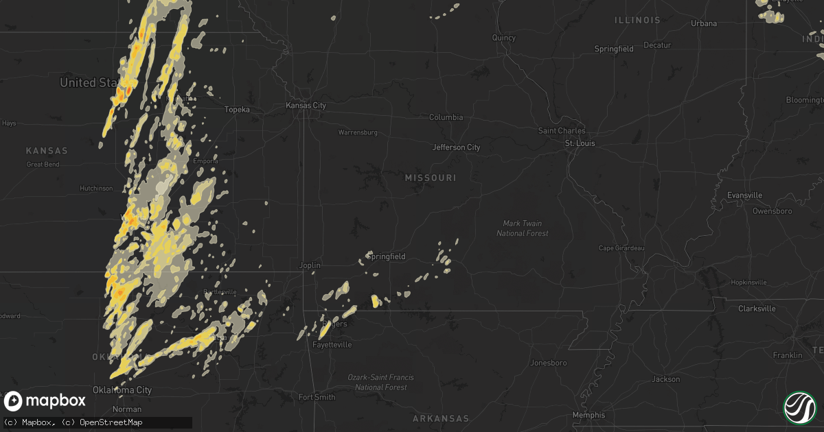
Hail Map in Iowa on June 20, 2011
Get this storm
June 20 map
$229
one time, instant access
Download today. No call, no setup
Keep the $229
Bought the map and want the full workflow? Apply the entire $229 to a subscription within 7 days. None of it is wasted.
Every map, not just this one
This buys you this map. Subscription and you get every map we run, in the markets you choose from a few cities to whole states to nationwide. Plus real-time alerts the moment a storm fires.
Contact data
Name, contact info, occupancy, even credit band for addresses in the footprint. You go from where it hit to who to call.
Become the source they trust
Unlimited branding weather history reports on demand. You already have the documented answer ready for the property owner, and you are the one who showed up with it.
Property data and RoofTrace estimates
Pull up any address you have got, its value and the exact code rules for that jurisdiction, straight from One Click Code. Then RoofTrace estimates the squares, pitch, and roof value, priced the way you price.
Storm reports in Iowa
Iowa
| Date | Description |
|---|---|
| 06/20/201111:59 AM CDT | Tornado was reported on the ground at hwy 65 and ne 112th st. |
| 06/20/20111:30 AM CDT | Aluminum machine shed ripped off its foundation and blown anticyclonically north and east and destroyed. Debris from the shed then continued on an anticyclonic path and |
| 06/20/20111:30 AM CDT | A number of 1 to 3 foot diameter trees down across the city. |
| 06/20/20111:20 AM CDT | A local report indicates 60 MPH wind near CHARLES CITY |
| 06/20/20111:15 AM CDT | Farm site on highway v18 with large trees down. Minor damage to house with gutter blown into truck. Roof off outbuilding. In clutier numerous large tree limbs also down |
| 06/20/20111:15 AM CDT | Farm site on highway v18 with tops of large trees snapped off. Minor damage to house with gutter blown into truck. Roof off outbuilding. Narrow damage path was very loc |
| 06/20/20111:10 AM CDT | Many branches down. Gazebo blown apart and debris strewn along a southwest to northeast path approximately 75 feet long. Some debris and grass embedded 4 to 6 inches in |
| 06/20/201112:45 AM CDT | Trees down in town. Heard over scanner. |
| 06/20/201112:30 AM CDT | Six and one half inch diameter branch down outside the radio station. |
| 06/20/201112:30 AM CDT | Small tree 8 to 10 inches in diameter snapped off at the base. |
| 06/20/201112:22 AM CDT | Touchdown difficult to see but is visible through lightning |
| 06/19/201111:59 PM CDT | Tornado was reported on the ground at hwy 65 and ne 112th st. |
| 06/19/201111:48 PM CDT | 66ft wide by 76 ft long by 50 ft high barn destroyed. Grain bin blown off its concrete pad. Debris in yard. Grass and corn uprooted and blown across highway. |
| 06/19/201111:30 PM CDT | Surveyed by emergency manager. One third of roof of quonset storage building torn off. Landed to the north of the building. |
| 06/19/201111:30 PM CDT | Surveyed by emergency manager. Three fourths of grove of trees down. Shingle damage to house. Debris to north. |
| 06/19/201111:30 PM CDT | Surveyed by emergency manager. House had walls bowed in and out. Part of roof off house. Motor from a grain auger launched into attic of house. Grain bins and trees dow |
| 06/19/201111:18 PM CDT | Powerlines and trees blown down. Estimate 80 mph winds. Pea size hail also reported. |
| 06/19/201111:10 PM CDT | Several 6 inch tree limbs down in town. Time based on radar. |
| 06/19/201111:00 PM CDT | Nickel hail reported as well. |
| 06/19/201110:50 PM CDT | 3 stall garage moved off foundation |
| 06/19/201110:45 PM CDT | Machine shed roof damage on white ave as well as trees down on houses and across roads |
| 06/19/201110:42 PM CDT | Tree damage in spencer due to strong winds. |
| 06/19/201110:35 PM CDT | Two hog confinements had partial roof damage. |
| 06/19/201110:33 PM CDT | Extremely heavy rain |
| 06/19/201110:30 PM CDT | Part of a machine shed roof torn off |
| 06/19/201110:25 PM CDT | Two hog confinements had partial roof damage. |
| 06/19/201110:15 PM CDT | Trees down |
| 06/19/201110:12 PM CDT | Local law enforcement reports a power line and fencing blown down near the 1500 block of highway 71 in carroll. |
| 06/19/201110:10 PM CDT | Large trees down |
| 06/19/201110:04 PM CDT | Multiple moderate sized tree limbs down in town. Time based on radar |
| 06/19/201110:00 PM CDT | Machine shed roof damage on white ave as well as trees down on houses and across roads |
| 06/19/201110:00 PM CDT | 2 to 3 foot trees downed. Some trees on cars. |
| 06/19/20119:53 PM CDT | Spotter estimated up to 60 mph gusts and reports 3 to 6 inch branches down. |
| 06/19/20119:45 PM CDT | Tree toppled and a few branches broken on nearby trees. Observed near the airport. Time estimated from radar. |
| 06/19/20119:40 PM CDT | Numerous farm buildings and grain bins damaged. |
| 06/19/20119:30 PM CDT | 6-12 inch diameter branches down...roads closed due to downed tree branches |
| 06/19/20119:30 PM CDT | Large tree branches blown down in battle creek and a lose of power. |
| 06/19/20119:24 PM CDT | A local report indicates 60 MPH wind near 7 W RED OAK |
| 06/19/20119:20 PM CDT | *** 2 inj *** roof torn off 3 homes...and around 40 more homes with major roof damage. Significant tree damage in town. 4 campers destroyed at the fairgrounds...with 2 |
| 06/19/20119:12 PM CDT | Just southwest of mapleton a semi was blown over on hwy 141 and a grain bin was blown across hwy 141. |
| 06/19/20119:12 PM CDT | A local report indicates 60 MPH wind near OTO |
| 06/19/20119:10 PM CDT | Trained spotter reports wind gusts of at least 60 mph with storm front. Time estimated from radar. |
| 06/19/20119:04 PM CDT | A local report indicates 70 MPH wind near 2 N SALIX |
| 06/19/20118:45 PM CDT | 1 large tree blown down. |
| 06/19/20118:43 PM CDT | A tree fell on a house. |
| 06/19/20118:30 PM CDT | Trees and power lines down. |
| 06/19/20118:30 PM CDT | Trees and power lines down in missouri valley. |
| 06/19/20117:55 PM CDT | Tree down near dispatcher residence northwest of town. |
All States Impacted by Hail Map on June 20, 2011
Cities Impacted by Hail Map on June 20, 2011
- Elkader, IA
- Saint Paul, NE
- Wolbach, NE
- Wayne, NE
- Neligh, NE
- Cazenovia, WI
- Winthrop, IA
- Oxford, IN
- Boswell, IN
- Fowler, IN
- Fort Atkinson, IA
- Calmar, IA
- Castana, IA
- Soldier, IA
- Carroll, NE
- Lansing, IA
- New Richmond, IN
- Crawfordsville, IN
- McCook, NE
- Veedersburg, IN
- Attica, IN
- Gypsum, KS
- Woodbine, KS
- Chapman, KS
- Colby, KS
- Atwood, KS
- Ludell, KS
- Herndon, KS
- Dwight, KS
- White City, KS
- Junction City, KS
- Newton, KS
- Walton, KS
- Peabody, KS
- Hartford, KS
- Hamilton, KS
- Eureka, KS
- Madison, KS
- Lehigh, KS
- Canton, KS
- Frenchburg, KY
- Slade, KY
- Emporia, KS
- Reading, KS
- Hillsboro, KS
- Deerfield, KS
- Oklahoma City, OK
- Lampe, MO
- Reeds Spring, MO
- Galena, MO
- Shell Knob, MO
- Kimberling City, MO
- Pryor, OK
- Inola, OK
- Claremore, OK
- Tulsa, OK
- Southlake, TX
- Dallas, TX
- Grapevine, TX
- Vinita, OK
- Pritchett, CO
- Merkel, TX
- Ramona, OK
- Talala, OK
- Bartlesville, OK
- Campton, KY
- South Haven, KS
- Barnsdall, OK
- Coleman, TX
- Novice, TX
- Marble Rock, IA
- Greene, IA
- Max, NE
- Wichita, KS
- Hoxie, KS
- Oxford, NE
- Manilla, IN
- Dunlap, IA
- Woodbine, IA
- Riceville, IA
- Osage, IA
- Pickrell, NE
- Clatonia, NE
- Adams, NE
- Cortland, NE
- De Witt, NE
- Wilber, NE
- Beatrice, NE
- Hallam, NE
- Rock, KS
- Udall, KS
- Mulvane, KS
- Douglass, KS
- Rose Hill, KS
- Latham, KS
- Leon, KS
- Weatherford, TX
- Duncan, OK
- Tussy, OK
- Hennepin, OK
- Ratliff City, OK
- Elmore City, OK
- Sand Springs, OK
- Sperry, OK
- Mannford, OK
- Yale, OK
- Drumright, OK
- Cushing, OK
- Skiatook, OK
- Kellyville, OK
- Cleveland, OK
- Sapulpa, OK
- Jennings, OK
- Garfield, AR
- Wynnewood, OK
- Dexter, KS
- Maple City, KS
- Shidler, OK
- Arlington, TX
- Fort Worth, TX
- Naval Air Station Jrb, TX
- Lone Rock, WI
- Richland Center, WI
- Vinton, IA
- Greensburg, IN
- Saint Paul, IN
- Norfolk, NE
- Battle Creek, NE
- Riley, KS
- Olsburg, KS
- Manhattan, KS
- Sheridan Lake, CO
- Arapahoe, CO
- Elmdale, KS
- Marion, KS
- Cedar Point, KS
- Benton, KS
- Andover, KS
- Mcconnell Afb, KS
- Haysville, KS
- Clearwater, KS
- Valley Center, KS
- Conway Springs, KS
- Derby, KS
- Maize, KS
- Alda, NE
- Grand Island, NE
- Aurora, NE
- Harvard, NE
- Abilene, TX
- Loup City, NE
- Litchfield, NE
- Ravenna, NE
- Colwell, IA
- Charles City, IA
- Holton, IN
- Osgood, IN
- Abilene, KS
- Manter, KS
- Johnson, KS
- Lakin, KS
- Walsh, CO
- Ulysses, KS
- Winfield, KS
- Belle Plaine, KS
- Wellington, KS
- Lamont, OK
- Nardin, OK
- Medford, OK
- Deer Creek, OK
- Hunter, OK
- Crescent, OK
- Elba, NE
- Clifton, KS
- Bowie, TX
- Henrietta, TX
- Bellevue, TX
- Bertrand, NE
- Arkansas City, KS
- Towanda, KS
- Mount Olivet, KY
- Mayslick, KY
- Germantown, KY
- Caldwell, KS
- Henderson, NE
- Hampton, NE
- Bradshaw, NE
- Burden, KS
- Cambridge, KS
- Buffalo Gap, TX
- Ovalo, TX
- Tuscola, TX
- Waterville, KS
- Blue Rapids, KS
- Delphos, KS
- Miltonvale, KS
- Cambridge, NE
- Wilsonville, NE
- Granada, CO
- Piedmont, KS
- Chico, TX
- Flower Mound, TX
- Lewisville, TX
- Jacksboro, TX
- Windthorst, TX
- Albany, TX
- Lenora, KS
- Scott City, KS
- Graford, TX
- Perrin, TX
- Oakley, KS
- Monument, KS
- Overton, NE
- Haddam, KS
- Humphrey, NE
- Monroe, NE
- Madison, NE
- Platte Center, NE
- Newcastle, TX
- Azle, TX
- Poolville, TX
- Springtown, TX
- Morrowville, KS
- Woodson, TX
- Grinnell, KS
- Graham, TX
- Bryson, TX
- Palmer, KS
- Linn, KS
- Greenleaf, KS
- Washington, KS
- Herington, KS
- Hope, KS
- Meridian, OK
- Guthrie, OK
- Ponca City, OK
- Burbank, OK
- Genoa, NE
- Columbus, NE
- Silver Creek, NE
- Lindsay, NE
- South Bend, TX
- Breckenridge, TX
- Elm Creek, NE
- Miller, NE
- Amherst, NE
- Prairie Du Chien, WI
- Bloomington, WI
- Bagley, WI
- Cassville, WI
- Glen Haven, WI
- Garnavillo, IA
- Guttenberg, IA
- Modale, IA
- Missouri Valley, IA
- Fairbury, NE
- Endicott, NE
- Clay Center, KS
- Tescott, KS
- Swanton, NE
- Bennington, KS
- Morganville, KS
- Agenda, KS
- Steele City, NE
- Jansen, NE
- Minneapolis, KS
- Aurora, KS
- Diller, NE
- Plymouth, NE
- Mahaska, KS
- Salina, KS
- Hollenberg, KS
- Cuba, KS
- Clyde, KS
- Concordia, KS
- Lindsborg, KS
- Newkirk, OK
- Ripley, OH
- Yankton, SD
- Mission Hill, SD
- Volin, SD
- Pilot Point, TX
- Gunter, TX
- Aubrey, TX
- Decatur, TX
- Sanger, TX
- Celina, TX
- Van Alstyne, TX
- Marlow, OK
- Aplington, IA
- Ackley, IA
- Dumont, IA
- Jermyn, TX
- Agra, OK
- Perkins, OK
- Tryon, OK
- Rhome, TX
- Hendley, NE
- Arapahoe, NE
- Beaver City, NE
- Stamford, NE
- Selden, KS
- Penokee, KS
- Norton, KS
- Quinter, KS
- Almena, KS
- Hill City, KS
- Morland, KS
- Grainfield, KS
- Park, KS
- Montgomery, LA
- Colfax, LA
- Cloutierville, LA
- Elgin, NE
- Polk, NE
- Ponder, TX
- Friend, NE
- Waco, NE
- Exeter, NE
- Milligan, NE
- York, NE
- Cordova, NE
- Perry, OK
- Throckmorton, TX
- Flemingsburg, KY
- Ewing, KY
- Moorefield, KY
- Indianapolis, IN
- Clyde, TX
- Lawn, TX
- Tye, TX
- Dyess Afb, TX
- Wakefield, KS
- Leonardville, KS
- Randolph, KS
- Nashua, IA
- Waverly, IA
- Plainfield, IA
- Council Grove, KS
- Eads, CO
- Mount Sterling, KY
- Owingsville, KY
- Fall River, KS
- Eagle Rock, MO
- Eureka Springs, AR
- Olney, TX
- Palmer, IA
- Rolfe, IA
- Pocahontas, IA
- Gilmore City, IA
- Sutherland, NE
- Bridgeport, TX
- Hesston, KS
- Halstead, KS
- Moundridge, KS
- Alta Vista, KS
- Cave Springs, AR
- Gentry, AR
- Rogers, AR
- Springdale, AR
- Bentonville, AR
- Stillwater, OK
- Ida Grove, IA
- Carroll, IA
- Floyd, IA
- Westmoreland, KS
- Burns, KS
- Aledo, TX
- Flat Rock, IN
- Irving, TX
- Blackwell, OK
- Braman, OK
- Atlanta, KS
- Postville, IA
- Syracuse, KS
- Ogden, KS
- Falmouth, KY
- Brooksville, KY
- Augusta, KY
- Coolidge, KS
- Waterville, IA
- Cleghorn, IA
- Marcus, IA
- Irene, SD
- Meadow Grove, NE
- Osceola, NE
- Clarks, NE
- Hordville, NE
- Osmond, NE
- Saint Edward, NE
- Stromsburg, NE
- Pierce, NE
- Newman Grove, NE
- Tilden, NE
- Blairstown, IA
- Van Horne, IA
- Marengo, IA
- Pleasanton, NE
- Albion, NE
- Marquette, NE
- Chalmers, IN
- Axtell, KS
- Phillips, NE
- New Berlin, IL
- Pleasant Plains, IL
- Rushville, IN
- Milroy, IN
- Holcomb, KS
- Florence, KS
- Lincolnville, KS
- Cassoday, KS
- Strong City, KS
- Cottonwood Falls, KS
- Blackey, KY
- Cornettsville, KY
- Letcher, KY
- Vanzant, MO
- Drury, MO
- Lamar, CO
- Milan, KS
- Kim, CO
- Chelsea, OK
- Crane, MO
- Billings, MO
- Campo, CO
- Oxford, KS
- Tonkawa, OK
- Mulhall, OK
- Edmond, OK
- Coyle, OK
- Piedmont, OK
- Morrison, OK
- Orlando, OK
- Yukon, OK
- Bartlett, NE
- Spalding, NE
- Muscoda, WI
- Allison, IA
- Covington, OK
- Douglas, OK
- Lucien, OK
- Marshall, OK
- Mead, NE
- Paxton, NE
- Fairfax, OK
- Carney, OK
- Ripley, OK
- Wellston, OK
- Luther, OK
- Arcadia, OK
- Lexington, NE
- Smithfield, NE
- Sumner, NE
- Weskan, KS
- Sharon Springs, KS
- Wallace, KS
- Garber, OK
- Billings, OK
- Mesquite, TX
- Grenola, KS
- Haslet, TX
- Roanoke, TX
- Pond Creek, OK
- Owasso, OK
- Collinsville, OK
- Alvord, TX
- Krum, TX
- Denton, TX
- Loving, TX
- Schleswig, IA
- Charter Oak, IA
- Aurelia, IA
- Galva, IA
- Forest City, IA
- Ionia, IA
- Orchard, IA
- Doniphan, NE
- Wingate, IN
- Waynetown, IN
- Romney, IN
- Wauneta, NE
- Saronville, NE
- Bird City, KS
- Sterling, NE
- Belleville, KS
- Hillsboro, KY
- Longford, KS
- Durham, KS
- Enterprise, KS
- Purdy, MO
- Wheaton, MO
- Exeter, MO
- Rocky Comfort, MO
- Ava, MO
- Hazard, KY
- Chavies, KY
- Rowdy, KY
- Warbranch, KY
- Roark, KY
- Manchester, KY
- Essie, KY
- Terlton, OK
- Okeechobee, FL
- Balch Springs, TX
- Clearwater, NE
- Petersburg, NE
- Albert City, IA
- Fonda, IA
- Laurens, IA
- Butlerville, IN
- Farwell, NE
- Dannebrog, NE
- Rockville, NE
- Ashton, NE
- Kechi, KS
- Sedgwick, KS
- Argonia, KS
- Goodland, KS
- Cheyenne Wells, CO
- Edson, KS
- Lueders, TX
- Fremont, NE
- Arlington, NE
- Temple, OK
- Malmo, NE
- Liberty, NE
- Virginia, NE
- Wilsey, KS
- Geuda Springs, KS
- Comanche, OK
- Waurika, OK
- Argyle, TX
- Justin, TX
- Jackson, KY
- Riverdale, NE
- Kearney, NE
- Dundee, IA
- Lohrville, IA
- Lake City, IA
- Giltner, NE
- Ewing, NE
- Avoca, IA
- Indianola, NE
- Greenwood, IN
- Burdick, KS
- Beattyville, KY
- Carlisle, KY
- Cynthiana, KY
- Sharpsburg, KY
- Howard, KS
- Bradleyville, MO
- Forsyth, MO
- Fairview, MO
- Stella, MO
- Anderson, MO
- Colcord, OK
- Oologah, OK
- West Union, IA
- Scotia, NE
- Greeley, NE
- Pine Village, IN
- Brewster, KS
- Levant, KS
- Coeburn, VA
- Wise, VA
- Broken Arrow, OK
- Catoosa, OK
- Randlett, OK
- Sunnyvale, TX
- Kendall, KS
- Leoti, KS
- Marienthal, KS
- Augusta, KS
- El Dorado, KS
- Foster, KY
- Home, KS
- Marysville, KS
- Oketo, KS
- Wymore, NE
- Butterfield, MO
- Enid, OK
- Fairmont, OK
- Batesville, IN
- Gainesville, TX
- Boyd, TX
- Whitt, TX
- Mineral Wells, TX
- Menno, SD
- Freeman, SD
- Viborg, SD
- Newell, IA
- Strawberry Point, IA
- Edgewood, IA
- Masonville, IA
- Ithaca, NE
- Clarksville, IA
- North Bend, NE
- Tobias, NE
- Beaver Crossing, NE
- McCool Junction, NE
- Galveston, IN
- Hazard, NE
- Gibbon, NE
- Rexford, KS
- Otterbein, IN
- West Lafayette, IN
- Oberlin, KS
- Norcatur, KS
- Westport, IN
- Hope, KY
- Jeffersonville, KY
- Means, KY
- Chatham, VA
- Butler, KY
- Berry, KY
- Neville, OH
- Maysville, KY
- California, KY
- Moscow, OH
- Georgetown, OH
- Dover, KY
- Bethel, OH
- Felicity, OH
- Sunset, TX
- Hominy, OK
- Dewey, OK
- Copan, OK
- Keller, TX
- Honey Grove, TX
- Hastings, OK
- Pawnee, OK
- Rockford, IA
- Holliday, TX
- Castalia, IA
- Barnes, KS
- Green, KS
- Healy, KS
- Newark, TX
- Paradise, TX
- Laurel, NE
- Concord, NE
- Wakefield, NE
- Benkelman, NE
- Laurel, IN
- Longton, KS
- Stanton, KY
- Hennessey, OK
- Waukomis, OK
- Kremlin, OK
- Rockwall, TX
- Wichita Falls, TX
- Terrell, TX
- Seagoville, TX
- Boscobel, WI
- Blue River, WI
- Era, TX
- Tyndall, SD
- Tabor, SD
- Williamsport, IN
- Fort Riley, KS
- Rensselaer, IN
- Dedham, IA
- Coon Rapids, IA
- Glidden, IA
- Branson, MO
- Virgil, KS
- Potwin, KS
- Mayfield, KS
- Kaw City, OK
- Siloam Springs, AR
- Mounds, OK
- Valley View, TX
- Lake Dallas, TX
- Tioga, TX
- Rosston, TX
- Howe, TX
- Anna, TX
- Sherman, TX
- Cedar Vale, KS
- Springfield, CO
- Beaumont, KS
- Kesley, IA
- Bristow, IA
- Morse Bluff, NE
- Crete, NE
- Martell, NE
- Tecumseh, NE
- Zionsville, IN
- Whitestown, IN
- Westfield, IN
- Carmel, IN
- Frankfort, KS
- Waldron, IN
- Napoleon, IN
- Milan, IN
- Whiteland, IN
- Saint George, KS
- Wamego, KS
- Monett, MO
- Cassville, MO
- Whitewater, KS
- Loxahatchee, FL
- Ossian, IA
- Clermont, IA
- Fordyce, NE
- Utica, SD
- Saint Helena, NE
- Crofton, NE
- Barneston, NE
- Blue Springs, NE
- Gayville, SD
- Mondamin, IA
- McIntire, IA
- Toledo, IA
- Bode, IA
- Humboldt, IA
- Valley, NE
- Lincoln, NE
- North Loup, NE
- Holbrook, NE
- Greenwich, KS
- Moline, KS
- Mountain Grove, MO
- Norwood, MO
- Seligman, MO
- Mckinney, TX
- Bonham, TX
- Ector, TX
- Prue, OK
- Viroqua, WI
- New Lisbon, WI
- Mauston, WI
- Mabel, MN
- Kenyon, MN
- Decorah, IA
- Elgin, IA
- New Hampton, IA
- Alta Vista, IA
- Emmetsburg, IA
- Curlew, IA
- Geneva, IA
- Rutland, IA
- Sutherland, IA
- Irwin, IA
- Manilla, IA
- Audubon, IA
- Homer, NE
- Hubbard, NE
- Emerson, NE
- Churdan, IA
- Watkins, IA
- Newhall, IA
- Oakland, NE
- Craig, NE
- Tekamah, NE
- Norwalk, IA
- Prole, IA
- Cumming, IA
- Scribner, NE
- Prague, NE
- Cedar Bluffs, NE
- Harlan, IA
- Wahoo, NE
- Colon, NE
- Yutan, NE
- Syracuse, NE
- Wolcott, IN
- Monon, IN
- Monticello, IN
- Winterset, IA
- Shelbyville, IN
- Emmett, KS
- Saint Marys, KS
- Tampa, KS
- Alma, KS
- New Richmond, OH
- Wallingford, KY
- Tollesboro, KY
- De Mossville, KY
- Hamersville, OH
- Toronto, KS
- Zoe, KY
- Vancleve, KY
- Booneville, KY
- Rogers, KY
- Moran, KS
- McKee, KY
- Vincent, KY
- Stinnett, KY
- Hyden, KY
- Aurora, MO
- Marionville, MO
- Vilas, CO
- Elk City, KS
- Thousandsticks, KY
- Jones, OK
- Bixby, OK
- Jenks, OK
- Decatur, AR
- Cashion, OK
- Whitewright, TX
- Trenton, TX
- Caddo, TX
- Crandall, TX
- Forney, TX
- West Palm Beach, FL
- Wellington, FL
- Fort Myers, FL
- Lehigh Acres, FL
- Wisconsin Rapids, WI
- Rudolph, WI
- Norwalk, WI
- Port Edwards, WI
- Nekoosa, WI
- Manly, IA
- Mason City, IA
- Manchester, IA
- Lamont, IA
- Readlyn, IA
- Denver, IA
- Luana, IA
- Cherokee, IA
- Larrabee, IA
- Mclean, NE
- Randolph, NE
- Denison, IA
- Alta, IA
- Holstein, IA
- Moville, IA
- Lesterville, SD
- Rosalie, NE
- Macy, NE
- Decatur, NE
- Lyons, NE
- North Vernon, IN
- Sunman, IN
- Hope, IN
- Hartsville, IN
- Oldenburg, IN
- Rutledge, MO
- Baring, MO
- Memphis, MO
- Pleasantville, IA
- Belvue, KS
- Hershey, NE
- Mora, LA
- Savoy, TX
- Adair, OK
- Dodson, LA
- Jonesboro, LA
- Winona, KS
- Pound, VA
- Mayking, KY
- Elkhart, KS
- Maramec, OK
- Grand Prairie, TX
- Mansfield, TX
- Bedford, VA
- Bulan, KY
- Krypton, KY
- Lost Creek, KY
- Ary, KY
- Hartville, MO
- Mansfield, MO
- Graff, MO
- Brinson, GA
- Lost Springs, KS
- Ramona, KS
- West Concord, MN
- De Soto, WI
- Spring Grove, MN
- Peterson, MN
- Rushford, MN
- Wonewoc, WI
- Elroy, WI
- Ridgeway, IA
- Cresco, IA
- Harpers Ferry, IA
- Waukon, IA
- Le Mars, IA
- Hinton, IA
- Volga, IA
- Britt, IA
- Garner, IA
- Dodgeville, WI
- Quimby, IA
- Tripoli, IA
- Sac City, IA
- Lake View, IA
- Ericson, NE
- Independence, IA
- Battle Creek, IA
- Clare, IA
- Garwin, IA
- Vail, IA
- Clutier, IA
- Traer, IA
- Tama, IA
- State Center, IA
- Kimballton, IA
- Kirkman, IA
- Van Meter, IA
- Mason City, NE
- Walnut, IA
- Omaha, NE
- Bennington, NE
- Clearfield, IA
- Red Oak, IA
- Clay Center, NE
- Brookston, IN
- Earl Park, IN
- Battle Ground, IN
- Lafayette, IN
- Brashear, MO
- Kirksville, MO
- Pawnee City, NE
- Steinauer, NE
- Vermillion, KS
- Baileyville, KS
- Beattie, KS
- Summerfield, KS
- Rossville, KS
- Americus, KS
- Sabetha, KS
- Sedan, KS
- Irvine, KY
- Plato, MO
- Bucyrus, MO
- Chanute, KS
- Ash Grove, MO
- Bois D Arc, MO
- Republic, MO
- Galesburg, KS
- Thayer, KS
- Mozelle, KY
- Clever, MO
- Nowata, OK
- Chautauqua, KS
- Peru, KS
- Hollister, MO
- Beggs, OK
- Bells, TX
- Goldsboro, TX
- Baird, TX
- Downsville, LA
- Houston, MN
- Blair, WI
- Whitehall, WI
- Dunnell, MN
- Rudd, IA
- Elma, IA
- Woden, IA
- Buffalo Center, IA
- Titonka, IA
- Hampton, IA
- Lancaster, WI
- Mount Hope, WI
- Marquette, IA
- McGregor, IA
- Mount Auburn, IA
- Breda, IA
- Dixon, NE
- Belden, NE
- Moorhead, IA
- Runnells, IA
- Mitchellville, IA
- Hickman, NE
- Hebron, NE
- Gove, KS
- Hiawatha, KS
- Whitesburg, KY
- Gridley, KS
- Burlington, KS
- Slemp, KY
- Eolia, KY
- Mount Vernon, MO
- Centerton, AR
- Gravette, AR
- Hiwasse, AR
- Bella Vista, AR
- Taneyville, MO
- Blue Ridge, TX
- Quinlan, TX
- Lime Springs, IA
- Waucoma, IA
- Fennimore, WI
- Woodman, WI
- Highland, WI
- Avoca, WI
- Montfort, WI
- Hillsboro, WI
- Primghar, IA
- Paullina, IA
- Dougherty, IA
- Havelock, IA
- Algona, IA
- Livermore, IA
- Lu Verne, IA
- Sumner, IA
- Alexander, IA
- Meservey, IA
- Arlington, IA
- Duncombe, IA
- Colo, IA
- Nevada, IA
- Gladbrook, IA
- Beaman, IA
- Grundy Center, IA
- Reinbeck, IA
- Walthill, NE
- Pender, NE
- West Point, NE
- Hooper, NE
- Nickerson, NE
- Herman, NE
- Adel, IA
- Ashland, NE
- Waverly, NE
- Ceresco, NE
- Greenwood, NE
- Fort Calhoun, NE
- Ames, NE
- Griswold, IA
- Humboldt, NE
- Ohiowa, NE
- Tribune, KS
- Matfield Green, KS
- Admire, KS
- Allen, KS
- Independence, KS
- Hallie, KY
- Roxana, KY
- Bristow, OK
- Bluejacket, OK
- Welch, OK
- Spring Green, WI
- Lawler, IA
- Fredericksburg, IA
- Shelby, IA
- Panama, IA
- Friendship, WI
- Farnhamville, IA
- Royal, NE
- Orchard, NE
- Brunswick, NE
- Dow City, IA
- Redfield, IA
- Emmons, MN
- Lake Mills, IA
- Hixton, WI
- Washta, IA
- Pierson, IA
- Correctionville, IA
- Montour, IA
- Marshalltown, IA
- North Prairie, WI
- Waukesha, WI
- Meriden, IA
- Somers, IA
- Callender, IA
- Gowrie, IA
- Sutton, NE
- Trumbull, NE
- Roca, NE
- Solomon, KS
- Seneca, KS
- Hull, IL
- Tyner, KY
- Holly, CO
- Pine Ridge, KY
- Clay City, KY
- Wellington, KY
- Ravenna, KY
- Bartlett, KS
- Edna, KS
- Caney, KS
- Olpe, KS
- Powell, MO
- Pawhuska, OK
- Gordon, KY
- Cumberland, KY
- Ochelata, OK
- Wynona, OK
- Castle, OK
- Okemah, OK
- Sumner, TX
- Collinsville, TX
- Forestburg, TX
- North Richland Hills, TX
- Colleyville, TX
- Millsap, TX
- Little Elm, TX
- Hurst, TX
- Haltom City, TX
- Coppell, TX
- Euless, TX
- Plano, TX
- The Colony, TX
- Frisco, TX
- Winnfield, LA
- Carrollton, TX
- Loomis, NE
- Keystone, IA
- Garrison, IA
- La Valle, WI
- Hartington, NE
- New Albin, IA
- Narka, KS
- Niotaze, KS
- Goodell, IA
- Las Animas, CO
- Hillpoint, WI
- Wann, OK
- Winters, TX
- Ferryville, WI
- Arena, WI
- Lebanon, IN
- Denton, NE
- Jackson, NE
- Dakota City, NE
- Lenox, IA
- Prescott, IA
- Ashland, IL
- Alexander, IL
- Talpa, TX
- Francesville, IN
- Medaryville, IN
- Ranger, TX
- Ricetown, KY
- Worthington, MN
- Wynot, NE
- Marathon, IA
- Bancroft, NE
- Palo Pinto, TX
- Walton, IN
- Elk Falls, KS
- Parkersburg, IA
- Delphi, IN
- North Fort Myers, FL
- Covington, IN
- Newtown, IN
- Westpoint, IN
- Hillsboro, IN
- Mellott, IN
- Chester, IA
- Le Roy, MN
- Hawkeye, IA
- Round Lake, MN
- Fountain City, WI
- Rockwell, IA
- Sioux City, IA
- Elkport, IA
- Garber, IA
- Colesburg, IA
- Greeley, IA
- Lawton, IA
- Wellsburg, IA
- Austinville, IA
- Walker, IA
- Rowley, IA
- Center Point, IA
- Urbana, IA
- Central City, NE
- Winnebago, NE
- Kennard, NE
- Belgrade, NE
- West Des Moines, IA
- Waukee, IA
- Booneville, IA
- Brook, IN
- Remington, IN
- Red Rock, OK
- Ralston, OK
- Elbing, KS
- Western, NE
- Marland, OK
- Odell, NE
- Filley, NE
- Lewiston, NE
- Severy, KS
- Brookville, KS
- Peck, KS
- Crab Orchard, NE
- Burchard, NE
- Rosalia, KS
- Bethany, MO
- McFall, MO
- Plainfield, IN
- Franklin, IN
- West Newton, IN
- Cicero, IN
- Beech Grove, IN
- Camby, IN
- Avon, IN
- Boggstown, IN
- Needham, IN
- Fairland, IN
- Sheridan, IN
- Bargersville, IN
- Brownsburg, IN
- Yates Center, KS
- Viper, KY
- Tyro, KS
- Bledsoe, KY
- Chappell, KY
- Dryden, VA
- Big Stone Gap, VA
- Jay, OK
- Fayetteville, AR
- Pineville, MO
- Okmulgee, OK
- Zwolle, LA
- Many, LA
- Duffield, VA
- Pennington Gap, VA
- Blue Eye, MO
- Royse City, TX
- Eucha, OK
- Vernon, AL
- Duncanville, TX
- Sparta, WI
- Lake Park, IA
- Lakefield, MN
- Sauk City, WI
- Adams, WI
- Rockwell City, IA
- Aurora, IA
- Fayette, IA
- Hazleton, IA
- Thurston, NE
- Hudson, IA
- Cedar Falls, IA
- Manson, IA
- Fort Dodge, IA
- Primrose, NE
- Cedar Rapids, NE
- Onawa, IA
- Jefferson, IA
- Scranton, IA
- Urbandale, IA
- Grimes, IA
- Belle Plaine, IA
- Boelus, NE
- Cairo, NE
- Blair, NE
- Otoe, NE
- Benedict, NE
- Ambia, IN
- Kokomo, IN
- Falun, KS
- Marquette, KS
- Neosho, MO
- Joplin, MO
- Delaware, OK
- Arthur City, TX
- Osage, OK
- Kiefer, OK
- Cisco, TX
- Kaufman, TX
- Lena, LA
- Provencal, LA
- Welsh, LA
- Kinder, LA
- Hawley, TX
- Alma Center, WI
- Merrillan, WI
- Black River Falls, WI
- Taylor, WI
- Clear Lake, IA
- Ventura, IA
- Boyd, WI
- Mineral Point, WI
- Oelwein, IA
- Hornick, IA
- Rodney, IA
- Smithland, IA
- Lytton, IA
- Jolley, IA
- Shellsburg, IA
- Luzerne, IA
- Portsmouth, IA
- Victor, IA
- Ladora, IA
- Haverhill, IA
- Laurel, IA
- Winamac, IN
- Bunker Hill, IN
- Amboy, IN
- Hurdland, MO
- Moores Hill, IN
- Paris, KY
- Independence, KY
- Newport, KY
- Alexandria, KY
- Latonia, KY
- Goessel, KS
- Keeling, VA
- Java, VA
- Watts, OK
- Glenpool, OK
- Choudrant, LA


