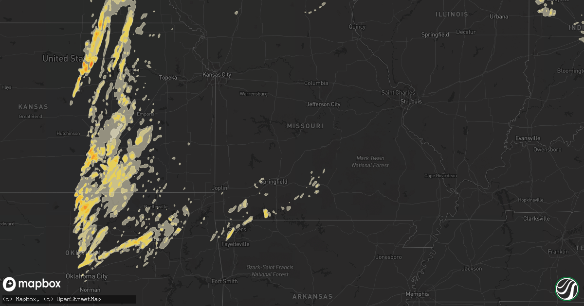
Hail Map in Kansas on June 20, 2011
Get this storm
June 20 map
$229
one time, instant access
Download today. No call, no setup
Keep the $229
Bought the map and want the full workflow? Apply the entire $229 to a subscription within 7 days. None of it is wasted.
Every map, not just this one
This buys you this map. Subscription and you get every map we run, in the markets you choose from a few cities to whole states to nationwide. Plus real-time alerts the moment a storm fires.
Contact data
Name, contact info, occupancy, even credit band for addresses in the footprint. You go from where it hit to who to call.
Become the source they trust
Unlimited branding weather history reports on demand. You already have the documented answer ready for the property owner, and you are the one who showed up with it.
Property data and RoofTrace estimates
Pull up any address you have got, its value and the exact code rules for that jurisdiction, straight from One Click Code. Then RoofTrace estimates the squares, pitch, and roof value, priced the way you price.
Storm reports in Kansas
Kansas
| Date | Description |
|---|---|
| 06/20/20116:59 PM CDT | Dime size hail as well. |
| 06/20/20116:59 PM CDT | A local report indicates 1.00 inch wind near 5 NE UDALL |
| 06/20/20116:58 PM CDT | 4 large trees blown down. Time estimated. |
| 06/20/20116:55 PM CDT | Spotter reports 60 to 70 mph winds. |
| 06/20/20116:51 PM CDT | A local report indicates 1.00 inch wind near TOWANDA |
| 06/20/20116:51 PM CDT | Estimated 60mph winds and 1/2 inch hail in douglass. |
| 06/20/20116:51 PM CDT | 60 to 70 mph winds west side of el dorado. |
| 06/20/20116:51 PM CDT | A local report indicates 60 MPH wind near 4 NE UDALL |
| 06/20/20116:51 PM CDT | 60 to 70 mph winds west side of el dorado. |
| 06/20/20116:50 PM CDT | Paint was chipped off of one side of house. 3 inch tree limbs down. Dime size hail also reported. Radar estimated time. |
| 06/20/20116:45 PM CDT | A local report indicates a tornado near 3 NW REAGER |
| 06/20/20116:44 PM CDT | A local report indicates 1.25 inch wind near RILEY |
| 06/20/20116:29 PM CDT | Rotation in clouds looking north east of 13th and 143rd street. |
| 06/20/20116:25 PM CDT | A local report indicates a tornado near 5 NE NORCATUR |
| 06/20/20116:24 PM CDT | A local report indicates 60 MPH wind near JABARA AIRPORT |
| 06/20/20116:20 PM CDT | 5 power poles down at macarthur and ridge roads. |
| 06/20/20116:17 PM CDT | At friends university. |
| 06/20/20116:16 PM CDT | Estimated 60mph winds. Pea size hail as well. |
| 06/20/20116:12 PM CDT | A local report indicates 1.50 inch wind near 2 SE WICHITA MID CONTIN |
| 06/20/20116:11 PM CDT | 40 to 50 mph winds. |
| 06/20/20116:10 PM CDT | 3/4 to 1 inch hail falling. |
| 06/20/20116:10 PM CDT | A local report indicates 72 MPH wind near MID CONTINENT AIRPORT |
| 06/20/20116:10 PM CDT | K-42 and west street. |
| 06/20/20116:08 PM CDT | Also 60 mph winds. At hoover and macarthur road. |
| 06/20/20116:08 PM CDT | Also golf ball hail at hoover and macarthur road. |
| 06/20/20116:07 PM CDT | Estimated 60mph wind gusts. |
| 06/20/20116:06 PM CDT | 5 power poles down at macarthur and ridge roads. |
| 06/20/20116:06 PM CDT | At k-42 and tyler road. |
| 06/20/20116:01 PM CDT | A local report indicates 1.50 inch wind near CLEARWATER |
| 06/20/20116:01 PM CDT | Reports of power outages in clearwater. |
| 06/20/20116:00 PM CDT | Metal shed blown over at hoover and 53rd. |
| 06/20/20116:00 PM CDT | At 29th and maize road. |
| 06/20/20115:58 PM CDT | A local report indicates 1.00 inch wind near 2 SW WICHITA MID CONTIN |
| 06/20/20115:58 PM CDT | A local report indicates 61 MPH wind near MID CONTINENT AIRPORT |
| 06/20/20115:56 PM CDT | A local report indicates 1.00 inch wind near NEWTON |
| 06/20/20115:55 PM CDT | Roof off a building. |
| 06/20/20115:53 PM CDT | A local report indicates 1.00 inch wind near 1 W NEWTON |
| 06/20/20115:52 PM CDT | Semi overturned from high winds. |
| 06/20/20115:51 PM CDT | Quarter to half dollar at the nws office. |
| 06/20/20115:51 PM CDT | A local report indicates 1.25 inch wind near 4 N WICHITA MID CONTINE |
| 06/20/20115:47 PM CDT | A local report indicates 1.75 inch wind near 9 N MORROWVILLE |
| 06/20/20115:45 PM CDT | Half to 1 inch hail. |
| 06/20/20115:42 PM CDT | Delayed report via nssl severe hazards analysis and verification experiment. |
| 06/20/20115:40 PM CDT | A local report indicates 2.00 inch wind near 4 NNW OAK HILL |
| 06/20/20115:40 PM CDT | A local report indicates 60 MPH wind near 1 S ABILENE |
| 06/20/20115:36 PM CDT | A local report indicates 1.50 inch wind near 5 SE MILTONVALE |
| 06/20/20115:35 PM CDT | A west facing window on the house was broken |
| 06/20/20115:31 PM CDT | A local report indicates 60 MPH wind near 1 S ABILENE |
| 06/20/20115:30 PM CDT | A local report indicates 1.00 inch wind near 10 S MILTONVALE |
| 06/20/20115:27 PM CDT | A local report indicates a tornado near 5 S SELDEN |
| 06/20/20115:26 PM CDT | A local report indicates 1.00 inch wind near 1 W MILTONVALE |
| 06/20/20115:10 PM CDT | A local report indicates 1.00 inch wind near 8 NE AGENDA |
| 06/20/20115:00 PM CDT | A local report indicates 1.75 inch wind near 3 S HADDAM |
| 06/20/20114:57 PM CDT | A local report indicates 1.25 inch wind near 7 S HADDAM |
| 06/20/20114:53 PM CDT | A local report indicates 1.50 inch wind near 4 ESE AGENDA |
| 06/20/20114:52 PM CDT | A local report indicates 1.00 inch wind near 1 NNW ROXBURY |
| 06/20/20114:51 PM CDT | A local report indicates 1.00 inch wind near 2 NW ROXBURY |
| 06/20/20114:49 PM CDT | A local report indicates 1.00 inch wind near 4 ESE AGENDA |
| 06/20/20114:44 PM CDT | A local report indicates 1.00 inch wind near CLYDE |
| 06/20/20114:28 PM CDT | A local report indicates 1.00 inch wind near 1 WSW MILTONVALE |
| 06/20/20114:26 PM CDT | A local report indicates 60 MPH wind near SE ANGELUS |
| 06/20/20114:19 PM CDT | A local report indicates 1.00 inch wind near MILTONVALE |
| 06/20/20114:15 PM CDT | Delayed report via nssl severe hazards analysis and verification experiment |
| 06/20/20114:10 PM CDT | A local report indicates 1.25 inch wind near 4 SW MILTONVALE |
| 06/20/20114:05 PM CDT | Delayed report via nssl severe hazards analysis and verification experiment. |
| 06/20/20114:02 PM CDT | A local report indicates 1.25 inch wind near 6 N WELLS |
| 06/20/20114:01 PM CDT | Delayed report via nssl severe hazards analysis and verification experiment. |
| 06/20/20114:01 PM CDT | Delay report via nssl severe hazards analysis and verification experiment |
| 06/20/20113:51 PM CDT | Via spotter network |
| 06/20/20113:50 PM CDT | A local report indicates 1.00 inch wind near 4 ESE MINNEAPOLIS |
| 06/20/20113:50 PM CDT | 4-5 inch diameter tree limbs down. Winds were estimated at 50-60 mph. |
| 06/20/20113:48 PM CDT | Delayed report via nssl severe hazards analysis and verification experiment. |
| 06/20/20113:41 PM CDT | A local report indicates 1.25 inch wind near 3 NE CULVER |
| 06/20/20113:40 PM CDT | Delayed reported relayed by nssl severe hazards analysis and verification experiment. |
| 06/20/20113:23 PM CDT | A local report indicates 1.00 inch wind near 5 SE BROOKVILLE |
| 06/20/20112:50 PM CDT | Delayed report of likely tornado damage to farm buildings. |
| 06/20/20112:50 PM CDT | Law enforcement reports tornado 2 miles northwest of long island moving northeast. |
| 06/20/20112:41 PM CDT | A local report indicates a tornado near ALMENA |
| 06/20/20112:30 PM CDT | Trained spotter located 6 n norton reporting smaller tornado out ahead of main tornado looking to southeast. |
| 06/20/20112:30 PM CDT | Trained spotter located 6 n norton reporting smaller tornado out ahead of main tornado looking to southeast. |
| 06/20/20112:20 PM CDT | Multiple power lines down. |
| 06/20/20112:15 PM CDT | Public at 7 miles south of norton viewing tornado to his/her east. |
| 06/20/20112:00 PM CDT | Large tornado now being report near hwy 283. |
| 06/20/20111:57 PM CDT | Windows all gone on west side of the house. Winds estimated at 60mph. |
| 06/20/20111:55 PM CDT | 2 tornadoes moving east crossing hwy 283 at this time. |
| 06/20/20111:40 PM CDT | Baseball size hail largest size in yard. Mostly golfball size hail. Hail storm lasted for 10 min. |
| 06/20/20111:35 PM CDT | Baseball size hail mixed with golfballs. Hail storm persisted for 10 min. |
| 06/20/20111:30 PM CDT | A local report indicates 2.50 inch wind near MORLAND |
| 06/20/20111:17 PM CDT | A local report indicates a tornado near 5 W SAINT PETER |
| 06/20/201112:55 PM CDT | A local report indicates a tornado near 3 W QUINTER |
| 06/20/201110:03 AM CDT | The hail was dime to quarter sized. |
| 06/20/20119:46 AM CDT | A local report indicates 1.00 inch wind near 13 SSW LAKIN |
| 06/20/20119:36 AM CDT | A local report indicates 1.25 inch wind near 13 N KENDALL |
| 06/20/20119:30 AM CDT | A local report indicates 60 MPH wind near 4 NE BIG BOW |
| 06/20/20119:30 AM CDT | A local report indicates 1.00 inch wind near 4 NE BIG BOW |
| 06/20/20119:20 AM CDT | A local report indicates 1.00 inch wind near 3 N JOHNSON CITY |
| 06/20/20119:20 AM CDT | A local report indicates 1.25 inch wind near 3 ENE JOHNSON CITY |
| 06/20/20119:18 AM CDT | A local report indicates 1.00 inch wind near JOHNSON CITY |
| 06/20/20119:15 AM CDT | Golf ball sized hail was producing damage to automobiles. |
| 06/20/20119:01 AM CDT | A local report indicates 1.25 inch wind near 6 WNW SYRACUSE |
| 06/20/20119:00 AM CDT | A local report indicates 60 MPH wind near MANTER |
| 06/20/20119:00 AM CDT | A local report indicates 1.75 inch wind near 3 SSW MANTER |
| 06/20/20118:55 AM CDT | A local report indicates 1.00 inch wind near 8 N COOLIDGE |
| 06/20/20118:50 AM CDT | A local report indicates 60 MPH wind near 1 SW THE SAUNDERS ELEVA |
| 06/20/20118:50 AM CDT | A local report indicates 1.75 inch wind near 1 SW THE SAUNDERS ELEVA |
| 06/20/20118:02 AM CDT | A local report indicates 1.75 inch wind near 5 S HOXIE |
| 06/20/20117:55 AM CDT | A local report indicates 2.75 inch wind near ANGELUS |
| 06/20/20117:52 AM CDT | A local report indicates 2.75 inch wind near 16 SW HOXIE |
| 06/20/20117:35 AM CDT | A local report indicates 1.75 inch wind near OAKLEY |
| 06/20/20117:33 AM CDT | A local report indicates 1.50 inch wind near OAKLEY |
| 06/20/20117:30 AM CDT | A local report indicates 1.50 inch wind near 4 W OAKLEY |
| 06/20/20117:30 AM CDT | Time estimate. Couple traffic signs blown down. |
| 06/20/20117:30 AM CDT | A local report indicates 2.00 inch wind near OAKLEY |
| 06/20/20117:00 AM CDT | Covering the ground |
| 06/20/201112:35 AM CDT | Several small trees down. |
| 06/19/201110:23 PM CDT | 50 to 60 mph wind gusts with pea size hail. |
| 06/19/201110:01 PM CDT | 60 to 70 mph winds. Also hail ranging from pea to quarters. |
| 06/19/20119:45 PM CDT | Trees reported blown down...one fell on a car |
| 06/19/20119:34 PM CDT | Also nickel size hail. |
| 06/19/20119:34 PM CDT | Dime to quarter size hail. |
| 06/19/20119:15 PM CDT | 50 to 60 mph wind gusts. |
| 06/19/20119:15 PM CDT | Delayed report of 2-3 inches of limbs down. |
| 06/19/20119:14 PM CDT | A local report indicates 1.00 inch wind near CEDAR VALE |
| 06/19/20118:49 PM CDT | A local report indicates 1.00 inch wind near 5 E EMPORIA |
| 06/19/20118:48 PM CDT | Tree blown onto deck of house. |
| 06/19/20118:40 PM CDT | Delayed report. |
| 06/19/20118:37 PM CDT | 50 to 60 mph wind gusts. |
| 06/19/20118:22 PM CDT | A local report indicates 1.00 inch wind near 4 S EMPORIA |
| 06/19/20118:15 PM CDT | Delayed report of 2-3 inches of limbs down. |
| 06/19/20118:05 PM CDT | Estimated 60mph winds. |
| 06/19/20117:59 PM CDT | A local report indicates 60 MPH wind near SAFFORDVILLE |
| 06/19/20117:58 PM CDT | A local report indicates 65 MPH wind near 5 SW BAILEYVILLE |
| 06/19/20117:53 PM CDT | A local report indicates 1.00 inch wind near 1 W BURDEN |
| 06/19/20117:51 PM CDT | Delayed report. 2-3 inch tree limbs reported down |
| 06/19/20117:51 PM CDT | Also nickel to quarter size hail. |
| 06/19/20117:51 PM CDT | Also estimated 60 mph winds. |
| 06/19/20117:35 PM CDT | 50 to 60 mph wind gusts. |
| 06/19/20117:35 PM CDT | A local report indicates 60 MPH wind near 4 NNW LATHAM |
| 06/19/20117:33 PM CDT | Fire chief reported 76mph winds. |
| 06/19/20117:32 PM CDT | Also 50 mph winds. |
| 06/19/20117:31 PM CDT | A local report indicates 1.00 inch wind near 5 NE WINFIELD |
| 06/19/20117:30 PM CDT | Also 60 to 70 mph winds. |
| 06/19/20117:30 PM CDT | 60 to 70 mph winds. Also quarter sized hail. |
| 06/19/20117:24 PM CDT | Along highway 160. |
| 06/19/20117:22 PM CDT | Quarter size hail east edge of winfield on us160. |
| 06/19/20117:20 PM CDT | 50 to 60 mph wind gusts. |
| 06/19/20117:16 PM CDT | Hail covering the ground pea to quarter size. |
| 06/19/20117:12 PM CDT | A local report indicates 58 MPH wind near 3 NW MANHATTAN |
| 06/19/20117:09 PM CDT | A local report indicates 1.00 inch wind near AUGUSTA |
| 06/19/20117:08 PM CDT | Estimated 60 - 70 mph winds. |
| 06/19/20117:06 PM CDT | Winds 60 to 70 mph. |
| 06/19/20117:05 PM CDT | Fence blown down and vinyl trim blown off of a house. |
| 06/19/20117:05 PM CDT | A local report indicates 60 MPH wind near 7 N EL DORADO |
| 06/19/20117:05 PM CDT | 3 to 4 inch tree limbs down |
| 06/19/20117:03 PM CDT | A local report indicates 1.00 inch wind near DOUGLASS |
| 06/19/20117:00 PM CDT | A local report indicates 1.00 inch wind near 3 E ROSE HILL |
All States Impacted by Hail Map on June 20, 2011
Cities Impacted by Hail Map on June 20, 2011
- Elkader, IA
- Saint Paul, NE
- Wolbach, NE
- Wayne, NE
- Neligh, NE
- Cazenovia, WI
- Winthrop, IA
- Oxford, IN
- Boswell, IN
- Fowler, IN
- Fort Atkinson, IA
- Calmar, IA
- Castana, IA
- Soldier, IA
- Carroll, NE
- Lansing, IA
- New Richmond, IN
- Crawfordsville, IN
- McCook, NE
- Veedersburg, IN
- Attica, IN
- Gypsum, KS
- Woodbine, KS
- Chapman, KS
- Colby, KS
- Atwood, KS
- Ludell, KS
- Herndon, KS
- Dwight, KS
- White City, KS
- Junction City, KS
- Newton, KS
- Walton, KS
- Peabody, KS
- Hartford, KS
- Hamilton, KS
- Eureka, KS
- Madison, KS
- Lehigh, KS
- Canton, KS
- Frenchburg, KY
- Slade, KY
- Emporia, KS
- Reading, KS
- Hillsboro, KS
- Deerfield, KS
- Oklahoma City, OK
- Lampe, MO
- Reeds Spring, MO
- Galena, MO
- Shell Knob, MO
- Kimberling City, MO
- Pryor, OK
- Inola, OK
- Claremore, OK
- Tulsa, OK
- Southlake, TX
- Dallas, TX
- Grapevine, TX
- Vinita, OK
- Pritchett, CO
- Merkel, TX
- Ramona, OK
- Talala, OK
- Bartlesville, OK
- Campton, KY
- South Haven, KS
- Barnsdall, OK
- Coleman, TX
- Novice, TX
- Marble Rock, IA
- Greene, IA
- Max, NE
- Wichita, KS
- Hoxie, KS
- Oxford, NE
- Manilla, IN
- Dunlap, IA
- Woodbine, IA
- Riceville, IA
- Osage, IA
- Pickrell, NE
- Clatonia, NE
- Adams, NE
- Cortland, NE
- De Witt, NE
- Wilber, NE
- Beatrice, NE
- Hallam, NE
- Rock, KS
- Udall, KS
- Mulvane, KS
- Douglass, KS
- Rose Hill, KS
- Latham, KS
- Leon, KS
- Weatherford, TX
- Duncan, OK
- Tussy, OK
- Hennepin, OK
- Ratliff City, OK
- Elmore City, OK
- Sand Springs, OK
- Sperry, OK
- Mannford, OK
- Yale, OK
- Drumright, OK
- Cushing, OK
- Skiatook, OK
- Kellyville, OK
- Cleveland, OK
- Sapulpa, OK
- Jennings, OK
- Garfield, AR
- Wynnewood, OK
- Dexter, KS
- Maple City, KS
- Shidler, OK
- Arlington, TX
- Fort Worth, TX
- Naval Air Station Jrb, TX
- Lone Rock, WI
- Richland Center, WI
- Vinton, IA
- Greensburg, IN
- Saint Paul, IN
- Norfolk, NE
- Battle Creek, NE
- Riley, KS
- Olsburg, KS
- Manhattan, KS
- Sheridan Lake, CO
- Arapahoe, CO
- Elmdale, KS
- Marion, KS
- Cedar Point, KS
- Benton, KS
- Andover, KS
- Mcconnell Afb, KS
- Haysville, KS
- Clearwater, KS
- Valley Center, KS
- Conway Springs, KS
- Derby, KS
- Maize, KS
- Alda, NE
- Grand Island, NE
- Aurora, NE
- Harvard, NE
- Abilene, TX
- Loup City, NE
- Litchfield, NE
- Ravenna, NE
- Colwell, IA
- Charles City, IA
- Holton, IN
- Osgood, IN
- Abilene, KS
- Manter, KS
- Johnson, KS
- Lakin, KS
- Walsh, CO
- Ulysses, KS
- Winfield, KS
- Belle Plaine, KS
- Wellington, KS
- Lamont, OK
- Nardin, OK
- Medford, OK
- Deer Creek, OK
- Hunter, OK
- Crescent, OK
- Elba, NE
- Clifton, KS
- Bowie, TX
- Henrietta, TX
- Bellevue, TX
- Bertrand, NE
- Arkansas City, KS
- Towanda, KS
- Mount Olivet, KY
- Mayslick, KY
- Germantown, KY
- Caldwell, KS
- Henderson, NE
- Hampton, NE
- Bradshaw, NE
- Burden, KS
- Cambridge, KS
- Buffalo Gap, TX
- Ovalo, TX
- Tuscola, TX
- Waterville, KS
- Blue Rapids, KS
- Delphos, KS
- Miltonvale, KS
- Cambridge, NE
- Wilsonville, NE
- Granada, CO
- Piedmont, KS
- Chico, TX
- Flower Mound, TX
- Lewisville, TX
- Jacksboro, TX
- Windthorst, TX
- Albany, TX
- Lenora, KS
- Scott City, KS
- Graford, TX
- Perrin, TX
- Oakley, KS
- Monument, KS
- Overton, NE
- Haddam, KS
- Humphrey, NE
- Monroe, NE
- Madison, NE
- Platte Center, NE
- Newcastle, TX
- Azle, TX
- Poolville, TX
- Springtown, TX
- Morrowville, KS
- Woodson, TX
- Grinnell, KS
- Graham, TX
- Bryson, TX
- Palmer, KS
- Linn, KS
- Greenleaf, KS
- Washington, KS
- Herington, KS
- Hope, KS
- Meridian, OK
- Guthrie, OK
- Ponca City, OK
- Burbank, OK
- Genoa, NE
- Columbus, NE
- Silver Creek, NE
- Lindsay, NE
- South Bend, TX
- Breckenridge, TX
- Elm Creek, NE
- Miller, NE
- Amherst, NE
- Prairie Du Chien, WI
- Bloomington, WI
- Bagley, WI
- Cassville, WI
- Glen Haven, WI
- Garnavillo, IA
- Guttenberg, IA
- Modale, IA
- Missouri Valley, IA
- Fairbury, NE
- Endicott, NE
- Clay Center, KS
- Tescott, KS
- Swanton, NE
- Bennington, KS
- Morganville, KS
- Agenda, KS
- Steele City, NE
- Jansen, NE
- Minneapolis, KS
- Aurora, KS
- Diller, NE
- Plymouth, NE
- Mahaska, KS
- Salina, KS
- Hollenberg, KS
- Cuba, KS
- Clyde, KS
- Concordia, KS
- Lindsborg, KS
- Newkirk, OK
- Ripley, OH
- Yankton, SD
- Mission Hill, SD
- Volin, SD
- Pilot Point, TX
- Gunter, TX
- Aubrey, TX
- Decatur, TX
- Sanger, TX
- Celina, TX
- Van Alstyne, TX
- Marlow, OK
- Aplington, IA
- Ackley, IA
- Dumont, IA
- Jermyn, TX
- Agra, OK
- Perkins, OK
- Tryon, OK
- Rhome, TX
- Hendley, NE
- Arapahoe, NE
- Beaver City, NE
- Stamford, NE
- Selden, KS
- Penokee, KS
- Norton, KS
- Quinter, KS
- Almena, KS
- Hill City, KS
- Morland, KS
- Grainfield, KS
- Park, KS
- Montgomery, LA
- Colfax, LA
- Cloutierville, LA
- Elgin, NE
- Polk, NE
- Ponder, TX
- Friend, NE
- Waco, NE
- Exeter, NE
- Milligan, NE
- York, NE
- Cordova, NE
- Perry, OK
- Throckmorton, TX
- Flemingsburg, KY
- Ewing, KY
- Moorefield, KY
- Indianapolis, IN
- Clyde, TX
- Lawn, TX
- Tye, TX
- Dyess Afb, TX
- Wakefield, KS
- Leonardville, KS
- Randolph, KS
- Nashua, IA
- Waverly, IA
- Plainfield, IA
- Council Grove, KS
- Eads, CO
- Mount Sterling, KY
- Owingsville, KY
- Fall River, KS
- Eagle Rock, MO
- Eureka Springs, AR
- Olney, TX
- Palmer, IA
- Rolfe, IA
- Pocahontas, IA
- Gilmore City, IA
- Sutherland, NE
- Bridgeport, TX
- Hesston, KS
- Halstead, KS
- Moundridge, KS
- Alta Vista, KS
- Cave Springs, AR
- Gentry, AR
- Rogers, AR
- Springdale, AR
- Bentonville, AR
- Stillwater, OK
- Ida Grove, IA
- Carroll, IA
- Floyd, IA
- Westmoreland, KS
- Burns, KS
- Aledo, TX
- Flat Rock, IN
- Irving, TX
- Blackwell, OK
- Braman, OK
- Atlanta, KS
- Postville, IA
- Syracuse, KS
- Ogden, KS
- Falmouth, KY
- Brooksville, KY
- Augusta, KY
- Coolidge, KS
- Waterville, IA
- Cleghorn, IA
- Marcus, IA
- Irene, SD
- Meadow Grove, NE
- Osceola, NE
- Clarks, NE
- Hordville, NE
- Osmond, NE
- Saint Edward, NE
- Stromsburg, NE
- Pierce, NE
- Newman Grove, NE
- Tilden, NE
- Blairstown, IA
- Van Horne, IA
- Marengo, IA
- Pleasanton, NE
- Albion, NE
- Marquette, NE
- Chalmers, IN
- Axtell, KS
- Phillips, NE
- New Berlin, IL
- Pleasant Plains, IL
- Rushville, IN
- Milroy, IN
- Holcomb, KS
- Florence, KS
- Lincolnville, KS
- Cassoday, KS
- Strong City, KS
- Cottonwood Falls, KS
- Blackey, KY
- Cornettsville, KY
- Letcher, KY
- Vanzant, MO
- Drury, MO
- Lamar, CO
- Milan, KS
- Kim, CO
- Chelsea, OK
- Crane, MO
- Billings, MO
- Campo, CO
- Oxford, KS
- Tonkawa, OK
- Mulhall, OK
- Edmond, OK
- Coyle, OK
- Piedmont, OK
- Morrison, OK
- Orlando, OK
- Yukon, OK
- Bartlett, NE
- Spalding, NE
- Muscoda, WI
- Allison, IA
- Covington, OK
- Douglas, OK
- Lucien, OK
- Marshall, OK
- Mead, NE
- Paxton, NE
- Fairfax, OK
- Carney, OK
- Ripley, OK
- Wellston, OK
- Luther, OK
- Arcadia, OK
- Lexington, NE
- Smithfield, NE
- Sumner, NE
- Weskan, KS
- Sharon Springs, KS
- Wallace, KS
- Garber, OK
- Billings, OK
- Mesquite, TX
- Grenola, KS
- Haslet, TX
- Roanoke, TX
- Pond Creek, OK
- Owasso, OK
- Collinsville, OK
- Alvord, TX
- Krum, TX
- Denton, TX
- Loving, TX
- Schleswig, IA
- Charter Oak, IA
- Aurelia, IA
- Galva, IA
- Forest City, IA
- Ionia, IA
- Orchard, IA
- Doniphan, NE
- Wingate, IN
- Waynetown, IN
- Romney, IN
- Wauneta, NE
- Saronville, NE
- Bird City, KS
- Sterling, NE
- Belleville, KS
- Hillsboro, KY
- Longford, KS
- Durham, KS
- Enterprise, KS
- Purdy, MO
- Wheaton, MO
- Exeter, MO
- Rocky Comfort, MO
- Ava, MO
- Hazard, KY
- Chavies, KY
- Rowdy, KY
- Warbranch, KY
- Roark, KY
- Manchester, KY
- Essie, KY
- Terlton, OK
- Okeechobee, FL
- Balch Springs, TX
- Clearwater, NE
- Petersburg, NE
- Albert City, IA
- Fonda, IA
- Laurens, IA
- Butlerville, IN
- Farwell, NE
- Dannebrog, NE
- Rockville, NE
- Ashton, NE
- Kechi, KS
- Sedgwick, KS
- Argonia, KS
- Goodland, KS
- Cheyenne Wells, CO
- Edson, KS
- Lueders, TX
- Fremont, NE
- Arlington, NE
- Temple, OK
- Malmo, NE
- Liberty, NE
- Virginia, NE
- Wilsey, KS
- Geuda Springs, KS
- Comanche, OK
- Waurika, OK
- Argyle, TX
- Justin, TX
- Jackson, KY
- Riverdale, NE
- Kearney, NE
- Dundee, IA
- Lohrville, IA
- Lake City, IA
- Giltner, NE
- Ewing, NE
- Avoca, IA
- Indianola, NE
- Greenwood, IN
- Burdick, KS
- Beattyville, KY
- Carlisle, KY
- Cynthiana, KY
- Sharpsburg, KY
- Howard, KS
- Bradleyville, MO
- Forsyth, MO
- Fairview, MO
- Stella, MO
- Anderson, MO
- Colcord, OK
- Oologah, OK
- West Union, IA
- Scotia, NE
- Greeley, NE
- Pine Village, IN
- Brewster, KS
- Levant, KS
- Coeburn, VA
- Wise, VA
- Broken Arrow, OK
- Catoosa, OK
- Randlett, OK
- Sunnyvale, TX
- Kendall, KS
- Leoti, KS
- Marienthal, KS
- Augusta, KS
- El Dorado, KS
- Foster, KY
- Home, KS
- Marysville, KS
- Oketo, KS
- Wymore, NE
- Butterfield, MO
- Enid, OK
- Fairmont, OK
- Batesville, IN
- Gainesville, TX
- Boyd, TX
- Whitt, TX
- Mineral Wells, TX
- Menno, SD
- Freeman, SD
- Viborg, SD
- Newell, IA
- Strawberry Point, IA
- Edgewood, IA
- Masonville, IA
- Ithaca, NE
- Clarksville, IA
- North Bend, NE
- Tobias, NE
- Beaver Crossing, NE
- McCool Junction, NE
- Galveston, IN
- Hazard, NE
- Gibbon, NE
- Rexford, KS
- Otterbein, IN
- West Lafayette, IN
- Oberlin, KS
- Norcatur, KS
- Westport, IN
- Hope, KY
- Jeffersonville, KY
- Means, KY
- Chatham, VA
- Butler, KY
- Berry, KY
- Neville, OH
- Maysville, KY
- California, KY
- Moscow, OH
- Georgetown, OH
- Dover, KY
- Bethel, OH
- Felicity, OH
- Sunset, TX
- Hominy, OK
- Dewey, OK
- Copan, OK
- Keller, TX
- Honey Grove, TX
- Hastings, OK
- Pawnee, OK
- Rockford, IA
- Holliday, TX
- Castalia, IA
- Barnes, KS
- Green, KS
- Healy, KS
- Newark, TX
- Paradise, TX
- Laurel, NE
- Concord, NE
- Wakefield, NE
- Benkelman, NE
- Laurel, IN
- Longton, KS
- Stanton, KY
- Hennessey, OK
- Waukomis, OK
- Kremlin, OK
- Rockwall, TX
- Wichita Falls, TX
- Terrell, TX
- Seagoville, TX
- Boscobel, WI
- Blue River, WI
- Era, TX
- Tyndall, SD
- Tabor, SD
- Williamsport, IN
- Fort Riley, KS
- Rensselaer, IN
- Dedham, IA
- Coon Rapids, IA
- Glidden, IA
- Branson, MO
- Virgil, KS
- Potwin, KS
- Mayfield, KS
- Kaw City, OK
- Siloam Springs, AR
- Mounds, OK
- Valley View, TX
- Lake Dallas, TX
- Tioga, TX
- Rosston, TX
- Howe, TX
- Anna, TX
- Sherman, TX
- Cedar Vale, KS
- Springfield, CO
- Beaumont, KS
- Kesley, IA
- Bristow, IA
- Morse Bluff, NE
- Crete, NE
- Martell, NE
- Tecumseh, NE
- Zionsville, IN
- Whitestown, IN
- Westfield, IN
- Carmel, IN
- Frankfort, KS
- Waldron, IN
- Napoleon, IN
- Milan, IN
- Whiteland, IN
- Saint George, KS
- Wamego, KS
- Monett, MO
- Cassville, MO
- Whitewater, KS
- Loxahatchee, FL
- Ossian, IA
- Clermont, IA
- Fordyce, NE
- Utica, SD
- Saint Helena, NE
- Crofton, NE
- Barneston, NE
- Blue Springs, NE
- Gayville, SD
- Mondamin, IA
- McIntire, IA
- Toledo, IA
- Bode, IA
- Humboldt, IA
- Valley, NE
- Lincoln, NE
- North Loup, NE
- Holbrook, NE
- Greenwich, KS
- Moline, KS
- Mountain Grove, MO
- Norwood, MO
- Seligman, MO
- Mckinney, TX
- Bonham, TX
- Ector, TX
- Prue, OK
- Viroqua, WI
- New Lisbon, WI
- Mauston, WI
- Mabel, MN
- Kenyon, MN
- Decorah, IA
- Elgin, IA
- New Hampton, IA
- Alta Vista, IA
- Emmetsburg, IA
- Curlew, IA
- Geneva, IA
- Rutland, IA
- Sutherland, IA
- Irwin, IA
- Manilla, IA
- Audubon, IA
- Homer, NE
- Hubbard, NE
- Emerson, NE
- Churdan, IA
- Watkins, IA
- Newhall, IA
- Oakland, NE
- Craig, NE
- Tekamah, NE
- Norwalk, IA
- Prole, IA
- Cumming, IA
- Scribner, NE
- Prague, NE
- Cedar Bluffs, NE
- Harlan, IA
- Wahoo, NE
- Colon, NE
- Yutan, NE
- Syracuse, NE
- Wolcott, IN
- Monon, IN
- Monticello, IN
- Winterset, IA
- Shelbyville, IN
- Emmett, KS
- Saint Marys, KS
- Tampa, KS
- Alma, KS
- New Richmond, OH
- Wallingford, KY
- Tollesboro, KY
- De Mossville, KY
- Hamersville, OH
- Toronto, KS
- Zoe, KY
- Vancleve, KY
- Booneville, KY
- Rogers, KY
- Moran, KS
- McKee, KY
- Vincent, KY
- Stinnett, KY
- Hyden, KY
- Aurora, MO
- Marionville, MO
- Vilas, CO
- Elk City, KS
- Thousandsticks, KY
- Jones, OK
- Bixby, OK
- Jenks, OK
- Decatur, AR
- Cashion, OK
- Whitewright, TX
- Trenton, TX
- Caddo, TX
- Crandall, TX
- Forney, TX
- West Palm Beach, FL
- Wellington, FL
- Fort Myers, FL
- Lehigh Acres, FL
- Wisconsin Rapids, WI
- Rudolph, WI
- Norwalk, WI
- Port Edwards, WI
- Nekoosa, WI
- Manly, IA
- Mason City, IA
- Manchester, IA
- Lamont, IA
- Readlyn, IA
- Denver, IA
- Luana, IA
- Cherokee, IA
- Larrabee, IA
- Mclean, NE
- Randolph, NE
- Denison, IA
- Alta, IA
- Holstein, IA
- Moville, IA
- Lesterville, SD
- Rosalie, NE
- Macy, NE
- Decatur, NE
- Lyons, NE
- North Vernon, IN
- Sunman, IN
- Hope, IN
- Hartsville, IN
- Oldenburg, IN
- Rutledge, MO
- Baring, MO
- Memphis, MO
- Pleasantville, IA
- Belvue, KS
- Hershey, NE
- Mora, LA
- Savoy, TX
- Adair, OK
- Dodson, LA
- Jonesboro, LA
- Winona, KS
- Pound, VA
- Mayking, KY
- Elkhart, KS
- Maramec, OK
- Grand Prairie, TX
- Mansfield, TX
- Bedford, VA
- Bulan, KY
- Krypton, KY
- Lost Creek, KY
- Ary, KY
- Hartville, MO
- Mansfield, MO
- Graff, MO
- Brinson, GA
- Lost Springs, KS
- Ramona, KS
- West Concord, MN
- De Soto, WI
- Spring Grove, MN
- Peterson, MN
- Rushford, MN
- Wonewoc, WI
- Elroy, WI
- Ridgeway, IA
- Cresco, IA
- Harpers Ferry, IA
- Waukon, IA
- Le Mars, IA
- Hinton, IA
- Volga, IA
- Britt, IA
- Garner, IA
- Dodgeville, WI
- Quimby, IA
- Tripoli, IA
- Sac City, IA
- Lake View, IA
- Ericson, NE
- Independence, IA
- Battle Creek, IA
- Clare, IA
- Garwin, IA
- Vail, IA
- Clutier, IA
- Traer, IA
- Tama, IA
- State Center, IA
- Kimballton, IA
- Kirkman, IA
- Van Meter, IA
- Mason City, NE
- Walnut, IA
- Omaha, NE
- Bennington, NE
- Clearfield, IA
- Red Oak, IA
- Clay Center, NE
- Brookston, IN
- Earl Park, IN
- Battle Ground, IN
- Lafayette, IN
- Brashear, MO
- Kirksville, MO
- Pawnee City, NE
- Steinauer, NE
- Vermillion, KS
- Baileyville, KS
- Beattie, KS
- Summerfield, KS
- Rossville, KS
- Americus, KS
- Sabetha, KS
- Sedan, KS
- Irvine, KY
- Plato, MO
- Bucyrus, MO
- Chanute, KS
- Ash Grove, MO
- Bois D Arc, MO
- Republic, MO
- Galesburg, KS
- Thayer, KS
- Mozelle, KY
- Clever, MO
- Nowata, OK
- Chautauqua, KS
- Peru, KS
- Hollister, MO
- Beggs, OK
- Bells, TX
- Goldsboro, TX
- Baird, TX
- Downsville, LA
- Houston, MN
- Blair, WI
- Whitehall, WI
- Dunnell, MN
- Rudd, IA
- Elma, IA
- Woden, IA
- Buffalo Center, IA
- Titonka, IA
- Hampton, IA
- Lancaster, WI
- Mount Hope, WI
- Marquette, IA
- McGregor, IA
- Mount Auburn, IA
- Breda, IA
- Dixon, NE
- Belden, NE
- Moorhead, IA
- Runnells, IA
- Mitchellville, IA
- Hickman, NE
- Hebron, NE
- Gove, KS
- Hiawatha, KS
- Whitesburg, KY
- Gridley, KS
- Burlington, KS
- Slemp, KY
- Eolia, KY
- Mount Vernon, MO
- Centerton, AR
- Gravette, AR
- Hiwasse, AR
- Bella Vista, AR
- Taneyville, MO
- Blue Ridge, TX
- Quinlan, TX
- Lime Springs, IA
- Waucoma, IA
- Fennimore, WI
- Woodman, WI
- Highland, WI
- Avoca, WI
- Montfort, WI
- Hillsboro, WI
- Primghar, IA
- Paullina, IA
- Dougherty, IA
- Havelock, IA
- Algona, IA
- Livermore, IA
- Lu Verne, IA
- Sumner, IA
- Alexander, IA
- Meservey, IA
- Arlington, IA
- Duncombe, IA
- Colo, IA
- Nevada, IA
- Gladbrook, IA
- Beaman, IA
- Grundy Center, IA
- Reinbeck, IA
- Walthill, NE
- Pender, NE
- West Point, NE
- Hooper, NE
- Nickerson, NE
- Herman, NE
- Adel, IA
- Ashland, NE
- Waverly, NE
- Ceresco, NE
- Greenwood, NE
- Fort Calhoun, NE
- Ames, NE
- Griswold, IA
- Humboldt, NE
- Ohiowa, NE
- Tribune, KS
- Matfield Green, KS
- Admire, KS
- Allen, KS
- Independence, KS
- Hallie, KY
- Roxana, KY
- Bristow, OK
- Bluejacket, OK
- Welch, OK
- Spring Green, WI
- Lawler, IA
- Fredericksburg, IA
- Shelby, IA
- Panama, IA
- Friendship, WI
- Farnhamville, IA
- Royal, NE
- Orchard, NE
- Brunswick, NE
- Dow City, IA
- Redfield, IA
- Emmons, MN
- Lake Mills, IA
- Hixton, WI
- Washta, IA
- Pierson, IA
- Correctionville, IA
- Montour, IA
- Marshalltown, IA
- North Prairie, WI
- Waukesha, WI
- Meriden, IA
- Somers, IA
- Callender, IA
- Gowrie, IA
- Sutton, NE
- Trumbull, NE
- Roca, NE
- Solomon, KS
- Seneca, KS
- Hull, IL
- Tyner, KY
- Holly, CO
- Pine Ridge, KY
- Clay City, KY
- Wellington, KY
- Ravenna, KY
- Bartlett, KS
- Edna, KS
- Caney, KS
- Olpe, KS
- Powell, MO
- Pawhuska, OK
- Gordon, KY
- Cumberland, KY
- Ochelata, OK
- Wynona, OK
- Castle, OK
- Okemah, OK
- Sumner, TX
- Collinsville, TX
- Forestburg, TX
- North Richland Hills, TX
- Colleyville, TX
- Millsap, TX
- Little Elm, TX
- Hurst, TX
- Haltom City, TX
- Coppell, TX
- Euless, TX
- Plano, TX
- The Colony, TX
- Frisco, TX
- Winnfield, LA
- Carrollton, TX
- Loomis, NE
- Keystone, IA
- Garrison, IA
- La Valle, WI
- Hartington, NE
- New Albin, IA
- Narka, KS
- Niotaze, KS
- Goodell, IA
- Las Animas, CO
- Hillpoint, WI
- Wann, OK
- Winters, TX
- Ferryville, WI
- Arena, WI
- Lebanon, IN
- Denton, NE
- Jackson, NE
- Dakota City, NE
- Lenox, IA
- Prescott, IA
- Ashland, IL
- Alexander, IL
- Talpa, TX
- Francesville, IN
- Medaryville, IN
- Ranger, TX
- Ricetown, KY
- Worthington, MN
- Wynot, NE
- Marathon, IA
- Bancroft, NE
- Palo Pinto, TX
- Walton, IN
- Elk Falls, KS
- Parkersburg, IA
- Delphi, IN
- North Fort Myers, FL
- Covington, IN
- Newtown, IN
- Westpoint, IN
- Hillsboro, IN
- Mellott, IN
- Chester, IA
- Le Roy, MN
- Hawkeye, IA
- Round Lake, MN
- Fountain City, WI
- Rockwell, IA
- Sioux City, IA
- Elkport, IA
- Garber, IA
- Colesburg, IA
- Greeley, IA
- Lawton, IA
- Wellsburg, IA
- Austinville, IA
- Walker, IA
- Rowley, IA
- Center Point, IA
- Urbana, IA
- Central City, NE
- Winnebago, NE
- Kennard, NE
- Belgrade, NE
- West Des Moines, IA
- Waukee, IA
- Booneville, IA
- Brook, IN
- Remington, IN
- Red Rock, OK
- Ralston, OK
- Elbing, KS
- Western, NE
- Marland, OK
- Odell, NE
- Filley, NE
- Lewiston, NE
- Severy, KS
- Brookville, KS
- Peck, KS
- Crab Orchard, NE
- Burchard, NE
- Rosalia, KS
- Bethany, MO
- McFall, MO
- Plainfield, IN
- Franklin, IN
- West Newton, IN
- Cicero, IN
- Beech Grove, IN
- Camby, IN
- Avon, IN
- Boggstown, IN
- Needham, IN
- Fairland, IN
- Sheridan, IN
- Bargersville, IN
- Brownsburg, IN
- Yates Center, KS
- Viper, KY
- Tyro, KS
- Bledsoe, KY
- Chappell, KY
- Dryden, VA
- Big Stone Gap, VA
- Jay, OK
- Fayetteville, AR
- Pineville, MO
- Okmulgee, OK
- Zwolle, LA
- Many, LA
- Duffield, VA
- Pennington Gap, VA
- Blue Eye, MO
- Royse City, TX
- Eucha, OK
- Vernon, AL
- Duncanville, TX
- Sparta, WI
- Lake Park, IA
- Lakefield, MN
- Sauk City, WI
- Adams, WI
- Rockwell City, IA
- Aurora, IA
- Fayette, IA
- Hazleton, IA
- Thurston, NE
- Hudson, IA
- Cedar Falls, IA
- Manson, IA
- Fort Dodge, IA
- Primrose, NE
- Cedar Rapids, NE
- Onawa, IA
- Jefferson, IA
- Scranton, IA
- Urbandale, IA
- Grimes, IA
- Belle Plaine, IA
- Boelus, NE
- Cairo, NE
- Blair, NE
- Otoe, NE
- Benedict, NE
- Ambia, IN
- Kokomo, IN
- Falun, KS
- Marquette, KS
- Neosho, MO
- Joplin, MO
- Delaware, OK
- Arthur City, TX
- Osage, OK
- Kiefer, OK
- Cisco, TX
- Kaufman, TX
- Lena, LA
- Provencal, LA
- Welsh, LA
- Kinder, LA
- Hawley, TX
- Alma Center, WI
- Merrillan, WI
- Black River Falls, WI
- Taylor, WI
- Clear Lake, IA
- Ventura, IA
- Boyd, WI
- Mineral Point, WI
- Oelwein, IA
- Hornick, IA
- Rodney, IA
- Smithland, IA
- Lytton, IA
- Jolley, IA
- Shellsburg, IA
- Luzerne, IA
- Portsmouth, IA
- Victor, IA
- Ladora, IA
- Haverhill, IA
- Laurel, IA
- Winamac, IN
- Bunker Hill, IN
- Amboy, IN
- Hurdland, MO
- Moores Hill, IN
- Paris, KY
- Independence, KY
- Newport, KY
- Alexandria, KY
- Latonia, KY
- Goessel, KS
- Keeling, VA
- Java, VA
- Watts, OK
- Glenpool, OK
- Choudrant, LA


