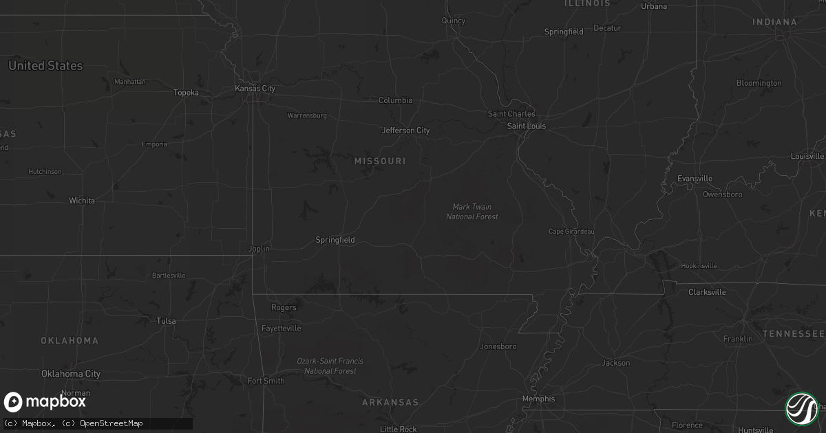
Hail Map in South Dakota on June 18, 2012
Get this storm
June 18 map
$229
one time, instant access
Download today. No call, no setup
Keep the $229
Bought the map and want the full workflow? Apply the entire $229 to a subscription within 7 days. None of it is wasted.
Every map, not just this one
This buys you this map. Subscription and you get every map we run, in the markets you choose from a few cities to whole states to nationwide. Plus real-time alerts the moment a storm fires.
Contact data
Name, contact info, occupancy, even credit band for addresses in the footprint. You go from where it hit to who to call.
Become the source they trust
Unlimited branding weather history reports on demand. You already have the documented answer ready for the property owner, and you are the one who showed up with it.
Property data and RoofTrace estimates
Pull up any address you have got, its value and the exact code rules for that jurisdiction, straight from One Click Code. Then RoofTrace estimates the squares, pitch, and roof value, priced the way you price.
Storm reports in South Dakota
South Dakota
| Date | Description |
|---|---|
| 06/18/20123:50 AM CDT | A local report indicates 1.00 inch wind near 9 W HECLA |
| 06/18/20123:24 AM CDT | Measured at watertown airport |
| 06/18/20123:20 AM CDT | Trees and branches down in watertown resulting in power outages |
| 06/18/20123:00 AM CDT | A local report indicates 1.50 inch wind near WALLACE |
| 06/18/20123:00 AM CDT | Hail size from dimes to half dollars |
| 06/18/20123:00 AM CDT | Dime sized hail fell for an estimated 20 to 30 minutes. Hail caused significant damage to corn. 3 to 4 inch diameter branches down as well. |
| 06/18/20122:55 AM CDT | Minor crop damage to corn and beans. |
| 06/18/20122:45 AM CDT | A local report indicates 1.75 inch wind near 1 NE WETONKA |
| 06/18/20121:18 AM CDT | Pea size hail and 1.5 inches of rain |
| 06/18/20121:07 AM CDT | A local report indicates 1.25 inch wind near WHITE |
| 06/18/201212:55 AM CDT | 1 foot diameter tree knocked down and several small branches stripped from tree |
| 06/18/201212:50 AM CDT | A local report indicates 1.25 inch wind near 7 N BROOKINGS |
| 06/18/201212:45 AM CDT | A local report indicates 3.00 inch wind near 2 N VOLGA |
| 06/18/201212:45 AM CDT | A local report indicates 1.00 inch wind near VOLGA |
| 06/18/201212:15 AM CDT | Hail in this area was golf ball to baseball size. |
| 06/18/201212:07 AM CDT | A local report indicates 1.00 inch wind near 2 NE LAKE PRESTON |
| 06/18/201212:06 AM CDT | Hail did significant damage to corn. |
| 06/18/201212:05 AM CDT | Several trees and large branches down in town. |
| 06/18/201212:05 AM CDT | A local report indicates 1.50 inch wind near 4 ENE DE SMET |
| 06/18/201212:00 AM CDT | Hail lasted approximately 25 minutes. Hail damage extended over 28 mile swath from 9 miles nw of de smet to 5 miles north of arlington sd. |
| 06/17/201211:41 PM CDT | Hail damaged plants in garden and flower bed. |
All States Impacted by Hail Map on June 18, 2012
Cities Impacted by Hail Map on June 18, 2012
- Dagmar, MT
- Mosinee, WI
- Ringle, WI
- Moran, MI
- Manistique, MI
- Marion, WI
- Clintonville, WI
- Poplar, MT
- Flaxville, MT
- Suring, WI
- Marinette, WI
- Coleman, WI
- Pound, WI
- Lena, WI
- Peshtigo, WI
- Russell, MN
- Marshall, MN
- Lynd, MN
- Laona, WI
- Crandon, WI
- Wabeno, WI
- Redstone, MT
- Erwin, SD
- Lake Preston, SD
- De Smet, SD
- Arlington, SD
- Stanley, WI
- Alma, WI
- Nelson, WI
- Willard, WI
- Augusta, WI
- Eleva, WI
- Fairchild, WI
- Mondovi, WI
- Osseo, WI
- Independence, WI
- Strum, WI
- Fall Creek, WI
- Larsen, WI
- Neenah, WI
- Schofield, WI
- Watertown, SD
- Lonsdale, MN
- Montgomery, MN
- Kilkenny, MN
- Northfield, MN
- Faribault, MN
- Dundas, MN
- New Prague, MN
- Jordan, MN
- Shakopee, MN
- Waupaca, WI
- Roscoe, SD
- Menomonie, WI
- Spencer, OH
- Sullivan, OH
- Homerville, OH
- Wellington, OH
- Roma, TX
- Williston, ND
- Webster, MN
- Elton, WI
- Bryant, WI
- Bowler, WI
- Antigo, WI
- White Lake, WI
- Maple City, MI
- Empire, MI
- Fairfax, MN
- Brandt, SD
- Clear Lake, SD
- Toronto, SD
- Bryant, SD
- Willow Lake, SD
- Volga, SD
- Brookings, SD
- Bruce, SD
- Medford, WI
- Escanaba, MI
- Gladstone, MI
- Hosmer, SD
- Eureka, SD
- Leola, SD
- Rudyard, MI
- Grenora, ND
- Bainville, MT
- Medicine Lake, MT
- Froid, MT
- Cogswell, ND
- Farmington, MN
- Lakeville, MN
- Elcho, WI
- Selby, SD
- Huron, OH
- Wakeman, OH
- Vermilion, OH
- Berlin Heights, OH
- Middleville, MI
- Spring Valley, WI
- Ellsworth, WI
- Elmwood, WI
- Plum City, WI
- Maiden Rock, WI
- Edgar, WI
- Marathon, WI
- Wausau, WI
- Traverse City, MI
- Colfax, WI
- Porterfield, WI
- Crivitz, WI
- Wallace, MI
- Menominee, MI
- Watertown, MN
- Waconia, MN
- Mayer, MN
- Athens, WI
- Rib Lake, WI
- Merrill, WI
- Frederick, SD
- Grenville, SD
- Webster, SD
- Newport, MI
- Eau Galle, WI
- New Town, ND
- Mandaree, ND
- Keene, ND
- Gulliver, MI
- Willmar, MN
- Tawas City, MI
- Goodhue, MN
- Red Wing, MN
- Wallace, SD
- Bradley, SD
- Brockton, MT
- Mount Crawford, VA
- Bridgewater, VA
- Wessington, SD
- Wolsey, SD
- Westport, SD
- Keshena, WI
- Williston, OH
- Martin, OH
- Genoa, OH
- Curtice, OH
- Millbury, OH
- Clay Center, OH
- Wayne, OH
- Fostoria, OH
- Bowling Green, OH
- Risingsun, OH
- Jerry City, OH
- Cygnet, OH
- Weston, OH
- Portage, OH
- Bloomdale, OH
- West Millgrove, OH
- Rudolph, OH
- Maumee, OH
- Holland, OH
- Monclova, OH
- Java, SD
- Ipswich, SD
- Bowdle, SD
- Barnard, SD
- Hecla, SD
- Oakes, ND
- Columbia, SD
- Cornell, MI
- Colby, WI
- Abbotsford, WI
- Tyler, MN
- Arco, MN
- Lake Benton, MN
- Greenwich, OH
- New London, OH
- Orr, MN
- Crane Lake, MN
- Custer, WI
- Iola, WI
- Amherst Junction, WI
- Beldenville, WI
- Balaton, MN
- Newberry, MI
- Naubinway, MI
- Trout Lake, MI
- Hitchcock, SD
- Bonduel, WI
- Black Creek, WI
- Shiocton, WI
- Nichols, WI
- Roscommon, MI
- Fife Lake, MI
- Grayling, MI
- Sleepy Eye, MN
- Redwood Falls, MN
- Morgan, MN
- Morton, MN
- Lafayette, MN
- Gibbon, MN
- Wabasso, MN
- Winthrop, MN
- Franklin, MN
- Galion, OH
- Pepin, WI
- Appleton, MN
- Correll, MN
- Madison, MN
- Bellingham, MN
- Saint Ignace, MI
- Cadillac, MI
- Aurora, SD
- Ruthton, MN
- Elkton, SD
- Interlochen, MI
- Grawn, MI
- Appleton, WI
- Fremont, WI
- Hortonville, WI
- Barryton, MI
- Sears, MI
- Veblen, SD
- Durand, WI
- Milbank, SD
- Saint Peter, MN
- Hendricks, MN
- Walnut Grove, MN
- Tracy, MN
- Renville, MN
- Estelline, SD
- Astoria, SD
- Bird Island, MN
- New Ulm, MN
- Minneota, MN
- Green Isle, MN
- Porter, MN
- Canby, MN
- Belview, MN
- Gaylord, MN
- Norwood Young America, MN
- Wood Lake, MN
- New Germany, MN
- Sacred Heart, MN
- Carpenter, SD
- Lester Prairie, MN
- Hector, MN
- Granite Falls, MN
- Young America, MN
- Stewart, MN
- Arlington, MN
- Glencoe, MN
- Clarkfield, MN
- Dawson, MN
- Plato, MN
- Clements, MN
- Lamberton, MN
- Gary, SD
- Iroquois, SD
- Castlewood, SD
- Yale, SD
- Cottonwood, MN
- Hamburg, MN
- Cologne, MN
- Henderson, MN
- Lucan, MN
- Hanley Falls, MN
- Lake Norden, SD
- Le Sueur, MN
- Danube, MN
- Saint Lawrence, SD
- Ivanhoe, MN
- Ghent, MN
- Huron, SD
- Hayti, SD
- Milroy, MN
- Seaforth, MN
- Boyd, MN
- Olivia, MN
- Badger, SD
- Vesta, MN
- White, SD
- Nicollet, MN
- Echo, MN
- Brownton, MN
- Raymond, SD
- Almond, WI
- Tulare, SD
- Roslyn, SD
- Gould City, MI
- Sault Sainte Marie, MI
- Kincheloe, MI
- Kinross, MI
- Rapid River, MI
- New Richmond, WI
- Mountain, WI
- Britton, SD
- Peever, SD
- Florence, SD
- Polk, OH
- Ashland, OH
- Saint Paul, MN
- Raymondville, TX
- Loyal, WI
- Owen, WI
- Curtiss, WI
- Unity, WI
- Stevens Point, WI
- Clark, SD
- Little Suamico, WI
- Abrams, WI
- Marvin, SD
- Garden City, SD
- Henry, SD
- Baileys Harbor, WI
- Stillwater, MN
- Bark River, MI
- Spalding, MI
- Daggett, MI
- Garden, MI
- Wilson, MI
- Perronville, MI
- Carney, MI
- Stephenson, MI
- Powers, MI
- Homestead, MT
- Oak Harbor, OH
- Collins, OH
- Norwalk, OH
- Oshkosh, WI
- Humbird, WI
- Wessington Springs, SD
- Bloomer, WI
- Grand Rapids, MI
- Birnamwood, WI
- Aniwa, WI
- Watford City, ND
- Dorchester, WI
- Stetsonville, WI
- Rosholt, WI
- Tigerton, WI
- Ogdensburg, WI
- Scandinavia, WI
- Amherst, WI
- Hastings, MN
- Falmouth, MI
- Merritt, MI
- Lake City, MI
- Walbridge, OH
- Perrysburg, OH
- Swanton, OH
- Neapolis, OH
- Kansas, OH
- Whitehouse, OH
- Tontogany, OH
- Haskins, OH
- Grand Rapids, OH
- Waterville, OH
- Liberty Center, OH
- Milton Center, OH
- Tiffin, OH
- Custar, OH
- McClure, OH
- North Baltimore, OH
- Cannon Falls, MN
- Algoma, WI
- Sturgeon Bay, WI
- Sheboygan, WI
- Belle Plaine, MN
- Carver, MN
- Onsted, MI
- Adrian, MI
- Tipton, MI
- Havana, ND
- Forman, ND
- Cayuga, ND
- Rutland, ND
- Lidgerwood, ND
- Grand Marais, MN
- New Effington, SD
- Chippewa Falls, WI
- Newton, WI
- Cleveland, WI
- Withee, WI
- Reserve, MT
- Hager City, WI
- Prescott, WI
- Cosmos, MN
- Millersburg, OH
- Killbuck, OH
- Kiel, WI
- Valders, WI
- Whitelaw, WI
- Manitowoc, WI
- Eau Claire, WI
- West Alexander, PA
- Doland, SD
- Deerbrook, WI
- Le Center, MN
- Hatley, WI
- Eland, WI
- Brussels, WI
- Oconto, WI
- Callands, VA
- Chatham, VA
- Welch, MN
- Hampton, MN
- Randolph, MN
- Brillion, WI
- Weyauwega, WI
- Elk Mound, WI
- Arkansaw, WI
- Boyd, WI
- Cornell, WI
- Thorp, WI
- Lublin, WI
- Gilman, WI
- Gleason, WI
- Irma, WI
- Ortley, SD
- Waubay, SD
- Dugspur, VA
- Hillsville, VA
- Fremont, MI
- Lake City, MN
- Stockholm, WI
- Wilmot, SD
- Houlton, WI
- Bayport, MN
- Hudson, WI
- Vermillion, MN
- Elko New Market, MN
- Kenyon, MN
- Prior Lake, MN
- Rosemount, MN
- Nerstrand, MN
- Dennison, MN
- Bay City, WI
- Cottage Grove, MN
- River Falls, WI
- Afton, MN
- South Shore, SD
- Cedar, MI
- Fish Creek, WI
- Eden, SD
- Somerset, WI
- Lake Elmo, MN
- Chaska, MN
- Chanhassen, MN
- Excelsior, MN
- Galax, VA
- Mattoon, WI
- Lakeland, MN
- Willernie, MN
- Killdeer, ND
- New London, WI
- Allendale, MI
- Marne, MI
- Coopersville, MI
- Pickford, MI
- Concepcion, TX
- Independence, VA
- Neopit, WI
- Pearson, WI
- Jim Falls, WI
- Cadott, WI
- Summit Lake, WI
- Rothschild, WI
- Tomahawk, WI
- Gresham, WI
- Brokaw, WI
- Greenwood, WI
- Athelstane, WI
- Pickerel, WI
- Stratford, WI
- Spencer, WI
- Aberdeen, SD
- Vienna, SD
- Hazel, SD
- Marshfield, WI
- Lowell, MI
- Delton, MI
- Ada, MI
- Shelbyville, MI
- Wayland, MI
- Alto, MI
- Caledonia, MI
- Hastings, MI
- Kabetogama, MN
- Littlefork, MN
- Rio Grande City, TX
- Coshocton, OH
- West Salem, OH
- Jeromesville, OH
- Wooster, OH
- Dayton, VA
- Plainfield, WI
- Bancroft, WI
- Malone, WI
- Chilton, WI
- Blomkest, MN
- Lake Lillian, MN
- Roseglen, ND
- Boyceville, WI
- Knapp, WI
- Pemberville, OH
- Shreve, OH
- Big Prairie, OH
- Amherst, OH
- Kingsley, MI
- Reedsville, WI
- Hopkins, MI
- Eagle Butte, SD
- Premont, TX
- Amberg, WI
- Benson, MN
- Weyers Cave, VA
- Realitos, TX
- Monroeville, OH
- Montague, MI
- Whitehall, MI
- Whitehall, WI
- Blair, WI
- Hixton, WI
- Milan, OH
- Forestville, WI
- Claremont, SD
- Houghton, SD
- Krakow, WI
- Gettysburg, SD
- Ellendale, ND
- Minneapolis, MN
- Greenleaf, WI
- Warsaw, OH
- Odessa, MN
- Hinton, VA
- Ellison Bay, WI
- Hilbert, WI
- Wild Rose, WI
- Berlin, WI
- Menasha, WI
- Kaukauna, WI
- Winneconne, WI
- Pine River, WI
- Butte Des Morts, WI
- Stockbridge, WI
- Sherwood, WI
- Omro, WI
- Poy Sippi, WI
- Dupree, SD
- Barbeau, MI
- Wells, MI
- Engadine, MI
- Dafter, MI
- Nahma, MI
- Ravenna, MI
- Muskegon, MI
- Twin Brooks, SD
- Holcombe, WI
- Claysville, PA
- Atwater, MN
- Osseo, MN
- Maple Grove, MN
- Woodville, OH
- Luckey, OH
- Wheaton, MN
- Summit, SD
- Beulah, MI
- Buckley, MI
- Montevideo, MN
- Attica, OH
- Alma Center, WI
- Two Rivers, WI
- Freeport, MI
- Elmore, OH
- Pulaski, WI
- Oconto Falls, WI
- Sobieski, WI
- Manawa, WI
- San Diego, TX
- Gillett, WI
- Twin Lake, MI
- International Falls, MN
- Lake Ann, MI
- Kandiyohi, MN
- Altoona, WI
- Hutchinson, MN
- Dassel, MN
- Silver Lake, MN
- Cokato, MN
- Bailey, MI
- Grant, MI
- Conklin, MI
- Corona, SD
- Elkhart Lake, WI
- Neillsville, WI
- Inver Grove Heights, MN
- South Saint Paul, MN
- Thompsonville, MI
- Honor, MI
- Grand Haven, MI
- Sparta, MI
- Comstock Park, MI
- Sand Lake, MI
- Litchfield, MN
- Grove City, MN
- Hessel, MI
- Hewitt, WI
- Chili, WI
- Saint Paul Park, MN
- Newport, MN
- Cleveland, MN
- Frontenac, MN
- Sisseton, SD
- Ringgold, VA
- Kennan, WI
- Roberts, WI
- Manitou Beach, MI
- Tecumseh, MI
- Brooklyn, MI
- Nova, OH
- Kimball, SD
- Rock, MI
- Brantwood, WI
- Vulcan, MI
- Hopkins, MN
- Minnetonka, MN
- Eden Prairie, MN
- Traphill, NC
- Wausaukee, WI
- Kewaunee, WI
- Miller, SD
- Holton, MI
- Hermansville, MI
- Maple Plain, MN
- Victoria, MN
- Saint Bonifacius, MN
- Mound, MN
- Egg Harbor, WI
- Sister Bay, WI


