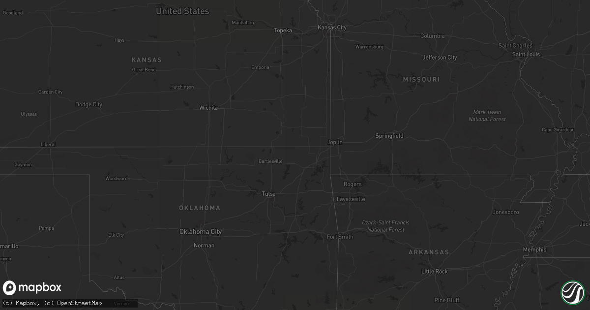
Hail Map on June 18, 2012
Get this storm
June 18 map
$229
one time, instant access
Download today. No call, no setup
Keep the $229
Bought the map and want the full workflow? Apply the entire $229 to a subscription within 7 days. None of it is wasted.
Every map, not just this one
This buys you this map. Subscription and you get every map we run, in the markets you choose from a few cities to whole states to nationwide. Plus real-time alerts the moment a storm fires.
Contact data
Name, contact info, occupancy, even credit band for addresses in the footprint. You go from where it hit to who to call.
Become the source they trust
Unlimited branding weather history reports on demand. You already have the documented answer ready for the property owner, and you are the one who showed up with it.
Property data and RoofTrace estimates
Pull up any address you have got, its value and the exact code rules for that jurisdiction, straight from One Click Code. Then RoofTrace estimates the squares, pitch, and roof value, priced the way you price.
States Impacted by Hail Map on June 18, 2012
Storm reports
Ohio
| Date | Description |
|---|---|
| 06/18/20125:20 PM CDT | Tree down on i-77 near mile marker 74. |
| 06/18/20125:10 PM CDT | Tree down on schilling hill road between dover and sugarcreek. |
| 06/18/20125:10 PM CDT | Trees down on route 146... County road 10... And county road 271 |
| 06/18/20125:02 PM CDT | Tree down on state route 93 |
| 06/18/20124:45 PM CDT | Trees down. |
| 06/18/20124:25 PM CDT | A local report indicates 68 MPH wind near BERLIN |
| 06/18/20124:20 PM CDT | Numerous trees and limbs down across the county. Two roads closed because of downed trees. |
| 06/18/20124:00 PM CDT | Tree down. |
| 06/18/20123:40 PM CDT | Tree down. |
| 06/18/20123:10 PM CDT | Large limbs down in the road. |
| 06/18/20123:05 PM CDT | Four trees down across the county. |
| 06/18/20123:05 PM CDT | A few limbs down on 301. |
| 06/18/20123:05 PM CDT | One tree down on 162. |
| 06/18/20123:05 PM CDT | One tree down on route 42. |
| 06/18/20122:50 PM CDT | Numerous trees and powerlines down over the western portion of the county. |
| 06/18/20122:50 PM CDT | Powerpoles and lines down. |
| 06/18/20122:41 PM CDT | A local report indicates 70 MPH wind near WAKEMAN |
| 06/18/20122:26 PM CDT | A local report indicates 60 MPH wind near BERLIN HEIGHTS |
| 06/18/20122:25 PM CDT | Tree down. |
| 06/18/20122:15 PM CDT | A local report indicates 60 MPH wind near NORWALK |
| 06/18/20122:15 PM CDT | Numerous powerpoles down. Reported by police dept via media. |
| 06/18/20122:13 PM CDT | A local report indicates 60 MPH wind near NORWALK |
| 06/18/20122:03 PM CDT | Large limbs down. |
| 06/18/20121:55 PM CDT | A local report indicates 1.25 inch wind near 2 S BOWLING GREEN |
| 06/18/20121:50 PM CDT | Large limbs down across the county. |
| 06/18/20121:45 PM CDT | One tree down on rudolph road...near rudolph. |
| 06/18/20121:40 PM CDT | Large limbs down. |
| 06/18/20121:20 PM CDT | A couple of trees down. |
| 06/18/20121:20 PM CDT | Grape size. |
| 06/18/20121:15 PM CDT | Tree down on route 28 and strayer. |
North Dakota
| Date | Description |
|---|---|
| 06/18/20126:54 PM CDT | Spotter estimated 60 mph winds. |
| 06/18/20126:54 PM CDT | Ground covered with hail. Hailed for past 5 minutes and still hailing. |
| 06/17/20127:30 PM CDT | A local report indicates 1.00 inch wind near 1 NW KEENE |
| 06/17/20127:18 PM CDT | A local report indicates 1.00 inch wind near 14 W CHARLSON |
| 06/17/20127:09 PM CDT | Hail started as dime and got to golfballs... With high winds reported. |
| 06/17/20127:03 PM CDT | A local report indicates 60 MPH wind near 2 NNW WILLISTON |
| 06/17/20127:03 PM CDT | Relayed by media. 1.25 of rainfall. |
Michigan
| Date | Description |
|---|---|
| 06/18/20126:54 PM CDT | Two 6 inch diameter trees down on m 37 near chateau grand traverse. |
| 06/18/20123:21 PM CDT | Dime to quarter size at 18896 s mackinac trail. |
| 06/18/20122:35 PM CDT | On the north side of gladstone. Most hail stones were dime to quarter sized. |
| 06/18/20122:30 PM CDT | Golf ball sized hail. Just stopped. Not much wind. |
| 06/18/201212:19 PM CDT | Powerlines reported down. |
| 06/18/201212:15 PM CDT | Grosse ile bridge closed due to wind damage. |
| 06/18/201212:13 PM CDT | Trees and powerlines downed |
| 06/18/201211:56 AM CDT | A local report indicates 59 MPH wind near ROMULUS |
| 06/18/201211:38 AM CDT | Trees and powerlines downed |
| 06/18/20129:40 AM CDT | Small tree downed at wooodbury rd. And doyle rd. |
| 06/18/20129:05 AM CDT | 3 foot dia tree down on ware rd between montcalm rd and conklin rd. |
| 06/18/20128:50 AM CDT | Tree fell on car at cascade and cherry dr. Person pinned in car. |
| 06/17/20128:45 PM CDT | Trees down in city. Roof damage to two downtown buildings. Time estimated by radar. |
| 06/17/20128:30 PM CDT | Tree uprooted. Delayed report from monday night. |
| 06/17/20127:10 PM CDT | Red cardinal lane and adam lane off blair town hall road. Windows blown out of house...antenna blew off roof...uprooted very large maple tree...roof damage...fences blo |
Wisconsin
| Date | Description |
|---|---|
| 06/18/20125:26 PM CDT | A local report indicates 1.00 inch wind near 2 E MENASHA |
| 06/18/20125:20 PM CDT | A local report indicates 1.00 inch wind near 2 S APPLETON |
| 06/18/20125:19 PM CDT | A local report indicates 1.00 inch wind near MENASHA |
| 06/18/20125:18 PM CDT | A local report indicates 1.25 inch wind near NEENAH |
| 06/18/20125:15 PM CDT | A local report indicates 1.25 inch wind near NEENAH |
| 06/18/20125:12 PM CDT | A local report indicates 1.25 inch wind near NEENAH |
| 06/18/20125:04 PM CDT | Near intersection of hwy 45 and hwy 10 |
| 06/18/20124:40 PM CDT | Camper trailer destroyed. Delayed report |
| 06/18/20124:28 PM CDT | A local report indicates 1.50 inch wind near PESHTIGO |
| 06/18/20124:10 PM CDT | A local report indicates 1.00 inch wind near CLINTONVILLE |
| 06/18/20124:09 PM CDT | A local report indicates 1.00 inch wind near KING |
| 06/18/20124:09 PM CDT | A local report indicates 1.25 inch wind near CLINTONVILLE |
| 06/18/20123:08 PM CDT | A local report indicates 1.25 inch wind near BROKAW |
| 06/18/20122:45 PM CDT | A local report indicates 1.75 inch wind near SUMMIT LAKE |
| 06/18/20122:27 PM CDT | 42 mph wind gust |
| 06/18/20122:25 PM CDT | A local report indicates 1.00 inch wind near 3 E COLBY |
| 06/18/20122:22 PM CDT | A local report indicates 1.75 inch wind near COLBY |
| 06/18/20122:21 PM CDT | Just larger than a quarter. |
| 06/18/20122:20 PM CDT | Time estimated |
| 06/18/20126:55 AM CDT | Numerous large pine trees down. One tree knocked out powerline. |
| 06/18/20126:35 AM CDT | Numerious large trees down north of city on hwy 45 and county rd aa |
| 06/18/20126:30 AM CDT | 16 inch tree snapped in half. Relayed by wsaw. |
| 06/18/20126:15 AM CDT | Downed barn and damaged garden on east side of wausau off of hwy z. Relayed by wsaw. |
| 06/18/20126:10 AM CDT | Trees down |
| 06/18/20126:10 AM CDT | Trees down-time approximate |
| 06/18/20125:50 AM CDT | Powerlines down. Time estimated. |
| 06/18/20125:40 AM CDT | Small tree down. Time estimated. |
| 06/18/20125:40 AM CDT | Trees down at intersection of hwy 97 and county hwy f |
| 06/18/20125:28 AM CDT | Corrected for time and wind gust |
| 06/18/20125:25 AM CDT | Tree down on house |
| 06/18/20125:21 AM CDT | A few trees down. Scattered power outages in stetsonville. |
| 06/18/20124:38 AM CDT | A local report indicates 1.25 inch wind near PRESCOTT |
Minnesota
| Date | Description |
|---|---|
| 06/18/20126:51 AM CDT | Several two to three inch diameter branches severed and several trees down near intersection of hwy 13 and 150th st. |
| 06/18/20126:30 AM CDT | Quarter to ping pong ball sized hail reported near intersection of orleans and harriet. |
| 06/18/20126:22 AM CDT | A local report indicates 1.00 inch wind near 2 SW STILLWATER |
| 06/18/20126:20 AM CDT | Reported near intersection of lake elmo ave and hwy 5. Time estimated. |
| 06/18/20125:55 AM CDT | A local report indicates 1.00 inch wind near VADNAIS HEIGHTS |
| 06/18/20124:35 AM CDT | 1 ft diameter tree downed near intersection of bailey road and radio drive. Time estimated. |
| 06/18/20124:33 AM CDT | Reported at stanton airfield |
| 06/18/20124:30 AM CDT | 18 inch diameter tree uprooted. |
| 06/18/20124:30 AM CDT | 2 ft diameter tree downed in southeast st. Paul near maplewood border. Time estimated. |
| 06/18/20124:29 AM CDT | Reported at st paul downtown airport |
| 06/18/20124:25 AM CDT | Large trees down. Road to neighborhood blocked near intersection of hwy 494 and co rd 56. Time estimated. |
| 06/18/20124:25 AM CDT | Large tree limbs snapped in half. Small trees down. Time estimated. Media also reporting utility poles down in south st paul near interstate 494. |
| 06/18/20124:25 AM CDT | A local report indicates 1.00 inch wind near DUNDAS |
| 06/18/20124:23 AM CDT | 30 ft tall pine tree uprooted. Branches broken off other trees. |
| 06/18/20124:21 AM CDT | Leaves shredded. Lasted for 7 minutes. |
| 06/18/20124:20 AM CDT | Fifty five inch diameter oak tree snapped off above main stump. Main stump 150 inches in diameter at the base. Damage occurred on italy path. |
| 06/18/20124:15 AM CDT | 30 ft tree down. Wood fence blown over. Near intersection of shannon parkway and hwy 46. Time estimated by radar. |
| 06/18/20124:10 AM CDT | 10 inch diameter tree downed |
| 06/18/20124:10 AM CDT | 14 power poles knocked down or snapped in half along pilot knob road between county rd 42 and county road 46...closing road. Time estimated. |
| 06/18/20124:05 AM CDT | Tree down on knox between 82nd and american blvd. Tin shed blown to next yard near 100 st. Time estimated. |
| 06/18/20124:05 AM CDT | Several trees down on bursville parkway at hwy 35w. Time estimated. |
| 06/18/20124:03 AM CDT | A local report indicates 60 MPH wind near PRIOR LAKE |
| 06/18/20124:00 AM CDT | Numerous large trees downed. Time corrected. |
| 06/18/20124:00 AM CDT | Aprswxnet sensor. Time estimated. |
| 06/18/20124:00 AM CDT | Several trees down at intersection of hwy 13 and 150th st. |
| 06/18/20123:59 AM CDT | Measured by spotter at co rd 2 and 21. Reported by emergency manager. |
| 06/18/20123:55 AM CDT | A local report indicates 83 MPH wind near BELLE PLAINE |
| 06/18/20123:55 AM CDT | A local report indicates 1.00 inch wind near BELLE PLAINE |
| 06/18/20123:55 AM CDT | 50 to 60 trees down. Power lines down. |
| 06/18/20123:55 AM CDT | A local report indicates 1.00 inch wind near LE SUEUR |
| 06/18/20123:52 AM CDT | Mndot road sensor |
| 06/18/20123:48 AM CDT | Six to eight inch tree limbs severed. Telephone pole leaning against tree. |
| 06/18/20123:45 AM CDT | Numerous medium to large maple...oak and pine trees toppled. Some trees over two feet in diameter. At least 30 trees felled with numerous six inch diameter or slightly |
| 06/18/20123:35 AM CDT | Large tree on house. Time estimated by radar. |
| 06/18/20123:30 AM CDT | Enough hail to make the ground white |
| 06/18/20123:20 AM CDT | Numerous large trees downed |
| 06/18/20122:15 AM CDT | Minor damage to corn. |
| 06/18/20122:05 AM CDT | A local report indicates 60 MPH wind near 6 S MARSHALL |
| 06/18/20122:05 AM CDT | Hail was accompanied by 50 to 60 mph winds. Some damage to crops. |
| 06/18/20122:01 AM CDT | Damage to camper from hail. |
| 06/18/20121:57 AM CDT | A local report indicates 2.00 inch wind near 3 NE RUSSELL |
| 06/18/20121:55 AM CDT | Windows broken out...roof damaged and vehicles damaged by hail. |
| 06/18/20121:55 AM CDT | A local report indicates 1.75 inch wind near RUSSELL |
| 06/18/20121:54 AM CDT | A local report indicates 60 MPH wind near 3 SE RUSSELL |
| 06/18/20121:54 AM CDT | A local report indicates 1.50 inch wind near 1 E RUSSELL |
| 06/18/20121:50 AM CDT | A local report indicates 1.00 inch wind near RUSSELL |
| 06/18/20121:48 AM CDT | A local report indicates 1.00 inch wind near 3 WNW RUSSELL |
| 06/18/20121:37 AM CDT | A local report indicates 1.50 inch wind near 3 SW ARCO |
South Dakota
| Date | Description |
|---|---|
| 06/18/20123:50 AM CDT | A local report indicates 1.00 inch wind near 9 W HECLA |
| 06/18/20123:24 AM CDT | Measured at watertown airport |
| 06/18/20123:20 AM CDT | Trees and branches down in watertown resulting in power outages |
| 06/18/20123:00 AM CDT | A local report indicates 1.50 inch wind near WALLACE |
| 06/18/20123:00 AM CDT | Dime sized hail fell for an estimated 20 to 30 minutes. Hail caused significant damage to corn. 3 to 4 inch diameter branches down as well. |
| 06/18/20123:00 AM CDT | Hail size from dimes to half dollars |
| 06/18/20122:55 AM CDT | Minor crop damage to corn and beans. |
| 06/18/20122:45 AM CDT | A local report indicates 1.75 inch wind near 1 NE WETONKA |
| 06/18/20121:18 AM CDT | Pea size hail and 1.5 inches of rain |
| 06/18/20121:07 AM CDT | A local report indicates 1.25 inch wind near WHITE |
| 06/18/201212:55 AM CDT | 1 foot diameter tree knocked down and several small branches stripped from tree |
| 06/18/201212:50 AM CDT | A local report indicates 1.25 inch wind near 7 N BROOKINGS |
| 06/18/201212:45 AM CDT | A local report indicates 1.00 inch wind near VOLGA |
| 06/18/201212:45 AM CDT | A local report indicates 3.00 inch wind near 2 N VOLGA |
| 06/18/201212:15 AM CDT | Hail in this area was golf ball to baseball size. |
| 06/18/201212:07 AM CDT | A local report indicates 1.00 inch wind near 2 NE LAKE PRESTON |
| 06/18/201212:06 AM CDT | Hail did significant damage to corn. |
| 06/18/201212:05 AM CDT | A local report indicates 1.50 inch wind near 4 ENE DE SMET |
| 06/18/201212:05 AM CDT | Several trees and large branches down in town. |
| 06/18/201212:00 AM CDT | Hail lasted approximately 25 minutes. Hail damage extended over 28 mile swath from 9 miles nw of de smet to 5 miles north of arlington sd. |
| 06/17/201211:41 PM CDT | Hail damaged plants in garden and flower bed. |
North Carolina
| Date | Description |
|---|---|
| 06/18/20125:18 PM CDT | Several large tree limbs and one tree blown down at the stone mountain golf club. |
Virginia
| Date | Description |
|---|---|
| 06/18/20124:46 PM CDT | Relayed by public along main street in mount crawford |
| 06/18/20124:45 PM CDT | Healthy walnut tree had 6-10 inch limbs snapped. Plywood roof panel removed from shed. Ventilator ripped from roof of garage. A-frame swing set blown across neighboring |
| 06/18/20124:42 PM CDT | Siding peeled from house. Trees and limbs down. Hail also occurred but size was unobserved. |
| 06/18/20124:41 PM CDT | Limbs down from thunderstorm wind |
| 06/18/20124:30 PM CDT | A local report indicates 1.00 inch wind near BRIDGEWATER |
| 06/18/20124:14 PM CDT | Hail damaged corn crop. Lasted several minutes. |
| 06/18/20124:10 PM CDT | Large trees and limbs down from thunderstorm wind |
| 06/18/20123:08 PM CDT | Several large tree limbs down on north briar mountain road. |
| 06/18/201212:42 PM CDT | Tree down on carlos drive |
| 06/18/201212:42 PM CDT | Tree down on valley view blvd |
Pennsylvania
| Date | Description |
|---|---|
| 06/18/20124:45 PM CDT | Trees down. |
Cities Impacted by Hail Map on June 18, 2012
- Dagmar, MT
- Mosinee, WI
- Ringle, WI
- Moran, MI
- Manistique, MI
- Marion, WI
- Clintonville, WI
- Poplar, MT
- Flaxville, MT
- Suring, WI
- Marinette, WI
- Coleman, WI
- Pound, WI
- Lena, WI
- Peshtigo, WI
- Russell, MN
- Marshall, MN
- Lynd, MN
- Laona, WI
- Crandon, WI
- Wabeno, WI
- Redstone, MT
- Erwin, SD
- Lake Preston, SD
- De Smet, SD
- Arlington, SD
- Stanley, WI
- Alma, WI
- Nelson, WI
- Willard, WI
- Augusta, WI
- Eleva, WI
- Fairchild, WI
- Mondovi, WI
- Osseo, WI
- Independence, WI
- Strum, WI
- Fall Creek, WI
- Larsen, WI
- Neenah, WI
- Schofield, WI
- Watertown, SD
- Lonsdale, MN
- Montgomery, MN
- Kilkenny, MN
- Northfield, MN
- Faribault, MN
- Dundas, MN
- New Prague, MN
- Jordan, MN
- Shakopee, MN
- Waupaca, WI
- Roscoe, SD
- Menomonie, WI
- Spencer, OH
- Sullivan, OH
- Homerville, OH
- Wellington, OH
- Roma, TX
- Williston, ND
- Webster, MN
- Elton, WI
- Bryant, WI
- Bowler, WI
- Antigo, WI
- White Lake, WI
- Maple City, MI
- Empire, MI
- Fairfax, MN
- Brandt, SD
- Clear Lake, SD
- Toronto, SD
- Bryant, SD
- Willow Lake, SD
- Volga, SD
- Brookings, SD
- Bruce, SD
- Medford, WI
- Escanaba, MI
- Gladstone, MI
- Hosmer, SD
- Eureka, SD
- Leola, SD
- Rudyard, MI
- Grenora, ND
- Bainville, MT
- Medicine Lake, MT
- Froid, MT
- Cogswell, ND
- Farmington, MN
- Lakeville, MN
- Elcho, WI
- Selby, SD
- Huron, OH
- Wakeman, OH
- Vermilion, OH
- Berlin Heights, OH
- Middleville, MI
- Spring Valley, WI
- Ellsworth, WI
- Elmwood, WI
- Plum City, WI
- Maiden Rock, WI
- Edgar, WI
- Marathon, WI
- Wausau, WI
- Traverse City, MI
- Colfax, WI
- Porterfield, WI
- Crivitz, WI
- Wallace, MI
- Menominee, MI
- Watertown, MN
- Waconia, MN
- Mayer, MN
- Athens, WI
- Rib Lake, WI
- Merrill, WI
- Frederick, SD
- Grenville, SD
- Webster, SD
- Newport, MI
- Eau Galle, WI
- New Town, ND
- Mandaree, ND
- Keene, ND
- Gulliver, MI
- Willmar, MN
- Tawas City, MI
- Goodhue, MN
- Red Wing, MN
- Wallace, SD
- Bradley, SD
- Brockton, MT
- Mount Crawford, VA
- Bridgewater, VA
- Wessington, SD
- Wolsey, SD
- Westport, SD
- Keshena, WI
- Williston, OH
- Martin, OH
- Genoa, OH
- Curtice, OH
- Millbury, OH
- Clay Center, OH
- Wayne, OH
- Fostoria, OH
- Bowling Green, OH
- Risingsun, OH
- Jerry City, OH
- Cygnet, OH
- Weston, OH
- Portage, OH
- Bloomdale, OH
- West Millgrove, OH
- Rudolph, OH
- Maumee, OH
- Holland, OH
- Monclova, OH
- Java, SD
- Ipswich, SD
- Bowdle, SD
- Barnard, SD
- Hecla, SD
- Oakes, ND
- Columbia, SD
- Cornell, MI
- Colby, WI
- Abbotsford, WI
- Tyler, MN
- Arco, MN
- Lake Benton, MN
- Greenwich, OH
- New London, OH
- Orr, MN
- Crane Lake, MN
- Custer, WI
- Iola, WI
- Amherst Junction, WI
- Beldenville, WI
- Balaton, MN
- Newberry, MI
- Naubinway, MI
- Trout Lake, MI
- Hitchcock, SD
- Bonduel, WI
- Black Creek, WI
- Shiocton, WI
- Nichols, WI
- Roscommon, MI
- Fife Lake, MI
- Grayling, MI
- Sleepy Eye, MN
- Redwood Falls, MN
- Morgan, MN
- Morton, MN
- Lafayette, MN
- Gibbon, MN
- Wabasso, MN
- Winthrop, MN
- Franklin, MN
- Galion, OH
- Pepin, WI
- Appleton, MN
- Correll, MN
- Madison, MN
- Bellingham, MN
- Saint Ignace, MI
- Cadillac, MI
- Aurora, SD
- Ruthton, MN
- Elkton, SD
- Interlochen, MI
- Grawn, MI
- Appleton, WI
- Fremont, WI
- Hortonville, WI
- Barryton, MI
- Sears, MI
- Veblen, SD
- Durand, WI
- Milbank, SD
- Saint Peter, MN
- Hendricks, MN
- Walnut Grove, MN
- Tracy, MN
- Renville, MN
- Estelline, SD
- Astoria, SD
- Bird Island, MN
- New Ulm, MN
- Minneota, MN
- Green Isle, MN
- Porter, MN
- Canby, MN
- Belview, MN
- Gaylord, MN
- Norwood Young America, MN
- Wood Lake, MN
- New Germany, MN
- Sacred Heart, MN
- Carpenter, SD
- Lester Prairie, MN
- Hector, MN
- Granite Falls, MN
- Young America, MN
- Stewart, MN
- Arlington, MN
- Glencoe, MN
- Clarkfield, MN
- Dawson, MN
- Plato, MN
- Clements, MN
- Lamberton, MN
- Gary, SD
- Iroquois, SD
- Castlewood, SD
- Yale, SD
- Cottonwood, MN
- Hamburg, MN
- Cologne, MN
- Henderson, MN
- Lucan, MN
- Hanley Falls, MN
- Lake Norden, SD
- Le Sueur, MN
- Danube, MN
- Saint Lawrence, SD
- Ivanhoe, MN
- Ghent, MN
- Huron, SD
- Hayti, SD
- Milroy, MN
- Seaforth, MN
- Boyd, MN
- Olivia, MN
- Badger, SD
- Vesta, MN
- White, SD
- Nicollet, MN
- Echo, MN
- Brownton, MN
- Raymond, SD
- Almond, WI
- Tulare, SD
- Roslyn, SD
- Gould City, MI
- Sault Sainte Marie, MI
- Kincheloe, MI
- Kinross, MI
- Rapid River, MI
- New Richmond, WI
- Mountain, WI
- Britton, SD
- Peever, SD
- Florence, SD
- Polk, OH
- Ashland, OH
- Saint Paul, MN
- Raymondville, TX
- Loyal, WI
- Owen, WI
- Curtiss, WI
- Unity, WI
- Stevens Point, WI
- Clark, SD
- Little Suamico, WI
- Abrams, WI
- Marvin, SD
- Garden City, SD
- Henry, SD
- Baileys Harbor, WI
- Stillwater, MN
- Bark River, MI
- Spalding, MI
- Daggett, MI
- Garden, MI
- Wilson, MI
- Perronville, MI
- Carney, MI
- Stephenson, MI
- Powers, MI
- Homestead, MT
- Oak Harbor, OH
- Collins, OH
- Norwalk, OH
- Oshkosh, WI
- Humbird, WI
- Wessington Springs, SD
- Bloomer, WI
- Grand Rapids, MI
- Birnamwood, WI
- Aniwa, WI
- Watford City, ND
- Dorchester, WI
- Stetsonville, WI
- Rosholt, WI
- Tigerton, WI
- Ogdensburg, WI
- Scandinavia, WI
- Amherst, WI
- Hastings, MN
- Falmouth, MI
- Merritt, MI
- Lake City, MI
- Walbridge, OH
- Perrysburg, OH
- Swanton, OH
- Neapolis, OH
- Kansas, OH
- Whitehouse, OH
- Tontogany, OH
- Haskins, OH
- Grand Rapids, OH
- Waterville, OH
- Liberty Center, OH
- Milton Center, OH
- Tiffin, OH
- Custar, OH
- McClure, OH
- North Baltimore, OH
- Cannon Falls, MN
- Algoma, WI
- Sturgeon Bay, WI
- Sheboygan, WI
- Belle Plaine, MN
- Carver, MN
- Onsted, MI
- Adrian, MI
- Tipton, MI
- Havana, ND
- Forman, ND
- Cayuga, ND
- Rutland, ND
- Lidgerwood, ND
- Grand Marais, MN
- New Effington, SD
- Chippewa Falls, WI
- Newton, WI
- Cleveland, WI
- Withee, WI
- Reserve, MT
- Hager City, WI
- Prescott, WI
- Cosmos, MN
- Millersburg, OH
- Killbuck, OH
- Kiel, WI
- Valders, WI
- Whitelaw, WI
- Manitowoc, WI
- Eau Claire, WI
- West Alexander, PA
- Doland, SD
- Deerbrook, WI
- Le Center, MN
- Hatley, WI
- Eland, WI
- Brussels, WI
- Oconto, WI
- Callands, VA
- Chatham, VA
- Welch, MN
- Hampton, MN
- Randolph, MN
- Brillion, WI
- Weyauwega, WI
- Elk Mound, WI
- Arkansaw, WI
- Boyd, WI
- Cornell, WI
- Thorp, WI
- Lublin, WI
- Gilman, WI
- Gleason, WI
- Irma, WI
- Ortley, SD
- Waubay, SD
- Dugspur, VA
- Hillsville, VA
- Fremont, MI
- Lake City, MN
- Stockholm, WI
- Wilmot, SD
- Houlton, WI
- Bayport, MN
- Hudson, WI
- Vermillion, MN
- Elko New Market, MN
- Kenyon, MN
- Prior Lake, MN
- Rosemount, MN
- Nerstrand, MN
- Dennison, MN
- Bay City, WI
- Cottage Grove, MN
- River Falls, WI
- Afton, MN
- South Shore, SD
- Cedar, MI
- Fish Creek, WI
- Eden, SD
- Somerset, WI
- Lake Elmo, MN
- Chaska, MN
- Chanhassen, MN
- Excelsior, MN
- Galax, VA
- Mattoon, WI
- Lakeland, MN
- Willernie, MN
- Killdeer, ND
- New London, WI
- Allendale, MI
- Marne, MI
- Coopersville, MI
- Pickford, MI
- Concepcion, TX
- Independence, VA
- Neopit, WI
- Pearson, WI
- Jim Falls, WI
- Cadott, WI
- Summit Lake, WI
- Rothschild, WI
- Tomahawk, WI
- Gresham, WI
- Brokaw, WI
- Greenwood, WI
- Athelstane, WI
- Pickerel, WI
- Stratford, WI
- Spencer, WI
- Aberdeen, SD
- Vienna, SD
- Hazel, SD
- Marshfield, WI
- Lowell, MI
- Delton, MI
- Ada, MI
- Shelbyville, MI
- Wayland, MI
- Alto, MI
- Caledonia, MI
- Hastings, MI
- Kabetogama, MN
- Littlefork, MN
- Rio Grande City, TX
- Coshocton, OH
- West Salem, OH
- Jeromesville, OH
- Wooster, OH
- Dayton, VA
- Plainfield, WI
- Bancroft, WI
- Malone, WI
- Chilton, WI
- Blomkest, MN
- Lake Lillian, MN
- Roseglen, ND
- Boyceville, WI
- Knapp, WI
- Pemberville, OH
- Shreve, OH
- Big Prairie, OH
- Amherst, OH
- Kingsley, MI
- Reedsville, WI
- Hopkins, MI
- Eagle Butte, SD
- Premont, TX
- Amberg, WI
- Benson, MN
- Weyers Cave, VA
- Realitos, TX
- Monroeville, OH
- Montague, MI
- Whitehall, MI
- Whitehall, WI
- Blair, WI
- Hixton, WI
- Milan, OH
- Forestville, WI
- Claremont, SD
- Houghton, SD
- Krakow, WI
- Gettysburg, SD
- Ellendale, ND
- Minneapolis, MN
- Greenleaf, WI
- Warsaw, OH
- Odessa, MN
- Hinton, VA
- Ellison Bay, WI
- Hilbert, WI
- Wild Rose, WI
- Berlin, WI
- Menasha, WI
- Kaukauna, WI
- Winneconne, WI
- Pine River, WI
- Butte Des Morts, WI
- Stockbridge, WI
- Sherwood, WI
- Omro, WI
- Poy Sippi, WI
- Dupree, SD
- Barbeau, MI
- Wells, MI
- Engadine, MI
- Dafter, MI
- Nahma, MI
- Ravenna, MI
- Muskegon, MI
- Twin Brooks, SD
- Holcombe, WI
- Claysville, PA
- Atwater, MN
- Osseo, MN
- Maple Grove, MN
- Woodville, OH
- Luckey, OH
- Wheaton, MN
- Summit, SD
- Beulah, MI
- Buckley, MI
- Montevideo, MN
- Attica, OH
- Alma Center, WI
- Two Rivers, WI
- Freeport, MI
- Elmore, OH
- Pulaski, WI
- Oconto Falls, WI
- Sobieski, WI
- Manawa, WI
- San Diego, TX
- Gillett, WI
- Twin Lake, MI
- International Falls, MN
- Lake Ann, MI
- Kandiyohi, MN
- Altoona, WI
- Hutchinson, MN
- Dassel, MN
- Silver Lake, MN
- Cokato, MN
- Bailey, MI
- Grant, MI
- Conklin, MI
- Corona, SD
- Elkhart Lake, WI
- Neillsville, WI
- Inver Grove Heights, MN
- South Saint Paul, MN
- Thompsonville, MI
- Honor, MI
- Grand Haven, MI
- Sparta, MI
- Comstock Park, MI
- Sand Lake, MI
- Litchfield, MN
- Grove City, MN
- Hessel, MI
- Hewitt, WI
- Chili, WI
- Saint Paul Park, MN
- Newport, MN
- Cleveland, MN
- Frontenac, MN
- Sisseton, SD
- Ringgold, VA
- Kennan, WI
- Roberts, WI
- Manitou Beach, MI
- Tecumseh, MI
- Brooklyn, MI
- Nova, OH
- Kimball, SD
- Rock, MI
- Brantwood, WI
- Vulcan, MI
- Hopkins, MN
- Minnetonka, MN
- Eden Prairie, MN
- Traphill, NC
- Wausaukee, WI
- Kewaunee, WI
- Miller, SD
- Holton, MI
- Hermansville, MI
- Maple Plain, MN
- Victoria, MN
- Saint Bonifacius, MN
- Mound, MN
- Egg Harbor, WI
- Sister Bay, WI