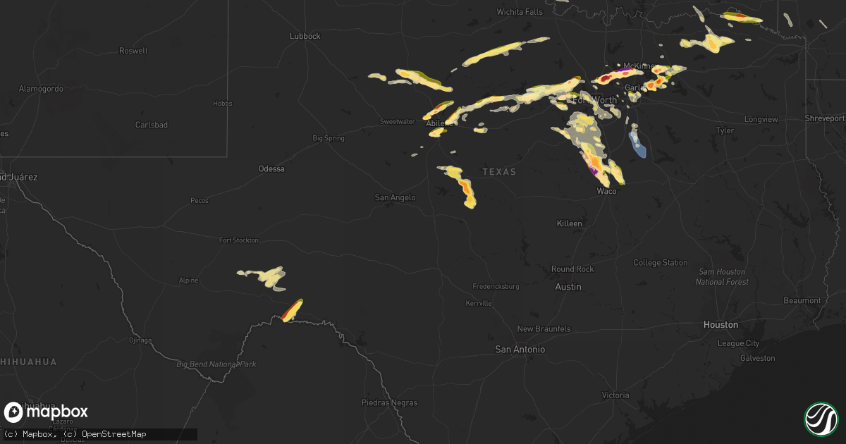
Hail Map in Texas on June 11, 2023
Get this storm
June 11 map
$229
one time, instant access
Download today. No call, no setup
Keep the $229
Bought the map and want the full workflow? Apply the entire $229 to a subscription within 7 days. None of it is wasted.
Every map, not just this one
This buys you this map. Subscription and you get every map we run, in the markets you choose from a few cities to whole states to nationwide. Plus real-time alerts the moment a storm fires.
Contact data
Name, contact info, occupancy, even credit band for addresses in the footprint. You go from where it hit to who to call.
Become the source they trust
Unlimited branding weather history reports on demand. You already have the documented answer ready for the property owner, and you are the one who showed up with it.
Property data and RoofTrace estimates
Pull up any address you have got, its value and the exact code rules for that jurisdiction, straight from One Click Code. Then RoofTrace estimates the squares, pitch, and roof value, priced the way you price.
Storm reports in Texas
Texas
| Date | Description |
|---|---|
| 06/11/20236:53 PM CDT | Report from the intersection of county road 416 and wimberly road. |
| 06/11/20236:45 PM CDT | A local report indicates 1.75 inch wind near 2 SW Stith |
| 06/11/20236:45 PM CDT | A picture of ping pong ball sized hail was posted on facebook. |
| 06/11/20236:45 PM CDT | A local report indicates 1.75 inch wind near 2 SW Stith |
| 06/11/20236:45 PM CDT | A picture of ping pong ball sized hail was posted on facebook. |
| 06/11/20236:38 PM CDT | Photo of half dollar and golf ball size hail from social media. |
| 06/11/20236:31 PM CDT | Quarter hail reported in weatherford... Tx. |
| 06/11/20236:01 PM CDT | A local report indicates 1.50 inch wind near 1 ESE Potosi |
| 06/11/20235:45 PM CDT | A local report indicates 1.75 inch wind near 5 NNE Buffalo Gap |
| 06/11/20235:45 PM CDT | A local report indicates 1.50 inch wind near Abilene |
| 06/11/20235:44 PM CDT | A local report indicates 1.25 inch wind near 6 E View |
| 06/11/20235:28 PM CDT | A local report indicates 1.00 inch wind near 2 W Potosi |
| 06/11/20235:39 AM CDT | A local report indicates 1.75 inch wind near Panhandle |
| 06/11/20234:59 AM CDT | A local report indicates 2.50 inch wind near Fritch |
| 06/11/20234:59 AM CDT | Corrects report of tennis ball sized hail in fritch at the same time. |
| 06/11/20234:55 AM CDT | Photo was submitted via social media. |
| 06/11/20234:45 AM CDT | A local report indicates 1.50 inch wind near 3 SE Fritch |
| 06/11/20234:32 AM CDT | Photo submitted via social media. Time estimated on radar. |
| 06/11/20234:30 AM CDT | Photo submitted via social media. |
| 06/11/20234:30 AM CDT | Photo submitted via social media. |
| 06/11/20234:30 AM CDT | Photo submitted via social media. |
| 06/11/20234:13 AM CDT | Report from mping: hen egg |
| 06/11/20234:06 AM CDT | Photo was submitted via social media. |
| 06/11/20233:16 AM CDT | Report from social media with picture. Time estimated based off radar. |
| 06/11/20233:15 AM CDT | Photo of the hailstones were submitted on social media. |
| 06/11/20233:14 AM CDT | Broken windows and house damage within the town of dalhart. |
| 06/11/20233:12 AM CDT | Corrects previous hail report from 1 se dalhart. Hail started at 3:12 am and lasted through 3:17 am. |
| 06/11/20233:10 AM CDT | A local report indicates 71 MPH wind near 3 SW Dalhart |
| 06/11/202312:41 AM CDT | Trained spotter called in ping pong |
| 06/11/202312:35 AM CDT | Jones co. Sheriff called stating that a deputy south of stanford reported a possible tornado on ground... Rain wrapped and heading toward avoca... Tx. |
| 06/11/202312:28 AM CDT | Trained spotter called in golf ball size hail. |
| 06/10/202311:42 PM CDT | Received a report of a tree that had fallen onto a house in whitney. No information on injuries. |
| 06/10/202311:39 PM CDT | Corrects previous hail report from 8 ssw whitney. Two inch hail reported on fm 56... Two miles south of laguna park. |
| 06/10/202311:39 PM CDT | Two inch hail reported on fm 56... Two miles south of laguna park. |
| 06/10/202311:27 PM CDT | Report from mping of ping pong ball size hail. |
| 06/10/202311:27 PM CDT | A local report indicates 60 MPH wind near 4 WNW Stratford |
| 06/10/202311:25 PM CDT | Trained storm spotter reported two inch hail in whitney. |
| 06/10/202311:17 PM CDT | Report from mping of ping pong ball size hail. |
| 06/10/202311:10 PM CDT | Some accumulating up to half inch deep on side of the highway. |
| 06/10/202311:01 PM CDT | Corrects previous tstm wnd dmg report from bogata. A power line was downed in bogata... Setting a tree on fire. |
| 06/10/202310:49 PM CDT | A local report indicates 1.00 inch wind near 23 NNE Ware |
| 06/10/202310:15 PM CDT | A local report indicates 2.00 inch wind near 2 NNE Turkey |
| 06/10/202310:01 PM CDT | A power line was downed in bogata... Setting a tree on fire. |
| 06/10/20239:57 PM CDT | A local report indicates 1.25 inch wind near 4 NNE Caprock Canyons S |
| 06/10/20239:57 PM CDT | . |
| 06/10/20239:55 PM CDT | Reports of large trees and power lines down near emhouse... Tx to corbet... Tx. |
| 06/10/20239:54 PM CDT | Reports of golf ball hail in springtown. |
| 06/10/20239:42 PM CDT | Trained spotter reported 1 in hail in greenville. |
| 06/10/20239:38 PM CDT | Quarter size hail reported near joshua. |
| 06/10/20239:37 PM CDT | Delayed report. Pictures were posted to social media of golfball size hail that fell along highway 195 just west of highway 37 in the albion community. |
| 06/10/20239:35 PM CDT | Report of half inch to ping pong ball size hail near cr915 and fm1902. |
| 06/10/20239:31 PM CDT | Ping pong to baseball sized hail. |
| 06/10/20239:10 PM CDT | Delayed report. Two inch hail was reported in farmersville. Time estimated via radar. |
| 06/10/20239:09 PM CDT | Quarter size hail reported in downtown famersville... Tx by trained spotter. |
| 06/10/20239:04 PM CDT | West texas mesonet at vigo park. |
| 06/10/20239:00 PM CDT | Delayed report. A hail stone measuring 3.5 inches was reported at the intersection of main street and teel parkway in frisco. Report received via social media. Time est |
| 06/10/20238:55 PM CDT | Delayed report. Oblong 2.5 inch hail was reported via mping. |
| 06/10/20238:54 PM CDT | Reports of quarter to half dollar hail in the colony... Tx. |
| 06/10/20238:54 PM CDT | Fd reports 2 inch hail in frisco. |
| 06/10/20238:53 PM CDT | Delayed report. Golf ball size hail was reported via social media off of legacy drive in frisco. |
| 06/10/20238:50 PM CDT | Delayed report. Three inch hail was reported in the colony. |
| 06/10/20238:46 PM CDT | Several reports of quarter to golf ball hail near hackberry. |
| 06/10/20238:45 PM CDT | Report of tennis ball to baseball size hail in the colony east of lewisville lake. |
| 06/10/20238:39 PM CDT | Trained spotter reported 3.5 in hail in bartonville |
| 06/10/20238:37 PM CDT | Delayed report. Report of ping pong ball size hail was received via mping. |
| 06/10/20238:30 PM CDT | Fire chief report. |
| 06/10/20238:29 PM CDT | A local report indicates 2.00 inch wind near 1 WSW Happy |
| 06/10/20238:29 PM CDT | West texas mesonet at happy 1e. |
| 06/10/20238:29 PM CDT | Report of 2.75 in to 3 inch hail in highland village |
| 06/10/20238:28 PM CDT | Report of tennis ball |
| 06/10/20238:28 PM CDT | Report of quarter |
| 06/10/20238:27 PM CDT | A local report indicates 1.25 inch wind near Happy |
| 06/10/20238:25 PM CDT | Report and picture relayed via social media. |
| 06/10/20238:25 PM CDT | Report and picture relayed via social media. |
| 06/10/20238:25 PM CDT | Photo was submitted via social media. |
| 06/10/20238:22 PM CDT | A local report indicates 2.75 inch wind near 1 WSW Happy |
| 06/10/20238:21 PM CDT | Report of up to golf ball |
| 06/10/20238:20 PM CDT | Photo shared via social media of 4.25 inch hail near the inn springtown. |
| 06/10/20238:20 PM CDT | Photo shared via social media of 4.25 inch hail near the intersection of cross timbers rd and shiloh rd in flower mound. |
| 06/10/20238:20 PM CDT | Delayed report. 2 inch hail reported in highland village. |
| 06/10/20238:20 PM CDT | Report via social media with damaged windshield. |
| 06/10/20238:15 PM CDT | A local report indicates 4.00 inch wind near Flower Mound |
| 06/10/20238:15 PM CDT | Trained spotter reports of quarter to tennis ball hail in flower mound. |
| 06/10/20238:13 PM CDT | Reports of hail up to golf ball size |
| 06/10/20238:05 PM CDT | Report of ping pong to golf ball hail in trophy club. |
| 06/10/20238:05 PM CDT | Report of half dollar |
| 06/10/20238:03 PM CDT | Delayed report. Half dollar size hail was reported via mping. |
| 06/10/20238:00 PM CDT | Quarter to golf ball size hail reported in trophy club near hwy 114 and 170. |
| 06/10/20238:00 PM CDT | Report of golf ball |
| 06/10/20238:00 PM CDT | Delayed report. Half dollar to golf ball size hail was reported in roanoke. |
| 06/10/20237:59 PM CDT | Report of hail up to ping pong balls nw of roanoke. |
| 06/10/20237:58 PM CDT | Report of half dollar |
| 06/10/20237:56 PM CDT | Report of half dollar |
| 06/10/20237:56 PM CDT | Trained spotter reports quarter sized hail in downtown godley. |
| 06/10/20237:56 PM CDT | Reports of quarter sized hail in dallas ne of university park. |
| 06/10/20237:50 PM CDT | Mesonet site reported 58 mph winds at 7:52 pm cdt. |
| 06/10/20237:50 PM CDT | Report of quarter |
| 06/10/20237:48 PM CDT | Report was via social media with hail up to ping pong ball size. |
| 06/10/20237:45 PM CDT | A local report indicates 1.00 inch wind near 2 SW Vega |
| 06/10/20237:44 PM CDT | Delayed report. 2 inch hail reported about 1 mile ne of downtown rockwall. |
| 06/10/20237:43 PM CDT | Photo on social media and reports of quarter to near baseball size hail in royse city. |
| 06/10/20237:42 PM CDT | Report of quarter size hail near westworth. Tersection of cross timbers rd and shiloh rd in flower mound. |
| 06/10/20237:42 PM CDT | Report of quarter |
| 06/10/20237:42 PM CDT | Corrects the time of the previous hail report from hawley. Ham radio operator received a report of 1 hail in hawley. |
| 06/10/20237:40 PM CDT | Delayed report. Ping pong ball size hail was reported in fate. |
| 06/10/20237:40 PM CDT | Delayed report. Tennis ball size hail was reported in roanoke via social media. |
| 06/10/20237:35 PM CDT | Report of 2.25 inch hail near fate... Tx. |
| 06/10/20237:35 PM CDT | Several reports of ping pong ball size hail up to hen egg+ |
| 06/10/20237:33 PM CDT | Delayed report. Quarter size hail was reported at the corner of highway 276 and faircrest drive in rockwall. |
| 06/10/20237:30 PM CDT | Report of several measured golf ball to ping pong ball size hail stones south of i-30 near the intersection of fm548 and rowdy dr. |
| 06/10/20237:30 PM CDT | Fort worth nas...tx |
| 06/10/20237:24 PM CDT | Report of quarters to golf ball hail in rockwall. |
| 06/10/20237:24 PM CDT | Report made via social media. |
| 06/10/20237:24 PM CDT | Report via social media with hail between half-dollar to ping pong ball size hail. |
| 06/10/20237:15 PM CDT | Report via social media with estimates of tennis to baseball sized hail. No picture to confirm. |
| 06/10/20237:13 PM CDT | A local report indicates 1.75 inch wind near Hawley |
| 06/10/20237:07 PM CDT | Report via social media... No picture to confirm. Tennis to baseball size hail fell around 8 miles southwest of adrian. |
| 06/10/20237:02 PM CDT | Photo of quarter sized hail n of aledo on social media. |
| 06/10/20237:00 PM CDT | Baseball hail broke vehicle windshield. |
All States Impacted by Hail Map on June 11, 2023
Cities Impacted by Hail Map on June 11, 2023
- Axtell, NE
- Minden, NE
- Chanute, KS
- Erie, KS
- Galesburg, KS
- Sandersville, GA
- Columbia, SC
- Elgin, SC
- Lugoff, SC
- Quinton, OK
- Red Oak, OK
- Kinta, OK
- Wilburton, OK
- Walsenburg, CO
- Hardaway, AL
- Tuskegee, AL
- Lebanon, TN
- Watertown, TN
- Brush Creek, TN
- Alexandria, TN
- Liberty, KY
- Elk Horn, KY
- Aguilar, CO
- Talihina, OK
- Wister, OK
- Charlotte, TN
- White Bluff, TN
- Ashland City, TN
- Albany, KY
- Baxter, TN
- Bloomington Springs, TN
- Gainesboro, TN
- Cookeville, TN
- Trinidad, CO
- Hustonville, KY
- Middleburg, KY
- Byrdstown, TN
- Monroe, TN
- Pall Mall, TN
- Monticello, KY
- Livingston, TN
- Rickman, TN
- Allred, TN
- Crawford, TN
- Alpine, TN
- Nancy, KY
- Somerset, KY
- Russell Springs, KY
- Ferguson, KY
- Windsor, KY
- Dunnville, KY
- Yosemite, KY
- Nashville, TN
- Madison, TN
- Old Hickory, TN
- Hendersonville, TN
- Jamestown, TN
- Wilder, TN
- Model, CO
- Littleton, CO
- Lone Tree, CO
- Sedalia, CO
- Grantville, GA
- Moreland, GA
- Luthersville, GA
- Castle Rock, CO
- Parker, CO
- Franktown, CO
- Allardt, TN
- Branson, CO
- Trinchera, CO
- Stuttgart, AR
- Hazen, AR
- De Valls Bluff, AR
- Roe, AR
- Sharpsburg, GA
- Newnan, GA
- Senoia, GA
- Clarendon, AR
- Altheimer, AR
- Wabbaseka, AR
- Elizabeth, CO
- Holly Grove, AR
- Crossville, TN
- Crab Orchard, TN
- Rockwood, TN
- Proctor, AR
- Helenwood, TN
- Huntsville, TN
- Wynne, AR
- Walls, MS
- Abilene, TX
- Buffalo Gap, TX
- Tuscola, TX
- Pioneer, TN
- Oneida, TN
- Horn Lake, MS
- Byhalia, MS
- Red Banks, MS
- Trumann, AR
- Marked Tree, AR
- Oakdale, TN
- Wartburg, TN
- Tyronza, AR
- Lepanto, AR
- Brinkley, AR
- Aubrey, AR
- Oliver Springs, TN
- Harriman, TN
- Newcomb, TN
- Morrilton, AR
- La Follette, TN
- Plumerville, AR
- Kim, CO
- Dryden, TX
- Southaven, MS
- Clyde, TX
- Joiner, AR
- Dyess, AR
- Albany, TX
- Greenbrier, AR
- Conway, AR
- Gouldbusk, TX
- Coleman, TX
- Santa Anna, TX
- Lake Cormorant, MS
- Weatherford, TX
- Nesbit, MS
- Tipp City, OH
- De Witt, AR
- Gillett, AR
- Kings Mountain, KY
- Waynesburg, KY
- Statesboro, GA
- Metter, GA
- Register, GA
- Springfield, TN
- White House, TN
- Cherry Valley, AR
- Hickory Ridge, AR
- Stanton, TN
- Hogansville, GA
- Lagrange, GA
- Carthage, TN
- Louviers, CO
- Flippin, AR
- Lake George, CO
- Lyons, GA
- Swainsboro, GA
- Midville, GA
- Crane, MO
- Marionville, MO
- Billings, MO
- Dixon Springs, TN
- Riddleton, TN
- Hartsville, TN
- Fort Stockton, TX
- Greensburg, KY
- Campbellsville, KY
- Pleasant Shade, TN
- Guyton, GA
- Rocky Ford, GA
- Millen, GA
- Sylvania, GA
- Crab Orchard, KY
- Newport, AR
- Bradford, AR
- Hestand, KY
- Tompkinsville, KY
- Sparta, TN
- Humphrey, AR
- Marion, AR
- Ovalo, TX
- Jamestown, KY
- Garnett, SC
- Pineland, SC
- Moss, TN
- Whitleyville, TN
- Celina, TN
- Gay, GA
- Callahan, FL
- Beedeville, AR
- McCrory, AR
- Castalian Springs, TN
- Bethpage, TN
- Memphis, TN
- Olive Branch, MS
- Bloomingdale, GA
- Mount Juliet, TN
- Gallatin, TN
- Brigham City, UT
- Englewood, CO
- Dickson, TN
- Robbins, TN
- Headland, AL
- Brodhead, KY
- Hardyville, KY
- Knifley, KY
- Columbia, KY
- Dardanelle, AR
- Woodbury, TN
- Monterey, TN
- Milton, TN
- Lascassas, TN
- Allons, TN
- Valera, TX
- Hilham, TN
- Red Boiling Springs, TN
- Lafayette, TN
- Burkesville, KY
- Heth, AR
- Midway, GA
- Hilliard, FL
- Edmonton, KY
- Portland, TN
- Spring City, TN
- Mccurtain, OK
- Whitesboro, OK
- Notasulga, AL
- Auburn, AL
- Hermitage, TN
- Pegram, TN
- Norton, TX
- Mount Vernon, KY
- Cobbtown, GA
- Buffalo Valley, TN
- Ulm, AR
- Carlisle, AR
- Crawfordsville, AR
- Estill, SC
- Tillman, SC
- Parkin, AR
- Hickman, TN
- Gordonsville, TN
- Hobe Sound, FL
- Mason, TN
- Grenville, NM
- Folsom, NM
- Gould, AR
- Sunbright, TN
- Watson, AR
- Tichnor, AR
- Evensville, TN
- Hernando, MS
- Lenoir City, TN
- Knoxville, TN
- Farragut, TN
- Rochelle, TX
- Clinton, TN
- Briceville, TN
- Michie, TN
- Counce, TN
- Coldwater, MS
- Boise, ID
- Courtland, MS
- Batesville, MS
- Fort Worth, TX
- Azle, TX
- Oxford, MS
- Rohwer, AR
- Benoit, MS
- Merkel, TX
- Hawley, TX
- Almyra, AR
- Hereford, TX
- Adrian, TX
- Taylor, MS
- Potts Camp, MS
- Myrtle, MS
- Water Valley, MS
- Marianna, AR
- Rockwall, TX
- Royse City, TX
- Tunica, MS
- New Albany, MS
- Pontotoc, MS
- Roanoke, TX
- Ecru, MS
- Blue Springs, MS
- Southlake, TX
- Flower Mound, TX
- Anson, TX
- Lueders, TX
- Boise City, OK
- Kenton, OK
- Thaxton, MS
- Randolph, MS
- Moran, TX
- Breckenridge, TX
- Ethel, AR
- Snow Lake, AR
- Gunnison, MS
- Belden, MS
- Cisco, TX
- Lohn, TX
- Naval Air Station Jrb, TX
- Tupelo, MS
- Argyle, TX
- Lewisville, TX
- Toccoa, GA
- Eastanollee, GA
- Cranks, KY
- Pennington Gap, VA
- Rosedale, MS
- Merigold, MS
- Mound Bayou, MS
- Vega, TX
- Wildorado, TX
- Dallas, TX
- Canyon, TX
- Happy, TX
- Banner, MS
- Bruce, MS
- Granbury, TX
- Godley, TX
- Cleburne, TX
- Capulin, NM
- Des Moines, NM
- Raton, NM
- Strawn, TX
- Graford, TX
- Palo Pinto, TX
- Lake Dallas, TX
- Beulah, MS
- The Colony, TX
- Carrollton, TX
- Plano, TX
- Jasper, GA
- Marble Hill, GA
- Dawsonville, GA
- Frisco, TX
- Grandview, TX
- Rio Vista, TX
- Mineral Wells, TX
- Allen, TX
- Covington, TX
- Mckinney, TX
- Ennis, TX
- Waxahachie, TX
- Keyes, OK
- Amarillo, TX
- Tulia, TX
- Perrin, TX
- Joshua, TX
- Crowley, TX
- Silverton, TX
- Barry, TX
- Italy, TX
- Blooming Grove, TX
- Corsicana, TX
- Poolville, TX
- Clayton, NM
- Springtown, TX
- Agate, CO
- Limon, CO
- Matheson, CO
- Burleson, TX
- Purdon, TX
- Texhoma, OK
- Goodwell, OK
- Cleveland, MS
- Boyle, MS
- Shaw, MS
- Indianola, MS
- Clarendon, TX
- Quitaque, TX
- Boyd, TX
- Paradise, TX
- Tolar, TX
- Rhome, TX
- Glen Rose, TX
- Moorhead, MS
- Greenville, TX
- Honey Grove, TX
- Ladonia, TX
- Roxton, TX
- Caddo Mills, TX
- Pecan Gap, TX
- Paris, TX
- Pattonville, TX
- Rainbow, TX
- Aquilla, TX
- Abbott, TX
- West, TX
- Deport, TX
- Lake Creek, TX
- Penelope, TX
- Mount Calm, TX
- Sulphur Bluff, TX
- Cooper, TX
- Childress, TX
- Turkey, TX
- Felt, OK
- Clarksville, TX
- Idabel, OK
- Haworth, OK
- Blum, TX
- Kopperl, TX
- Axtell, TX
- Hubbard, TX
- Bogata, TX
- Miami, NM
- Springer, NM
- Greenville, MS
- Leland, MS
- Mart, TX
- Dalhart, TX
- Whitney, TX
- Tell, TX
- Stratford, TX
- Morgan, TX
- Clifton, TX
- Valley Mills, TX
- Aspermont, TX
- Hollandale, MS
- Waco, TX
- China Spring, TX
- Anguilla, MS
- Belzoni, MS
- Louise, MS
- Hampton, AR
- Sarah, MS
- Crenshaw, MS
- Kiowa, CO
- Winfield, TN
- Sparkman, AR
- Camden, AR
- McRae Helena, GA
- Glenwood, GA
- Sledge, MS
- Dacula, GA
- Maxwell, NM
- Covington, TN
- Riverside, OR
- Springfield, GA
- Haleyville, AL
- Phil Campbell, AL
- Waynesboro, TN
- Clifton, TN
- Bath Springs, TN
- Bronston, KY
- Colt, AR
- Howard, CO
- Claxton, GA
- Millsap, TX
- Senatobia, MS
- Como, MS
- Sardis, MS
- Lawrenceville, GA
- Loxahatchee, FL
- Blossom, TX
- Detroit, TX
- Kingston, TN
- Pritchett, CO
- Mesquite, TX
- Princeton, TX
- Milliken, CO
- Ranger, TX
- Rienzi, MS
- Gordon, TX
- Baird, TX
- Caddo, TX
- Jacksonville, FL
- Richmond Hill, GA
- Guffey, CO
- Kingston Springs, TN
- Fairview, TN
- Augusta, AR
- Gurdon, AR
- Rowlett, TX
- Lula, GA
- Alto, GA
- Cornelia, GA
- Coppell, TX
- Washington, AR
- Columbus, AR
- Fulton, AR
- Wylie, TX
- Quinlan, TX
- Nevada, TX
- Rosie, AR
- Oil Trough, AR
- Thida, AR
- Magness, AR
- Fernandina Beach, FL
- Newville, AL
- Abbeville, AL
- Columbia, AL
- Ten Mile, TN
- Dayton, TN
- Ball Ground, GA
- Moro, AR
- Palestine, AR
- Talpa, TX
- Decaturville, TN
- Bairoil, WY
- Simla, CO
- Philadelphia, TN
- Loudon, TN
- Houlka, MS
- Houston, MS
- Fleming, GA
- Cotopaxi, CO
- Dundee, MS
- Holly Springs, MS
- Grapevine, TX
- Russellville, AL
- Helena, AR
- Marvell, AR
- Lexa, AR
- Poplar Grove, AR
- Cordova, TN
- Ramah, CO
- Lawrenceburg, TN
- Summertown, TN
- Ethridge, TN
- Belmont, MS
- Foreman, AR
- Ashdown, AR
- Palmer, TX
- Townville, SC
- Norcross, GA
- Lilburn, GA
- Dahlonega, GA
- Waterford, MS
- Garland, TX
- Baldwin, GA
- Tishomingo, MS
- Cherokee, AL
- Greenville, GA
- Keller, TX
- Cumming, GA
- Jellico, TN
- Duff, TN
- Drummonds, TN
- Rocky Top, TN
- Rockwood, TX
- Paris, ID
- Little Elm, TX
- Chidester, AR
- Twin Falls, ID
- Delta, UT
- Bard, NM
- Munford, TN
- Atoka, TN
- Bagwell, TX
- Red Oak, TX
- Grand Prairie, TX
- Irving, TX
- Mountain View, AR
- Dennis, MS
- Red Bay, AL
- Hickory Flat, MS
- Blue Mountain, MS
- Brighton, TN
- Lancing, TN
- Glennville, GA
- Aurora, CO
- Tarrytown, GA
- Vidalia, GA
- Dumas, AR
- Murrayville, GA
- Cleveland, GA
- Saltillo, MS
- Mantachie, MS
- Mooreville, MS
- Osceola, AR
- Etowah, AR
- Etta, MS
- Abbeville, MS
- Paris, MS
- Rising Star, TX
- Peachtree City, GA
- Sumner, TX
- Arlington, TX
- Mansfield, TX
- Cedar Hill, TX
- Midlothian, TX
- Spruce Pine, AL
- Iuka, MS
- Bearden, AR
- Alamo, GA
- Fairmount, GA
- Rydal, GA
- Cascade, ID
- West Helena, AR
- Oak Ridge, TN
- Melbourne, AR
- Batesville, AR
- Fifty Six, AR
- Pleasant Grove, AR
- Clarkesville, GA
- Demorest, GA
- Tillar, AR
- England, AR
- Lonoke, AR
- Franklin, TN
- Farmersville, TX
- Westpoint, TN
- Niota, TN
- Decatur, TN
- Bluff City, AR
- Prescott, AR
- Powell, TN
- Heiskell, TN
- Earle, AR
- Kingsland, AR
- Sunnyvale, TX
- Bloomington, ID
- Guys, TN
- Winthrop, AR
- Grimsley, TN
- Guntown, MS
- Weston, CO
- Savannah, GA
- Pooler, GA
- Waterloo, AL
- Hinesville, GA
- Mount Airy, GA
- Mount Vernon, GA
- Soperton, GA
- Brickeys, AR
- Robinsonville, MS
- Booneville, MS
- Corinth, MS
- Okolona, MS
- Williamsburg, KY
- Cresson, TX
- Wingate, TX
- Winters, TX
- Bunnell, FL
- Nettleton, MS
- Canon City, CO
- Elmwood, TN
- Auburntown, TN
- Screven, GA
- Sachse, TX
- Lavon, TX
- Grandview, TN
- Boswell, OK
- Vardaman, MS
- Pittsboro, MS
- Lancaster, TX
- Tate, GA
- Marks, MS
- Newark, TX
- Germantown, TN
- Eads, TN
- Collierville, TN
- Bryceville, FL
- Andersonville, TN
- Thornton, AR
- Arthur City, TX
- Plantersville, MS
- Fulton, MS
- Shannon, MS
- Smithville, MS
- Amory, MS
- Corinne, UT
- Frenchmans Bayou, AR
- Bassett, AR
- Williamson, GA
- Brooks, GA
- Haslet, TX
- Widener, AR
- Hughes, AR
- Aledo, TX
- Dowelltown, TN
- Liberty, TN
- Ramer, TN
- Ludowici, GA
- Hugo, OK
- Venus, TX
- Kennedale, TX
- Alvarado, TX
- Old Glory, TX
- Elm Mott, TX
- Gruver, TX
- Texhoma, TX
- Rule, TX
- Stamford, TX
- Arkansas City, AR
- Gladstone, NM
- Inverness, MS
- Isola, MS
- Avoca, TX
- Demopolis, AL
- Sedan, NM
- Throckmorton, TX
- Texline, TX
- Mosquero, NM
- Nara Visa, NM
- Amistad, NM
- Hartley, TX
- Channing, TX
- Logan, NM
- Newcastle, TX
- Olney, TX
- Holliday, TX
- Ocate, NM
- Wagon Mound, NM
- Windthorst, TX
- Grady, AR
- Tellico Plains, TN
- Johnstown, CO
- Snellville, GA
- Grayson, GA
- Juntura, OR
- West Point, MS
- Prairie, MS
- Westminster, SC
- Union Point, GA
- Tuttle, OK
- Blanchard, OK
- Newcastle, OK
- Starkville, MS
- Cedarbluff, MS
- Columbus, MS
- Campbell, TX
- Snyder, TX
- Keiser, AR
- Ben Franklin, TX
- Nemo, TX
- Gardendale, AL
- Pope, MS
- Loretto, TN
- Deatsville, AL
- Marbury, AL
- McGehee, AR
- Martin, GA
- Oxford, AL
- Munford, AL
- Rincon, GA
- Hillsboro, TX
- Double Springs, AL
- Keene, TX
- Twain, CA
- Quincy, CA
- Guion, AR
- Calico Rock, AR
- Mount Pleasant, AR
- Eutaw, AL
- Boligee, AL
- De Kalb, MS
- Scooba, MS
- Pinson, AL
- Birmingham, AL
- Morris, AL
- Warrior, AL
- Mount Olive, AL
- Itasca, TX
- Mora, NM
- Cimarron, NM
- Norfork, AR
- Fair Play, SC
- Macon, MS
- Canton, GA
- Rotan, TX
- York, AL
- Cuba, AL
- Central, SC
- Anderson, SC
- Pendleton, SC
- Liberty, SC
- Clemson, SC
- Faunsdale, AL
- Woodland, MS
- Verbena, AL
- Jayton, TX
- Hugo, CO
- Houston, AL
- Pine Apple, AL
- Porterville, MS
- Casscoe, AR
- Aliceville, AL
- New Market, AL
- Carnesville, GA
- Tuskegee Institute, AL
- Louisville, GA
- Seneca, SC
- Lillian, TX
- Wayside, TX
- Trenton, TX
- Whitewright, TX
- Norman, OK
- Washington, OK
- Noble, OK
- Lexington, OK
- Mustang, OK
- Oklahoma City, OK
- Roy, NM
- Dumas, TX
- Sunray, TX
- Stinnett, TX
- Panhandle, TX
- Fritch, TX
- Masterson, TX
- Skellytown, TX
- Borger, TX
- Pampa, TX
- White Deer, TX
- Groom, TX
- Sayre, OK
- Carter, OK
- Elk City, OK
- Dill City, OK
- Canute, OK
- Hobart, OK
- Gotebo, OK
- Roosevelt, OK
- Mountain View, OK
- Carnegie, OK
- Hammon, OK
- Butler, OK
- Foss, OK
- Paoli, OK
- Pauls Valley, OK
- Stratford, OK
- Apache, OK
- Sentinel, OK
- Cordell, OK
- Clinton, OK
- Mclean, TX
- Lawton, OK
- Elgin, OK
- Shamrock, TX
- Fletcher, OK
- Rush Springs, OK
- Marlow, OK
- Erick, OK
- Temple, OK
- Walters, OK
- Comanche, OK
- Waurika, OK
- Ringling, OK
- Ryan, OK
- Verona, MS
- Science Hill, KY
- Norris, TN
- Maynardville, TN
- Cheyenne, OK
- Rainsville, NM
- Adrian, GA
- Kite, GA
- Wrightsville, GA
- Willow, OK
- Fitzhugh, OK
- Ada, OK
- Henrietta, TX
- Bellevue, TX
- Castleberry, AL
- Brewton, AL
- Fort Sill, OK
- Uniontown, AL
- Thomaston, AL
- Safford, AL
- Catherine, AL
- Purcell, OK
- Lone Wolf, OK
- Granite, OK
- Cyril, OK
- Newbern, AL
- Cement, OK
- Lindsay, OK
- Meigs, GA
- Sale City, GA
- Hartsfield, GA
- Camden, AL
- Fort Cobb, OK
- Pennington, AL
- Sweet Water, AL
- Linden, AL
- Bellamy, AL
- Livingston, AL
- Reydon, OK
- Annona, TX
- Arlington, AL
- Wilson, OK
- Hastings, OK
- Silver City, MS
- Rocky, OK
- Coy, AL
- Pine Hill, AL
- Hurtsboro, AL
- Hatchechubbee, AL
- Tallassee, AL
- Haskell, TX
- Celeste, TX
- Leonard, TX
- Weatherford, OK
- Arapaho, OK
- Denton, TX
- Shorter, AL
- Georgiana, AL
- Evergreen, AL
- McKenzie, AL
- Magnolia, AL
- Alberta, AL
- Byars, OK
- Wheeler, TX
- Minter, AL
- Gallion, AL
- Orrville, AL
- Pittsview, AL
- Sweetwater, OK
- Auburn, GA
- Anadarko, OK
- Miami, TX
- Canadian, TX
- Range, AL
- Lenox, AL
- Repton, AL
- Briscoe, TX
- Monroeville, AL
- Corn, OK
- Lower Peach Tree, AL
- Texola, OK
- Christiansburg, OH
- Saint Paris, OH
- York, PA


