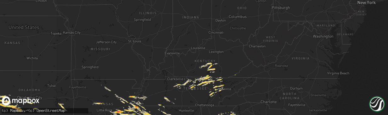
Hail Map in Kentucky on June 11, 2023
The weather event in Kentucky on June 11, 2023 includes Hail, Wind, and Tornado maps. 23 states and 920 cities were impacted and suffered possible damage. The total estimated number of properties impacted is 15,958.
Want more than just the map?
Turn this storm into a full workflow.
- Owner + property data so you know who to knock
- OnDemand branded weather history reports to win the "did we even have hail?" argument
- RoofTrace estimate so reps stop guessing numbers at the door
Bought this map? Upgrade within 7 days and we'll credit the $230. (10-15 min setup call)
Hail
Wind
Tornado
15,958
Estimated number of impacted properties by a 1.00" hail or larger5,616
Estimated number of impacted properties by a 1.75" hail or larger2,890
Estimated number of impacted properties by a 2.50" hail or largerStorm reports in Kentucky
Kentucky
| Date | Description |
|---|---|
| 06/11/20236:46 PM CDT | A tree was blown down along ky 92 in this vicinity. |
| 06/11/20236:43 PM CDT | A tree was blown down onto powerlines near 283 hubbard hollow road. |
| 06/11/20236:22 PM CDT | A tree was down near the intersection of ky 26 and new zion road and another tree was down nearby on new zion road. |
| 06/11/20236:13 PM CDT | A tree was blown down near the intersection of ky 895 and ky 204. |
| 06/11/20236:00 PM CDT | A tree was reported to have been blown down onto sandhill road. |
| 06/11/20235:29 PM CDT | Several trees and powerlines down over roadways in franklin. |
| 06/11/20235:10 PM CDT | A tree was reported to have been blown down onto ky 2392. |
| 06/11/20234:43 PM CDT | A tree was blown down onto ky3630 near dollar general. |
| 06/11/20234:19 PM CDT | A tree was reported to be leaning on power lines at 234 lanetown road |
| 06/11/20234:15 PM CDT | Trees were reported to have been blown down in and near livingston. |
| 06/11/20234:10 PM CDT | Trees were down in and near brodhead. The event time is radar estimated from occurrence of strongest velocity in the area. |
| 06/11/20234:05 PM CDT | A tree was reported to have been blown down onto a residence. |
| 06/11/20234:04 PM CDT | A power line was reported down across elliott drive in somerset... Near loveless lane. |
| 06/11/20234:02 PM CDT | Several trees were blown down in and near mount vernon including two trees down onto homes in mount vernon and one also down onto a vehicle. |
| 06/11/20233:59 PM CDT | A tree was reported to have been blown onto powerlines along mo hollow road. |
| 06/11/20233:58 PM CDT | A tree was reported to have been blown down onto powerlines along ky 167. |
| 06/11/20233:57 PM CDT | Trees were blown down and blocking the roadway at 2135 oak hill road |
| 06/11/20233:55 PM CDT | A local report indicates 1.25 inch wind near 1 N Somerset |
| 06/11/20233:54 PM CDT | A tree was reported down on house along paterson branch road. |
| 06/11/20233:53 PM CDT | A tree was reported down and across the road on hwy-1665... Near the intersection with burnetta road near the nancy community. |
| 06/11/20233:51 PM CDT | Social media video shared to local media with hail to around golf ball size falling. The event time is radar estimated. |
| 06/11/20233:51 PM CDT | Corrects previous tstm wnd dmg report from 2 w somerset pulaski county. Trees were blown down and blocking the roadway at 2135 oak hill road |
| 06/11/20233:51 PM CDT | Large branches were reported in the roadway on grand central blvd near the intersection with grand circle southwest of somerset. |
| 06/11/20233:51 PM CDT | A power line was down in the yard of a residence at 1712 patterson branch road southwest of somerset. The pole was reported to have possibly been broken. |
| 06/11/20233:50 PM CDT | A tree was rep tn 3641 8488 photo received via facebook of snapped power pole and downed trees. |
| 06/11/20233:50 PM CDT | A tree was reported to have been blown down and blocking the roadway at 3010 simpson drive southeast of somerset. |
| 06/11/20233:49 PM CDT | Social media picture shared from near the lees ford marina with hail to about golf ball size. The event time is radar estimated. |
| 06/11/20233:49 PM CDT | A local report indicates 1.00 inch wind near Somerset |
| 06/11/20233:49 PM CDT | Public report via social media. The event time is radar estimated. |
| 06/11/20233:48 PM CDT | Report from mping: ping pong ball |
| 06/11/20233:44 PM CDT | Report from mping: quarter |
| 06/11/20233:43 PM CDT | Multiple social media reports from the nancy area of hail to at least tennis ball size as this was the largest size shared in an image. Roof and siding damage to a few |
| 06/11/20233:43 PM CDT | What appears to be cable lines are laying across the road at 2341 slate branch road northwest of burnside. Time estimated by radar. |
| 06/11/20233:43 PM CDT | Trees were reported down for about a mile along highway 1664 at pierce road just west of nancy. Many of the trees were partially rotten or small... And preliminary asse |
| 06/11/20233:42 PM CDT | Several trees down over roadways in albany. |
| 06/11/20233:42 PM CDT | Quarter |
| 06/11/20233:40 PM CDT | A power line was reported down from winds at 345 pierce road near the community of nancy. |
| 06/11/20233:40 PM CDT | Corrects previous tstm wnd dmg report from nancy. A tree was reported to be leaning on power lines at 234 lanetown road |
| 06/11/20233:38 PM CDT | Trees were blocking the entire roadway on hwy-196... Just past the fire department near the community of nancy. |
| 06/11/20233:35 PM CDT | Trees were reported down along the cumberland parkway at the 78 mm |
| 06/11/20233:35 PM CDT | Corrects previous tstm wnd dmg report from 1 ene faubush. A tree was reported down and across the road on hwy-1665... Near the intersection with burnetta road near the |
| 06/11/20233:35 PM CDT | Corrects previous tstm wnd dmg report from 1 e faubush. Trees were reported down for about a mile along highway 1664 at pierce road just west of nancy. Many of the tree |
| 06/11/20233:35 PM CDT | A tree was downed and completely blocking hudson road |
| 06/11/20233:34 PM CDT | Corrects previous tstm wnd dmg report from 1 n faubush. A tree was reported blown down onto a garage at 2447 faubush road near the community of nancy. Time estimated fr |
| 06/11/20233:30 PM CDT | Trees were reported blown down across the road... Resulting in downed powerlines at the 2100 block of faubush road near the community of faubush. |
| 06/11/20233:30 PM CDT | A tree was reported blown down onto a garage at 2447 faubush road near the community of nancy. |
| 06/11/20233:30 PM CDT | Golf ball |
| 06/11/20233:22 PM CDT | Golf ball |
| 06/11/20233:20 PM CDT | Several trees down on roadways and roof blown off out building on south fork creek rd. |
| 06/11/20233:08 PM CDT | Trees down over ky-198. |
| 06/11/20233:05 PM CDT | Quarter |
| 06/11/20232:55 PM CDT | Trees down over north ky-501. |
| 06/11/20232:55 PM CDT | Multiple trees down at green river lake state park. One tree fell on camper. |
| 06/11/20232:55 PM CDT | Update to previous tstm wnd dmg report from 4 sw elk horn. Multiple trees down at green river lake state park. Multiple campers have sustained minor to severe damage fr |
| 06/10/20238:47 PM CDT | Corrects previous tstm wnd dmg report from 2 se wheeler. A tree was blown down along ky 92 in this vicinity. |
| 06/10/20237:56 PM CDT | Dispatcher at the harlan county 24-warning point received a report of a tree down across ky-522 blocking both lanes. |
| 06/10/20237:39 PM CDT | A tree was reported to have been blown down on ky 987. The even time is radar estimated. |
All States Impacted by Hail Map on June 11, 2023
Cities Impacted by Hail Map on June 11, 2023
- Axtell, NE
- Minden, NE
- Chanute, KS
- Erie, KS
- Galesburg, KS
- Sandersville, GA
- Columbia, SC
- Elgin, SC
- Lugoff, SC
- Quinton, OK
- Red Oak, OK
- Kinta, OK
- Wilburton, OK
- Walsenburg, CO
- Hardaway, AL
- Tuskegee, AL
- Lebanon, TN
- Watertown, TN
- Brush Creek, TN
- Alexandria, TN
- Liberty, KY
- Elk Horn, KY
- Aguilar, CO
- Talihina, OK
- Wister, OK
- Charlotte, TN
- White Bluff, TN
- Ashland City, TN
- Albany, KY
- Baxter, TN
- Bloomington Springs, TN
- Gainesboro, TN
- Cookeville, TN
- Trinidad, CO
- Hustonville, KY
- Middleburg, KY
- Byrdstown, TN
- Monroe, TN
- Pall Mall, TN
- Monticello, KY
- Livingston, TN
- Rickman, TN
- Allred, TN
- Crawford, TN
- Alpine, TN
- Nancy, KY
- Somerset, KY
- Russell Springs, KY
- Ferguson, KY
- Windsor, KY
- Dunnville, KY
- Yosemite, KY
- Nashville, TN
- Madison, TN
- Old Hickory, TN
- Hendersonville, TN
- Jamestown, TN
- Wilder, TN
- Model, CO
- Littleton, CO
- Lone Tree, CO
- Sedalia, CO
- Grantville, GA
- Moreland, GA
- Luthersville, GA
- Castle Rock, CO
- Parker, CO
- Franktown, CO
- Allardt, TN
- Branson, CO
- Trinchera, CO
- Stuttgart, AR
- Hazen, AR
- De Valls Bluff, AR
- Roe, AR
- Sharpsburg, GA
- Newnan, GA
- Senoia, GA
- Clarendon, AR
- Altheimer, AR
- Wabbaseka, AR
- Elizabeth, CO
- Holly Grove, AR
- Crossville, TN
- Crab Orchard, TN
- Rockwood, TN
- Proctor, AR
- Helenwood, TN
- Huntsville, TN
- Wynne, AR
- Walls, MS
- Abilene, TX
- Buffalo Gap, TX
- Tuscola, TX
- Pioneer, TN
- Oneida, TN
- Horn Lake, MS
- Byhalia, MS
- Red Banks, MS
- Trumann, AR
- Marked Tree, AR
- Oakdale, TN
- Wartburg, TN
- Tyronza, AR
- Lepanto, AR
- Brinkley, AR
- Aubrey, AR
- Oliver Springs, TN
- Harriman, TN
- Newcomb, TN
- Morrilton, AR
- La Follette, TN
- Plumerville, AR
- Kim, CO
- Dryden, TX
- Southaven, MS
- Clyde, TX
- Joiner, AR
- Dyess, AR
- Albany, TX
- Greenbrier, AR
- Conway, AR
- Gouldbusk, TX
- Coleman, TX
- Santa Anna, TX
- Lake Cormorant, MS
- Weatherford, TX
- Nesbit, MS
- Tipp City, OH
- De Witt, AR
- Gillett, AR
- Kings Mountain, KY
- Waynesburg, KY
- Statesboro, GA
- Metter, GA
- Register, GA
- Springfield, TN
- White House, TN
- Cherry Valley, AR
- Hickory Ridge, AR
- Stanton, TN
- Hogansville, GA
- Lagrange, GA
- Carthage, TN
- Louviers, CO
- Flippin, AR
- Lake George, CO
- Lyons, GA
- Swainsboro, GA
- Midville, GA
- Crane, MO
- Marionville, MO
- Billings, MO
- Dixon Springs, TN
- Riddleton, TN
- Hartsville, TN
- Fort Stockton, TX
- Greensburg, KY
- Campbellsville, KY
- Pleasant Shade, TN
- Guyton, GA
- Rocky Ford, GA
- Millen, GA
- Sylvania, GA
- Crab Orchard, KY
- Newport, AR
- Bradford, AR
- Hestand, KY
- Tompkinsville, KY
- Sparta, TN
- Humphrey, AR
- Marion, AR
- Ovalo, TX
- Jamestown, KY
- Garnett, SC
- Pineland, SC
- Moss, TN
- Whitleyville, TN
- Celina, TN
- Gay, GA
- Callahan, FL
- Beedeville, AR
- McCrory, AR
- Castalian Springs, TN
- Bethpage, TN
- Memphis, TN
- Olive Branch, MS
- Bloomingdale, GA
- Mount Juliet, TN
- Gallatin, TN
- Brigham City, UT
- Englewood, CO
- Dickson, TN
- Robbins, TN
- Headland, AL
- Brodhead, KY
- Hardyville, KY
- Knifley, KY
- Columbia, KY
- Dardanelle, AR
- Woodbury, TN
- Monterey, TN
- Milton, TN
- Lascassas, TN
- Allons, TN
- Valera, TX
- Hilham, TN
- Red Boiling Springs, TN
- Lafayette, TN
- Burkesville, KY
- Heth, AR
- Midway, GA
- Hilliard, FL
- Edmonton, KY
- Portland, TN
- Spring City, TN
- Mccurtain, OK
- Whitesboro, OK
- Notasulga, AL
- Auburn, AL
- Hermitage, TN
- Pegram, TN
- Norton, TX
- Mount Vernon, KY
- Cobbtown, GA
- Buffalo Valley, TN
- Ulm, AR
- Carlisle, AR
- Crawfordsville, AR
- Estill, SC
- Tillman, SC
- Parkin, AR
- Hickman, TN
- Gordonsville, TN
- Hobe Sound, FL
- Mason, TN
- Grenville, NM
- Folsom, NM
- Gould, AR
- Sunbright, TN
- Watson, AR
- Tichnor, AR
- Evensville, TN
- Hernando, MS
- Lenoir City, TN
- Knoxville, TN
- Farragut, TN
- Rochelle, TX
- Clinton, TN
- Briceville, TN
- Michie, TN
- Counce, TN
- Coldwater, MS
- Boise, ID
- Courtland, MS
- Batesville, MS
- Fort Worth, TX
- Azle, TX
- Oxford, MS
- Rohwer, AR
- Benoit, MS
- Merkel, TX
- Hawley, TX
- Almyra, AR
- Hereford, TX
- Adrian, TX
- Taylor, MS
- Potts Camp, MS
- Myrtle, MS
- Water Valley, MS
- Marianna, AR
- Rockwall, TX
- Royse City, TX
- Tunica, MS
- New Albany, MS
- Pontotoc, MS
- Roanoke, TX
- Ecru, MS
- Blue Springs, MS
- Southlake, TX
- Flower Mound, TX
- Anson, TX
- Lueders, TX
- Boise City, OK
- Kenton, OK
- Thaxton, MS
- Randolph, MS
- Moran, TX
- Breckenridge, TX
- Ethel, AR
- Snow Lake, AR
- Gunnison, MS
- Belden, MS
- Cisco, TX
- Lohn, TX
- Naval Air Station Jrb, TX
- Tupelo, MS
- Argyle, TX
- Lewisville, TX
- Toccoa, GA
- Eastanollee, GA
- Cranks, KY
- Pennington Gap, VA
- Rosedale, MS
- Merigold, MS
- Mound Bayou, MS
- Vega, TX
- Wildorado, TX
- Dallas, TX
- Canyon, TX
- Happy, TX
- Banner, MS
- Bruce, MS
- Granbury, TX
- Godley, TX
- Cleburne, TX
- Capulin, NM
- Des Moines, NM
- Raton, NM
- Strawn, TX
- Graford, TX
- Palo Pinto, TX
- Lake Dallas, TX
- Beulah, MS
- The Colony, TX
- Carrollton, TX
- Plano, TX
- Jasper, GA
- Marble Hill, GA
- Dawsonville, GA
- Frisco, TX
- Grandview, TX
- Rio Vista, TX
- Mineral Wells, TX
- Allen, TX
- Covington, TX
- Mckinney, TX
- Ennis, TX
- Waxahachie, TX
- Keyes, OK
- Amarillo, TX
- Tulia, TX
- Perrin, TX
- Joshua, TX
- Crowley, TX
- Silverton, TX
- Barry, TX
- Italy, TX
- Blooming Grove, TX
- Corsicana, TX
- Poolville, TX
- Clayton, NM
- Springtown, TX
- Agate, CO
- Limon, CO
- Matheson, CO
- Burleson, TX
- Purdon, TX
- Texhoma, OK
- Goodwell, OK
- Cleveland, MS
- Boyle, MS
- Shaw, MS
- Indianola, MS
- Clarendon, TX
- Quitaque, TX
- Boyd, TX
- Paradise, TX
- Tolar, TX
- Rhome, TX
- Glen Rose, TX
- Moorhead, MS
- Greenville, TX
- Honey Grove, TX
- Ladonia, TX
- Roxton, TX
- Caddo Mills, TX
- Pecan Gap, TX
- Paris, TX
- Pattonville, TX
- Rainbow, TX
- Aquilla, TX
- Abbott, TX
- West, TX
- Deport, TX
- Lake Creek, TX
- Penelope, TX
- Mount Calm, TX
- Sulphur Bluff, TX
- Cooper, TX
- Childress, TX
- Turkey, TX
- Felt, OK
- Clarksville, TX
- Idabel, OK
- Haworth, OK
- Blum, TX
- Kopperl, TX
- Axtell, TX
- Hubbard, TX
- Bogata, TX
- Miami, NM
- Springer, NM
- Greenville, MS
- Leland, MS
- Mart, TX
- Dalhart, TX
- Whitney, TX
- Tell, TX
- Stratford, TX
- Morgan, TX
- Clifton, TX
- Valley Mills, TX
- Aspermont, TX
- Hollandale, MS
- Waco, TX
- China Spring, TX
- Anguilla, MS
- Belzoni, MS
- Louise, MS
- Hampton, AR
- Sarah, MS
- Crenshaw, MS
- Kiowa, CO
- Winfield, TN
- Sparkman, AR
- Camden, AR
- McRae Helena, GA
- Glenwood, GA
- Sledge, MS
- Dacula, GA
- Maxwell, NM
- Covington, TN
- Riverside, OR
- Springfield, GA
- Haleyville, AL
- Phil Campbell, AL
- Waynesboro, TN
- Clifton, TN
- Bath Springs, TN
- Bronston, KY
- Colt, AR
- Howard, CO
- Claxton, GA
- Millsap, TX
- Senatobia, MS
- Como, MS
- Sardis, MS
- Lawrenceville, GA
- Loxahatchee, FL
- Blossom, TX
- Detroit, TX
- Kingston, TN
- Pritchett, CO
- Mesquite, TX
- Princeton, TX
- Milliken, CO
- Ranger, TX
- Rienzi, MS
- Gordon, TX
- Baird, TX
- Caddo, TX
- Jacksonville, FL
- Richmond Hill, GA
- Guffey, CO
- Kingston Springs, TN
- Fairview, TN
- Augusta, AR
- Gurdon, AR
- Rowlett, TX
- Lula, GA
- Alto, GA
- Cornelia, GA
- Coppell, TX
- Washington, AR
- Columbus, AR
- Fulton, AR
- Wylie, TX
- Quinlan, TX
- Nevada, TX
- Rosie, AR
- Oil Trough, AR
- Thida, AR
- Magness, AR
- Fernandina Beach, FL
- Newville, AL
- Abbeville, AL
- Columbia, AL
- Ten Mile, TN
- Dayton, TN
- Ball Ground, GA
- Moro, AR
- Palestine, AR
- Talpa, TX
- Decaturville, TN
- Bairoil, WY
- Simla, CO
- Philadelphia, TN
- Loudon, TN
- Houlka, MS
- Houston, MS
- Fleming, GA
- Cotopaxi, CO
- Dundee, MS
- Holly Springs, MS
- Grapevine, TX
- Russellville, AL
- Helena, AR
- Marvell, AR
- Lexa, AR
- Poplar Grove, AR
- Cordova, TN
- Ramah, CO
- Lawrenceburg, TN
- Summertown, TN
- Ethridge, TN
- Belmont, MS
- Foreman, AR
- Ashdown, AR
- Palmer, TX
- Townville, SC
- Norcross, GA
- Lilburn, GA
- Dahlonega, GA
- Waterford, MS
- Garland, TX
- Baldwin, GA
- Tishomingo, MS
- Cherokee, AL
- Greenville, GA
- Keller, TX
- Cumming, GA
- Jellico, TN
- Duff, TN
- Drummonds, TN
- Rocky Top, TN
- Rockwood, TX
- Paris, ID
- Little Elm, TX
- Chidester, AR
- Twin Falls, ID
- Delta, UT
- Bard, NM
- Munford, TN
- Atoka, TN
- Bagwell, TX
- Red Oak, TX
- Grand Prairie, TX
- Irving, TX
- Mountain View, AR
- Dennis, MS
- Red Bay, AL
- Hickory Flat, MS
- Blue Mountain, MS
- Brighton, TN
- Lancing, TN
- Glennville, GA
- Aurora, CO
- Tarrytown, GA
- Vidalia, GA
- Dumas, AR
- Murrayville, GA
- Cleveland, GA
- Saltillo, MS
- Mantachie, MS
- Mooreville, MS
- Osceola, AR
- Etowah, AR
- Etta, MS
- Abbeville, MS
- Paris, MS
- Rising Star, TX
- Peachtree City, GA
- Sumner, TX
- Arlington, TX
- Mansfield, TX
- Cedar Hill, TX
- Midlothian, TX
- Spruce Pine, AL
- Iuka, MS
- Bearden, AR
- Alamo, GA
- Fairmount, GA
- Rydal, GA
- Cascade, ID
- West Helena, AR
- Oak Ridge, TN
- Melbourne, AR
- Batesville, AR
- Fifty Six, AR
- Pleasant Grove, AR
- Clarkesville, GA
- Demorest, GA
- Tillar, AR
- England, AR
- Lonoke, AR
- Franklin, TN
- Farmersville, TX
- Westpoint, TN
- Niota, TN
- Decatur, TN
- Bluff City, AR
- Prescott, AR
- Powell, TN
- Heiskell, TN
- Earle, AR
- Kingsland, AR
- Sunnyvale, TX
- Bloomington, ID
- Guys, TN
- Winthrop, AR
- Grimsley, TN
- Guntown, MS
- Weston, CO
- Savannah, GA
- Pooler, GA
- Waterloo, AL
- Hinesville, GA
- Mount Airy, GA
- Mount Vernon, GA
- Soperton, GA
- Brickeys, AR
- Robinsonville, MS
- Booneville, MS
- Corinth, MS
- Okolona, MS
- Williamsburg, KY
- Cresson, TX
- Wingate, TX
- Winters, TX
- Bunnell, FL
- Nettleton, MS
- Canon City, CO
- Elmwood, TN
- Auburntown, TN
- Screven, GA
- Sachse, TX
- Lavon, TX
- Grandview, TN
- Boswell, OK
- Vardaman, MS
- Pittsboro, MS
- Lancaster, TX
- Tate, GA
- Marks, MS
- Newark, TX
- Germantown, TN
- Eads, TN
- Collierville, TN
- Bryceville, FL
- Andersonville, TN
- Thornton, AR
- Arthur City, TX
- Plantersville, MS
- Fulton, MS
- Shannon, MS
- Smithville, MS
- Amory, MS
- Corinne, UT
- Frenchmans Bayou, AR
- Bassett, AR
- Williamson, GA
- Brooks, GA
- Haslet, TX
- Widener, AR
- Hughes, AR
- Aledo, TX
- Dowelltown, TN
- Liberty, TN
- Ramer, TN
- Ludowici, GA
- Hugo, OK
- Venus, TX
- Kennedale, TX
- Alvarado, TX
- Old Glory, TX
- Elm Mott, TX
- Gruver, TX
- Texhoma, TX
- Rule, TX
- Stamford, TX
- Arkansas City, AR
- Gladstone, NM
- Inverness, MS
- Isola, MS
- Avoca, TX
- Demopolis, AL
- Sedan, NM
- Throckmorton, TX
- Texline, TX
- Mosquero, NM
- Nara Visa, NM
- Amistad, NM
- Hartley, TX
- Channing, TX
- Logan, NM
- Newcastle, TX
- Olney, TX
- Holliday, TX
- Ocate, NM
- Wagon Mound, NM
- Windthorst, TX
- Grady, AR
- Tellico Plains, TN
- Johnstown, CO
- Snellville, GA
- Grayson, GA
- Juntura, OR
- West Point, MS
- Prairie, MS
- Westminster, SC
- Union Point, GA
- Tuttle, OK
- Blanchard, OK
- Newcastle, OK
- Starkville, MS
- Cedarbluff, MS
- Columbus, MS
- Campbell, TX
- Snyder, TX
- Keiser, AR
- Ben Franklin, TX
- Nemo, TX
- Gardendale, AL
- Pope, MS
- Loretto, TN
- Deatsville, AL
- Marbury, AL
- McGehee, AR
- Martin, GA
- Oxford, AL
- Munford, AL
- Rincon, GA
- Hillsboro, TX
- Double Springs, AL
- Keene, TX
- Twain, CA
- Quincy, CA
- Guion, AR
- Calico Rock, AR
- Mount Pleasant, AR
- Eutaw, AL
- Boligee, AL
- De Kalb, MS
- Scooba, MS
- Pinson, AL
- Birmingham, AL
- Morris, AL
- Warrior, AL
- Mount Olive, AL
- Itasca, TX
- Mora, NM
- Cimarron, NM
- Norfork, AR
- Fair Play, SC
- Macon, MS
- Canton, GA
- Rotan, TX
- York, AL
- Cuba, AL
- Central, SC
- Anderson, SC
- Pendleton, SC
- Liberty, SC
- Clemson, SC
- Faunsdale, AL
- Woodland, MS
- Verbena, AL
- Jayton, TX
- Hugo, CO
- Houston, AL
- Pine Apple, AL
- Porterville, MS
- Casscoe, AR
- Aliceville, AL
- New Market, AL
- Carnesville, GA
- Tuskegee Institute, AL
- Louisville, GA
- Seneca, SC
- Lillian, TX
- Wayside, TX
- Trenton, TX
- Whitewright, TX
- Norman, OK
- Washington, OK
- Noble, OK
- Lexington, OK
- Mustang, OK
- Oklahoma City, OK
- Roy, NM
- Dumas, TX
- Sunray, TX
- Stinnett, TX
- Panhandle, TX
- Fritch, TX
- Masterson, TX
- Skellytown, TX
- Borger, TX
- Pampa, TX
- White Deer, TX
- Groom, TX
- Sayre, OK
- Carter, OK
- Elk City, OK
- Dill City, OK
- Canute, OK
- Hobart, OK
- Gotebo, OK
- Roosevelt, OK
- Mountain View, OK
- Carnegie, OK
- Hammon, OK
- Butler, OK
- Foss, OK
- Paoli, OK
- Pauls Valley, OK
- Stratford, OK
- Apache, OK
- Sentinel, OK
- Cordell, OK
- Clinton, OK
- Mclean, TX
- Lawton, OK
- Elgin, OK
- Shamrock, TX
- Fletcher, OK
- Rush Springs, OK
- Marlow, OK
- Erick, OK
- Temple, OK
- Walters, OK
- Comanche, OK
- Waurika, OK
- Ringling, OK
- Ryan, OK
- Verona, MS
- Science Hill, KY
- Norris, TN
- Maynardville, TN
- Cheyenne, OK
- Rainsville, NM
- Adrian, GA
- Kite, GA
- Wrightsville, GA
- Willow, OK
- Fitzhugh, OK
- Ada, OK
- Henrietta, TX
- Bellevue, TX
- Castleberry, AL
- Brewton, AL
- Fort Sill, OK
- Uniontown, AL
- Thomaston, AL
- Safford, AL
- Catherine, AL
- Purcell, OK
- Lone Wolf, OK
- Granite, OK
- Cyril, OK
- Newbern, AL
- Cement, OK
- Lindsay, OK
- Meigs, GA
- Sale City, GA
- Hartsfield, GA
- Camden, AL
- Fort Cobb, OK
- Pennington, AL
- Sweet Water, AL
- Linden, AL
- Bellamy, AL
- Livingston, AL
- Reydon, OK
- Annona, TX
- Arlington, AL
- Wilson, OK
- Hastings, OK
- Silver City, MS
- Rocky, OK
- Coy, AL
- Pine Hill, AL
- Hurtsboro, AL
- Hatchechubbee, AL
- Tallassee, AL
- Haskell, TX
- Celeste, TX
- Leonard, TX
- Weatherford, OK
- Arapaho, OK
- Denton, TX
- Shorter, AL
- Georgiana, AL
- Evergreen, AL
- McKenzie, AL
- Magnolia, AL
- Alberta, AL
- Byars, OK
- Wheeler, TX
- Minter, AL
- Gallion, AL
- Orrville, AL
- Pittsview, AL
- Sweetwater, OK
- Auburn, GA
- Anadarko, OK
- Miami, TX
- Canadian, TX
- Range, AL
- Lenox, AL
- Repton, AL
- Briscoe, TX
- Monroeville, AL
- Corn, OK
- Lower Peach Tree, AL
- Texola, OK
- Christiansburg, OH
- Saint Paris, OH
- York, PA


