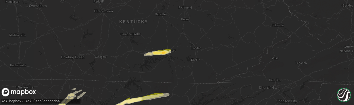
Hail Map in Somerset, KY on June 11, 2023
The weather event in Somerset, KY on June 11, 2023 includes Hail, Wind, and Tornado maps. 23 states and 920 cities were impacted and suffered possible damage. The total estimated number of properties impacted is 7,045.
Hail
Wind
Tornado
7,045
Estimated number of impacted properties by a 1.00" hail or larger2,747
Estimated number of impacted properties by a 1.75" hail or larger935
Estimated number of impacted properties by a 2.50" hail or largerStorm reports in Somerset, KY
Somerset, KY
| Date | Description |
|---|---|
| 06/11/20234:05 PM CDT | A tree was reported to have been blown down onto a residence. |
| 06/11/20234:04 PM CDT | A power line was reported down across elliott drive in somerset... Near loveless lane. |
| 06/11/20233:57 PM CDT | Trees were blown down and blocking the roadway at 2135 oak hill road |
| 06/11/20233:55 PM CDT | A local report indicates 1.25 inch wind near 1 N Somerset |
| 06/11/20233:54 PM CDT | A tree was reported down on house along paterson branch road. |
| 06/11/20233:51 PM CDT | Social media video shared to local media with hail to around golf ball size falling. The event time is radar estimated. |
| 06/11/20233:51 PM CDT | Corrects previous tstm wnd dmg report from 2 w somerset pulaski county. Trees were blown down and blocking the roadway at 2135 oak hill road |
| 06/11/20233:51 PM CDT | Large branches were reported in the roadway on grand central blvd near the intersection with grand circle southwest of somerset. |
| 06/11/20233:51 PM CDT | A power line was down in the yard of a residence at 1712 patterson branch road southwest of somerset. The pole was reported to have possibly been broken. |
| 06/11/20233:50 PM CDT | A tree was reported to have been blown down and blocking the roadway at 3010 simpson drive southeast of somerset. |
| 06/11/20233:50 PM CDT | A tree was rep tn 3641 8488 photo received via facebook of snapped power pole and downed trees. |
| 06/11/20233:49 PM CDT | A local report indicates 1.00 inch wind near Somerset |
| 06/11/20233:49 PM CDT | Social media picture shared from near the lees ford marina with hail to about golf ball size. The event time is radar estimated. |
| 06/11/20233:48 PM CDT | Report from mping: ping pong ball |
| 06/11/20233:44 PM CDT | Report from mping: quarter |
| 06/11/20233:43 PM CDT | What appears to be cable lines are laying across the road at 2341 slate branch road northwest of burnside. Time estimated by radar. |
All States Impacted by Hail Map on June 11, 2023
All Cities Impacted by Hail Map on June 11, 2023
- Axtell, NE
- Minden, NE
- Chanute, KS
- Erie, KS
- Galesburg, KS
- Sandersville, GA
- Columbia, SC
- Elgin, SC
- Lugoff, SC
- Quinton, OK
- Red Oak, OK
- Kinta, OK
- Wilburton, OK
- Walsenburg, CO
- Hardaway, AL
- Tuskegee, AL
- Lebanon, TN
- Watertown, TN
- Brush Creek, TN
- Alexandria, TN
- Liberty, KY
- Elk Horn, KY
- Aguilar, CO
- Talihina, OK
- Wister, OK
- Charlotte, TN
- White Bluff, TN
- Ashland City, TN
- Albany, KY
- Baxter, TN
- Bloomington Springs, TN
- Gainesboro, TN
- Cookeville, TN
- Trinidad, CO
- Hustonville, KY
- Middleburg, KY
- Byrdstown, TN
- Monroe, TN
- Pall Mall, TN
- Monticello, KY
- Livingston, TN
- Rickman, TN
- Allred, TN
- Crawford, TN
- Alpine, TN
- Nancy, KY
- Somerset, KY
- Russell Springs, KY
- Ferguson, KY
- Windsor, KY
- Dunnville, KY
- Yosemite, KY
- Nashville, TN
- Madison, TN
- Old Hickory, TN
- Hendersonville, TN
- Jamestown, TN
- Wilder, TN
- Model, CO
- Littleton, CO
- Lone Tree, CO
- Sedalia, CO
- Grantville, GA
- Moreland, GA
- Luthersville, GA
- Castle Rock, CO
- Parker, CO
- Franktown, CO
- Allardt, TN
- Branson, CO
- Trinchera, CO
- Stuttgart, AR
- Hazen, AR
- De Valls Bluff, AR
- Roe, AR
- Sharpsburg, GA
- Newnan, GA
- Senoia, GA
- Clarendon, AR
- Altheimer, AR
- Wabbaseka, AR
- Elizabeth, CO
- Holly Grove, AR
- Crossville, TN
- Crab Orchard, TN
- Rockwood, TN
- Proctor, AR
- Helenwood, TN
- Huntsville, TN
- Wynne, AR
- Walls, MS
- Abilene, TX
- Buffalo Gap, TX
- Tuscola, TX
- Pioneer, TN
- Oneida, TN
- Horn Lake, MS
- Byhalia, MS
- Red Banks, MS
- Trumann, AR
- Marked Tree, AR
- Oakdale, TN
- Wartburg, TN
- Tyronza, AR
- Lepanto, AR
- Brinkley, AR
- Aubrey, AR
- Oliver Springs, TN
- Harriman, TN
- Newcomb, TN
- Morrilton, AR
- La Follette, TN
- Plumerville, AR
- Kim, CO
- Dryden, TX
- Southaven, MS
- Clyde, TX
- Joiner, AR
- Dyess, AR
- Albany, TX
- Greenbrier, AR
- Conway, AR
- Gouldbusk, TX
- Coleman, TX
- Santa Anna, TX
- Lake Cormorant, MS
- Weatherford, TX
- Nesbit, MS
- Tipp City, OH
- De Witt, AR
- Gillett, AR
- Kings Mountain, KY
- Waynesburg, KY
- Statesboro, GA
- Metter, GA
- Register, GA
- Springfield, TN
- White House, TN
- Cherry Valley, AR
- Hickory Ridge, AR
- Stanton, TN
- Hogansville, GA
- Lagrange, GA
- Carthage, TN
- Louviers, CO
- Flippin, AR
- Lake George, CO
- Lyons, GA
- Swainsboro, GA
- Midville, GA
- Crane, MO
- Marionville, MO
- Billings, MO
- Dixon Springs, TN
- Riddleton, TN
- Hartsville, TN
- Fort Stockton, TX
- Greensburg, KY
- Campbellsville, KY
- Pleasant Shade, TN
- Guyton, GA
- Rocky Ford, GA
- Millen, GA
- Sylvania, GA
- Crab Orchard, KY
- Newport, AR
- Bradford, AR
- Hestand, KY
- Tompkinsville, KY
- Sparta, TN
- Humphrey, AR
- Marion, AR
- Ovalo, TX
- Jamestown, KY
- Garnett, SC
- Pineland, SC
- Moss, TN
- Whitleyville, TN
- Celina, TN
- Gay, GA
- Callahan, FL
- Beedeville, AR
- McCrory, AR
- Castalian Springs, TN
- Bethpage, TN
- Memphis, TN
- Olive Branch, MS
- Bloomingdale, GA
- Mount Juliet, TN
- Gallatin, TN
- Brigham City, UT
- Englewood, CO
- Dickson, TN
- Robbins, TN
- Headland, AL
- Brodhead, KY
- Hardyville, KY
- Knifley, KY
- Columbia, KY
- Dardanelle, AR
- Woodbury, TN
- Monterey, TN
- Milton, TN
- Lascassas, TN
- Allons, TN
- Valera, TX
- Hilham, TN
- Red Boiling Springs, TN
- Lafayette, TN
- Burkesville, KY
- Heth, AR
- Midway, GA
- Hilliard, FL
- Edmonton, KY
- Portland, TN
- Spring City, TN
- Mccurtain, OK
- Whitesboro, OK
- Notasulga, AL
- Auburn, AL
- Hermitage, TN
- Pegram, TN
- Norton, TX
- Mount Vernon, KY
- Cobbtown, GA
- Buffalo Valley, TN
- Ulm, AR
- Carlisle, AR
- Crawfordsville, AR
- Estill, SC
- Tillman, SC
- Parkin, AR
- Hickman, TN
- Gordonsville, TN
- Hobe Sound, FL
- Mason, TN
- Grenville, NM
- Folsom, NM
- Gould, AR
- Sunbright, TN
- Watson, AR
- Tichnor, AR
- Evensville, TN
- Hernando, MS
- Lenoir City, TN
- Knoxville, TN
- Farragut, TN
- Rochelle, TX
- Clinton, TN
- Briceville, TN
- Michie, TN
- Counce, TN
- Coldwater, MS
- Boise, ID
- Courtland, MS
- Batesville, MS
- Fort Worth, TX
- Azle, TX
- Oxford, MS
- Rohwer, AR
- Benoit, MS
- Merkel, TX
- Hawley, TX
- Almyra, AR
- Hereford, TX
- Adrian, TX
- Taylor, MS
- Potts Camp, MS
- Myrtle, MS
- Water Valley, MS
- Marianna, AR
- Rockwall, TX
- Royse City, TX
- Tunica, MS
- New Albany, MS
- Pontotoc, MS
- Roanoke, TX
- Ecru, MS
- Blue Springs, MS
- Southlake, TX
- Flower Mound, TX
- Anson, TX
- Lueders, TX
- Boise City, OK
- Kenton, OK
- Thaxton, MS
- Randolph, MS
- Moran, TX
- Breckenridge, TX
- Ethel, AR
- Snow Lake, AR
- Gunnison, MS
- Belden, MS
- Cisco, TX
- Lohn, TX
- Naval Air Station Jrb, TX
- Tupelo, MS
- Argyle, TX
- Lewisville, TX
- Toccoa, GA
- Eastanollee, GA
- Cranks, KY
- Pennington Gap, VA
- Rosedale, MS
- Merigold, MS
- Mound Bayou, MS
- Vega, TX
- Wildorado, TX
- Dallas, TX
- Canyon, TX
- Happy, TX
- Banner, MS
- Bruce, MS
- Granbury, TX
- Godley, TX
- Cleburne, TX
- Capulin, NM
- Des Moines, NM
- Raton, NM
- Strawn, TX
- Graford, TX
- Palo Pinto, TX
- Lake Dallas, TX
- Beulah, MS
- The Colony, TX
- Carrollton, TX
- Plano, TX
- Jasper, GA
- Marble Hill, GA
- Dawsonville, GA
- Frisco, TX
- Grandview, TX
- Rio Vista, TX
- Mineral Wells, TX
- Allen, TX
- Covington, TX
- Mckinney, TX
- Ennis, TX
- Waxahachie, TX
- Keyes, OK
- Amarillo, TX
- Tulia, TX
- Perrin, TX
- Joshua, TX
- Crowley, TX
- Silverton, TX
- Barry, TX
- Italy, TX
- Blooming Grove, TX
- Corsicana, TX
- Poolville, TX
- Clayton, NM
- Springtown, TX
- Agate, CO
- Limon, CO
- Matheson, CO
- Burleson, TX
- Purdon, TX
- Texhoma, OK
- Goodwell, OK
- Cleveland, MS
- Boyle, MS
- Shaw, MS
- Indianola, MS
- Clarendon, TX
- Quitaque, TX
- Boyd, TX
- Paradise, TX
- Tolar, TX
- Rhome, TX
- Glen Rose, TX
- Moorhead, MS
- Greenville, TX
- Honey Grove, TX
- Ladonia, TX
- Roxton, TX
- Caddo Mills, TX
- Pecan Gap, TX
- Paris, TX
- Pattonville, TX
- Rainbow, TX
- Aquilla, TX
- Abbott, TX
- West, TX
- Deport, TX
- Lake Creek, TX
- Penelope, TX
- Mount Calm, TX
- Sulphur Bluff, TX
- Cooper, TX
- Childress, TX
- Turkey, TX
- Felt, OK
- Clarksville, TX
- Idabel, OK
- Haworth, OK
- Blum, TX
- Kopperl, TX
- Axtell, TX
- Hubbard, TX
- Bogata, TX
- Miami, NM
- Springer, NM
- Greenville, MS
- Leland, MS
- Mart, TX
- Dalhart, TX
- Whitney, TX
- Tell, TX
- Stratford, TX
- Morgan, TX
- Clifton, TX
- Valley Mills, TX
- Aspermont, TX
- Hollandale, MS
- Waco, TX
- China Spring, TX
- Anguilla, MS
- Belzoni, MS
- Louise, MS
- Hampton, AR
- Sarah, MS
- Crenshaw, MS
- Kiowa, CO
- Winfield, TN
- Sparkman, AR
- Camden, AR
- McRae Helena, GA
- Glenwood, GA
- Sledge, MS
- Dacula, GA
- Maxwell, NM
- Covington, TN
- Riverside, OR
- Springfield, GA
- Haleyville, AL
- Phil Campbell, AL
- Waynesboro, TN
- Clifton, TN
- Bath Springs, TN
- Bronston, KY
- Colt, AR
- Howard, CO
- Claxton, GA
- Millsap, TX
- Senatobia, MS
- Como, MS
- Sardis, MS
- Lawrenceville, GA
- Loxahatchee, FL
- Blossom, TX
- Detroit, TX
- Kingston, TN
- Pritchett, CO
- Mesquite, TX
- Princeton, TX
- Milliken, CO
- Ranger, TX
- Rienzi, MS
- Gordon, TX
- Baird, TX
- Caddo, TX
- Jacksonville, FL
- Richmond Hill, GA
- Guffey, CO
- Kingston Springs, TN
- Fairview, TN
- Augusta, AR
- Gurdon, AR
- Rowlett, TX
- Lula, GA
- Alto, GA
- Cornelia, GA
- Coppell, TX
- Washington, AR
- Columbus, AR
- Fulton, AR
- Wylie, TX
- Quinlan, TX
- Nevada, TX
- Rosie, AR
- Oil Trough, AR
- Thida, AR
- Magness, AR
- Fernandina Beach, FL
- Newville, AL
- Abbeville, AL
- Columbia, AL
- Ten Mile, TN
- Dayton, TN
- Ball Ground, GA
- Moro, AR
- Palestine, AR
- Talpa, TX
- Decaturville, TN
- Bairoil, WY
- Simla, CO
- Philadelphia, TN
- Loudon, TN
- Houlka, MS
- Houston, MS
- Fleming, GA
- Cotopaxi, CO
- Dundee, MS
- Holly Springs, MS
- Grapevine, TX
- Russellville, AL
- Helena, AR
- Marvell, AR
- Lexa, AR
- Poplar Grove, AR
- Cordova, TN
- Ramah, CO
- Lawrenceburg, TN
- Summertown, TN
- Ethridge, TN
- Belmont, MS
- Foreman, AR
- Ashdown, AR
- Palmer, TX
- Townville, SC
- Norcross, GA
- Lilburn, GA
- Dahlonega, GA
- Waterford, MS
- Garland, TX
- Baldwin, GA
- Tishomingo, MS
- Cherokee, AL
- Greenville, GA
- Keller, TX
- Cumming, GA
- Jellico, TN
- Duff, TN
- Drummonds, TN
- Rocky Top, TN
- Rockwood, TX
- Paris, ID
- Little Elm, TX
- Chidester, AR
- Twin Falls, ID
- Delta, UT
- Bard, NM
- Munford, TN
- Atoka, TN
- Bagwell, TX
- Red Oak, TX
- Grand Prairie, TX
- Irving, TX
- Mountain View, AR
- Dennis, MS
- Red Bay, AL
- Hickory Flat, MS
- Blue Mountain, MS
- Brighton, TN
- Lancing, TN
- Glennville, GA
- Aurora, CO
- Tarrytown, GA
- Vidalia, GA
- Dumas, AR
- Murrayville, GA
- Cleveland, GA
- Saltillo, MS
- Mantachie, MS
- Mooreville, MS
- Osceola, AR
- Etowah, AR
- Etta, MS
- Abbeville, MS
- Paris, MS
- Rising Star, TX
- Peachtree City, GA
- Sumner, TX
- Arlington, TX
- Mansfield, TX
- Cedar Hill, TX
- Midlothian, TX
- Spruce Pine, AL
- Iuka, MS
- Bearden, AR
- Alamo, GA
- Fairmount, GA
- Rydal, GA
- Cascade, ID
- West Helena, AR
- Oak Ridge, TN
- Melbourne, AR
- Batesville, AR
- Fifty Six, AR
- Pleasant Grove, AR
- Clarkesville, GA
- Demorest, GA
- Tillar, AR
- England, AR
- Lonoke, AR
- Franklin, TN
- Farmersville, TX
- Westpoint, TN
- Niota, TN
- Decatur, TN
- Bluff City, AR
- Prescott, AR
- Powell, TN
- Heiskell, TN
- Earle, AR
- Kingsland, AR
- Sunnyvale, TX
- Bloomington, ID
- Guys, TN
- Winthrop, AR
- Grimsley, TN
- Guntown, MS
- Weston, CO
- Savannah, GA
- Pooler, GA
- Waterloo, AL
- Hinesville, GA
- Mount Airy, GA
- Mount Vernon, GA
- Soperton, GA
- Brickeys, AR
- Robinsonville, MS
- Booneville, MS
- Corinth, MS
- Okolona, MS
- Williamsburg, KY
- Cresson, TX
- Wingate, TX
- Winters, TX
- Bunnell, FL
- Nettleton, MS
- Canon City, CO
- Elmwood, TN
- Auburntown, TN
- Screven, GA
- Sachse, TX
- Lavon, TX
- Grandview, TN
- Boswell, OK
- Vardaman, MS
- Pittsboro, MS
- Lancaster, TX
- Tate, GA
- Marks, MS
- Newark, TX
- Germantown, TN
- Eads, TN
- Collierville, TN
- Bryceville, FL
- Andersonville, TN
- Thornton, AR
- Arthur City, TX
- Plantersville, MS
- Fulton, MS
- Shannon, MS
- Smithville, MS
- Amory, MS
- Corinne, UT
- Frenchmans Bayou, AR
- Bassett, AR
- Williamson, GA
- Brooks, GA
- Haslet, TX
- Widener, AR
- Hughes, AR
- Aledo, TX
- Dowelltown, TN
- Liberty, TN
- Ramer, TN
- Ludowici, GA
- Hugo, OK
- Venus, TX
- Kennedale, TX
- Alvarado, TX
- Old Glory, TX
- Elm Mott, TX
- Gruver, TX
- Texhoma, TX
- Rule, TX
- Stamford, TX
- Arkansas City, AR
- Gladstone, NM
- Inverness, MS
- Isola, MS
- Avoca, TX
- Demopolis, AL
- Sedan, NM
- Throckmorton, TX
- Texline, TX
- Mosquero, NM
- Nara Visa, NM
- Amistad, NM
- Hartley, TX
- Channing, TX
- Logan, NM
- Newcastle, TX
- Olney, TX
- Holliday, TX
- Ocate, NM
- Wagon Mound, NM
- Windthorst, TX
- Grady, AR
- Tellico Plains, TN
- Johnstown, CO
- Snellville, GA
- Grayson, GA
- Juntura, OR
- West Point, MS
- Prairie, MS
- Westminster, SC
- Union Point, GA
- Tuttle, OK
- Blanchard, OK
- Newcastle, OK
- Starkville, MS
- Cedarbluff, MS
- Columbus, MS
- Campbell, TX
- Snyder, TX
- Keiser, AR
- Ben Franklin, TX
- Nemo, TX
- Gardendale, AL
- Pope, MS
- Loretto, TN
- Deatsville, AL
- Marbury, AL
- McGehee, AR
- Martin, GA
- Oxford, AL
- Munford, AL
- Rincon, GA
- Hillsboro, TX
- Double Springs, AL
- Keene, TX
- Twain, CA
- Quincy, CA
- Guion, AR
- Calico Rock, AR
- Mount Pleasant, AR
- Eutaw, AL
- Boligee, AL
- De Kalb, MS
- Scooba, MS
- Pinson, AL
- Birmingham, AL
- Morris, AL
- Warrior, AL
- Mount Olive, AL
- Itasca, TX
- Mora, NM
- Cimarron, NM
- Norfork, AR
- Fair Play, SC
- Macon, MS
- Canton, GA
- Rotan, TX
- York, AL
- Cuba, AL
- Central, SC
- Anderson, SC
- Pendleton, SC
- Liberty, SC
- Clemson, SC
- Faunsdale, AL
- Woodland, MS
- Verbena, AL
- Jayton, TX
- Hugo, CO
- Houston, AL
- Pine Apple, AL
- Porterville, MS
- Casscoe, AR
- Aliceville, AL
- New Market, AL
- Carnesville, GA
- Tuskegee Institute, AL
- Louisville, GA
- Seneca, SC
- Lillian, TX
- Wayside, TX
- Trenton, TX
- Whitewright, TX
- Norman, OK
- Washington, OK
- Noble, OK
- Lexington, OK
- Mustang, OK
- Oklahoma City, OK
- Roy, NM
- Dumas, TX
- Sunray, TX
- Stinnett, TX
- Panhandle, TX
- Fritch, TX
- Masterson, TX
- Skellytown, TX
- Borger, TX
- Pampa, TX
- White Deer, TX
- Groom, TX
- Sayre, OK
- Carter, OK
- Elk City, OK
- Dill City, OK
- Canute, OK
- Hobart, OK
- Gotebo, OK
- Roosevelt, OK
- Mountain View, OK
- Carnegie, OK
- Hammon, OK
- Butler, OK
- Foss, OK
- Paoli, OK
- Pauls Valley, OK
- Stratford, OK
- Apache, OK
- Sentinel, OK
- Cordell, OK
- Clinton, OK
- Mclean, TX
- Lawton, OK
- Elgin, OK
- Shamrock, TX
- Fletcher, OK
- Rush Springs, OK
- Marlow, OK
- Erick, OK
- Temple, OK
- Walters, OK
- Comanche, OK
- Waurika, OK
- Ringling, OK
- Ryan, OK
- Verona, MS
- Science Hill, KY
- Norris, TN
- Maynardville, TN
- Cheyenne, OK
- Rainsville, NM
- Adrian, GA
- Kite, GA
- Wrightsville, GA
- Willow, OK
- Fitzhugh, OK
- Ada, OK
- Henrietta, TX
- Bellevue, TX
- Castleberry, AL
- Brewton, AL
- Fort Sill, OK
- Uniontown, AL
- Thomaston, AL
- Safford, AL
- Catherine, AL
- Purcell, OK
- Lone Wolf, OK
- Granite, OK
- Cyril, OK
- Newbern, AL
- Cement, OK
- Lindsay, OK
- Meigs, GA
- Sale City, GA
- Hartsfield, GA
- Camden, AL
- Fort Cobb, OK
- Pennington, AL
- Sweet Water, AL
- Linden, AL
- Bellamy, AL
- Livingston, AL
- Reydon, OK
- Annona, TX
- Arlington, AL
- Wilson, OK
- Hastings, OK
- Silver City, MS
- Rocky, OK
- Coy, AL
- Pine Hill, AL
- Hurtsboro, AL
- Hatchechubbee, AL
- Tallassee, AL
- Haskell, TX
- Celeste, TX
- Leonard, TX
- Weatherford, OK
- Arapaho, OK
- Denton, TX
- Shorter, AL
- Georgiana, AL
- Evergreen, AL
- McKenzie, AL
- Magnolia, AL
- Alberta, AL
- Byars, OK
- Wheeler, TX
- Minter, AL
- Gallion, AL
- Orrville, AL
- Pittsview, AL
- Sweetwater, OK
- Auburn, GA
- Anadarko, OK
- Miami, TX
- Canadian, TX
- Range, AL
- Lenox, AL
- Repton, AL
- Briscoe, TX
- Monroeville, AL
- Corn, OK
- Lower Peach Tree, AL
- Texola, OK
- Christiansburg, OH
- Saint Paris, OH
- York, PA


