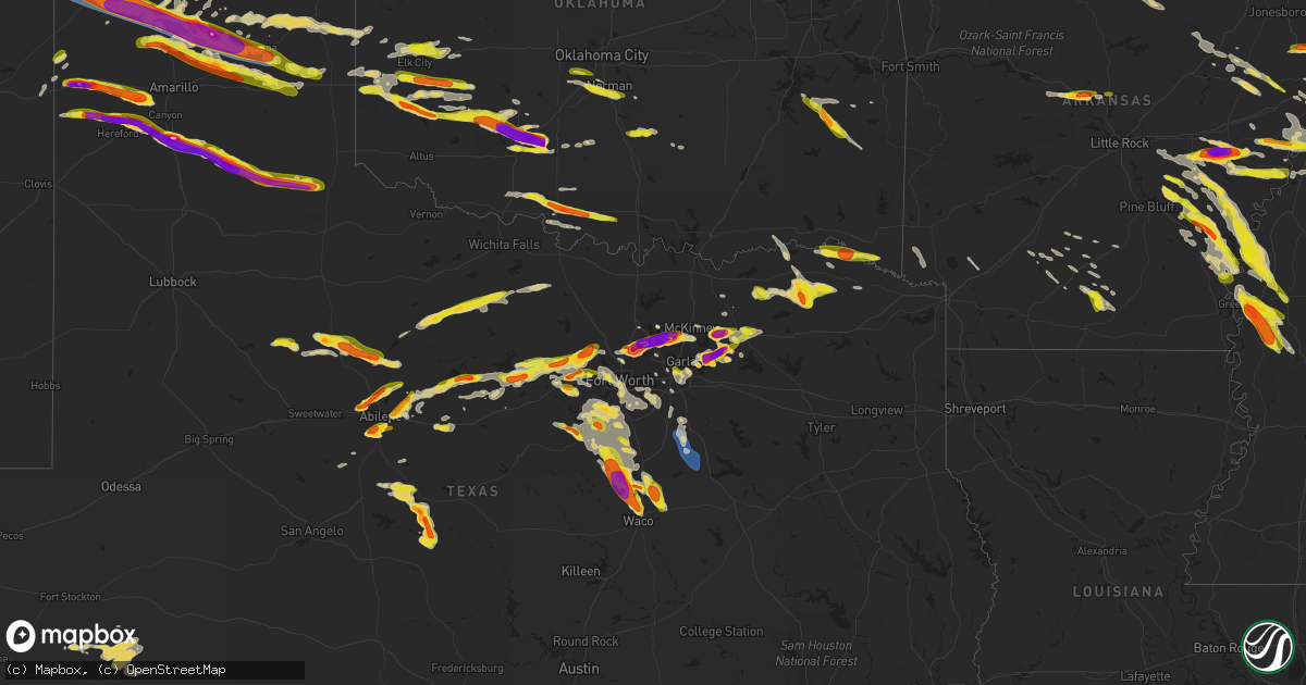
Hail Map on June 11, 2023
Get this storm
June 11 map
$229
one time, instant access
Download today. No call, no setup
Keep the $229
Bought the map and want the full workflow? Apply the entire $229 to a subscription within 7 days. None of it is wasted.
Every map, not just this one
This buys you this map. Subscription and you get every map we run, in the markets you choose from a few cities to whole states to nationwide. Plus real-time alerts the moment a storm fires.
Contact data
Name, contact info, occupancy, even credit band for addresses in the footprint. You go from where it hit to who to call.
Become the source they trust
Unlimited branding weather history reports on demand. You already have the documented answer ready for the property owner, and you are the one who showed up with it.
Property data and RoofTrace estimates
Pull up any address you have got, its value and the exact code rules for that jurisdiction, straight from One Click Code. Then RoofTrace estimates the squares, pitch, and roof value, priced the way you price.
States Impacted by Hail Map on June 11, 2023
Storm reports
Georgia
| Date | Description |
|---|---|
| 06/11/20236:32 PM CDT | 1 inch hail reported via social media on brisbane drive in dacula. |
| 06/11/20236:08 PM CDT | Tree down blocking roadway at intersection of navajo court and indian way. |
| 06/11/20236:08 PM CDT | Tree down blocking roadway at intersection of vinings court and paces vale place. |
| 06/11/20235:09 PM CDT | Thunderstorm wind damage with tree tops broken off and tree limbs down. Wind speed estimated. Time estimated from radar. |
| 06/11/20235:06 PM CDT | Tree down at the intersection of windgate road and robinson road. |
| 06/11/20235:06 PM CDT | Tree down at intersection of flat creek road and cloister drive. |
| 06/11/20235:02 PM CDT | One tree down in richmond hill. Time estimated from radar. |
| 06/11/20234:59 PM CDT | Tree down near intersection of wynnmeade pkwy and hwy 54. |
| 06/11/20234:49 PM CDT | Tree down at the interection of lawshe road and peeks crossing. |
| 06/11/20234:43 PM CDT | Corrects previous hail report from 4 e moreland. Ping pong sized hail reported via social media near hwy 54 and gordon road. |
| 06/11/20234:43 PM CDT | Tree down at intersection of dingler road and cline road. |
| 06/11/20234:43 PM CDT | Corrects previous hail report from 4 e moreland. Ping pong sized hail reported via social media near hwy 54 and gordon road. |
| 06/11/20234:36 PM CDT | Mping report of quarter sized hail in luthersville. |
| 06/11/20234:36 PM CDT | 2 inch hail reported via social media in moreland. |
| 06/11/20234:32 PM CDT | Tree fell on powerlines at intersection of bradbury and lowry road. |
| 06/11/20233:39 PM CDT | Effingham county warning point reported a tree down at 1500 block of green morgan school road. |
| 06/11/20233:34 PM CDT | Effingham county warning point reported a couple of trees down at the 400 block of shawnee egypt road. |
| 06/11/20232:49 PM CDT | Tree down at intersection of hillsboro cemetery road and hwy 280. |
| 06/11/20232:42 PM CDT | Screven county warning point reported multiple trees down on bascom road near country club road. |
| 06/11/20232:36 PM CDT | Tree down at intersection of jones street and clifton avenue. |
| 06/11/20232:36 PM CDT | Tree down at intersection of jones street and clifton avenue. |
| 06/11/20232:20 PM CDT | One downed tree reported on parks rd in millen... Ga. Time estimated from radar. |
| 06/11/20231:17 PM CDT | Tree down at intersection of old wadley road and r j holder road. |
| 06/11/20236:12 AM CDT | Tree down at merritt road and thigpen trail. |
| 06/11/20236:00 AM CDT | Numerous power outages in mitchell emc service area due to severe storms with downed and sagging power lines. |
| 06/11/20235:15 AM CDT | Tree down across old river rd near george solomon rd. Time estimated from report and radar. |
| 06/11/20234:51 AM CDT | Numerous power outages in mitchell emc service area due to severe storms with downed and sagging power lines. |
| 06/11/20234:41 AM CDT | Worth co 911 reports a power line down on pearson rd near woodcrest rd. |
| 06/11/20234:35 AM CDT | Large tree down on hwy 338 near campbell rd. |
| 06/11/20234:10 AM CDT | Three transformers blew near the publix. |
| 06/11/20233:55 AM CDT | A downed tree resulted in a power outage. |
| 06/11/202312:11 AM CDT | Report from mping: 1-inch tree limbs broken; shingles blown off. |
| 06/10/20237:55 PM CDT | Dime to half dollar size hail fell along new hope rd. |
| 06/10/20237:54 PM CDT | 1 inch hail report via social media near the intersection of steve tate highway and cove road. |
| 06/10/20237:19 PM CDT | Ping pong sized hail reported via social media near hwy 54 and gordon road. |
Virginia
| Date | Description |
|---|---|
| 06/10/20239:23 PM CDT | Tree down along balls chapel rd. Time estimated by radar. |
| 06/10/20238:15 PM CDT | Trees were blown down just west of pennington gap... Va. |
| 06/10/20237:15 PM CDT | A few trees down along baileytown road. Time estimated from radar. |
South Carolina
| Date | Description |
|---|---|
| 06/11/20234:39 PM CDT | Duke energy reported power outages from trees falling on power lines along hamilton rd. |
| 06/11/20234:20 PM CDT | Tree down at the 800 block of cooks hill road. |
| 06/11/20234:14 PM CDT | Tree down on 16721 hendersonville highway. Time estimated from radar. |
| 06/11/20234:11 PM CDT | Tree down at the 1700 block of hampton street. |
| 06/11/20234:08 PM CDT | Tree down at 705 poplar street in walterboro. Time estimated from radar. |
| 06/11/20234:05 PM CDT | Tree down at 1800 block of jefferies highway. |
| 06/11/20233:57 PM CDT | Duke energy reported |
| 06/11/20233:57 PM CDT | Duke energy reported power lines down causing outages along lewis rd near club ln in sumter. |
| 06/11/20233:53 PM CDT | Tree down at the 1500 block of hydrick road. |
| 06/11/20233:50 PM CDT | Tree down at the 4800 and 3300 block of hudson mill road. |
| 06/11/20233:39 PM CDT | Colleton county warning point reported a tree down on powerlines on the 2700 block of rum gully road. |
| 06/11/20233:30 PM CDT | Colleton county warning point reported a tree down at the 1600 block of broxton bridge highway. |
| 06/11/20233:18 PM CDT | One tree reported down in garnett. Time estimated from radar. |
| 06/11/20233:11 PM CDT | One tree down reported in brunson... Sc. Time estimated from radar. |
| 06/11/20232:00 PM CDT | Kershaw county dispatch reported trees down on powerlines at ward rd and us 1. Time estimated by radar. |
| 06/11/20231:55 PM CDT | Colleton county warning point reported one tree down at the intersection of lowcountry highway and miracle road and another tree down at lowcountry highway and broadway |
| 06/11/20231:42 PM CDT | Trained spotter reported trees on power lines along bookman rd near old two notch rd. Time estimated by radar. |
| 06/11/20231:42 PM CDT | Trained spotter reported trees on power lines orted to have been blown down and blocking the roadway at 3010 simpson drive southeast of somerset. |
| 06/11/20231:24 PM CDT | Richland county dispatch reported powerlines down at the intersection of heatherwood & cedarwood rd. Time estimated based on radar. |
| 06/11/20231:22 PM CDT | Richland county dispatch reported trees down at the intersection of lady st and assembly st. Time estimated from radar. |
| 06/11/20231:22 PM CDT | Fairfield county dispatch reported several trees and power lines down along smallstown rd near old chester rd. |
| 06/11/202312:40 PM CDT | Received a report of several large trees down 2 miles south of gilbert. Time estimated based on radar. |
| 06/10/202311:45 PM CDT | At least a couple of trees down in the vicinity o |
| 06/10/202311:45 PM CDT | At least a couple of trees down in the vicinity of i-85. |
| 06/10/202311:30 PM CDT | A tree was blown onto a power line. |
| 06/10/202311:15 PM CDT | A couple of trees were blown down. |
Tennessee
| Date | Description |
|---|---|
| 06/11/20236:55 PM CDT | Quarter sized hail reported near interstate 75. |
| 06/11/20236:52 PM CDT | A utility pole was snapped on drummonds road. |
| 06/11/20236:40 PM CDT | A few trees down near coal hill road and campground road intersection. Time estimated from radar. |
| 06/11/20236:38 PM CDT | Six power poles were severely bent on germantown parkway south of macon road. |
| 06/11/20236:35 PM CDT | Quarter sized hail fell for a couple of minutes. |
| 06/11/20236:35 PM CDT | Quarter sized hail fell for a couple of minutes. |
| 06/11/20236:28 PM CDT | Quarter size hail south of shiloh. |
| 06/11/20236:25 PM CDT | Trees down. |
| 06/11/20236:03 PM CDT | A local report indicates 60 MPH wind near 1 WSW Gladeville |
| 06/11/20235:55 PM CDT | Quarter sized hail reported in wartburg... Tn. |
| 06/11/20235:51 PM CDT | Photo received via facebook of damage caused by a large fallen tree at eastwood greene apartments. |
| 06/11/20235:50 PM CDT | Tree branches estimated to be two inches in diameter down near lebanon road and highway 109. Time estimated. |
| 06/11/20235:45 PM CDT | Quarter to half dollar sized hail reported in elk valley. |
| 06/11/20235:45 PM CDT | Downed trees off old hickory blvd. In brentwood. |
| 06/11/20235:40 PM CDT | Quarter to ping pong ball sized hail reported along highway 68. |
| 06/11/20235:20 PM CDT | Photo received via facebook of snapped tree. |
| 06/11/20235:11 PM CDT | Ef1 tornado in helenwood tn. From storm survey. Numerous trees down along russ lane. More trees uprooted on silcox ford road. |
| 06/11/20235:05 PM CDT | Photo received via facebook of roof damage at a home caused by a large fallen tree. |
| 06/11/20235:02 PM CDT | Photo received via facebook of tree down. |
| 06/11/20234:58 PM CDT | House significantly damaged. Tornado possible. |
| 06/11/20234:55 PM CDT | Photo received via facebook showing 1.5 inch hail. |
| 06/11/20234:55 PM CDT | Photo received via facebook showing 1.5 inch hail. |
| 06/11/20234:53 PM CDT | Photo received via facebook of snapped power pole and downed trees. |
| 06/11/20234:49 PM CDT | Trees uprooted or snapped; roof damaged. |
| 06/11/20234:49 PM CDT | Photo received via facebook of multiple trees down. |
| 06/11/20234:43 PM CDT | Report of possible tornado and multiple trees down. |
| 06/11/20234:17 PM CDT | Trees down completely blocking the road. |
| 06/11/20233:58 PM CDT | Twitter photo of quarter sized hail at old hickory country club. |
| 06/11/20233:58 PM CDT | Twitter report of downed tree at 24th and dabbs. Time estimated. |
| 06/11/20233:52 PM CDT | 1-inch hail reported via mping. |
| 06/11/20233:15 PM CDT | Multiple trees down along campground road at dale hollow dam campground. |
| 06/11/20233:06 PM CDT | Photo received via facebook of golf ball sized hail. |
| 06/11/20232:32 PM CDT | Photo received via facebook of ping pong sized hail. |
| 06/11/20232:24 PM CDT | 1.5 inch hail reported along neal road in watertown. |
| 06/11/20232:24 PM CDT | Corrects previous hail report from 1 se watertown. 1.5 inch hail reported along neal road in watertown. |
| 06/11/20232:10 PM CDT | Photo received via facebook of 1.00 inch hail. |
| 06/10/202310:15 PM CDT | Numerous trees and powerlines down in apison... Tn. Location at intersection of bill jones road... Park place and old east brainerd road. Pictures from social media. Ti |
| 06/10/20239:34 PM CDT | Trees down next to flex-n-gate company in rockford tn. Power poles broken. Reported by trained spotter. |
| 06/10/20239:25 PM CDT | Several trees down and damage to a porch in sweetwater. Homeowner sent pictures. Time estimated from radar. |
| 06/10/20239:10 PM CDT | Several trees blown down across knox county... With at least one blocking a roadway. |
| 06/10/20238:50 PM CDT | County dispatch reported multiple trees and power lines down in the county... Especially in the southern end of the county. Time estimated from radar. |
| 06/10/20238:50 PM CDT | Tree blown down blocking two lanes of road. |
| 06/10/20238:30 PM CDT | Trees down along cedar creek road. East of la follette. Time estimated by radar. |
| 06/10/20238:22 PM CDT | Multiple reports of downed trees and power outages around downtown knoxville through east knox county. |
| 06/10/20238:08 PM CDT | Numerous trees down in southern and southeast part of scott county. |
| 06/10/20237:55 PM CDT | Tree fell through home. |
| 06/10/20237:42 PM CDT | Photos received via facebook of a tree on top of a house. |
| 06/10/20237:00 PM CDT | Quarter to half dollar sized hail in norris... Tn. |
| 06/10/20237:00 PM CDT | Quarter sized hail reported at the intersection of lovell road and kingston pike. |
Texas
| Date | Description |
|---|---|
| 06/11/20236:53 PM CDT | Report from the intersection of county road 416 and wimberly road. |
| 06/11/20236:45 PM CDT | A local report indicates 1.75 inch wind near 2 SW Stith |
| 06/11/20236:45 PM CDT | A local report indicates 1.75 inch wind near 2 SW Stith |
| 06/11/20236:45 PM CDT | A picture of ping pong ball sized hail was posted on facebook. |
| 06/11/20236:45 PM CDT | A picture of ping pong ball sized hail was posted on facebook. |
| 06/11/20236:38 PM CDT | Photo of half dollar and golf ball size hail from social media. |
| 06/11/20236:31 PM CDT | Quarter hail reported in weatherford... Tx. |
| 06/11/20236:01 PM CDT | A local report indicates 1.50 inch wind near 1 ESE Potosi |
| 06/11/20235:45 PM CDT | A local report indicates 1.50 inch wind near Abilene |
| 06/11/20235:45 PM CDT | A local report indicates 1.75 inch wind near 5 NNE Buffalo Gap |
| 06/11/20235:44 PM CDT | A local report indicates 1.25 inch wind near 6 E View |
| 06/11/20235:28 PM CDT | A local report indicates 1.00 inch wind near 2 W Potosi |
| 06/11/20235:39 AM CDT | A local report indicates 1.75 inch wind near Panhandle |
| 06/11/20234:59 AM CDT | A local report indicates 2.50 inch wind near Fritch |
| 06/11/20234:59 AM CDT | Corrects report of tennis ball sized hail in fritch at the same time. |
| 06/11/20234:55 AM CDT | Photo was submitted via social media. |
| 06/11/20234:45 AM CDT | A local report indicates 1.50 inch wind near 3 SE Fritch |
| 06/11/20234:32 AM CDT | Photo submitted via social media. Time estimated on radar. |
| 06/11/20234:30 AM CDT | Photo submitted via social media. |
| 06/11/20234:30 AM CDT | Photo submitted via social media. |
| 06/11/20234:30 AM CDT | Photo submitted via social media. |
| 06/11/20234:13 AM CDT | Report from mping: hen egg |
| 06/11/20234:06 AM CDT | Photo was submitted via social media. |
| 06/11/20233:16 AM CDT | Report from social media with picture. Time estimated based off radar. |
| 06/11/20233:15 AM CDT | Photo of the hailstones were submitted on social media. |
| 06/11/20233:14 AM CDT | Broken windows and house damage within the town of dalhart. |
| 06/11/20233:12 AM CDT | Corrects previous hail report from 1 se dalhart. Hail started at 3:12 am and lasted through 3:17 am. |
| 06/11/20233:10 AM CDT | A local report indicates 71 MPH wind near 3 SW Dalhart |
| 06/11/202312:41 AM CDT | Trained spotter called in ping pong |
| 06/11/202312:35 AM CDT | Jones co. Sheriff called stating that a deputy south of stanford reported a possible tornado on ground... Rain wrapped and heading toward avoca... Tx. |
| 06/11/202312:28 AM CDT | Trained spotter called in golf ball size hail. |
| 06/10/202311:42 PM CDT | Received a report of a tree that had fallen onto a house in whitney. No information on injuries. |
| 06/10/202311:39 PM CDT | Corrects previous hail report from 8 ssw whitney. Two inch hail reported on fm 56... Two miles south of laguna park. |
| 06/10/202311:39 PM CDT | Two inch hail reported on fm 56... Two miles south of laguna park. |
| 06/10/202311:27 PM CDT | A local report indicates 60 MPH wind near 4 WNW Stratford |
| 06/10/202311:27 PM CDT | Report from mping of ping pong ball size hail. |
| 06/10/202311:25 PM CDT | Trained storm spotter reported two inch hail in whitney. |
| 06/10/202311:17 PM CDT | Report from mping of ping pong ball size hail. |
| 06/10/202311:10 PM CDT | Some accumulating up to half inch deep on side of the highway. |
| 06/10/202311:01 PM CDT | Corrects previous tstm wnd dmg report from bogata. A power line was downed in bogata... Setting a tree on fire. |
| 06/10/202310:49 PM CDT | A local report indicates 1.00 inch wind near 23 NNE Ware |
| 06/10/202310:15 PM CDT | A local report indicates 2.00 inch wind near 2 NNE Turkey |
| 06/10/202310:01 PM CDT | A power line was downed in bogata... Setting a tree on fire. |
| 06/10/20239:57 PM CDT | . |
| 06/10/20239:57 PM CDT | A local report indicates 1.25 inch wind near 4 NNE Caprock Canyons S |
| 06/10/20239:55 PM CDT | Reports of large trees and power lines down near emhouse... Tx to corbet... Tx. |
| 06/10/20239:54 PM CDT | Reports of golf ball hail in springtown. |
| 06/10/20239:42 PM CDT | Trained spotter reported 1 in hail in greenville. |
| 06/10/20239:38 PM CDT | Quarter size hail reported near joshua. |
| 06/10/20239:37 PM CDT | Delayed report. Pictures were posted to social media of golfball size hail that fell along highway 195 just west of highway 37 in the albion community. |
| 06/10/20239:35 PM CDT | Report of half inch to ping pong ball size hail near cr915 and fm1902. |
| 06/10/20239:31 PM CDT | Ping pong to baseball sized hail. |
| 06/10/20239:10 PM CDT | Delayed report. Two inch hail was reported in farmersville. Time estimated via radar. |
| 06/10/20239:09 PM CDT | Quarter size hail reported in downtown famersville... Tx by trained spotter. |
| 06/10/20239:04 PM CDT | West texas mesonet at vigo park. |
| 06/10/20239:00 PM CDT | Delayed report. A hail stone measuring 3.5 inches was reported at the intersection of main street and teel parkway in frisco. Report received via social media. Time est |
| 06/10/20238:55 PM CDT | Delayed report. Oblong 2.5 inch hail was reported via mping. |
| 06/10/20238:54 PM CDT | Fd reports 2 inch hail in frisco. |
| 06/10/20238:54 PM CDT | Reports of quarter to half dollar hail in the colony... Tx. |
| 06/10/20238:53 PM CDT | Delayed report. Golf ball size hail was reported via social media off of legacy drive in frisco. |
| 06/10/20238:50 PM CDT | Delayed report. Three inch hail was reported in the colony. |
| 06/10/20238:46 PM CDT | Several reports of quarter to golf ball hail near hackberry. |
| 06/10/20238:45 PM CDT | Report of tennis ball to baseball size hail in the colony east of lewisville lake. |
| 06/10/20238:39 PM CDT | Trained spotter reported 3.5 in hail in bartonville |
| 06/10/20238:37 PM CDT | Delayed report. Report of ping pong ball size hail was received via mping. |
| 06/10/20238:30 PM CDT | Fire chief report. |
| 06/10/20238:29 PM CDT | Report of 2.75 in to 3 inch hail in highland village |
| 06/10/20238:29 PM CDT | A local report indicates 2.00 inch wind near 1 WSW Happy |
| 06/10/20238:29 PM CDT | West texas mesonet at happy 1e. |
| 06/10/20238:28 PM CDT | Report of quarter |
| 06/10/20238:28 PM CDT | Report of tennis ball |
| 06/10/20238:27 PM CDT | A local report indicates 1.25 inch wind near Happy |
| 06/10/20238:25 PM CDT | Report and picture relayed via social media. |
| 06/10/20238:25 PM CDT | Report and picture relayed via social media. |
| 06/10/20238:25 PM CDT | Photo was submitted via social media. |
| 06/10/20238:22 PM CDT | A local report indicates 2.75 inch wind near 1 WSW Happy |
| 06/10/20238:21 PM CDT | Report of up to golf ball |
| 06/10/20238:20 PM CDT | Report via social media with damaged windshield. |
| 06/10/20238:20 PM CDT | Delayed report. 2 inch hail reported in highland village. |
| 06/10/20238:20 PM CDT | Photo shared via social media of 4.25 inch hail near the inn springtown. |
| 06/10/20238:20 PM CDT | Photo shared via social media of 4.25 inch hail near the intersection of cross timbers rd and shiloh rd in flower mound. |
| 06/10/20238:15 PM CDT | Trained spotter reports of quarter to tennis ball hail in flower mound. |
| 06/10/20238:15 PM CDT | A local report indicates 4.00 inch wind near Flower Mound |
| 06/10/20238:13 PM CDT | Reports of hail up to golf ball size |
| 06/10/20238:05 PM CDT | Report of ping pong to golf ball hail in trophy club. |
| 06/10/20238:05 PM CDT | Report of half dollar |
| 06/10/20238:03 PM CDT | Delayed report. Half dollar size hail was reported via mping. |
| 06/10/20238:00 PM CDT | Quarter to golf ball size hail reported in trophy club near hwy 114 and 170. |
| 06/10/20238:00 PM CDT | Report of golf ball |
| 06/10/20238:00 PM CDT | Delayed report. Half dollar to golf ball size hail was reported in roanoke. |
| 06/10/20237:59 PM CDT | Report of hail up to ping pong balls nw of roanoke. |
| 06/10/20237:58 PM CDT | Report of half dollar |
| 06/10/20237:56 PM CDT | Reports of quarter sized hail in dallas ne of university park. |
| 06/10/20237:56 PM CDT | Report of half dollar |
| 06/10/20237:56 PM CDT | Trained spotter reports quarter sized hail in downtown godley. |
| 06/10/20237:50 PM CDT | Mesonet site reported 58 mph winds at 7:52 pm cdt. |
| 06/10/20237:50 PM CDT | Report of quarter |
| 06/10/20237:48 PM CDT | Report was via social media with hail up to ping pong ball size. |
| 06/10/20237:45 PM CDT | A local report indicates 1.00 inch wind near 2 SW Vega |
| 06/10/20237:44 PM CDT | Delayed report. 2 inch hail reported about 1 mile ne of downtown rockwall. |
| 06/10/20237:43 PM CDT | Photo on social media and reports of quarter to near baseball size hail in royse city. |
| 06/10/20237:42 PM CDT | Report of quarter size hail near westworth. Tersection of cross timbers rd and shiloh rd in flower mound. |
| 06/10/20237:42 PM CDT | Corrects the time of the previous hail report from hawley. Ham radio operator received a report of 1 hail in hawley. |
| 06/10/20237:42 PM CDT | Report of quarter |
| 06/10/20237:40 PM CDT | Delayed report. Ping pong ball size hail was reported in fate. |
| 06/10/20237:40 PM CDT | Delayed report. Tennis ball size hail was reported in roanoke via social media. |
| 06/10/20237:35 PM CDT | Several reports of ping pong ball size hail up to hen egg+ |
| 06/10/20237:35 PM CDT | Report of 2.25 inch hail near fate... Tx. |
| 06/10/20237:33 PM CDT | Delayed report. Quarter size hail was reported at the corner of highway 276 and faircrest drive in rockwall. |
| 06/10/20237:30 PM CDT | Report of several measured golf ball to ping pong ball size hail stones south of i-30 near the intersection of fm548 and rowdy dr. |
| 06/10/20237:30 PM CDT | Fort worth nas...tx |
| 06/10/20237:24 PM CDT | Report made via social media. |
| 06/10/20237:24 PM CDT | Report of quarters to golf ball hail in rockwall. |
| 06/10/20237:24 PM CDT | Report via social media with hail between half-dollar to ping pong ball size hail. |
| 06/10/20237:15 PM CDT | Report via social media with estimates of tennis to baseball sized hail. No picture to confirm. |
| 06/10/20237:13 PM CDT | A local report indicates 1.75 inch wind near Hawley |
| 06/10/20237:07 PM CDT | Report via social media... No picture to confirm. Tennis to baseball size hail fell around 8 miles southwest of adrian. |
| 06/10/20237:02 PM CDT | Photo of quarter sized hail n of aledo on social media. |
| 06/10/20237:00 PM CDT | Baseball hail broke vehicle windshield. |
Mississippi
| Date | Description |
|---|---|
| 06/11/20236:48 PM CDT | Quarter size hail at getwell road and byhalia road and malone road and byhalia road. |
| 06/11/20236:48 PM CDT | Golfball size hail fell at the panola county medical center. |
| 06/11/20236:47 PM CDT | Quarter size hail fell south of sarah. |
| 06/11/20236:45 PM CDT | Quarter size hail just south of batesville. |
| 06/11/20236:10 PM CDT | A utility pole and some power lines were knocked down along old highway 4. |
| 06/11/20235:50 PM CDT | Golf ball sized hail fell at highway 51 and nail road. |
| 06/11/20235:46 PM CDT | Egg sized hail fell in horn lake. |
| 06/11/20235:35 PM CDT | A local report indicates 1.25 inch wind near 2 N Walls |
| 06/11/20235:35 PM CDT | A local report indicates 1.00 inch wind near 1 NNW Walls |
| 06/11/20235:35 PM CDT | Corrects previous hail report from 1 nnw walls. Quarter size hail at goodman road and delta bluffs parkway. |
| 06/11/202310:54 AM CDT | Washington county so reported damage at the holiday inn and trees down near greenville. |
| 06/10/202310:54 PM CDT | Corrects previous tstm wnd dmg report from 3 ese greenville. Washington county so reported damage at the holiday inn and trees down near greenville. |
| 06/10/202310:54 PM CDT | Washington county so reported a few trees down along wilmont rd. |
| 06/10/202310:32 PM CDT | Lowndes county so reported multiple trees and power lines down near the 10 block of schlater rd. |
| 06/10/202310:24 PM CDT | Mping reports wind damage similar to tree limbs broken and shingles blown off near token rd. |
| 06/10/202310:22 PM CDT | Mping reports wind damage similar to tree limbs broken and shingles blown off near starkville. |
| 06/10/202310:12 PM CDT | Corrects previous tstm wnd dmg report from 1 nnw starkville. Large tree limb is down in the roadway on earnest jones dr. |
| 06/10/202310:12 PM CDT | Tree is down in the roadway on earnest jones dr. |
| 06/10/20239:50 PM CDT | Clay county dispatch reported multiple trees down along natchez trace pkwy. |
| 06/10/20239:45 PM CDT | An uprooted tree destroyed a manufactured home. |
| 06/10/20239:42 PM CDT | Trees down on two vehicles on jackson street. |
| 06/10/20239:40 PM CDT | Trees down across anchor road. Powerlines down. |
| 06/10/20239:38 PM CDT | Tree knocked down across county road 424 west of houston. |
| 06/10/20239:38 PM CDT | Large tree down on a home in the woodland area. |
| 06/10/20239:38 PM CDT | Significant damage to a manufactured home on county road 416. |
| 06/10/20239:30 PM CDT | A local report indicates 1.25 inch wind near 1 SSW Symonds |
| 06/10/20238:39 PM CDT | Significant damage to three greenhouses with minor damage to others on cardsville church road. Roof torn from a house. Tornado debris signature was evident on kgwx 88d |
| 06/10/20238:20 PM CDT | Corrects previous tstm wnd dmg report from 2 e tupelo. Trees and power lines down in central tupelo. One tree on a house with minor injuries. |
| 06/10/20238:18 PM CDT | Quarter size hail fell in the southern part of tupelo. |
| 06/10/20238:18 PM CDT | Spotter reports shutter damage to a home in southwest tupelo. A few large tree branches down. |
| 06/10/20238:05 PM CDT | A local report indicates 1.00 inch wind near Banner |
| 06/10/20237:55 PM CDT | Trees down on county road 268. |
| 06/10/20237:53 PM CDT | A local report indicates 1.25 inch wind near 1 ENE Crenshaw |
| 06/10/20237:51 PM CDT | Quarter size hail reported on highway 61 in tunica. |
| 06/10/20237:41 PM CDT | Quarter size hail fell in ingomar. |
| 06/10/20237:38 PM CDT | Ping pong size hail fell near new albany. |
| 06/10/20237:38 PM CDT | Ping pong size hail fell near new albany. |
| 06/10/20237:36 PM CDT | Quarter size hail fell in the martintown area. |
| 06/10/20237:31 PM CDT | Broken utility pole and downed lines along highway 30 near county road 56 west of new albany. |
| 06/10/20237:25 PM CDT | Quarter size hail fell in the lakes subdivision near oxford. |
| 06/10/20237:21 PM CDT | Half dollar size hail fell along highway 349 near cornersville. |
| 06/10/20237:21 PM CDT | Tree and powerline down at tate-marshall road at clanton road. |
| 06/10/20237:17 PM CDT | Ping pong ball size hail fell at the intersection of highway 331 and highway 334. |
| 06/10/20237:15 PM CDT | A local report indicates 1.75 inch wind near 5 SE Oxford |
| 06/10/20237:05 PM CDT | Trees down in the independence area. Trees down across sycamore road and highway 305 at independence road. |
Florida
| Date | Description |
|---|---|
| 06/11/20236:14 PM CDT | Awos station knrb mayport naval station. |
| 06/11/20235:50 PM CDT | Delayed report: photos shared from the public of a tree snapped on private property. Another image also shows downburst-like cloud signature over the area. Time estimat |
Colorado
| Date | Description |
|---|---|
| 06/11/20235:39 PM CDT | A local report indicates 1.25 inch wind near 16 NE Branson |
| 06/11/20235:39 PM CDT | A local report indicates 1.25 inch wind near 16 NE Branson |
| 06/11/20234:20 PM CDT | Corrects previous hail report from 2 nnw model. |
| 06/11/20234:20 PM CDT | Corrects previous hail report from 2 nnw model. |
| 06/11/20234:03 PM CDT | A local report indicates 1.00 inch wind near 4 ENE Hoehne |
| 06/11/20234:02 PM CDT | Report from mping: ping pong ball |
| 06/11/20233:11 PM CDT | A local report indicates 1.25 inch wind near 4 N Aguilar |
| 06/11/20232:26 PM CDT | A local report indicates 1.00 inch wind near 8 NE Spanish Peaks |
| 06/10/202311:30 PM CDT | Hail accumulation 6-8 deep. |
| 06/10/202310:30 PM CDT | Accumulated 3-4 deep on highway 24. |
| 06/10/202310:14 PM CDT | A local report indicates 1.50 inch wind near 8 ENE Matheson |
| 06/10/20238:56 PM CDT | Report from mping: quarter |
Alabama
| Date | Description |
|---|---|
| 06/11/20234:45 PM CDT | High winds caused numerous power outages due to tree limbs and other debris blowing into power lines. |
| 06/11/20232:14 PM CDT | A few trees were blown down on us 80 east of tuskegee. |
| 06/11/20234:19 AM CDT | Henry co dispatch reports trees down on hwy 95 between 37 and cr214. |
| 06/11/20234:19 AM CDT | Henry co dispatch reports trees down on 431 between cr 133 and 214. |
| 06/11/20231:39 AM CDT | Trees blown down in and around tuskegee. |
| 06/11/20231:30 AM CDT | Trees blown down in the franklin community. |
| 06/11/20231:18 AM CDT | Multiple trees down at hwy 66 and cr 109 near central mills via social media. |
| 06/10/202311:40 PM CDT | Tree down reports in various locations across shelby county. |
| 06/10/202311:20 PM CDT | Tree on house on riverchase pkwy. |
| 06/10/202311:12 PM CDT | Reports of trees down near shades crest road. |
| 06/10/202311:12 PM CDT | Numerous reports of trees down in the hoover/vestavia hills area. |
| 06/10/202310:35 PM CDT | Trees down around springville. |
| 06/10/20239:38 PM CDT | Tree down on highway 129 near hubbertville high school. Another tree down on highway 102. |
| 06/10/20239:28 PM CDT | Roof damage and power lines down in winfield. |
| 06/10/20239:26 PM CDT | Power lines down along beaver creek road and trees down near vernon. |
| 06/10/20239:14 PM CDT | Large tree branch down blocking part of the road. |
| 06/10/20239:11 PM CDT | Tree down blocking wall rd near hwy 72e. Time estimated by radar. |
| 06/10/20239:02 PM CDT | Power lines down on county road 43. |
| 06/10/20239:00 PM CDT | Tree snapped in half along dug hill road. Photo via social media. |
| 06/10/20239:00 PM CDT | Power line down along st. Clair ave. |
| 06/10/20239:00 PM CDT | Power line down along lowe ave. |
| 06/10/20239:00 PM CDT | Tree down on back patio at whnt. |
| 06/10/20239:00 PM CDT | Trees down in sw marion county. Tree across road in vicinity of highway 19. Power outages reported in area. |
| 06/10/20239:00 PM CDT | Tree down along shady ln dr. Time estimated based on radar. |
| 06/10/20239:00 PM CDT | Tree down on house at intersection of russel and rison. |
| 06/10/20239:00 PM CDT | Power line down near oakwood and minor. |
| 06/10/20239:00 PM CDT | Tree down near montdale rd and big cove dr. |
| 06/10/20239:00 PM CDT | Power line down at university and pulaski pike. |
Oklahoma
| Date | Description |
|---|---|
| 06/11/20232:55 PM CDT | A local report indicates 1.00 inch wind near Bengal |
| 06/11/20232:28 PM CDT | Observer saw a few large hailstones lying in grassy areas on the side of us 270. Hail was not falling at that time... Only rain. Hail time was estimated by radar at the |
| 06/11/20236:55 AM CDT | Time estimated by radar. |
| 06/11/20236:45 AM CDT | A local report indicates 2.50 inch wind near Fletcher |
| 06/11/20236:45 AM CDT | A local report indicates 2.50 inch wind near Elgin |
| 06/11/20236:45 AM CDT | A local report indicates 1.75 inch wind near Elgin |
| 06/11/20236:40 AM CDT | Time estimated. Porter hill... Ok. |
| 06/11/20236:40 AM CDT | A local report indicates 1.75 inch wind near Apache |
| 06/11/20236:40 AM CDT | Time estimated. |
| 06/11/20236:15 AM CDT | A local report indicates 1.25 inch wind near 9 W Boone |
| 06/11/20235:02 AM CDT | Report from mping: ping pong ball |
| 06/11/20235:00 AM CDT | Delayed report. |
| 06/11/20235:00 AM CDT | Report from mping: quarter |
| 06/11/20234:59 AM CDT | Multiple reports in southeast norman. |
| 06/11/20234:52 AM CDT | A local report indicates 1.75 inch wind near Willow |
| 06/10/202310:40 PM CDT | Mostly quarter with a few half dollars. |
| 06/10/202310:13 PM CDT | A local report indicates 2.00 inch wind near 3 W Felt |
| 06/10/202310:13 PM CDT | Report from social media with picture. Time estimated based on radar. |
| 06/10/202310:13 PM CDT | Hail made holes through the skylights in county barn; knocked out windows on the west side of a building; knocked out windows of some cars... Including the front and ba |
| 06/10/20239:59 PM CDT | A local report indicates 1.00 inch wind near 5 NW Harris |
| 06/10/20238:50 PM CDT | A local report indicates 58 MPH wind near 3 SSE Boise City |
| 06/10/20238:30 PM CDT | A local report indicates 1.50 inch wind near 5 N Boise City |
| 06/10/20237:48 PM CDT | A local report indicates 2.50 inch wind near 5 NE Black Mesa Park |
| 06/10/20237:48 PM CDT | A local report indicates 2.50 inch wind near 5 NE Black Mesa Park |
| 06/10/20237:43 PM CDT | A local report indicates 2.00 inch wind near 4 NNE Black Mesa Park |
| 06/10/20237:35 PM CDT | A local report indicates 1.00 inch wind near 5 N Kenton |
Idaho
| Date | Description |
|---|---|
| 06/11/20236:33 PM CDT | Heavy rain mixed with large hail. |
Kentucky
| Date | Description |
|---|---|
| 06/11/20236:46 PM CDT | A tree was blown down along ky 92 in this vicinity. |
| 06/11/20236:43 PM CDT | A tree was blown down onto powerlines near 283 hubbard hollow road. |
| 06/11/20236:22 PM CDT | A tree was down near the intersection of ky 26 and new zion road and another tree was down nearby on new zion road. |
| 06/11/20236:13 PM CDT | A tree was blown down near the intersection of ky 895 and ky 204. |
| 06/11/20236:00 PM CDT | A tree was reported to have been blown down onto sandhill road. |
| 06/11/20235:29 PM CDT | Several trees and powerlines down over roadways in franklin. |
| 06/11/20235:10 PM CDT | A tree was reported to have been blown down onto ky 2392. |
| 06/11/20234:43 PM CDT | A tree was blown down onto ky3630 near dollar general. |
| 06/11/20234:19 PM CDT | A tree was reported to be leaning on power lines at 234 lanetown road |
| 06/11/20234:15 PM CDT | Trees were reported to have been blown down in and near livingston. |
| 06/11/20234:10 PM CDT | Trees were down in and near brodhead. The event time is radar estimated from occurrence of strongest velocity in the area. |
| 06/11/20234:05 PM CDT | A tree was reported to have been blown down onto a residence. |
| 06/11/20234:04 PM CDT | A power line was reported down across elliott drive in somerset... Near loveless lane. |
| 06/11/20234:02 PM CDT | Several trees were blown down in and near mount vernon including two trees down onto homes in mount vernon and one also down onto a vehicle. |
| 06/11/20233:59 PM CDT | A tree was reported to have been blown onto powerlines along mo hollow road. |
| 06/11/20233:58 PM CDT | A tree was reported to have been blown down onto powerlines along ky 167. |
| 06/11/20233:57 PM CDT | Trees were blown down and blocking the roadway at 2135 oak hill road |
| 06/11/20233:55 PM CDT | A local report indicates 1.25 inch wind near 1 N Somerset |
| 06/11/20233:54 PM CDT | A tree was reported down on house along paterson branch road. |
| 06/11/20233:53 PM CDT | A tree was reported down and across the road on hwy-1665... Near the intersection with burnetta road near the nancy community. |
| 06/11/20233:51 PM CDT | Corrects previous tstm wnd dmg report from 2 w somerset pulaski county. Trees were blown down and blocking the roadway at 2135 oak hill road |
| 06/11/20233:51 PM CDT | Large branches were reported in the roadway on grand central blvd near the intersection with grand circle southwest of somerset. |
| 06/11/20233:51 PM CDT | A power line was down in the yard of a residence at 1712 patterson branch road southwest of somerset. The pole was reported to have possibly been broken. |
| 06/11/20233:51 PM CDT | Social media video shared to local media with hail to around golf ball size falling. The event time is radar estimated. |
| 06/11/20233:50 PM CDT | A tree was reported to have been blown down and blocking the roadway at 3010 simpson drive southeast of somerset. |
| 06/11/20233:50 PM CDT | A tree was rep tn 3641 8488 photo received via facebook of snapped power pole and downed trees. |
| 06/11/20233:49 PM CDT | Social media picture shared from near the lees ford marina with hail to about golf ball size. The event time is radar estimated. |
| 06/11/20233:49 PM CDT | A local report indicates 1.00 inch wind near Somerset |
| 06/11/20233:49 PM CDT | Public report via social media. The event time is radar estimated. |
| 06/11/20233:48 PM CDT | Report from mping: ping pong ball |
| 06/11/20233:44 PM CDT | Report from mping: quarter |
| 06/11/20233:43 PM CDT | Multiple social media reports from the nancy area of hail to at least tennis ball size as this was the largest size shared in an image. Roof and siding damage to a few |
| 06/11/20233:43 PM CDT | What appears to be cable lines are laying across the road at 2341 slate branch road northwest of burnside. Time estimated by radar. |
| 06/11/20233:43 PM CDT | Trees were reported down for about a mile along highway 1664 at pierce road just west of nancy. Many of the trees were partially rotten or small... And preliminary asse |
| 06/11/20233:42 PM CDT | Quarter |
| 06/11/20233:42 PM CDT | Several trees down over roadways in albany. |
| 06/11/20233:40 PM CDT | Corrects previous tstm wnd dmg report from nancy. A tree was reported to be leaning on power lines at 234 lanetown road |
| 06/11/20233:40 PM CDT | A power line was reported down from winds at 345 pierce road near the community of nancy. |
| 06/11/20233:38 PM CDT | Trees were blocking the entire roadway on hwy-196... Just past the fire department near the community of nancy. |
| 06/11/20233:35 PM CDT | Corrects previous tstm wnd dmg report from 1 e faubush. Trees were reported down for about a mile along highway 1664 at pierce road just west of nancy. Many of the tree |
| 06/11/20233:35 PM CDT | Corrects previous tstm wnd dmg report from 1 ene faubush. A tree was reported down and across the road on hwy-1665... Near the intersection with burnetta road near the |
| 06/11/20233:35 PM CDT | Trees were reported down along the cumberland parkway at the 78 mm |
| 06/11/20233:35 PM CDT | A tree was downed and completely blocking hudson road |
| 06/11/20233:34 PM CDT | Corrects previous tstm wnd dmg report from 1 n faubush. A tree was reported blown down onto a garage at 2447 faubush road near the community of nancy. Time estimated fr |
| 06/11/20233:30 PM CDT | Golf ball |
| 06/11/20233:30 PM CDT | Trees were reported blown down across the road... Resulting in downed powerlines at the 2100 block of faubush road near the community of faubush. |
| 06/11/20233:30 PM CDT | A tree was reported blown down onto a garage at 2447 faubush road near the community of nancy. |
| 06/11/20233:22 PM CDT | Golf ball |
| 06/11/20233:20 PM CDT | Several trees down on roadways and roof blown off out building on south fork creek rd. |
| 06/11/20233:08 PM CDT | Trees down over ky-198. |
| 06/11/20233:05 PM CDT | Quarter |
| 06/11/20232:55 PM CDT | Update to previous tstm wnd dmg report from 4 sw elk horn. Multiple trees down at green river lake state park. Multiple campers have sustained minor to severe damage fr |
| 06/11/20232:55 PM CDT | Multiple trees down at green river lake state park. One tree fell on camper. |
| 06/11/20232:55 PM CDT | Trees down over north ky-501. |
| 06/10/20238:47 PM CDT | Corrects previous tstm wnd dmg report from 2 se wheeler. A tree was blown down along ky 92 in this vicinity. |
| 06/10/20237:56 PM CDT | Dispatcher at the harlan county 24-warning point received a report of a tree down across ky-522 blocking both lanes. |
| 06/10/20237:39 PM CDT | A tree was reported to have been blown down on ky 987. The even time is radar estimated. |
Utah
| Date | Description |
|---|---|
| 06/11/20235:35 PM CDT | Causeway sensor |
| 06/10/20238:50 PM CDT | I-80 at mp78 mesonet site. |
| 06/10/20238:20 PM CDT | I-80 at mp78 mesonet site. |
| 06/10/20237:50 PM CDT | Hat island mesonet site. |
| 06/10/20237:40 PM CDT | I-80 at dugway mesonet site. |
| 06/10/20237:20 PM CDT | Hat island mesonet site. |
| 06/10/20237:10 PM CDT | I-80 at dugway mesonet site. |
| 06/10/20237:10 PM CDT | I-80 at mp71 mesonet site. |
| 06/10/20237:10 PM CDT | I-80 at mp68 mesonet site. |
| 06/10/20237:04 PM CDT | Udot reported an rv trailer rolling over on i-80. Sensor near this rollover reported a 66 mph wind gust around this time. |
| 06/10/20237:00 PM CDT | I-80 at mp68 mesonet site. |
| 06/10/20237:00 PM CDT | I-80 at mp71 mesonet site. |
Ohio
| Date | Description |
|---|---|
| 06/11/20236:35 PM CDT | Several trees down. Photo verified. Possible tornado. Time estimated from radar. |
| 06/11/20236:35 PM CDT | Nws survey confirms an ef0 tornado touched down in christiansburg and caused tree damage along its path. Maximum estimated wind speeds around 75 mph. |
| 06/11/20236:23 PM CDT | Nws survey confirms an ef0 tornado touched down and caused minor structural damage and some tree damage. Estimated maximum wind speeds of 70 mph. |
| 06/11/20236:23 PM CDT | Roof damage to house. Photo verified. Time estimated from radar. Possible tornado. |
| 06/11/20236:17 PM CDT | Large maple tree downed. Time estimated from radar. |
| 06/11/20235:40 PM CDT | Several outbuildings at carlisle junior senior high school were damaged. |
| 06/11/20235:40 PM CDT | Very large branch down. Time estimated from radar. Photo verified. |
| 06/11/20235:40 PM CDT | Numerous branches larger than 3 inches down near the marathon gas station. Time estimated by radar. |
| 06/11/20235:18 PM CDT | Large tree uprooted. Photo verified. Time estimated from radar. |
California
| Date | Description |
|---|---|
| 06/11/20236:55 PM CDT | At 1655 and 1657 pdt... The bys asos recorded thunderstorm wind gusts of 61 mph. |
Arkansas
| Date | Description |
|---|---|
| 06/11/20236:33 PM CDT | A local report indicates 1.75 inch wind near Pendleton |
| 06/11/20236:31 PM CDT | Report from mping: quarter |
| 06/11/20236:12 PM CDT | A local report indicates 1.25 inch wind near 2 SSW Springhill |
| 06/11/20235:53 PM CDT | Corrects previous tstm wnd dmg report from marked tree. Trees and powerlines down in marked tree. Several trees down in the cemetery. |
| 06/11/20235:53 PM CDT | Trees and powerlines down in marked tree. |
| 06/11/20235:53 PM CDT | A local report indicates 1.50 inch wind near Marked Tree |
| 06/11/20235:53 PM CDT | Corrects previous tstm wnd dmg report from marked tree. Trees and powerlines down in marked tree. Several trees down in the cemetery. Damage to central baptist church. |
| 06/11/20235:50 PM CDT | Quarter size hail on i-555 between payneway and marked tree. |
| 06/11/20235:50 PM CDT | Report from mping: golf ball |
| 06/11/20235:42 PM CDT | Report from mping: half dollar |
| 06/11/20235:29 PM CDT | A local report indicates 1.75 inch wind near 1 N Blackton |
| 06/11/20235:14 PM CDT | A photo via social media showed hail to the size of a baseball at clarendon. |
| 06/11/20235:14 PM CDT | A local report indicates 1.75 inch wind near Clarendon |
| 06/11/20235:12 PM CDT | Golf ball size hail reported in roe. |
| 06/10/20237:40 PM CDT | A roof was blown off of a home and a few semi trailers were overturned. |
| 06/10/20237:21 PM CDT | A local report indicates 1.00 inch wind near Marianna |
| 06/10/20237:18 PM CDT | Quarter size hail fell in helena-west helena. |
New Mexico
| Date | Description |
|---|---|
| 06/11/20234:09 AM CDT | A local report indicates 1.00 inch wind near 1 W Clayton |
| 06/11/20232:00 AM CDT | A local report indicates 1.50 inch wind near Sedan |
| 06/11/20231:30 AM CDT | Tennis to baseball size hail around pasamonte. Significant damage to homes and vehicles. Downed tree branches. Bankfull flows on area creeks. |
| 06/11/20231:00 AM CDT | Time estimated. |
| 06/11/202312:45 AM CDT | A local report indicates 1.75 inch wind near 13 E Gladstone |
| 06/11/202312:45 AM CDT | A local report indicates 2.50 inch wind near 3 N Gladstone |
| 06/11/202312:45 AM CDT | A local report indicates 2.50 inch wind near 3 N Gladstone |
| 06/11/202312:23 AM CDT | Clayton pd reported a 911 call from a person in gladstone whose car window was fractured by large hail. |
| 06/10/20239:45 PM CDT | One window broken. |
| 06/10/20239:45 PM CDT | Several west facing vehicle windshields broken. |
| 06/10/20238:45 PM CDT | A local report indicates 1.50 inch wind near 12 N Grenville |
| 06/10/20238:20 PM CDT | A local report indicates 1.00 inch wind near Des Moines |
Cities Impacted by Hail Map on June 11, 2023
- Axtell, NE
- Minden, NE
- Chanute, KS
- Erie, KS
- Galesburg, KS
- Sandersville, GA
- Columbia, SC
- Elgin, SC
- Lugoff, SC
- Quinton, OK
- Red Oak, OK
- Kinta, OK
- Wilburton, OK
- Walsenburg, CO
- Hardaway, AL
- Tuskegee, AL
- Lebanon, TN
- Watertown, TN
- Brush Creek, TN
- Alexandria, TN
- Liberty, KY
- Elk Horn, KY
- Aguilar, CO
- Talihina, OK
- Wister, OK
- Charlotte, TN
- White Bluff, TN
- Ashland City, TN
- Albany, KY
- Baxter, TN
- Bloomington Springs, TN
- Gainesboro, TN
- Cookeville, TN
- Trinidad, CO
- Hustonville, KY
- Middleburg, KY
- Byrdstown, TN
- Monroe, TN
- Pall Mall, TN
- Monticello, KY
- Livingston, TN
- Rickman, TN
- Allred, TN
- Crawford, TN
- Alpine, TN
- Nancy, KY
- Somerset, KY
- Russell Springs, KY
- Ferguson, KY
- Windsor, KY
- Dunnville, KY
- Yosemite, KY
- Nashville, TN
- Madison, TN
- Old Hickory, TN
- Hendersonville, TN
- Jamestown, TN
- Wilder, TN
- Model, CO
- Littleton, CO
- Lone Tree, CO
- Sedalia, CO
- Grantville, GA
- Moreland, GA
- Luthersville, GA
- Castle Rock, CO
- Parker, CO
- Franktown, CO
- Allardt, TN
- Branson, CO
- Trinchera, CO
- Stuttgart, AR
- Hazen, AR
- De Valls Bluff, AR
- Roe, AR
- Sharpsburg, GA
- Newnan, GA
- Senoia, GA
- Clarendon, AR
- Altheimer, AR
- Wabbaseka, AR
- Elizabeth, CO
- Holly Grove, AR
- Crossville, TN
- Crab Orchard, TN
- Rockwood, TN
- Proctor, AR
- Helenwood, TN
- Huntsville, TN
- Wynne, AR
- Walls, MS
- Abilene, TX
- Buffalo Gap, TX
- Tuscola, TX
- Pioneer, TN
- Oneida, TN
- Horn Lake, MS
- Byhalia, MS
- Red Banks, MS
- Trumann, AR
- Marked Tree, AR
- Oakdale, TN
- Wartburg, TN
- Tyronza, AR
- Lepanto, AR
- Brinkley, AR
- Aubrey, AR
- Oliver Springs, TN
- Harriman, TN
- Newcomb, TN
- Morrilton, AR
- La Follette, TN
- Plumerville, AR
- Kim, CO
- Dryden, TX
- Southaven, MS
- Clyde, TX
- Joiner, AR
- Dyess, AR
- Albany, TX
- Greenbrier, AR
- Conway, AR
- Gouldbusk, TX
- Coleman, TX
- Santa Anna, TX
- Lake Cormorant, MS
- Weatherford, TX
- Nesbit, MS
- Tipp City, OH
- De Witt, AR
- Gillett, AR
- Kings Mountain, KY
- Waynesburg, KY
- Statesboro, GA
- Metter, GA
- Register, GA
- Springfield, TN
- White House, TN
- Cherry Valley, AR
- Hickory Ridge, AR
- Stanton, TN
- Hogansville, GA
- Lagrange, GA
- Carthage, TN
- Louviers, CO
- Flippin, AR
- Lake George, CO
- Lyons, GA
- Swainsboro, GA
- Midville, GA
- Crane, MO
- Marionville, MO
- Billings, MO
- Dixon Springs, TN
- Riddleton, TN
- Hartsville, TN
- Fort Stockton, TX
- Greensburg, KY
- Campbellsville, KY
- Pleasant Shade, TN
- Guyton, GA
- Rocky Ford, GA
- Millen, GA
- Sylvania, GA
- Crab Orchard, KY
- Newport, AR
- Bradford, AR
- Hestand, KY
- Tompkinsville, KY
- Sparta, TN
- Humphrey, AR
- Marion, AR
- Ovalo, TX
- Jamestown, KY
- Garnett, SC
- Pineland, SC
- Moss, TN
- Whitleyville, TN
- Celina, TN
- Gay, GA
- Callahan, FL
- Beedeville, AR
- McCrory, AR
- Castalian Springs, TN
- Bethpage, TN
- Memphis, TN
- Olive Branch, MS
- Bloomingdale, GA
- Mount Juliet, TN
- Gallatin, TN
- Brigham City, UT
- Englewood, CO
- Dickson, TN
- Robbins, TN
- Headland, AL
- Brodhead, KY
- Hardyville, KY
- Knifley, KY
- Columbia, KY
- Dardanelle, AR
- Woodbury, TN
- Monterey, TN
- Milton, TN
- Lascassas, TN
- Allons, TN
- Valera, TX
- Hilham, TN
- Red Boiling Springs, TN
- Lafayette, TN
- Burkesville, KY
- Heth, AR
- Midway, GA
- Hilliard, FL
- Edmonton, KY
- Portland, TN
- Spring City, TN
- Mccurtain, OK
- Whitesboro, OK
- Notasulga, AL
- Auburn, AL
- Hermitage, TN
- Pegram, TN
- Norton, TX
- Mount Vernon, KY
- Cobbtown, GA
- Buffalo Valley, TN
- Ulm, AR
- Carlisle, AR
- Crawfordsville, AR
- Estill, SC
- Tillman, SC
- Parkin, AR
- Hickman, TN
- Gordonsville, TN
- Hobe Sound, FL
- Mason, TN
- Grenville, NM
- Folsom, NM
- Gould, AR
- Sunbright, TN
- Watson, AR
- Tichnor, AR
- Evensville, TN
- Hernando, MS
- Lenoir City, TN
- Knoxville, TN
- Farragut, TN
- Rochelle, TX
- Clinton, TN
- Briceville, TN
- Michie, TN
- Counce, TN
- Coldwater, MS
- Boise, ID
- Courtland, MS
- Batesville, MS
- Fort Worth, TX
- Azle, TX
- Oxford, MS
- Rohwer, AR
- Benoit, MS
- Merkel, TX
- Hawley, TX
- Almyra, AR
- Hereford, TX
- Adrian, TX
- Taylor, MS
- Potts Camp, MS
- Myrtle, MS
- Water Valley, MS
- Marianna, AR
- Rockwall, TX
- Royse City, TX
- Tunica, MS
- New Albany, MS
- Pontotoc, MS
- Roanoke, TX
- Ecru, MS
- Blue Springs, MS
- Southlake, TX
- Flower Mound, TX
- Anson, TX
- Lueders, TX
- Boise City, OK
- Kenton, OK
- Thaxton, MS
- Randolph, MS
- Moran, TX
- Breckenridge, TX
- Ethel, AR
- Snow Lake, AR
- Gunnison, MS
- Belden, MS
- Cisco, TX
- Lohn, TX
- Naval Air Station Jrb, TX
- Tupelo, MS
- Argyle, TX
- Lewisville, TX
- Toccoa, GA
- Eastanollee, GA
- Cranks, KY
- Pennington Gap, VA
- Rosedale, MS
- Merigold, MS
- Mound Bayou, MS
- Vega, TX
- Wildorado, TX
- Dallas, TX
- Canyon, TX
- Happy, TX
- Banner, MS
- Bruce, MS
- Granbury, TX
- Godley, TX
- Cleburne, TX
- Capulin, NM
- Des Moines, NM
- Raton, NM
- Strawn, TX
- Graford, TX
- Palo Pinto, TX
- Lake Dallas, TX
- Beulah, MS
- The Colony, TX
- Carrollton, TX
- Plano, TX
- Jasper, GA
- Marble Hill, GA
- Dawsonville, GA
- Frisco, TX
- Grandview, TX
- Rio Vista, TX
- Mineral Wells, TX
- Allen, TX
- Covington, TX
- Mckinney, TX
- Ennis, TX
- Waxahachie, TX
- Keyes, OK
- Amarillo, TX
- Tulia, TX
- Perrin, TX
- Joshua, TX
- Crowley, TX
- Silverton, TX
- Barry, TX
- Italy, TX
- Blooming Grove, TX
- Corsicana, TX
- Poolville, TX
- Clayton, NM
- Springtown, TX
- Agate, CO
- Limon, CO
- Matheson, CO
- Burleson, TX
- Purdon, TX
- Texhoma, OK
- Goodwell, OK
- Cleveland, MS
- Boyle, MS
- Shaw, MS
- Indianola, MS
- Clarendon, TX
- Quitaque, TX
- Boyd, TX
- Paradise, TX
- Tolar, TX
- Rhome, TX
- Glen Rose, TX
- Moorhead, MS
- Greenville, TX
- Honey Grove, TX
- Ladonia, TX
- Roxton, TX
- Caddo Mills, TX
- Pecan Gap, TX
- Paris, TX
- Pattonville, TX
- Rainbow, TX
- Aquilla, TX
- Abbott, TX
- West, TX
- Deport, TX
- Lake Creek, TX
- Penelope, TX
- Mount Calm, TX
- Sulphur Bluff, TX
- Cooper, TX
- Childress, TX
- Turkey, TX
- Felt, OK
- Clarksville, TX
- Idabel, OK
- Haworth, OK
- Blum, TX
- Kopperl, TX
- Axtell, TX
- Hubbard, TX
- Bogata, TX
- Miami, NM
- Springer, NM
- Greenville, MS
- Leland, MS
- Mart, TX
- Dalhart, TX
- Whitney, TX
- Tell, TX
- Stratford, TX
- Morgan, TX
- Clifton, TX
- Valley Mills, TX
- Aspermont, TX
- Hollandale, MS
- Waco, TX
- China Spring, TX
- Anguilla, MS
- Belzoni, MS
- Louise, MS
- Hampton, AR
- Sarah, MS
- Crenshaw, MS
- Kiowa, CO
- Winfield, TN
- Sparkman, AR
- Camden, AR
- McRae Helena, GA
- Glenwood, GA
- Sledge, MS
- Dacula, GA
- Maxwell, NM
- Covington, TN
- Riverside, OR
- Springfield, GA
- Haleyville, AL
- Phil Campbell, AL
- Waynesboro, TN
- Clifton, TN
- Bath Springs, TN
- Bronston, KY
- Colt, AR
- Howard, CO
- Claxton, GA
- Millsap, TX
- Senatobia, MS
- Como, MS
- Sardis, MS
- Lawrenceville, GA
- Loxahatchee, FL
- Blossom, TX
- Detroit, TX
- Kingston, TN
- Pritchett, CO
- Mesquite, TX
- Princeton, TX
- Milliken, CO
- Ranger, TX
- Rienzi, MS
- Gordon, TX
- Baird, TX
- Caddo, TX
- Jacksonville, FL
- Richmond Hill, GA
- Guffey, CO
- Kingston Springs, TN
- Fairview, TN
- Augusta, AR
- Gurdon, AR
- Rowlett, TX
- Lula, GA
- Alto, GA
- Cornelia, GA
- Coppell, TX
- Washington, AR
- Columbus, AR
- Fulton, AR
- Wylie, TX
- Quinlan, TX
- Nevada, TX
- Rosie, AR
- Oil Trough, AR
- Thida, AR
- Magness, AR
- Fernandina Beach, FL
- Newville, AL
- Abbeville, AL
- Columbia, AL
- Ten Mile, TN
- Dayton, TN
- Ball Ground, GA
- Moro, AR
- Palestine, AR
- Talpa, TX
- Decaturville, TN
- Bairoil, WY
- Simla, CO
- Philadelphia, TN
- Loudon, TN
- Houlka, MS
- Houston, MS
- Fleming, GA
- Cotopaxi, CO
- Dundee, MS
- Holly Springs, MS
- Grapevine, TX
- Russellville, AL
- Helena, AR
- Marvell, AR
- Lexa, AR
- Poplar Grove, AR
- Cordova, TN
- Ramah, CO
- Lawrenceburg, TN
- Summertown, TN
- Ethridge, TN
- Belmont, MS
- Foreman, AR
- Ashdown, AR
- Palmer, TX
- Townville, SC
- Norcross, GA
- Lilburn, GA
- Dahlonega, GA
- Waterford, MS
- Garland, TX
- Baldwin, GA
- Tishomingo, MS
- Cherokee, AL
- Greenville, GA
- Keller, TX
- Cumming, GA
- Jellico, TN
- Duff, TN
- Drummonds, TN
- Rocky Top, TN
- Rockwood, TX
- Paris, ID
- Little Elm, TX
- Chidester, AR
- Twin Falls, ID
- Delta, UT
- Bard, NM
- Munford, TN
- Atoka, TN
- Bagwell, TX
- Red Oak, TX
- Grand Prairie, TX
- Irving, TX
- Mountain View, AR
- Dennis, MS
- Red Bay, AL
- Hickory Flat, MS
- Blue Mountain, MS
- Brighton, TN
- Lancing, TN
- Glennville, GA
- Aurora, CO
- Tarrytown, GA
- Vidalia, GA
- Dumas, AR
- Murrayville, GA
- Cleveland, GA
- Saltillo, MS
- Mantachie, MS
- Mooreville, MS
- Osceola, AR
- Etowah, AR
- Etta, MS
- Abbeville, MS
- Paris, MS
- Rising Star, TX
- Peachtree City, GA
- Sumner, TX
- Arlington, TX
- Mansfield, TX
- Cedar Hill, TX
- Midlothian, TX
- Spruce Pine, AL
- Iuka, MS
- Bearden, AR
- Alamo, GA
- Fairmount, GA
- Rydal, GA
- Cascade, ID
- West Helena, AR
- Oak Ridge, TN
- Melbourne, AR
- Batesville, AR
- Fifty Six, AR
- Pleasant Grove, AR
- Clarkesville, GA
- Demorest, GA
- Tillar, AR
- England, AR
- Lonoke, AR
- Franklin, TN
- Farmersville, TX
- Westpoint, TN
- Niota, TN
- Decatur, TN
- Bluff City, AR
- Prescott, AR
- Powell, TN
- Heiskell, TN
- Earle, AR
- Kingsland, AR
- Sunnyvale, TX
- Bloomington, ID
- Guys, TN
- Winthrop, AR
- Grimsley, TN
- Guntown, MS
- Weston, CO
- Savannah, GA
- Pooler, GA
- Waterloo, AL
- Hinesville, GA
- Mount Airy, GA
- Mount Vernon, GA
- Soperton, GA
- Brickeys, AR
- Robinsonville, MS
- Booneville, MS
- Corinth, MS
- Okolona, MS
- Williamsburg, KY
- Cresson, TX
- Wingate, TX
- Winters, TX
- Bunnell, FL
- Nettleton, MS
- Canon City, CO
- Elmwood, TN
- Auburntown, TN
- Screven, GA
- Sachse, TX
- Lavon, TX
- Grandview, TN
- Boswell, OK
- Vardaman, MS
- Pittsboro, MS
- Lancaster, TX
- Tate, GA
- Marks, MS
- Newark, TX
- Germantown, TN
- Eads, TN
- Collierville, TN
- Bryceville, FL
- Andersonville, TN
- Thornton, AR
- Arthur City, TX
- Plantersville, MS
- Fulton, MS
- Shannon, MS
- Smithville, MS
- Amory, MS
- Corinne, UT
- Frenchmans Bayou, AR
- Bassett, AR
- Williamson, GA
- Brooks, GA
- Haslet, TX
- Widener, AR
- Hughes, AR
- Aledo, TX
- Dowelltown, TN
- Liberty, TN
- Ramer, TN
- Ludowici, GA
- Hugo, OK
- Venus, TX
- Kennedale, TX
- Alvarado, TX
- Old Glory, TX
- Elm Mott, TX
- Gruver, TX
- Texhoma, TX
- Rule, TX
- Stamford, TX
- Arkansas City, AR
- Gladstone, NM
- Inverness, MS
- Isola, MS
- Avoca, TX
- Demopolis, AL
- Sedan, NM
- Throckmorton, TX
- Texline, TX
- Mosquero, NM
- Nara Visa, NM
- Amistad, NM
- Hartley, TX
- Channing, TX
- Logan, NM
- Newcastle, TX
- Olney, TX
- Holliday, TX
- Ocate, NM
- Wagon Mound, NM
- Windthorst, TX
- Grady, AR
- Tellico Plains, TN
- Johnstown, CO
- Snellville, GA
- Grayson, GA
- Juntura, OR
- West Point, MS
- Prairie, MS
- Westminster, SC
- Union Point, GA
- Tuttle, OK
- Blanchard, OK
- Newcastle, OK
- Starkville, MS
- Cedarbluff, MS
- Columbus, MS
- Campbell, TX
- Snyder, TX
- Keiser, AR
- Ben Franklin, TX
- Nemo, TX
- Gardendale, AL
- Pope, MS
- Loretto, TN
- Deatsville, AL
- Marbury, AL
- McGehee, AR
- Martin, GA
- Oxford, AL
- Munford, AL
- Rincon, GA
- Hillsboro, TX
- Double Springs, AL
- Keene, TX
- Twain, CA
- Quincy, CA
- Guion, AR
- Calico Rock, AR
- Mount Pleasant, AR
- Eutaw, AL
- Boligee, AL
- De Kalb, MS
- Scooba, MS
- Pinson, AL
- Birmingham, AL
- Morris, AL
- Warrior, AL
- Mount Olive, AL
- Itasca, TX
- Mora, NM
- Cimarron, NM
- Norfork, AR
- Fair Play, SC
- Macon, MS
- Canton, GA
- Rotan, TX
- York, AL
- Cuba, AL
- Central, SC
- Anderson, SC
- Pendleton, SC
- Liberty, SC
- Clemson, SC
- Faunsdale, AL
- Woodland, MS
- Verbena, AL
- Jayton, TX
- Hugo, CO
- Houston, AL
- Pine Apple, AL
- Porterville, MS
- Casscoe, AR
- Aliceville, AL
- New Market, AL
- Carnesville, GA
- Tuskegee Institute, AL
- Louisville, GA
- Seneca, SC
- Lillian, TX
- Wayside, TX
- Trenton, TX
- Whitewright, TX
- Norman, OK
- Washington, OK
- Noble, OK
- Lexington, OK
- Mustang, OK
- Oklahoma City, OK
- Roy, NM
- Dumas, TX
- Sunray, TX
- Stinnett, TX
- Panhandle, TX
- Fritch, TX
- Masterson, TX
- Skellytown, TX
- Borger, TX
- Pampa, TX
- White Deer, TX
- Groom, TX
- Sayre, OK
- Carter, OK
- Elk City, OK
- Dill City, OK
- Canute, OK
- Hobart, OK
- Gotebo, OK
- Roosevelt, OK
- Mountain View, OK
- Carnegie, OK
- Hammon, OK
- Butler, OK
- Foss, OK
- Paoli, OK
- Pauls Valley, OK
- Stratford, OK
- Apache, OK
- Sentinel, OK
- Cordell, OK
- Clinton, OK
- Mclean, TX
- Lawton, OK
- Elgin, OK
- Shamrock, TX
- Fletcher, OK
- Rush Springs, OK
- Marlow, OK
- Erick, OK
- Temple, OK
- Walters, OK
- Comanche, OK
- Waurika, OK
- Ringling, OK
- Ryan, OK
- Verona, MS
- Science Hill, KY
- Norris, TN
- Maynardville, TN
- Cheyenne, OK
- Rainsville, NM
- Adrian, GA
- Kite, GA
- Wrightsville, GA
- Willow, OK
- Fitzhugh, OK
- Ada, OK
- Henrietta, TX
- Bellevue, TX
- Castleberry, AL
- Brewton, AL
- Fort Sill, OK
- Uniontown, AL
- Thomaston, AL
- Safford, AL
- Catherine, AL
- Purcell, OK
- Lone Wolf, OK
- Granite, OK
- Cyril, OK
- Newbern, AL
- Cement, OK
- Lindsay, OK
- Meigs, GA
- Sale City, GA
- Hartsfield, GA
- Camden, AL
- Fort Cobb, OK
- Pennington, AL
- Sweet Water, AL
- Linden, AL
- Bellamy, AL
- Livingston, AL
- Reydon, OK
- Annona, TX
- Arlington, AL
- Wilson, OK
- Hastings, OK
- Silver City, MS
- Rocky, OK
- Coy, AL
- Pine Hill, AL
- Hurtsboro, AL
- Hatchechubbee, AL
- Tallassee, AL
- Haskell, TX
- Celeste, TX
- Leonard, TX
- Weatherford, OK
- Arapaho, OK
- Denton, TX
- Shorter, AL
- Georgiana, AL
- Evergreen, AL
- McKenzie, AL
- Magnolia, AL
- Alberta, AL
- Byars, OK
- Wheeler, TX
- Minter, AL
- Gallion, AL
- Orrville, AL
- Pittsview, AL
- Sweetwater, OK
- Auburn, GA
- Anadarko, OK
- Miami, TX
- Canadian, TX
- Range, AL
- Lenox, AL
- Repton, AL
- Briscoe, TX
- Monroeville, AL
- Corn, OK
- Lower Peach Tree, AL
- Texola, OK
- Christiansburg, OH
- Saint Paris, OH
- York, PA