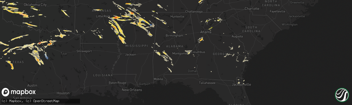
Hail Map in Alabama on June 11, 2023
The weather event in Alabama on June 11, 2023 includes Hail, Wind, and Tornado maps. 23 states and 920 cities were impacted and suffered possible damage. The total estimated number of properties impacted is 263.
Want more than just the map?
Turn this storm into a full workflow.
- Owner + property data so you know who to knock
- OnDemand branded weather history reports to win the "did we even have hail?" argument
- RoofTrace estimate so reps stop guessing numbers at the door
Bought this map? Upgrade within 7 days and we'll credit the $230. (10-15 min setup call)
Hail
Wind
Tornado
263
Estimated number of impacted properties by a 1.00" hail or larger0
Estimated number of impacted properties by a 1.75" hail or larger0
Estimated number of impacted properties by a 2.50" hail or largerStorm reports in Alabama
Alabama
| Date | Description |
|---|---|
| 06/11/20234:45 PM CDT | High winds caused numerous power outages due to tree limbs and other debris blowing into power lines. |
| 06/11/20232:14 PM CDT | A few trees were blown down on us 80 east of tuskegee. |
| 06/11/20234:19 AM CDT | Henry co dispatch reports trees down on hwy 95 between 37 and cr214. |
| 06/11/20234:19 AM CDT | Henry co dispatch reports trees down on 431 between cr 133 and 214. |
| 06/11/20231:39 AM CDT | Trees blown down in and around tuskegee. |
| 06/11/20231:30 AM CDT | Trees blown down in the franklin community. |
| 06/11/20231:18 AM CDT | Multiple trees down at hwy 66 and cr 109 near central mills via social media. |
| 06/10/202311:40 PM CDT | Tree down reports in various locations across shelby county. |
| 06/10/202311:20 PM CDT | Tree on house on riverchase pkwy. |
| 06/10/202311:12 PM CDT | Reports of trees down near shades crest road. |
| 06/10/202311:12 PM CDT | Numerous reports of trees down in the hoover/vestavia hills area. |
| 06/10/202310:35 PM CDT | Trees down around springville. |
| 06/10/20239:38 PM CDT | Tree down on highway 129 near hubbertville high school. Another tree down on highway 102. |
| 06/10/20239:28 PM CDT | Roof damage and power lines down in winfield. |
| 06/10/20239:26 PM CDT | Power lines down along beaver creek road and trees down near vernon. |
| 06/10/20239:14 PM CDT | Large tree branch down blocking part of the road. |
| 06/10/20239:11 PM CDT | Tree down blocking wall rd near hwy 72e. Time estimated by radar. |
| 06/10/20239:02 PM CDT | Power lines down on county road 43. |
| 06/10/20239:00 PM CDT | Power line down at university and pulaski pike. |
| 06/10/20239:00 PM CDT | Tree down near montdale rd and big cove dr. |
| 06/10/20239:00 PM CDT | Power line down near oakwood and minor. |
| 06/10/20239:00 PM CDT | Tree down on house at intersection of russel and rison. |
| 06/10/20239:00 PM CDT | Tree down along shady ln dr. Time estimated based on radar. |
| 06/10/20239:00 PM CDT | Power line down along lowe ave. |
| 06/10/20239:00 PM CDT | Power line down along st. Clair ave. |
| 06/10/20239:00 PM CDT | Trees down in sw marion county. Tree across road in vicinity of highway 19. Power outages reported in area. |
| 06/10/20239:00 PM CDT | Tree down on back patio at whnt. |
| 06/10/20239:00 PM CDT | Tree snapped in half along dug hill road. Photo via social media. |
All States Impacted by Hail Map on June 11, 2023
Cities Impacted by Hail Map on June 11, 2023
- Axtell, NE
- Minden, NE
- Chanute, KS
- Erie, KS
- Galesburg, KS
- Sandersville, GA
- Columbia, SC
- Elgin, SC
- Lugoff, SC
- Quinton, OK
- Red Oak, OK
- Kinta, OK
- Wilburton, OK
- Walsenburg, CO
- Hardaway, AL
- Tuskegee, AL
- Lebanon, TN
- Watertown, TN
- Brush Creek, TN
- Alexandria, TN
- Liberty, KY
- Elk Horn, KY
- Aguilar, CO
- Talihina, OK
- Wister, OK
- Charlotte, TN
- White Bluff, TN
- Ashland City, TN
- Albany, KY
- Baxter, TN
- Bloomington Springs, TN
- Gainesboro, TN
- Cookeville, TN
- Trinidad, CO
- Hustonville, KY
- Middleburg, KY
- Byrdstown, TN
- Monroe, TN
- Pall Mall, TN
- Monticello, KY
- Livingston, TN
- Rickman, TN
- Allred, TN
- Crawford, TN
- Alpine, TN
- Nancy, KY
- Somerset, KY
- Russell Springs, KY
- Ferguson, KY
- Windsor, KY
- Dunnville, KY
- Yosemite, KY
- Nashville, TN
- Madison, TN
- Old Hickory, TN
- Hendersonville, TN
- Jamestown, TN
- Wilder, TN
- Model, CO
- Littleton, CO
- Lone Tree, CO
- Sedalia, CO
- Grantville, GA
- Moreland, GA
- Luthersville, GA
- Castle Rock, CO
- Parker, CO
- Franktown, CO
- Allardt, TN
- Branson, CO
- Trinchera, CO
- Stuttgart, AR
- Hazen, AR
- De Valls Bluff, AR
- Roe, AR
- Sharpsburg, GA
- Newnan, GA
- Senoia, GA
- Clarendon, AR
- Altheimer, AR
- Wabbaseka, AR
- Elizabeth, CO
- Holly Grove, AR
- Crossville, TN
- Crab Orchard, TN
- Rockwood, TN
- Proctor, AR
- Helenwood, TN
- Huntsville, TN
- Wynne, AR
- Walls, MS
- Abilene, TX
- Buffalo Gap, TX
- Tuscola, TX
- Pioneer, TN
- Oneida, TN
- Horn Lake, MS
- Byhalia, MS
- Red Banks, MS
- Trumann, AR
- Marked Tree, AR
- Oakdale, TN
- Wartburg, TN
- Tyronza, AR
- Lepanto, AR
- Brinkley, AR
- Aubrey, AR
- Oliver Springs, TN
- Harriman, TN
- Newcomb, TN
- Morrilton, AR
- La Follette, TN
- Plumerville, AR
- Kim, CO
- Dryden, TX
- Southaven, MS
- Clyde, TX
- Joiner, AR
- Dyess, AR
- Albany, TX
- Greenbrier, AR
- Conway, AR
- Gouldbusk, TX
- Coleman, TX
- Santa Anna, TX
- Lake Cormorant, MS
- Weatherford, TX
- Nesbit, MS
- Tipp City, OH
- De Witt, AR
- Gillett, AR
- Kings Mountain, KY
- Waynesburg, KY
- Statesboro, GA
- Metter, GA
- Register, GA
- Springfield, TN
- White House, TN
- Cherry Valley, AR
- Hickory Ridge, AR
- Stanton, TN
- Hogansville, GA
- Lagrange, GA
- Carthage, TN
- Louviers, CO
- Flippin, AR
- Lake George, CO
- Lyons, GA
- Swainsboro, GA
- Midville, GA
- Crane, MO
- Marionville, MO
- Billings, MO
- Dixon Springs, TN
- Riddleton, TN
- Hartsville, TN
- Fort Stockton, TX
- Greensburg, KY
- Campbellsville, KY
- Pleasant Shade, TN
- Guyton, GA
- Rocky Ford, GA
- Millen, GA
- Sylvania, GA
- Crab Orchard, KY
- Newport, AR
- Bradford, AR
- Hestand, KY
- Tompkinsville, KY
- Sparta, TN
- Humphrey, AR
- Marion, AR
- Ovalo, TX
- Jamestown, KY
- Garnett, SC
- Pineland, SC
- Moss, TN
- Whitleyville, TN
- Celina, TN
- Gay, GA
- Callahan, FL
- Beedeville, AR
- McCrory, AR
- Castalian Springs, TN
- Bethpage, TN
- Memphis, TN
- Olive Branch, MS
- Bloomingdale, GA
- Mount Juliet, TN
- Gallatin, TN
- Brigham City, UT
- Englewood, CO
- Dickson, TN
- Robbins, TN
- Headland, AL
- Brodhead, KY
- Hardyville, KY
- Knifley, KY
- Columbia, KY
- Dardanelle, AR
- Woodbury, TN
- Monterey, TN
- Milton, TN
- Lascassas, TN
- Allons, TN
- Valera, TX
- Hilham, TN
- Red Boiling Springs, TN
- Lafayette, TN
- Burkesville, KY
- Heth, AR
- Midway, GA
- Hilliard, FL
- Edmonton, KY
- Portland, TN
- Spring City, TN
- Mccurtain, OK
- Whitesboro, OK
- Notasulga, AL
- Auburn, AL
- Hermitage, TN
- Pegram, TN
- Norton, TX
- Mount Vernon, KY
- Cobbtown, GA
- Buffalo Valley, TN
- Ulm, AR
- Carlisle, AR
- Crawfordsville, AR
- Estill, SC
- Tillman, SC
- Parkin, AR
- Hickman, TN
- Gordonsville, TN
- Hobe Sound, FL
- Mason, TN
- Grenville, NM
- Folsom, NM
- Gould, AR
- Sunbright, TN
- Watson, AR
- Tichnor, AR
- Evensville, TN
- Hernando, MS
- Lenoir City, TN
- Knoxville, TN
- Farragut, TN
- Rochelle, TX
- Clinton, TN
- Briceville, TN
- Michie, TN
- Counce, TN
- Coldwater, MS
- Boise, ID
- Courtland, MS
- Batesville, MS
- Fort Worth, TX
- Azle, TX
- Oxford, MS
- Rohwer, AR
- Benoit, MS
- Merkel, TX
- Hawley, TX
- Almyra, AR
- Hereford, TX
- Adrian, TX
- Taylor, MS
- Potts Camp, MS
- Myrtle, MS
- Water Valley, MS
- Marianna, AR
- Rockwall, TX
- Royse City, TX
- Tunica, MS
- New Albany, MS
- Pontotoc, MS
- Roanoke, TX
- Ecru, MS
- Blue Springs, MS
- Southlake, TX
- Flower Mound, TX
- Anson, TX
- Lueders, TX
- Boise City, OK
- Kenton, OK
- Thaxton, MS
- Randolph, MS
- Moran, TX
- Breckenridge, TX
- Ethel, AR
- Snow Lake, AR
- Gunnison, MS
- Belden, MS
- Cisco, TX
- Lohn, TX
- Naval Air Station Jrb, TX
- Tupelo, MS
- Argyle, TX
- Lewisville, TX
- Toccoa, GA
- Eastanollee, GA
- Cranks, KY
- Pennington Gap, VA
- Rosedale, MS
- Merigold, MS
- Mound Bayou, MS
- Vega, TX
- Wildorado, TX
- Dallas, TX
- Canyon, TX
- Happy, TX
- Banner, MS
- Bruce, MS
- Granbury, TX
- Godley, TX
- Cleburne, TX
- Capulin, NM
- Des Moines, NM
- Raton, NM
- Strawn, TX
- Graford, TX
- Palo Pinto, TX
- Lake Dallas, TX
- Beulah, MS
- The Colony, TX
- Carrollton, TX
- Plano, TX
- Jasper, GA
- Marble Hill, GA
- Dawsonville, GA
- Frisco, TX
- Grandview, TX
- Rio Vista, TX
- Mineral Wells, TX
- Allen, TX
- Covington, TX
- Mckinney, TX
- Ennis, TX
- Waxahachie, TX
- Keyes, OK
- Amarillo, TX
- Tulia, TX
- Perrin, TX
- Joshua, TX
- Crowley, TX
- Silverton, TX
- Barry, TX
- Italy, TX
- Blooming Grove, TX
- Corsicana, TX
- Poolville, TX
- Clayton, NM
- Springtown, TX
- Agate, CO
- Limon, CO
- Matheson, CO
- Burleson, TX
- Purdon, TX
- Texhoma, OK
- Goodwell, OK
- Cleveland, MS
- Boyle, MS
- Shaw, MS
- Indianola, MS
- Clarendon, TX
- Quitaque, TX
- Boyd, TX
- Paradise, TX
- Tolar, TX
- Rhome, TX
- Glen Rose, TX
- Moorhead, MS
- Greenville, TX
- Honey Grove, TX
- Ladonia, TX
- Roxton, TX
- Caddo Mills, TX
- Pecan Gap, TX
- Paris, TX
- Pattonville, TX
- Rainbow, TX
- Aquilla, TX
- Abbott, TX
- West, TX
- Deport, TX
- Lake Creek, TX
- Penelope, TX
- Mount Calm, TX
- Sulphur Bluff, TX
- Cooper, TX
- Childress, TX
- Turkey, TX
- Felt, OK
- Clarksville, TX
- Idabel, OK
- Haworth, OK
- Blum, TX
- Kopperl, TX
- Axtell, TX
- Hubbard, TX
- Bogata, TX
- Miami, NM
- Springer, NM
- Greenville, MS
- Leland, MS
- Mart, TX
- Dalhart, TX
- Whitney, TX
- Tell, TX
- Stratford, TX
- Morgan, TX
- Clifton, TX
- Valley Mills, TX
- Aspermont, TX
- Hollandale, MS
- Waco, TX
- China Spring, TX
- Anguilla, MS
- Belzoni, MS
- Louise, MS
- Hampton, AR
- Sarah, MS
- Crenshaw, MS
- Kiowa, CO
- Winfield, TN
- Sparkman, AR
- Camden, AR
- McRae Helena, GA
- Glenwood, GA
- Sledge, MS
- Dacula, GA
- Maxwell, NM
- Covington, TN
- Riverside, OR
- Springfield, GA
- Haleyville, AL
- Phil Campbell, AL
- Waynesboro, TN
- Clifton, TN
- Bath Springs, TN
- Bronston, KY
- Colt, AR
- Howard, CO
- Claxton, GA
- Millsap, TX
- Senatobia, MS
- Como, MS
- Sardis, MS
- Lawrenceville, GA
- Loxahatchee, FL
- Blossom, TX
- Detroit, TX
- Kingston, TN
- Pritchett, CO
- Mesquite, TX
- Princeton, TX
- Milliken, CO
- Ranger, TX
- Rienzi, MS
- Gordon, TX
- Baird, TX
- Caddo, TX
- Jacksonville, FL
- Richmond Hill, GA
- Guffey, CO
- Kingston Springs, TN
- Fairview, TN
- Augusta, AR
- Gurdon, AR
- Rowlett, TX
- Lula, GA
- Alto, GA
- Cornelia, GA
- Coppell, TX
- Washington, AR
- Columbus, AR
- Fulton, AR
- Wylie, TX
- Quinlan, TX
- Nevada, TX
- Rosie, AR
- Oil Trough, AR
- Thida, AR
- Magness, AR
- Fernandina Beach, FL
- Newville, AL
- Abbeville, AL
- Columbia, AL
- Ten Mile, TN
- Dayton, TN
- Ball Ground, GA
- Moro, AR
- Palestine, AR
- Talpa, TX
- Decaturville, TN
- Bairoil, WY
- Simla, CO
- Philadelphia, TN
- Loudon, TN
- Houlka, MS
- Houston, MS
- Fleming, GA
- Cotopaxi, CO
- Dundee, MS
- Holly Springs, MS
- Grapevine, TX
- Russellville, AL
- Helena, AR
- Marvell, AR
- Lexa, AR
- Poplar Grove, AR
- Cordova, TN
- Ramah, CO
- Lawrenceburg, TN
- Summertown, TN
- Ethridge, TN
- Belmont, MS
- Foreman, AR
- Ashdown, AR
- Palmer, TX
- Townville, SC
- Norcross, GA
- Lilburn, GA
- Dahlonega, GA
- Waterford, MS
- Garland, TX
- Baldwin, GA
- Tishomingo, MS
- Cherokee, AL
- Greenville, GA
- Keller, TX
- Cumming, GA
- Jellico, TN
- Duff, TN
- Drummonds, TN
- Rocky Top, TN
- Rockwood, TX
- Paris, ID
- Little Elm, TX
- Chidester, AR
- Twin Falls, ID
- Delta, UT
- Bard, NM
- Munford, TN
- Atoka, TN
- Bagwell, TX
- Red Oak, TX
- Grand Prairie, TX
- Irving, TX
- Mountain View, AR
- Dennis, MS
- Red Bay, AL
- Hickory Flat, MS
- Blue Mountain, MS
- Brighton, TN
- Lancing, TN
- Glennville, GA
- Aurora, CO
- Tarrytown, GA
- Vidalia, GA
- Dumas, AR
- Murrayville, GA
- Cleveland, GA
- Saltillo, MS
- Mantachie, MS
- Mooreville, MS
- Osceola, AR
- Etowah, AR
- Etta, MS
- Abbeville, MS
- Paris, MS
- Rising Star, TX
- Peachtree City, GA
- Sumner, TX
- Arlington, TX
- Mansfield, TX
- Cedar Hill, TX
- Midlothian, TX
- Spruce Pine, AL
- Iuka, MS
- Bearden, AR
- Alamo, GA
- Fairmount, GA
- Rydal, GA
- Cascade, ID
- West Helena, AR
- Oak Ridge, TN
- Melbourne, AR
- Batesville, AR
- Fifty Six, AR
- Pleasant Grove, AR
- Clarkesville, GA
- Demorest, GA
- Tillar, AR
- England, AR
- Lonoke, AR
- Franklin, TN
- Farmersville, TX
- Westpoint, TN
- Niota, TN
- Decatur, TN
- Bluff City, AR
- Prescott, AR
- Powell, TN
- Heiskell, TN
- Earle, AR
- Kingsland, AR
- Sunnyvale, TX
- Bloomington, ID
- Guys, TN
- Winthrop, AR
- Grimsley, TN
- Guntown, MS
- Weston, CO
- Savannah, GA
- Pooler, GA
- Waterloo, AL
- Hinesville, GA
- Mount Airy, GA
- Mount Vernon, GA
- Soperton, GA
- Brickeys, AR
- Robinsonville, MS
- Booneville, MS
- Corinth, MS
- Okolona, MS
- Williamsburg, KY
- Cresson, TX
- Wingate, TX
- Winters, TX
- Bunnell, FL
- Nettleton, MS
- Canon City, CO
- Elmwood, TN
- Auburntown, TN
- Screven, GA
- Sachse, TX
- Lavon, TX
- Grandview, TN
- Boswell, OK
- Vardaman, MS
- Pittsboro, MS
- Lancaster, TX
- Tate, GA
- Marks, MS
- Newark, TX
- Germantown, TN
- Eads, TN
- Collierville, TN
- Bryceville, FL
- Andersonville, TN
- Thornton, AR
- Arthur City, TX
- Plantersville, MS
- Fulton, MS
- Shannon, MS
- Smithville, MS
- Amory, MS
- Corinne, UT
- Frenchmans Bayou, AR
- Bassett, AR
- Williamson, GA
- Brooks, GA
- Haslet, TX
- Widener, AR
- Hughes, AR
- Aledo, TX
- Dowelltown, TN
- Liberty, TN
- Ramer, TN
- Ludowici, GA
- Hugo, OK
- Venus, TX
- Kennedale, TX
- Alvarado, TX
- Old Glory, TX
- Elm Mott, TX
- Gruver, TX
- Texhoma, TX
- Rule, TX
- Stamford, TX
- Arkansas City, AR
- Gladstone, NM
- Inverness, MS
- Isola, MS
- Avoca, TX
- Demopolis, AL
- Sedan, NM
- Throckmorton, TX
- Texline, TX
- Mosquero, NM
- Nara Visa, NM
- Amistad, NM
- Hartley, TX
- Channing, TX
- Logan, NM
- Newcastle, TX
- Olney, TX
- Holliday, TX
- Ocate, NM
- Wagon Mound, NM
- Windthorst, TX
- Grady, AR
- Tellico Plains, TN
- Johnstown, CO
- Snellville, GA
- Grayson, GA
- Juntura, OR
- West Point, MS
- Prairie, MS
- Westminster, SC
- Union Point, GA
- Tuttle, OK
- Blanchard, OK
- Newcastle, OK
- Starkville, MS
- Cedarbluff, MS
- Columbus, MS
- Campbell, TX
- Snyder, TX
- Keiser, AR
- Ben Franklin, TX
- Nemo, TX
- Gardendale, AL
- Pope, MS
- Loretto, TN
- Deatsville, AL
- Marbury, AL
- McGehee, AR
- Martin, GA
- Oxford, AL
- Munford, AL
- Rincon, GA
- Hillsboro, TX
- Double Springs, AL
- Keene, TX
- Twain, CA
- Quincy, CA
- Guion, AR
- Calico Rock, AR
- Mount Pleasant, AR
- Eutaw, AL
- Boligee, AL
- De Kalb, MS
- Scooba, MS
- Pinson, AL
- Birmingham, AL
- Morris, AL
- Warrior, AL
- Mount Olive, AL
- Itasca, TX
- Mora, NM
- Cimarron, NM
- Norfork, AR
- Fair Play, SC
- Macon, MS
- Canton, GA
- Rotan, TX
- York, AL
- Cuba, AL
- Central, SC
- Anderson, SC
- Pendleton, SC
- Liberty, SC
- Clemson, SC
- Faunsdale, AL
- Woodland, MS
- Verbena, AL
- Jayton, TX
- Hugo, CO
- Houston, AL
- Pine Apple, AL
- Porterville, MS
- Casscoe, AR
- Aliceville, AL
- New Market, AL
- Carnesville, GA
- Tuskegee Institute, AL
- Louisville, GA
- Seneca, SC
- Lillian, TX
- Wayside, TX
- Trenton, TX
- Whitewright, TX
- Norman, OK
- Washington, OK
- Noble, OK
- Lexington, OK
- Mustang, OK
- Oklahoma City, OK
- Roy, NM
- Dumas, TX
- Sunray, TX
- Stinnett, TX
- Panhandle, TX
- Fritch, TX
- Masterson, TX
- Skellytown, TX
- Borger, TX
- Pampa, TX
- White Deer, TX
- Groom, TX
- Sayre, OK
- Carter, OK
- Elk City, OK
- Dill City, OK
- Canute, OK
- Hobart, OK
- Gotebo, OK
- Roosevelt, OK
- Mountain View, OK
- Carnegie, OK
- Hammon, OK
- Butler, OK
- Foss, OK
- Paoli, OK
- Pauls Valley, OK
- Stratford, OK
- Apache, OK
- Sentinel, OK
- Cordell, OK
- Clinton, OK
- Mclean, TX
- Lawton, OK
- Elgin, OK
- Shamrock, TX
- Fletcher, OK
- Rush Springs, OK
- Marlow, OK
- Erick, OK
- Temple, OK
- Walters, OK
- Comanche, OK
- Waurika, OK
- Ringling, OK
- Ryan, OK
- Verona, MS
- Science Hill, KY
- Norris, TN
- Maynardville, TN
- Cheyenne, OK
- Rainsville, NM
- Adrian, GA
- Kite, GA
- Wrightsville, GA
- Willow, OK
- Fitzhugh, OK
- Ada, OK
- Henrietta, TX
- Bellevue, TX
- Castleberry, AL
- Brewton, AL
- Fort Sill, OK
- Uniontown, AL
- Thomaston, AL
- Safford, AL
- Catherine, AL
- Purcell, OK
- Lone Wolf, OK
- Granite, OK
- Cyril, OK
- Newbern, AL
- Cement, OK
- Lindsay, OK
- Meigs, GA
- Sale City, GA
- Hartsfield, GA
- Camden, AL
- Fort Cobb, OK
- Pennington, AL
- Sweet Water, AL
- Linden, AL
- Bellamy, AL
- Livingston, AL
- Reydon, OK
- Annona, TX
- Arlington, AL
- Wilson, OK
- Hastings, OK
- Silver City, MS
- Rocky, OK
- Coy, AL
- Pine Hill, AL
- Hurtsboro, AL
- Hatchechubbee, AL
- Tallassee, AL
- Haskell, TX
- Celeste, TX
- Leonard, TX
- Weatherford, OK
- Arapaho, OK
- Denton, TX
- Shorter, AL
- Georgiana, AL
- Evergreen, AL
- McKenzie, AL
- Magnolia, AL
- Alberta, AL
- Byars, OK
- Wheeler, TX
- Minter, AL
- Gallion, AL
- Orrville, AL
- Pittsview, AL
- Sweetwater, OK
- Auburn, GA
- Anadarko, OK
- Miami, TX
- Canadian, TX
- Range, AL
- Lenox, AL
- Repton, AL
- Briscoe, TX
- Monroeville, AL
- Corn, OK
- Lower Peach Tree, AL
- Texola, OK
- Christiansburg, OH
- Saint Paris, OH
- York, PA


