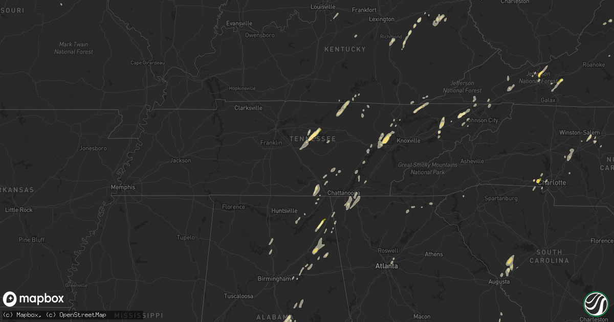
Hail Map in Tennessee on June 10, 2014
Get this storm
June 10 map
$229
one time, instant access
Download today. No call, no setup
Keep the $229
Bought the map and want the full workflow? Apply the entire $229 to a subscription within 7 days. None of it is wasted.
Every map, not just this one
This buys you this map. Subscription and you get every map we run, in the markets you choose from a few cities to whole states to nationwide. Plus real-time alerts the moment a storm fires.
Contact data
Name, contact info, occupancy, even credit band for addresses in the footprint. You go from where it hit to who to call.
Become the source they trust
Unlimited branding weather history reports on demand. You already have the documented answer ready for the property owner, and you are the one who showed up with it.
Property data and RoofTrace estimates
Pull up any address you have got, its value and the exact code rules for that jurisdiction, straight from One Click Code. Then RoofTrace estimates the squares, pitch, and roof value, priced the way you price.
Storm reports in Tennessee
Tennessee
| Date | Description |
|---|---|
| 06/10/20146:45 PM CDT | Several trees down in jonesborough. |
| 06/10/20146:15 PM CDT | Sporadic tree damage across county. |
| 06/10/20146:10 PM CDT | Sporadic tree damage across county |
| 06/10/20146:00 PM CDT | 2 trees down on powerlines in south part of county |
| 06/10/20145:40 PM CDT | Quarter size hail reported al slop creek road |
| 06/10/20145:40 PM CDT | Trees down countywide |
| 06/10/20145:40 PM CDT | Trees down countywide |
| 06/10/20145:30 PM CDT | Trees down countywide |
| 06/10/20145:30 PM CDT | Large tree fell on house... Couple of other trees down on propery |
| 06/10/20145:30 PM CDT | Trees down countywide |
| 06/10/20145:30 PM CDT | Trees and powerlines down countywide... Small hail reported western part of county |
| 06/10/20145:20 PM CDT | Trees down countywide |
| 06/10/20145:15 PM CDT | Trees down countywide |
| 06/10/20145:00 PM CDT | Trees down countywide |
| 06/10/20144:40 PM CDT | Trees down countywide |
| 06/10/20144:30 PM CDT | Multiple trees and popwerlines down around oliver springs... Spotter measured wind gust 70+ |
| 06/10/20144:15 PM CDT | 2 trees down over western part of county |
| 06/10/20144:15 PM CDT | Trees and powerlines down countywide |
| 06/10/20144:06 PM CDT | A small efo tornado formed just east of downtown kingston...and moved to the northeast along a hillside producing a distinct path with hundreds of downed trees. Path le |
| 06/10/20144:05 PM CDT | Trees down across the city park |
| 06/10/20144:05 PM CDT | Trees down countywide... Report of trees across roads and one tree down on car-no one was in car |
| 06/10/20143:57 PM CDT | Multiple trees down |
| 06/10/20143:50 PM CDT | Roof blown off barn and roof damage to home due to fallen tree |
| 06/10/20143:41 PM CDT | Multiple trees and power lines down across fentress county via emergency manager |
| 06/10/20143:40 PM CDT | Trees and powerlines down county |
| 06/10/20143:27 PM CDT | Multiple trees and powerlines down |
| 06/10/20143:27 PM CDT | Tree down across i-40. |
| 06/10/20143:23 PM CDT | Structural damage to the royal oaks office building. |
| 06/10/20143:17 PM CDT | Tree down blocking the crossville highway at the 8800 block. |
| 06/10/20143:15 PM CDT | Tree down on west loop rd in the eastland community. |
| 06/10/20143:11 PM CDT | Multiple trees down at je bartlett road and hwy 70 |
| 06/10/20143:06 PM CDT | Multiple trees down |
| 06/10/20143:05 PM CDT | Widespread trees and power lines down. Some trees over homes and cars. |
| 06/10/20142:56 PM CDT | Several trees and powerlines down around the city |
| 06/10/20142:54 PM CDT | Tree down along fanchers mill rd. |
| 06/10/20142:50 PM CDT | Trees down. |
| 06/10/20142:50 PM CDT | Trees and power lines down across the county. Some on top of homes. |
| 06/10/20142:45 PM CDT | Multiple trees and power lines down south of moss on midway road. |
| 06/10/20142:44 PM CDT | Multiple trees down around town. 60th ave. 40th ave. Hwy 108. Hwy 399. |
| 06/10/20142:30 PM CDT | Trees down countywide and dime size hail |
| 06/10/20142:30 PM CDT | Trees and power lines down across the county. Some reported on homes. |
| 06/10/20142:30 PM CDT | Tree down at courthouse square in jasper... Marion co |
| 06/10/20142:25 PM CDT | Quarter size hail reported in byrdstown |
| 06/10/20142:10 PM CDT | Power lines reportedly blown down in southeast smith county with power outages |
| 06/10/20141:45 PM CDT | Tspotter report of trees and tree limbs blown down in the hilham area |
| 06/10/20141:18 PM CDT | Several trees and power lines and a power pole were downed along with two outbuildings heavily damaged by thunderstorm winds. |
| 06/10/20141:00 PM CDT | Tspotter report of quarter size hail on i-40 near the smith and wilson county line |
| 06/10/201412:35 PM CDT | A local report indicates 1.75 inch wind near LIBERTY |
| 06/10/201412:32 PM CDT | Multiple trees downed |
All States Impacted by Hail Map on June 10, 2014
Cities Impacted by Hail Map on June 10, 2014
- Pamplin, VA
- Prospect, VA
- Reed Point, MT
- Gadsden, AL
- Centre, AL
- Leesburg, AL
- Collinsville, AL
- Liberty, TN
- Lakeland, FL
- Belle Fourche, SD
- Nisland, SD
- Mooresburg, TN
- Whitesburg, TN
- Fort Payne, AL
- Moore, MT
- Nahunta, GA
- Tallassee, AL
- Leesburg, FL
- Sanderson, FL
- White Pine, TN
- Rock Spring, GA
- Ringgold, GA
- Morristown, TN
- Russellville, TN
- Sequatchie, TN
- Tracy City, TN
- Metter, GA
- Preston, GA
- Jesup, GA
- Hortense, GA
- Inverness, FL
- Monroe, VA
- Forest, VA
- Big Island, VA
- Lynchburg, VA
- Madison Heights, VA
- Coleman Falls, VA
- Morgan, GA
- Kaycee, WY
- Harrison, NE
- Edgemont, SD
- Dahlonega, GA
- Cleveland, GA
- Minter, AL
- Beatrice, AL
- Tyler, AL
- Pine Apple, AL
- Sardis, AL
- Oliver Springs, TN
- Wartburg, TN
- Vesuvius, VA
- Roseland, VA
- Amherst, VA
- Bland, VA
- Fort McCoy, FL
- Oak Ridge, TN
- Kingston, TN
- Briceville, TN
- Harriman, TN
- Clinton, TN
- Verbena, AL
- Clanton, AL
- Stanton, KY
- Means, KY
- Jeffersonville, KY
- Frenchburg, KY
- Cumberland Gap, TN
- Surrency, GA
- Odum, GA
- Glennville, GA
- Clover, SC
- Berea, KY
- Richmond, KY
- Greeneville, TN
- Rogersville, TN
- Rainsville, AL
- Sylvania, AL
- Geneva, FL
- Sherwood, TN
- Sewanee, TN
- Prattville, AL
- Billingsley, AL
- Marbury, AL
- Wytheville, VA
- Loxahatchee, FL
- East Dublin, GA
- Rockledge, GA
- Clay City, KY
- Polk City, FL
- Groveland, FL
- Sylacauga, AL
- Trenton, SC
- Aiken, SC
- Salt Lick, KY
- Morehead, KY
- Dunlap, TN
- Mulberry, FL
- Lumberton, MS
- Bulls Gap, TN
- Camden, AL
- Lexington, NC
- Winston Salem, NC
- Greenville, AL
- McKenzie, AL
- Georgiana, AL
- Caryville, TN
- Lowell, NC
- Gastonia, NC
- Alachua, FL
- Brooker, FL
- Appomattox, VA
- Junction City, GA
- Talbotton, GA
- Lithia, FL
- Newport, TN
- Dandridge, TN
- West Liberty, KY
- Limestone, TN
- Monroe, TN
- Byrdstown, TN
- Albany, KY
- Livingston, TN
- Hilham, TN
- Allons, TN
- Concord, NC
- Mount Pleasant, NC
- Colfax, NC
- High Point, NC
- Thomasville, NC
- Kernersville, NC
- Dayton, TN
- Evensville, TN
- Glade Spring, VA
- Marion, VA
- Saltville, VA
- Jamestown, NC
- Hiwassee, VA
- Auburntown, TN
- Hickman, TN
- Woodbury, TN
- Alexandria, TN
- Lancaster, TN
- Dowelltown, TN
- Kingsport, TN
- Palmer, TN
- Gillette, WY
- Blairsville, GA
- Montgomery, AL
- Ceres, VA
- Umatilla, FL
- Eustis, FL
- Gladstone, VA
- Grandview, TN
- Spring City, TN
- Deland, FL
- Ragland, AL
- Lincoln, AL
- Riverside, AL
- Pell City, AL
- Johnston, SC
- Olympia, KY
- Omaha, GA
- Lumpkin, GA
- Hoboken, GA
- Howey In The Hills, FL
- Sorrento, FL
- Mount Dora, FL
- Saint Cloud, FL
- Taylorsville, KY
- Mount Washington, KY
- Louisville, KY
- Dade City, FL
- Sale Creek, TN
- Bedford, VA
- Georgetown, GA
- Millboro, VA
- Pearl, IL
- Stevenson, AL
- South Pittsburg, TN
- Bridgeport, AL
- Cullman, AL
- Vinemont, AL
- Gaylesville, AL
- Sturgis, SD
- New Underwood, SD
- Irvine, KY
- Claxton, GA
- Rising Fawn, GA
- Menlo, GA
- Mentone, AL
- Weogufka, AL
- Goodwater, AL
- Raiford, FL
- Ridge Spring, SC
- Farmville, VA
- La Fayette, GA
- Sandy Hook, KY
- Greensboro, NC
- Auburndale, FL
- Wentzville, MO
- O'Fallon, MO
- Clermont, FL
- Ward, SC
- Robertsdale, AL
- Fort Gaines, GA
- Lewistown, MT
- Stanley, NC
- Mount Holly, NC
- Apopka, FL
- Shorter, AL
- Hardaway, AL
- Waycross, GA
- Hermann, MO
- Titus, AL
- Bowling Green, FL
- Piedmont, AL
- Jacksonville, AL
- Forest Home, AL
- Millbrook, AL
- Lowndesboro, AL
- Dawson, GA
- Fitzpatrick, AL
- Portal, GA
- Statesboro, GA
- Hillsville, VA
- Max Meadows, VA
- Austinville, VA
- Fellsmere, FL
- Bristol, TN
- Troy, AL
- Bristol, VA
- Kissimmee, FL
- Davenport, FL
- Greybull, WY
- Lovell, WY
- Booth, AL
- Rockwood, TN
- Tucker, GA
- Atlanta, GA
- Chatham, VA
- Burlington, NC
- Red Level, AL
- Dozier, AL
- Orange Park, FL
- Middleburg, FL
- Green Cove Springs, FL
- Harrogate, TN
- Saint George, GA
- Folkston, GA
- Rocky Top, TN
- Randleman, NC
- Linwood, NC
- Clearmont, WY
- Arvada, WY
- Jamestown, TN
- Crescent City, FL
- Leary, GA
- Pickens, SC
- Jacksonville, FL
- Cropwell, AL
- Wetumpka, AL
- Chuckey, TN
- Afton, TN
- McKee, KY
- Weston, WY
- Newell, SD
- Interlachen, FL
- Readyville, TN
- Milton, TN
- Elmwood, TN
- Buffalo Valley, TN
- Silver Point, TN
- Lawtey, FL
- Starke, FL
- Dawson, AL
- Wellington, AL
- Punta Gorda, FL
- Walling, TN
- Sparta, TN
- Honoraville, AL
- Rutledge, AL
- Elmore, AL
- Salisbury, NC
- Spencer, NC
- Decatur, GA
- Scottdale, GA
- Clarkston, GA
- Selma, AL
- Miracle, KY
- Blackshear, GA
- Autaugaville, AL
- Palatka, FL
- Manville, WY
- Nickelsville, VA
- Gate City, VA
- Bastian, VA
- Charlotte, NC
- Hilliard, FL
- Pelham, GA
- Cleveland, TN
- Eaton Park, FL
- Ooltewah, TN
- Apison, TN
- Cedar Bluff, VA
- Pounding Mill, VA
- Harrisburg, NE
- Chilhowie, VA
- Meadowview, VA
- Coalmont, TN
- Immokalee, FL
- Labelle, FL
- Zolfo Springs, FL
- Arcadia, FL
- Batesburg, SC
- Bush, LA
- Bogalusa, LA
- Speedwell, TN
- Tazewell, TN
- New Tazewell, TN
- Winter Haven, FL
- Alpha, KY
- Monticello, KY
- Goode, VA
- Hanceville, AL
- Hernando, FL
- Bartow, FL
- Cohutta, GA
- Tunnel Hill, GA
- Rocky Face, GA
- Warrenton, MO
- Berger, MO
- Watertown, TN
- Brush Creek, TN
- Ocala, FL
- Port Saint Lucie, FL
- Pierson, FL
- Seville, FL
- Dunnellon, FL
- Cairo, GA
- Indiantown, FL
- Rentz, GA
- Dublin, GA
- Corolla, NC
- Deatsville, AL
- East Palatka, FL
- Draper, VA
- Scottsboro, AL
- Ewing, VA
- Woodville, AL
- Mackville, KY
- Harrodsburg, KY
- Springfield, KY
- Poplarville, MS
- Graniteville, SC
- North Augusta, SC
- Wrightsville, GA
- Spout Spring, VA
- Concord, VA
- Anniston, AL
- Ohatchee, AL
- Millen, GA
- La Follette, TN
- Jacksboro, TN
- Arlington, GA
- Eclectic, AL
- Paint Lick, KY
- Richland, GA
- Cuba, MO
- Rosebud, MO
- Georgetown, TN
- Birchwood, TN
- Pall Mall, TN
- Haines City, FL
- Pike Road, AL
- Tuskegee, AL
- Cecil, AL
- Ravenna, KY
- Chickamauga, GA
- Middlesboro, KY
- Faith, SD
- Hill City, SD
- Glenwood, AL
- Elba, AL
- Church Hill, TN
- Burkesville, KY
- Patterson, GA
- Webster, FL
- Center Hill, FL
- Clayton, GA
- Tiger, GA
- Clarkesville, GA
- New Hope, AL
- Grant, AL
- Ezel, KY
- Reidsville, GA
- Sylvester, GA
- Ashburn, GA
- Warwick, GA
- Tavares, FL
- Rockford, AL
- Wood, SD
- Valley Head, AL
- Big Timber, MT
- Rapelje, MT


