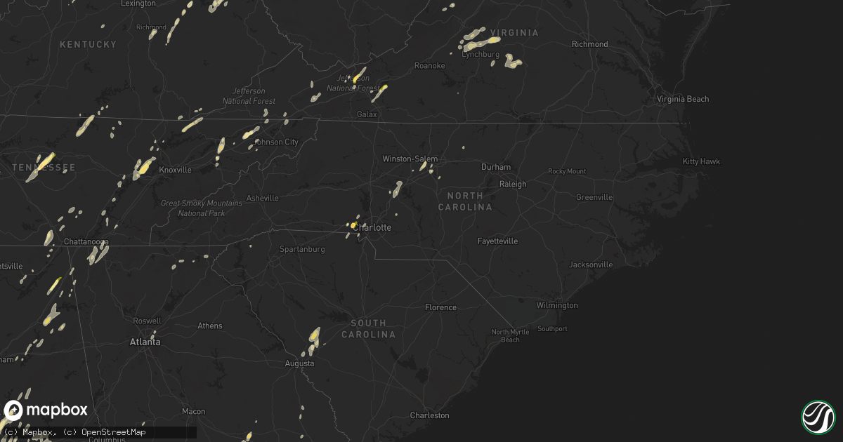
Hail Map in North Carolina on June 10, 2014
Get this storm
June 10 map
$229
one time, instant access
Download today. No call, no setup
Keep the $229
Bought the map and want the full workflow? Apply the entire $229 to a subscription within 7 days. None of it is wasted.
Every map, not just this one
This buys you this map. Subscription and you get every map we run, in the markets you choose from a few cities to whole states to nationwide. Plus real-time alerts the moment a storm fires.
Contact data
Name, contact info, occupancy, even credit band for addresses in the footprint. You go from where it hit to who to call.
Become the source they trust
Unlimited branding weather history reports on demand. You already have the documented answer ready for the property owner, and you are the one who showed up with it.
Property data and RoofTrace estimates
Pull up any address you have got, its value and the exact code rules for that jurisdiction, straight from One Click Code. Then RoofTrace estimates the squares, pitch, and roof value, priced the way you price.
Storm reports in North Carolina
North Carolina
| Date | Description |
|---|---|
| 06/10/20146:45 PM CDT | Quarter size hail in mt. Pleasant |
| 06/10/20146:40 PM CDT | Nickel to quarter sized hail at mt. Pleasant elementary school |
| 06/10/20145:50 PM CDT | Numerous trees down and some powerlines down in the brush creek area west of bryson city. |
| 06/10/20145:45 PM CDT | 2 trees down in concord |
| 06/10/20145:45 PM CDT | Multiple trees and large limbs down on oak leaf cir in twin oaks subdivision |
| 06/10/20145:29 PM CDT | One tree blocking intersection of tallulah rd and jutts creek rd. |
| 06/10/20145:26 PM CDT | Multiple trees down just north of the nantahala community. |
| 06/10/20145:00 PM CDT | Several trees down in murphy |
| 06/10/20144:50 PM CDT | 1.5 inch hail reported east of gastonia. |
| 06/09/201411:20 PM CDT | Tree down near highway 29 and business 29 interchange. |
| 06/09/201411:10 PM CDT | 2 trees down along north 7th street. 1 near roach street and 1 near west jackson. |
| 06/09/201410:48 PM CDT | Several trees and power-lines blown down across the county. |
| 06/09/201410:43 PM CDT | Reported by a spotter on groomtown road. |
| 06/09/201410:38 PM CDT | Tree down on caudill road. |
| 06/09/201410:36 PM CDT | Tree down on sunset drive |
| 06/09/201410:00 PM CDT | Mulitple large limbs down in yard |
| 06/09/201410:00 PM CDT | 6 trees down and 4 power lines down just east of lenoir |
| 06/09/20149:50 PM CDT | One tree was reported down near i-40 east and south main street. |
| 06/09/20149:50 PM CDT | Two trees were reported down between korner rock road and rolling road... Near kernersville road. |
| 06/09/20149:42 PM CDT | Tree down on house just off us hwy 70 between morganton and drexel... Nc. |
| 06/09/20149:38 PM CDT | Numerous trees blown down ne of morganton... Nc. |
| 06/09/20149:32 PM CDT | Tree down on house at north anderson st and collet st. |
| 06/09/20149:30 PM CDT | Trees down off bethel rd in morganton. |
| 06/09/20149:15 PM CDT | Tree fell on house on cannon farm rd. No injuries. Time estimated from radar. |
All States Impacted by Hail Map on June 10, 2014
Cities Impacted by Hail Map on June 10, 2014
- Pamplin, VA
- Prospect, VA
- Reed Point, MT
- Gadsden, AL
- Centre, AL
- Leesburg, AL
- Collinsville, AL
- Liberty, TN
- Lakeland, FL
- Belle Fourche, SD
- Nisland, SD
- Mooresburg, TN
- Whitesburg, TN
- Fort Payne, AL
- Moore, MT
- Nahunta, GA
- Tallassee, AL
- Leesburg, FL
- Sanderson, FL
- White Pine, TN
- Rock Spring, GA
- Ringgold, GA
- Morristown, TN
- Russellville, TN
- Sequatchie, TN
- Tracy City, TN
- Metter, GA
- Preston, GA
- Jesup, GA
- Hortense, GA
- Inverness, FL
- Monroe, VA
- Forest, VA
- Big Island, VA
- Lynchburg, VA
- Madison Heights, VA
- Coleman Falls, VA
- Morgan, GA
- Kaycee, WY
- Harrison, NE
- Edgemont, SD
- Dahlonega, GA
- Cleveland, GA
- Minter, AL
- Beatrice, AL
- Tyler, AL
- Pine Apple, AL
- Sardis, AL
- Oliver Springs, TN
- Wartburg, TN
- Vesuvius, VA
- Roseland, VA
- Amherst, VA
- Bland, VA
- Fort McCoy, FL
- Oak Ridge, TN
- Kingston, TN
- Briceville, TN
- Harriman, TN
- Clinton, TN
- Verbena, AL
- Clanton, AL
- Stanton, KY
- Means, KY
- Jeffersonville, KY
- Frenchburg, KY
- Cumberland Gap, TN
- Surrency, GA
- Odum, GA
- Glennville, GA
- Clover, SC
- Berea, KY
- Richmond, KY
- Greeneville, TN
- Rogersville, TN
- Rainsville, AL
- Sylvania, AL
- Geneva, FL
- Sherwood, TN
- Sewanee, TN
- Prattville, AL
- Billingsley, AL
- Marbury, AL
- Wytheville, VA
- Loxahatchee, FL
- East Dublin, GA
- Rockledge, GA
- Clay City, KY
- Polk City, FL
- Groveland, FL
- Sylacauga, AL
- Trenton, SC
- Aiken, SC
- Salt Lick, KY
- Morehead, KY
- Dunlap, TN
- Mulberry, FL
- Lumberton, MS
- Bulls Gap, TN
- Camden, AL
- Lexington, NC
- Winston Salem, NC
- Greenville, AL
- McKenzie, AL
- Georgiana, AL
- Caryville, TN
- Lowell, NC
- Gastonia, NC
- Alachua, FL
- Brooker, FL
- Appomattox, VA
- Junction City, GA
- Talbotton, GA
- Lithia, FL
- Newport, TN
- Dandridge, TN
- West Liberty, KY
- Limestone, TN
- Monroe, TN
- Byrdstown, TN
- Albany, KY
- Livingston, TN
- Hilham, TN
- Allons, TN
- Concord, NC
- Mount Pleasant, NC
- Colfax, NC
- High Point, NC
- Thomasville, NC
- Kernersville, NC
- Dayton, TN
- Evensville, TN
- Glade Spring, VA
- Marion, VA
- Saltville, VA
- Jamestown, NC
- Hiwassee, VA
- Auburntown, TN
- Hickman, TN
- Woodbury, TN
- Alexandria, TN
- Lancaster, TN
- Dowelltown, TN
- Kingsport, TN
- Palmer, TN
- Gillette, WY
- Blairsville, GA
- Montgomery, AL
- Ceres, VA
- Umatilla, FL
- Eustis, FL
- Gladstone, VA
- Grandview, TN
- Spring City, TN
- Deland, FL
- Ragland, AL
- Lincoln, AL
- Riverside, AL
- Pell City, AL
- Johnston, SC
- Olympia, KY
- Omaha, GA
- Lumpkin, GA
- Hoboken, GA
- Howey In The Hills, FL
- Sorrento, FL
- Mount Dora, FL
- Saint Cloud, FL
- Taylorsville, KY
- Mount Washington, KY
- Louisville, KY
- Dade City, FL
- Sale Creek, TN
- Bedford, VA
- Georgetown, GA
- Millboro, VA
- Pearl, IL
- Stevenson, AL
- South Pittsburg, TN
- Bridgeport, AL
- Cullman, AL
- Vinemont, AL
- Gaylesville, AL
- Sturgis, SD
- New Underwood, SD
- Irvine, KY
- Claxton, GA
- Rising Fawn, GA
- Menlo, GA
- Mentone, AL
- Weogufka, AL
- Goodwater, AL
- Raiford, FL
- Ridge Spring, SC
- Farmville, VA
- La Fayette, GA
- Sandy Hook, KY
- Greensboro, NC
- Auburndale, FL
- Wentzville, MO
- O'Fallon, MO
- Clermont, FL
- Ward, SC
- Robertsdale, AL
- Fort Gaines, GA
- Lewistown, MT
- Stanley, NC
- Mount Holly, NC
- Apopka, FL
- Shorter, AL
- Hardaway, AL
- Waycross, GA
- Hermann, MO
- Titus, AL
- Bowling Green, FL
- Piedmont, AL
- Jacksonville, AL
- Forest Home, AL
- Millbrook, AL
- Lowndesboro, AL
- Dawson, GA
- Fitzpatrick, AL
- Portal, GA
- Statesboro, GA
- Hillsville, VA
- Max Meadows, VA
- Austinville, VA
- Fellsmere, FL
- Bristol, TN
- Troy, AL
- Bristol, VA
- Kissimmee, FL
- Davenport, FL
- Greybull, WY
- Lovell, WY
- Booth, AL
- Rockwood, TN
- Tucker, GA
- Atlanta, GA
- Chatham, VA
- Burlington, NC
- Red Level, AL
- Dozier, AL
- Orange Park, FL
- Middleburg, FL
- Green Cove Springs, FL
- Harrogate, TN
- Saint George, GA
- Folkston, GA
- Rocky Top, TN
- Randleman, NC
- Linwood, NC
- Clearmont, WY
- Arvada, WY
- Jamestown, TN
- Crescent City, FL
- Leary, GA
- Pickens, SC
- Jacksonville, FL
- Cropwell, AL
- Wetumpka, AL
- Chuckey, TN
- Afton, TN
- McKee, KY
- Weston, WY
- Newell, SD
- Interlachen, FL
- Readyville, TN
- Milton, TN
- Elmwood, TN
- Buffalo Valley, TN
- Silver Point, TN
- Lawtey, FL
- Starke, FL
- Dawson, AL
- Wellington, AL
- Punta Gorda, FL
- Walling, TN
- Sparta, TN
- Honoraville, AL
- Rutledge, AL
- Elmore, AL
- Salisbury, NC
- Spencer, NC
- Decatur, GA
- Scottdale, GA
- Clarkston, GA
- Selma, AL
- Miracle, KY
- Blackshear, GA
- Autaugaville, AL
- Palatka, FL
- Manville, WY
- Nickelsville, VA
- Gate City, VA
- Bastian, VA
- Charlotte, NC
- Hilliard, FL
- Pelham, GA
- Cleveland, TN
- Eaton Park, FL
- Ooltewah, TN
- Apison, TN
- Cedar Bluff, VA
- Pounding Mill, VA
- Harrisburg, NE
- Chilhowie, VA
- Meadowview, VA
- Coalmont, TN
- Immokalee, FL
- Labelle, FL
- Zolfo Springs, FL
- Arcadia, FL
- Batesburg, SC
- Bush, LA
- Bogalusa, LA
- Speedwell, TN
- Tazewell, TN
- New Tazewell, TN
- Winter Haven, FL
- Alpha, KY
- Monticello, KY
- Goode, VA
- Hanceville, AL
- Hernando, FL
- Bartow, FL
- Cohutta, GA
- Tunnel Hill, GA
- Rocky Face, GA
- Warrenton, MO
- Berger, MO
- Watertown, TN
- Brush Creek, TN
- Ocala, FL
- Port Saint Lucie, FL
- Pierson, FL
- Seville, FL
- Dunnellon, FL
- Cairo, GA
- Indiantown, FL
- Rentz, GA
- Dublin, GA
- Corolla, NC
- Deatsville, AL
- East Palatka, FL
- Draper, VA
- Scottsboro, AL
- Ewing, VA
- Woodville, AL
- Mackville, KY
- Harrodsburg, KY
- Springfield, KY
- Poplarville, MS
- Graniteville, SC
- North Augusta, SC
- Wrightsville, GA
- Spout Spring, VA
- Concord, VA
- Anniston, AL
- Ohatchee, AL
- Millen, GA
- La Follette, TN
- Jacksboro, TN
- Arlington, GA
- Eclectic, AL
- Paint Lick, KY
- Richland, GA
- Cuba, MO
- Rosebud, MO
- Georgetown, TN
- Birchwood, TN
- Pall Mall, TN
- Haines City, FL
- Pike Road, AL
- Tuskegee, AL
- Cecil, AL
- Ravenna, KY
- Chickamauga, GA
- Middlesboro, KY
- Faith, SD
- Hill City, SD
- Glenwood, AL
- Elba, AL
- Church Hill, TN
- Burkesville, KY
- Patterson, GA
- Webster, FL
- Center Hill, FL
- Clayton, GA
- Tiger, GA
- Clarkesville, GA
- New Hope, AL
- Grant, AL
- Ezel, KY
- Reidsville, GA
- Sylvester, GA
- Ashburn, GA
- Warwick, GA
- Tavares, FL
- Rockford, AL
- Wood, SD
- Valley Head, AL
- Big Timber, MT
- Rapelje, MT


