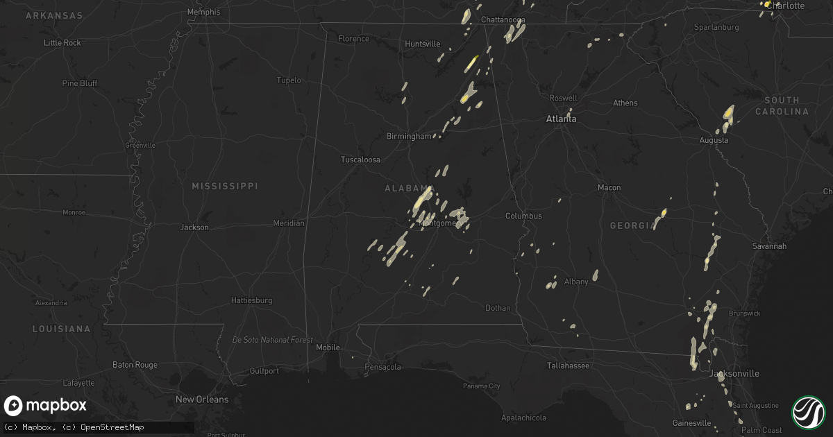
Hail Map in Alabama on June 10, 2014
Get this storm
June 10 map
$229
one time, instant access
Download today. No call, no setup
Keep the $229
Bought the map and want the full workflow? Apply the entire $229 to a subscription within 7 days. None of it is wasted.
Every map, not just this one
This buys you this map. Subscription and you get every map we run, in the markets you choose from a few cities to whole states to nationwide. Plus real-time alerts the moment a storm fires.
Contact data
Name, contact info, occupancy, even credit band for addresses in the footprint. You go from where it hit to who to call.
Become the source they trust
Unlimited branding weather history reports on demand. You already have the documented answer ready for the property owner, and you are the one who showed up with it.
Property data and RoofTrace estimates
Pull up any address you have got, its value and the exact code rules for that jurisdiction, straight from One Click Code. Then RoofTrace estimates the squares, pitch, and roof value, priced the way you price.
Storm reports in Alabama
Alabama
| Date | Description |
|---|---|
| 06/10/20142:31 PM CDT | Tree and power line down at intersection of greenbrier ln and eastover dr. |
| 06/10/20142:07 PM CDT | Trees downed near mobile home park near al 277 and north jackson high school. Buckner ave had trees/lines downed. |
| 06/10/20142:01 PM CDT | Quarter size hail reported. |
| 06/10/20142:00 PM CDT | Trees down at airport rd at kennedy ave. |
| 06/10/20142:00 PM CDT | A few trees and power lines were downed by thunderstorm winds along jackson county road 33. |
| 06/10/20141:51 PM CDT | Trees downed...shingles off roof |
| 06/10/20141:45 PM CDT | 15 trees were downed by thunderstorm winds near the county park and near barbie lane. |
| 06/10/20141:45 PM CDT | Two mobile homes were blown off of their foundations by thunderstorm winds. |
| 06/10/20141:44 PM CDT | Ef-1 with peak estimated peak wind speed of 110 mph. Path length of 8.4 miles. Maximum path width of 300 yards. |
| 06/10/20141:32 PM CDT | Quarter size hail was reported. |
| 06/10/20141:25 PM CDT | Trees and power lines blown down on holly court. |
| 06/10/201412:50 PM CDT | Tree fell on mobile home. Time estimated. |
| 06/10/201412:50 PM CDT | Trees down on brooksville rd. Time estimated. |
All States Impacted by Hail Map on June 10, 2014
Cities Impacted by Hail Map on June 10, 2014
- Pamplin, VA
- Prospect, VA
- Reed Point, MT
- Gadsden, AL
- Centre, AL
- Leesburg, AL
- Collinsville, AL
- Liberty, TN
- Lakeland, FL
- Belle Fourche, SD
- Nisland, SD
- Mooresburg, TN
- Whitesburg, TN
- Fort Payne, AL
- Moore, MT
- Nahunta, GA
- Tallassee, AL
- Leesburg, FL
- Sanderson, FL
- White Pine, TN
- Rock Spring, GA
- Ringgold, GA
- Morristown, TN
- Russellville, TN
- Sequatchie, TN
- Tracy City, TN
- Metter, GA
- Preston, GA
- Jesup, GA
- Hortense, GA
- Inverness, FL
- Monroe, VA
- Forest, VA
- Big Island, VA
- Lynchburg, VA
- Madison Heights, VA
- Coleman Falls, VA
- Morgan, GA
- Kaycee, WY
- Harrison, NE
- Edgemont, SD
- Dahlonega, GA
- Cleveland, GA
- Minter, AL
- Beatrice, AL
- Tyler, AL
- Pine Apple, AL
- Sardis, AL
- Oliver Springs, TN
- Wartburg, TN
- Vesuvius, VA
- Roseland, VA
- Amherst, VA
- Bland, VA
- Fort McCoy, FL
- Oak Ridge, TN
- Kingston, TN
- Briceville, TN
- Harriman, TN
- Clinton, TN
- Verbena, AL
- Clanton, AL
- Stanton, KY
- Means, KY
- Jeffersonville, KY
- Frenchburg, KY
- Cumberland Gap, TN
- Surrency, GA
- Odum, GA
- Glennville, GA
- Clover, SC
- Berea, KY
- Richmond, KY
- Greeneville, TN
- Rogersville, TN
- Rainsville, AL
- Sylvania, AL
- Geneva, FL
- Sherwood, TN
- Sewanee, TN
- Prattville, AL
- Billingsley, AL
- Marbury, AL
- Wytheville, VA
- Loxahatchee, FL
- East Dublin, GA
- Rockledge, GA
- Clay City, KY
- Polk City, FL
- Groveland, FL
- Sylacauga, AL
- Trenton, SC
- Aiken, SC
- Salt Lick, KY
- Morehead, KY
- Dunlap, TN
- Mulberry, FL
- Lumberton, MS
- Bulls Gap, TN
- Camden, AL
- Lexington, NC
- Winston Salem, NC
- Greenville, AL
- McKenzie, AL
- Georgiana, AL
- Caryville, TN
- Lowell, NC
- Gastonia, NC
- Alachua, FL
- Brooker, FL
- Appomattox, VA
- Junction City, GA
- Talbotton, GA
- Lithia, FL
- Newport, TN
- Dandridge, TN
- West Liberty, KY
- Limestone, TN
- Monroe, TN
- Byrdstown, TN
- Albany, KY
- Livingston, TN
- Hilham, TN
- Allons, TN
- Concord, NC
- Mount Pleasant, NC
- Colfax, NC
- High Point, NC
- Thomasville, NC
- Kernersville, NC
- Dayton, TN
- Evensville, TN
- Glade Spring, VA
- Marion, VA
- Saltville, VA
- Jamestown, NC
- Hiwassee, VA
- Auburntown, TN
- Hickman, TN
- Woodbury, TN
- Alexandria, TN
- Lancaster, TN
- Dowelltown, TN
- Kingsport, TN
- Palmer, TN
- Gillette, WY
- Blairsville, GA
- Montgomery, AL
- Ceres, VA
- Umatilla, FL
- Eustis, FL
- Gladstone, VA
- Grandview, TN
- Spring City, TN
- Deland, FL
- Ragland, AL
- Lincoln, AL
- Riverside, AL
- Pell City, AL
- Johnston, SC
- Olympia, KY
- Omaha, GA
- Lumpkin, GA
- Hoboken, GA
- Howey In The Hills, FL
- Sorrento, FL
- Mount Dora, FL
- Saint Cloud, FL
- Taylorsville, KY
- Mount Washington, KY
- Louisville, KY
- Dade City, FL
- Sale Creek, TN
- Bedford, VA
- Georgetown, GA
- Millboro, VA
- Pearl, IL
- Stevenson, AL
- South Pittsburg, TN
- Bridgeport, AL
- Cullman, AL
- Vinemont, AL
- Gaylesville, AL
- Sturgis, SD
- New Underwood, SD
- Irvine, KY
- Claxton, GA
- Rising Fawn, GA
- Menlo, GA
- Mentone, AL
- Weogufka, AL
- Goodwater, AL
- Raiford, FL
- Ridge Spring, SC
- Farmville, VA
- La Fayette, GA
- Sandy Hook, KY
- Greensboro, NC
- Auburndale, FL
- Wentzville, MO
- O'Fallon, MO
- Clermont, FL
- Ward, SC
- Robertsdale, AL
- Fort Gaines, GA
- Lewistown, MT
- Stanley, NC
- Mount Holly, NC
- Apopka, FL
- Shorter, AL
- Hardaway, AL
- Waycross, GA
- Hermann, MO
- Titus, AL
- Bowling Green, FL
- Piedmont, AL
- Jacksonville, AL
- Forest Home, AL
- Millbrook, AL
- Lowndesboro, AL
- Dawson, GA
- Fitzpatrick, AL
- Portal, GA
- Statesboro, GA
- Hillsville, VA
- Max Meadows, VA
- Austinville, VA
- Fellsmere, FL
- Bristol, TN
- Troy, AL
- Bristol, VA
- Kissimmee, FL
- Davenport, FL
- Greybull, WY
- Lovell, WY
- Booth, AL
- Rockwood, TN
- Tucker, GA
- Atlanta, GA
- Chatham, VA
- Burlington, NC
- Red Level, AL
- Dozier, AL
- Orange Park, FL
- Middleburg, FL
- Green Cove Springs, FL
- Harrogate, TN
- Saint George, GA
- Folkston, GA
- Rocky Top, TN
- Randleman, NC
- Linwood, NC
- Clearmont, WY
- Arvada, WY
- Jamestown, TN
- Crescent City, FL
- Leary, GA
- Pickens, SC
- Jacksonville, FL
- Cropwell, AL
- Wetumpka, AL
- Chuckey, TN
- Afton, TN
- McKee, KY
- Weston, WY
- Newell, SD
- Interlachen, FL
- Readyville, TN
- Milton, TN
- Elmwood, TN
- Buffalo Valley, TN
- Silver Point, TN
- Lawtey, FL
- Starke, FL
- Dawson, AL
- Wellington, AL
- Punta Gorda, FL
- Walling, TN
- Sparta, TN
- Honoraville, AL
- Rutledge, AL
- Elmore, AL
- Salisbury, NC
- Spencer, NC
- Decatur, GA
- Scottdale, GA
- Clarkston, GA
- Selma, AL
- Miracle, KY
- Blackshear, GA
- Autaugaville, AL
- Palatka, FL
- Manville, WY
- Nickelsville, VA
- Gate City, VA
- Bastian, VA
- Charlotte, NC
- Hilliard, FL
- Pelham, GA
- Cleveland, TN
- Eaton Park, FL
- Ooltewah, TN
- Apison, TN
- Cedar Bluff, VA
- Pounding Mill, VA
- Harrisburg, NE
- Chilhowie, VA
- Meadowview, VA
- Coalmont, TN
- Immokalee, FL
- Labelle, FL
- Zolfo Springs, FL
- Arcadia, FL
- Batesburg, SC
- Bush, LA
- Bogalusa, LA
- Speedwell, TN
- Tazewell, TN
- New Tazewell, TN
- Winter Haven, FL
- Alpha, KY
- Monticello, KY
- Goode, VA
- Hanceville, AL
- Hernando, FL
- Bartow, FL
- Cohutta, GA
- Tunnel Hill, GA
- Rocky Face, GA
- Warrenton, MO
- Berger, MO
- Watertown, TN
- Brush Creek, TN
- Ocala, FL
- Port Saint Lucie, FL
- Pierson, FL
- Seville, FL
- Dunnellon, FL
- Cairo, GA
- Indiantown, FL
- Rentz, GA
- Dublin, GA
- Corolla, NC
- Deatsville, AL
- East Palatka, FL
- Draper, VA
- Scottsboro, AL
- Ewing, VA
- Woodville, AL
- Mackville, KY
- Harrodsburg, KY
- Springfield, KY
- Poplarville, MS
- Graniteville, SC
- North Augusta, SC
- Wrightsville, GA
- Spout Spring, VA
- Concord, VA
- Anniston, AL
- Ohatchee, AL
- Millen, GA
- La Follette, TN
- Jacksboro, TN
- Arlington, GA
- Eclectic, AL
- Paint Lick, KY
- Richland, GA
- Cuba, MO
- Rosebud, MO
- Georgetown, TN
- Birchwood, TN
- Pall Mall, TN
- Haines City, FL
- Pike Road, AL
- Tuskegee, AL
- Cecil, AL
- Ravenna, KY
- Chickamauga, GA
- Middlesboro, KY
- Faith, SD
- Hill City, SD
- Glenwood, AL
- Elba, AL
- Church Hill, TN
- Burkesville, KY
- Patterson, GA
- Webster, FL
- Center Hill, FL
- Clayton, GA
- Tiger, GA
- Clarkesville, GA
- New Hope, AL
- Grant, AL
- Ezel, KY
- Reidsville, GA
- Sylvester, GA
- Ashburn, GA
- Warwick, GA
- Tavares, FL
- Rockford, AL
- Wood, SD
- Valley Head, AL
- Big Timber, MT
- Rapelje, MT


