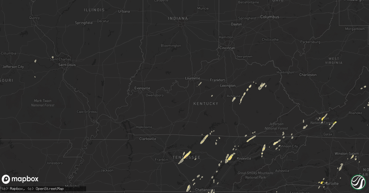
Hail Map in Kentucky on June 10, 2014
Get this storm
June 10 map
$229
one time, instant access
Download today. No call, no setup
Keep the $229
Bought the map and want the full workflow? Apply the entire $229 to a subscription within 7 days. None of it is wasted.
Every map, not just this one
This buys you this map. Subscription and you get every map we run, in the markets you choose from a few cities to whole states to nationwide. Plus real-time alerts the moment a storm fires.
Contact data
Name, contact info, occupancy, even credit band for addresses in the footprint. You go from where it hit to who to call.
Become the source they trust
Unlimited branding weather history reports on demand. You already have the documented answer ready for the property owner, and you are the one who showed up with it.
Property data and RoofTrace estimates
Pull up any address you have got, its value and the exact code rules for that jurisdiction, straight from One Click Code. Then RoofTrace estimates the squares, pitch, and roof value, priced the way you price.
Storm reports in Kentucky
Kentucky
| Date | Description |
|---|---|
| 06/10/20146:57 PM CDT | Trees down. |
| 06/10/20146:57 PM CDT | Trees down. |
| 06/10/20146:55 PM CDT | Trees branches down |
| 06/10/20146:52 PM CDT | Numerous trees and power lines down. |
| 06/10/20146:52 PM CDT | Tree blown down on power line on highway 122. |
| 06/10/20146:52 PM CDT | Tree down between mile marker 8 and 9 on ky 114 |
| 06/10/20146:50 PM CDT | One tree down on route 40 west east side of paintsville. |
| 06/10/20146:48 PM CDT | One tree down on route 1559. |
| 06/10/20146:45 PM CDT | Trees down on power lines |
| 06/10/20146:43 PM CDT | Tree down between mile marker 8 and 9 on ky 114 |
| 06/10/20146:40 PM CDT | One tree down on route 40 east. |
| 06/10/20146:36 PM CDT | Trees down. |
| 06/10/20146:31 PM CDT | Numerous trees down on highway 519. |
| 06/10/20146:31 PM CDT | Numerous trees down on highway 32. |
| 06/10/20146:28 PM CDT | Large limbs down. Some trees uprooted and power lines down. |
| 06/10/20146:28 PM CDT | Trees down. |
| 06/10/20146:28 PM CDT | Large limbs down. Some trees uprooted and power lines down. |
| 06/10/20146:28 PM CDT | Trees and large limbs down at carr creek lake park. |
| 06/10/20146:27 PM CDT | Numerous trees down on highways 460...867 and 40. |
| 06/10/20146:20 PM CDT | Trees down. |
| 06/10/20146:18 PM CDT | One large branch downed |
| 06/10/20146:18 PM CDT | Tree down on a trailer. |
| 06/10/20146:16 PM CDT | One large tree was blown down. The time of the event is estimated from radar. |
| 06/10/20146:15 PM CDT | Numerous trees down. |
| 06/10/20146:13 PM CDT | Multiple large tree limbs were blown down between milemarkers 32 and 35. |
| 06/10/20146:13 PM CDT | Large tree limbs blown down on highway 30. |
| 06/10/20146:12 PM CDT | Large limbs down. Estimated wind speed of 60 mph. Pea size hail. |
| 06/10/20146:11 PM CDT | Numerous trees down. |
| 06/10/20146:10 PM CDT | Tree was blown down along u.s. Route 460 near the county line. |
| 06/10/20146:10 PM CDT | Large branch was blown down. |
| 06/10/20146:08 PM CDT | Part of a roof was blown off a store. |
| 06/10/20146:05 PM CDT | Large tree was blown down on ky route 205. Several large branches were also blown down. |
| 06/10/20146:05 PM CDT | Tree down on a trailer. |
| 06/10/20146:03 PM CDT | Several trees down. |
| 06/10/20146:02 PM CDT | Numerous trees down. |
| 06/10/20146:00 PM CDT | Large tree limbs blown down on highway 30. |
| 06/10/20145:59 PM CDT | Large branch was blown down along ky route 205. |
| 06/10/20145:57 PM CDT | Trees and power lines down. |
| 06/10/20145:55 PM CDT | A couple trees downed on route 8 |
| 06/10/20145:55 PM CDT | Half a roof blown off a trailer on quicksand road. |
| 06/10/20145:55 PM CDT | Tree down on kentucky ave. |
| 06/10/20145:52 PM CDT | Multiple trees down. Houses and barns damaged. |
| 06/10/20145:50 PM CDT | Snapped trees. Broke power poles. Blew siding off a home. |
| 06/10/20145:46 PM CDT | Numerous trees down and power outages. |
| 06/10/20145:45 PM CDT | Trees were blown down along u.s. Route 460 near bourbon county line. |
| 06/10/20145:43 PM CDT | Numerous trees were blown down along u.s. 460 near the eastern edge of montgomery county. |
| 06/10/20145:40 PM CDT | Shingles off of buidling and numerous trees down. |
| 06/10/20145:39 PM CDT | Trees down on highway 11 north. |
| 06/10/20145:39 PM CDT | Numerous trees down |
| 06/10/20145:39 PM CDT | Numerous trees down. |
| 06/10/20145:39 PM CDT | Numerous trees down. |
| 06/10/20145:39 PM CDT | Numerous trees down on sugar camp road. |
| 06/10/20145:39 PM CDT | Two trees on belle point road. |
| 06/10/20145:38 PM CDT | Mulitple trees down along evelyn road and highway 2453. |
| 06/10/20145:35 PM CDT | Barn destroyed. |
| 06/10/20145:30 PM CDT | Large tree limbs over 2 inches blown down from bradford pear and oak tree. Trampoline also blown across fence. |
| 06/10/20145:30 PM CDT | 5 inch diameter 25 foot tall tree blown down. Large cupboard on porch toppled. |
| 06/10/20145:29 PM CDT | Unanchored trailer toppled on kentucky 1071. |
| 06/10/20145:25 PM CDT | Trees down. |
| 06/10/20145:24 PM CDT | Numerous trees down on highway 11 south. |
| 06/10/20145:24 PM CDT | Numerous trees down on highway 80. |
| 06/10/20145:22 PM CDT | Trees down. |
| 06/10/20145:20 PM CDT | Multiple trees down on highway 52 |
| 06/10/20145:15 PM CDT | Trees down at mt. Vernon road and liberty avenue... Hwy 421 and battlefield road... And near waco baptist church. |
| 06/10/20145:15 PM CDT | Large limbs down. |
| 06/10/20145:05 PM CDT | Tree down on house. |
| 06/10/20145:05 PM CDT | 3 foot diameter tree down and outbuildings destroyed at west end of london airport/loz. |
| 06/10/20145:05 PM CDT | A local report indicates 58 MPH wind near LONDON |
| 06/10/20145:00 PM CDT | Numerous trees down. |
| 06/10/20145:00 PM CDT | Roof damage at fire house. Tree down on highway 26. |
| 06/10/20145:00 PM CDT | Tree fell on trailer and destroyed trailer. |
| 06/10/20144:59 PM CDT | 60 foot tree fell across street from woodbine fire department. |
| 06/10/20144:58 PM CDT | 60 foot tree fell across street from woodbine fire department. Event time is estimated from radar. |
| 06/10/20144:58 PM CDT | A tree down on paint lick road. |
| 06/10/20144:55 PM CDT | Numerous trees down. Time of event was estimated from radar. |
| 06/10/20144:55 PM CDT | Tree down on bee creek road. |
| 06/10/20144:55 PM CDT | Trees down. |
| 06/10/20144:50 PM CDT | Tree fell on trailer and destroyed trailer. The time of the event is estimted from radar. |
| 06/10/20144:35 PM CDT | Roof damage at murphy subdivision. |
| 06/10/20144:35 PM CDT | Trees down at 92 west at hilltop. |
| 06/10/20144:35 PM CDT | Trees down at worley. |
| 06/10/20144:35 PM CDT | Trees down. |
| 06/10/20143:55 PM CDT | Tree down. |
| 06/10/20143:30 PM CDT | Numerous trees down. Power and phone lines down. |
| 06/10/20143:13 PM CDT | Trees down in roadways. Limbs down on vehicles. Some power lines down. |
| 06/10/20142:50 PM CDT | Tree blown down on house on state route 1247. |
| 06/10/20142:50 PM CDT | Trees and power lines down in northeast somerset. |
| 06/10/20142:45 PM CDT | A trained spotter reported that he observed three inch diameter tree limbs that had just been blown down by thunderstorm wind gusts about half a mile west of the inters |
| 06/10/20142:30 PM CDT | Trees down in albany. |
| 06/09/20147:20 PM CDT | Trees and power lines down. |
| 06/09/20147:17 PM CDT | Large tree down. |
| 06/09/20147:14 PM CDT | Numerous trees down on route 40. |
| 06/09/20147:14 PM CDT | Numerous trees down on highway 1714. |
| 06/09/20147:10 PM CDT | Multiple trees down near 1840 hoods creek pike road |
| 06/09/20147:10 PM CDT | Report of at least 10 trees down in community of westwood ky. Several trees landed on homes...vehicles...and power lines. |
| 06/09/20147:08 PM CDT | Several trees down near neade springs rd. |
| 06/09/20147:05 PM CDT | Trees down on residence 4335 poor bottom rd. |
| 06/09/20147:05 PM CDT | Several trees blown down. |
| 06/09/20147:05 PM CDT | Trees down on residence 4335 poor bottom rd. |
| 06/09/20147:05 PM CDT | Power poles snapped on chloe road...river view drive...myra barnes avenue and cedar creek roads.trees and powerlines on vehicles at various locations. |
| 06/09/20147:05 PM CDT | Power line down on house at 2826 island creek road. |
| 06/09/20147:00 PM CDT | Tree fell on residence. |
All States Impacted by Hail Map on June 10, 2014
Cities Impacted by Hail Map on June 10, 2014
- Pamplin, VA
- Prospect, VA
- Reed Point, MT
- Gadsden, AL
- Centre, AL
- Leesburg, AL
- Collinsville, AL
- Liberty, TN
- Lakeland, FL
- Belle Fourche, SD
- Nisland, SD
- Mooresburg, TN
- Whitesburg, TN
- Fort Payne, AL
- Moore, MT
- Nahunta, GA
- Tallassee, AL
- Leesburg, FL
- Sanderson, FL
- White Pine, TN
- Rock Spring, GA
- Ringgold, GA
- Morristown, TN
- Russellville, TN
- Sequatchie, TN
- Tracy City, TN
- Metter, GA
- Preston, GA
- Jesup, GA
- Hortense, GA
- Inverness, FL
- Monroe, VA
- Forest, VA
- Big Island, VA
- Lynchburg, VA
- Madison Heights, VA
- Coleman Falls, VA
- Morgan, GA
- Kaycee, WY
- Harrison, NE
- Edgemont, SD
- Dahlonega, GA
- Cleveland, GA
- Minter, AL
- Beatrice, AL
- Tyler, AL
- Pine Apple, AL
- Sardis, AL
- Oliver Springs, TN
- Wartburg, TN
- Vesuvius, VA
- Roseland, VA
- Amherst, VA
- Bland, VA
- Fort McCoy, FL
- Oak Ridge, TN
- Kingston, TN
- Briceville, TN
- Harriman, TN
- Clinton, TN
- Verbena, AL
- Clanton, AL
- Stanton, KY
- Means, KY
- Jeffersonville, KY
- Frenchburg, KY
- Cumberland Gap, TN
- Surrency, GA
- Odum, GA
- Glennville, GA
- Clover, SC
- Berea, KY
- Richmond, KY
- Greeneville, TN
- Rogersville, TN
- Rainsville, AL
- Sylvania, AL
- Geneva, FL
- Sherwood, TN
- Sewanee, TN
- Prattville, AL
- Billingsley, AL
- Marbury, AL
- Wytheville, VA
- Loxahatchee, FL
- East Dublin, GA
- Rockledge, GA
- Clay City, KY
- Polk City, FL
- Groveland, FL
- Sylacauga, AL
- Trenton, SC
- Aiken, SC
- Salt Lick, KY
- Morehead, KY
- Dunlap, TN
- Mulberry, FL
- Lumberton, MS
- Bulls Gap, TN
- Camden, AL
- Lexington, NC
- Winston Salem, NC
- Greenville, AL
- McKenzie, AL
- Georgiana, AL
- Caryville, TN
- Lowell, NC
- Gastonia, NC
- Alachua, FL
- Brooker, FL
- Appomattox, VA
- Junction City, GA
- Talbotton, GA
- Lithia, FL
- Newport, TN
- Dandridge, TN
- West Liberty, KY
- Limestone, TN
- Monroe, TN
- Byrdstown, TN
- Albany, KY
- Livingston, TN
- Hilham, TN
- Allons, TN
- Concord, NC
- Mount Pleasant, NC
- Colfax, NC
- High Point, NC
- Thomasville, NC
- Kernersville, NC
- Dayton, TN
- Evensville, TN
- Glade Spring, VA
- Marion, VA
- Saltville, VA
- Jamestown, NC
- Hiwassee, VA
- Auburntown, TN
- Hickman, TN
- Woodbury, TN
- Alexandria, TN
- Lancaster, TN
- Dowelltown, TN
- Kingsport, TN
- Palmer, TN
- Gillette, WY
- Blairsville, GA
- Montgomery, AL
- Ceres, VA
- Umatilla, FL
- Eustis, FL
- Gladstone, VA
- Grandview, TN
- Spring City, TN
- Deland, FL
- Ragland, AL
- Lincoln, AL
- Riverside, AL
- Pell City, AL
- Johnston, SC
- Olympia, KY
- Omaha, GA
- Lumpkin, GA
- Hoboken, GA
- Howey In The Hills, FL
- Sorrento, FL
- Mount Dora, FL
- Saint Cloud, FL
- Taylorsville, KY
- Mount Washington, KY
- Louisville, KY
- Dade City, FL
- Sale Creek, TN
- Bedford, VA
- Georgetown, GA
- Millboro, VA
- Pearl, IL
- Stevenson, AL
- South Pittsburg, TN
- Bridgeport, AL
- Cullman, AL
- Vinemont, AL
- Gaylesville, AL
- Sturgis, SD
- New Underwood, SD
- Irvine, KY
- Claxton, GA
- Rising Fawn, GA
- Menlo, GA
- Mentone, AL
- Weogufka, AL
- Goodwater, AL
- Raiford, FL
- Ridge Spring, SC
- Farmville, VA
- La Fayette, GA
- Sandy Hook, KY
- Greensboro, NC
- Auburndale, FL
- Wentzville, MO
- O'Fallon, MO
- Clermont, FL
- Ward, SC
- Robertsdale, AL
- Fort Gaines, GA
- Lewistown, MT
- Stanley, NC
- Mount Holly, NC
- Apopka, FL
- Shorter, AL
- Hardaway, AL
- Waycross, GA
- Hermann, MO
- Titus, AL
- Bowling Green, FL
- Piedmont, AL
- Jacksonville, AL
- Forest Home, AL
- Millbrook, AL
- Lowndesboro, AL
- Dawson, GA
- Fitzpatrick, AL
- Portal, GA
- Statesboro, GA
- Hillsville, VA
- Max Meadows, VA
- Austinville, VA
- Fellsmere, FL
- Bristol, TN
- Troy, AL
- Bristol, VA
- Kissimmee, FL
- Davenport, FL
- Greybull, WY
- Lovell, WY
- Booth, AL
- Rockwood, TN
- Tucker, GA
- Atlanta, GA
- Chatham, VA
- Burlington, NC
- Red Level, AL
- Dozier, AL
- Orange Park, FL
- Middleburg, FL
- Green Cove Springs, FL
- Harrogate, TN
- Saint George, GA
- Folkston, GA
- Rocky Top, TN
- Randleman, NC
- Linwood, NC
- Clearmont, WY
- Arvada, WY
- Jamestown, TN
- Crescent City, FL
- Leary, GA
- Pickens, SC
- Jacksonville, FL
- Cropwell, AL
- Wetumpka, AL
- Chuckey, TN
- Afton, TN
- McKee, KY
- Weston, WY
- Newell, SD
- Interlachen, FL
- Readyville, TN
- Milton, TN
- Elmwood, TN
- Buffalo Valley, TN
- Silver Point, TN
- Lawtey, FL
- Starke, FL
- Dawson, AL
- Wellington, AL
- Punta Gorda, FL
- Walling, TN
- Sparta, TN
- Honoraville, AL
- Rutledge, AL
- Elmore, AL
- Salisbury, NC
- Spencer, NC
- Decatur, GA
- Scottdale, GA
- Clarkston, GA
- Selma, AL
- Miracle, KY
- Blackshear, GA
- Autaugaville, AL
- Palatka, FL
- Manville, WY
- Nickelsville, VA
- Gate City, VA
- Bastian, VA
- Charlotte, NC
- Hilliard, FL
- Pelham, GA
- Cleveland, TN
- Eaton Park, FL
- Ooltewah, TN
- Apison, TN
- Cedar Bluff, VA
- Pounding Mill, VA
- Harrisburg, NE
- Chilhowie, VA
- Meadowview, VA
- Coalmont, TN
- Immokalee, FL
- Labelle, FL
- Zolfo Springs, FL
- Arcadia, FL
- Batesburg, SC
- Bush, LA
- Bogalusa, LA
- Speedwell, TN
- Tazewell, TN
- New Tazewell, TN
- Winter Haven, FL
- Alpha, KY
- Monticello, KY
- Goode, VA
- Hanceville, AL
- Hernando, FL
- Bartow, FL
- Cohutta, GA
- Tunnel Hill, GA
- Rocky Face, GA
- Warrenton, MO
- Berger, MO
- Watertown, TN
- Brush Creek, TN
- Ocala, FL
- Port Saint Lucie, FL
- Pierson, FL
- Seville, FL
- Dunnellon, FL
- Cairo, GA
- Indiantown, FL
- Rentz, GA
- Dublin, GA
- Corolla, NC
- Deatsville, AL
- East Palatka, FL
- Draper, VA
- Scottsboro, AL
- Ewing, VA
- Woodville, AL
- Mackville, KY
- Harrodsburg, KY
- Springfield, KY
- Poplarville, MS
- Graniteville, SC
- North Augusta, SC
- Wrightsville, GA
- Spout Spring, VA
- Concord, VA
- Anniston, AL
- Ohatchee, AL
- Millen, GA
- La Follette, TN
- Jacksboro, TN
- Arlington, GA
- Eclectic, AL
- Paint Lick, KY
- Richland, GA
- Cuba, MO
- Rosebud, MO
- Georgetown, TN
- Birchwood, TN
- Pall Mall, TN
- Haines City, FL
- Pike Road, AL
- Tuskegee, AL
- Cecil, AL
- Ravenna, KY
- Chickamauga, GA
- Middlesboro, KY
- Faith, SD
- Hill City, SD
- Glenwood, AL
- Elba, AL
- Church Hill, TN
- Burkesville, KY
- Patterson, GA
- Webster, FL
- Center Hill, FL
- Clayton, GA
- Tiger, GA
- Clarkesville, GA
- New Hope, AL
- Grant, AL
- Ezel, KY
- Reidsville, GA
- Sylvester, GA
- Ashburn, GA
- Warwick, GA
- Tavares, FL
- Rockford, AL
- Wood, SD
- Valley Head, AL
- Big Timber, MT
- Rapelje, MT


