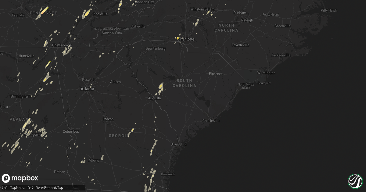
Hail Map in South Carolina on June 10, 2014
Get this storm
June 10 map
$229
one time, instant access
Download today. No call, no setup
Keep the $229
Bought the map and want the full workflow? Apply the entire $229 to a subscription within 7 days. None of it is wasted.
Every map, not just this one
This buys you this map. Subscription and you get every map we run, in the markets you choose from a few cities to whole states to nationwide. Plus real-time alerts the moment a storm fires.
Contact data
Name, contact info, occupancy, even credit band for addresses in the footprint. You go from where it hit to who to call.
Become the source they trust
Unlimited branding weather history reports on demand. You already have the documented answer ready for the property owner, and you are the one who showed up with it.
Property data and RoofTrace estimates
Pull up any address you have got, its value and the exact code rules for that jurisdiction, straight from One Click Code. Then RoofTrace estimates the squares, pitch, and roof value, priced the way you price.
Storm reports in South Carolina
South Carolina
| Date | Description |
|---|---|
| 06/10/201412:45 AM CDT | Tree down on hwy 560 |
| 06/10/201412:30 AM CDT | Tree down on milam rd in clinton |
| 06/10/201412:21 AM CDT | Trees down on graham rd at graham cemetery rd. |
| 06/10/201412:21 AM CDT | Trees down on us hwy 76 and ramage rd. |
| 06/10/201412:12 AM CDT | Trees down on a house on mt. Bethel garmany rd. No injuries. |
| 06/09/201411:55 PM CDT | Trees down on wheeland rd. |
| 06/09/201411:55 PM CDT | Trees down on old dutch rd. |
| 06/09/201411:50 PM CDT | Trees down between leesville and summit near sandpit rd and broad st. Reported by schp |
| 06/09/201411:42 PM CDT | Saluda dispatch reported trees down on hwy 178 at white acre rd. |
| 06/09/201411:38 PM CDT | Saluda dispatch reported a tree fell on a vehicle on hwy 178 at mt. Willing rd. No injuries were reported. |
| 06/09/201411:25 PM CDT | Saluda dispatch reported trees down in saluda near hwy 194. |
| 06/09/201411:24 PM CDT | Saluda dispatch reported multiple trees down in the ridge spring area. |
| 06/09/201411:12 PM CDT | Trees down at piper rd and mt. Calvary rd |
| 06/09/201411:05 PM CDT | Trees down on train tracks near main st and hwy 421 in graniteville. Train stuck on tracks as a result. |
| 06/09/201411:02 PM CDT | Trees and power lines down at belvedere-clearwater rd and irene st in clearwater. |
| 06/09/201411:00 PM CDT | Trees down and power lines and poles down at lily ave and cherokee dr |
| 06/09/201411:00 PM CDT | Sc highway patrol reports tree down on lakeview dr. At clearwater rd. |
| 06/09/20147:09 PM CDT | One tree down on mormon church rd. Another down on black lash bay dr. |
All States Impacted by Hail Map on June 10, 2014
Cities Impacted by Hail Map on June 10, 2014
- Pamplin, VA
- Prospect, VA
- Reed Point, MT
- Gadsden, AL
- Centre, AL
- Leesburg, AL
- Collinsville, AL
- Liberty, TN
- Lakeland, FL
- Belle Fourche, SD
- Nisland, SD
- Mooresburg, TN
- Whitesburg, TN
- Fort Payne, AL
- Moore, MT
- Nahunta, GA
- Tallassee, AL
- Leesburg, FL
- Sanderson, FL
- White Pine, TN
- Rock Spring, GA
- Ringgold, GA
- Morristown, TN
- Russellville, TN
- Sequatchie, TN
- Tracy City, TN
- Metter, GA
- Preston, GA
- Jesup, GA
- Hortense, GA
- Inverness, FL
- Monroe, VA
- Forest, VA
- Big Island, VA
- Lynchburg, VA
- Madison Heights, VA
- Coleman Falls, VA
- Morgan, GA
- Kaycee, WY
- Harrison, NE
- Edgemont, SD
- Dahlonega, GA
- Cleveland, GA
- Minter, AL
- Beatrice, AL
- Tyler, AL
- Pine Apple, AL
- Sardis, AL
- Oliver Springs, TN
- Wartburg, TN
- Vesuvius, VA
- Roseland, VA
- Amherst, VA
- Bland, VA
- Fort McCoy, FL
- Oak Ridge, TN
- Kingston, TN
- Briceville, TN
- Harriman, TN
- Clinton, TN
- Verbena, AL
- Clanton, AL
- Stanton, KY
- Means, KY
- Jeffersonville, KY
- Frenchburg, KY
- Cumberland Gap, TN
- Surrency, GA
- Odum, GA
- Glennville, GA
- Clover, SC
- Berea, KY
- Richmond, KY
- Greeneville, TN
- Rogersville, TN
- Rainsville, AL
- Sylvania, AL
- Geneva, FL
- Sherwood, TN
- Sewanee, TN
- Prattville, AL
- Billingsley, AL
- Marbury, AL
- Wytheville, VA
- Loxahatchee, FL
- East Dublin, GA
- Rockledge, GA
- Clay City, KY
- Polk City, FL
- Groveland, FL
- Sylacauga, AL
- Trenton, SC
- Aiken, SC
- Salt Lick, KY
- Morehead, KY
- Dunlap, TN
- Mulberry, FL
- Lumberton, MS
- Bulls Gap, TN
- Camden, AL
- Lexington, NC
- Winston Salem, NC
- Greenville, AL
- McKenzie, AL
- Georgiana, AL
- Caryville, TN
- Lowell, NC
- Gastonia, NC
- Alachua, FL
- Brooker, FL
- Appomattox, VA
- Junction City, GA
- Talbotton, GA
- Lithia, FL
- Newport, TN
- Dandridge, TN
- West Liberty, KY
- Limestone, TN
- Monroe, TN
- Byrdstown, TN
- Albany, KY
- Livingston, TN
- Hilham, TN
- Allons, TN
- Concord, NC
- Mount Pleasant, NC
- Colfax, NC
- High Point, NC
- Thomasville, NC
- Kernersville, NC
- Dayton, TN
- Evensville, TN
- Glade Spring, VA
- Marion, VA
- Saltville, VA
- Jamestown, NC
- Hiwassee, VA
- Auburntown, TN
- Hickman, TN
- Woodbury, TN
- Alexandria, TN
- Lancaster, TN
- Dowelltown, TN
- Kingsport, TN
- Palmer, TN
- Gillette, WY
- Blairsville, GA
- Montgomery, AL
- Ceres, VA
- Umatilla, FL
- Eustis, FL
- Gladstone, VA
- Grandview, TN
- Spring City, TN
- Deland, FL
- Ragland, AL
- Lincoln, AL
- Riverside, AL
- Pell City, AL
- Johnston, SC
- Olympia, KY
- Omaha, GA
- Lumpkin, GA
- Hoboken, GA
- Howey In The Hills, FL
- Sorrento, FL
- Mount Dora, FL
- Saint Cloud, FL
- Taylorsville, KY
- Mount Washington, KY
- Louisville, KY
- Dade City, FL
- Sale Creek, TN
- Bedford, VA
- Georgetown, GA
- Millboro, VA
- Pearl, IL
- Stevenson, AL
- South Pittsburg, TN
- Bridgeport, AL
- Cullman, AL
- Vinemont, AL
- Gaylesville, AL
- Sturgis, SD
- New Underwood, SD
- Irvine, KY
- Claxton, GA
- Rising Fawn, GA
- Menlo, GA
- Mentone, AL
- Weogufka, AL
- Goodwater, AL
- Raiford, FL
- Ridge Spring, SC
- Farmville, VA
- La Fayette, GA
- Sandy Hook, KY
- Greensboro, NC
- Auburndale, FL
- Wentzville, MO
- O'Fallon, MO
- Clermont, FL
- Ward, SC
- Robertsdale, AL
- Fort Gaines, GA
- Lewistown, MT
- Stanley, NC
- Mount Holly, NC
- Apopka, FL
- Shorter, AL
- Hardaway, AL
- Waycross, GA
- Hermann, MO
- Titus, AL
- Bowling Green, FL
- Piedmont, AL
- Jacksonville, AL
- Forest Home, AL
- Millbrook, AL
- Lowndesboro, AL
- Dawson, GA
- Fitzpatrick, AL
- Portal, GA
- Statesboro, GA
- Hillsville, VA
- Max Meadows, VA
- Austinville, VA
- Fellsmere, FL
- Bristol, TN
- Troy, AL
- Bristol, VA
- Kissimmee, FL
- Davenport, FL
- Greybull, WY
- Lovell, WY
- Booth, AL
- Rockwood, TN
- Tucker, GA
- Atlanta, GA
- Chatham, VA
- Burlington, NC
- Red Level, AL
- Dozier, AL
- Orange Park, FL
- Middleburg, FL
- Green Cove Springs, FL
- Harrogate, TN
- Saint George, GA
- Folkston, GA
- Rocky Top, TN
- Randleman, NC
- Linwood, NC
- Clearmont, WY
- Arvada, WY
- Jamestown, TN
- Crescent City, FL
- Leary, GA
- Pickens, SC
- Jacksonville, FL
- Cropwell, AL
- Wetumpka, AL
- Chuckey, TN
- Afton, TN
- McKee, KY
- Weston, WY
- Newell, SD
- Interlachen, FL
- Readyville, TN
- Milton, TN
- Elmwood, TN
- Buffalo Valley, TN
- Silver Point, TN
- Lawtey, FL
- Starke, FL
- Dawson, AL
- Wellington, AL
- Punta Gorda, FL
- Walling, TN
- Sparta, TN
- Honoraville, AL
- Rutledge, AL
- Elmore, AL
- Salisbury, NC
- Spencer, NC
- Decatur, GA
- Scottdale, GA
- Clarkston, GA
- Selma, AL
- Miracle, KY
- Blackshear, GA
- Autaugaville, AL
- Palatka, FL
- Manville, WY
- Nickelsville, VA
- Gate City, VA
- Bastian, VA
- Charlotte, NC
- Hilliard, FL
- Pelham, GA
- Cleveland, TN
- Eaton Park, FL
- Ooltewah, TN
- Apison, TN
- Cedar Bluff, VA
- Pounding Mill, VA
- Harrisburg, NE
- Chilhowie, VA
- Meadowview, VA
- Coalmont, TN
- Immokalee, FL
- Labelle, FL
- Zolfo Springs, FL
- Arcadia, FL
- Batesburg, SC
- Bush, LA
- Bogalusa, LA
- Speedwell, TN
- Tazewell, TN
- New Tazewell, TN
- Winter Haven, FL
- Alpha, KY
- Monticello, KY
- Goode, VA
- Hanceville, AL
- Hernando, FL
- Bartow, FL
- Cohutta, GA
- Tunnel Hill, GA
- Rocky Face, GA
- Warrenton, MO
- Berger, MO
- Watertown, TN
- Brush Creek, TN
- Ocala, FL
- Port Saint Lucie, FL
- Pierson, FL
- Seville, FL
- Dunnellon, FL
- Cairo, GA
- Indiantown, FL
- Rentz, GA
- Dublin, GA
- Corolla, NC
- Deatsville, AL
- East Palatka, FL
- Draper, VA
- Scottsboro, AL
- Ewing, VA
- Woodville, AL
- Mackville, KY
- Harrodsburg, KY
- Springfield, KY
- Poplarville, MS
- Graniteville, SC
- North Augusta, SC
- Wrightsville, GA
- Spout Spring, VA
- Concord, VA
- Anniston, AL
- Ohatchee, AL
- Millen, GA
- La Follette, TN
- Jacksboro, TN
- Arlington, GA
- Eclectic, AL
- Paint Lick, KY
- Richland, GA
- Cuba, MO
- Rosebud, MO
- Georgetown, TN
- Birchwood, TN
- Pall Mall, TN
- Haines City, FL
- Pike Road, AL
- Tuskegee, AL
- Cecil, AL
- Ravenna, KY
- Chickamauga, GA
- Middlesboro, KY
- Faith, SD
- Hill City, SD
- Glenwood, AL
- Elba, AL
- Church Hill, TN
- Burkesville, KY
- Patterson, GA
- Webster, FL
- Center Hill, FL
- Clayton, GA
- Tiger, GA
- Clarkesville, GA
- New Hope, AL
- Grant, AL
- Ezel, KY
- Reidsville, GA
- Sylvester, GA
- Ashburn, GA
- Warwick, GA
- Tavares, FL
- Rockford, AL
- Wood, SD
- Valley Head, AL
- Big Timber, MT
- Rapelje, MT


