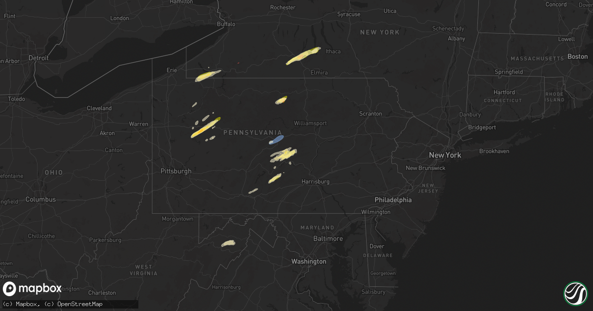
Hail Map in Pennsylvania on June 9, 2025
Get this storm
June 9 map
$229
one time, instant access
Download today. No call, no setup
Keep the $229
Bought the map and want the full workflow? Apply the entire $229 to a subscription within 7 days. None of it is wasted.
Every map, not just this one
This buys you this map. Subscription and you get every map we run, in the markets you choose from a few cities to whole states to nationwide. Plus real-time alerts the moment a storm fires.
Contact data
Name, contact info, occupancy, even credit band for addresses in the footprint. You go from where it hit to who to call.
Become the source they trust
Unlimited branding weather history reports on demand. You already have the documented answer ready for the property owner, and you are the one who showed up with it.
Property data and RoofTrace estimates
Pull up any address you have got, its value and the exact code rules for that jurisdiction, straight from One Click Code. Then RoofTrace estimates the squares, pitch, and roof value, priced the way you price.
Storm reports in Pennsylvania
Pennsylvania
| Date | Description |
|---|---|
| 06/09/20256:23 PM CDT | Numerous trees down along cemetery hill road and laurel ridge road. |
| 06/09/20256:15 PM CDT | Trees and wires down blocking a roadway near 22nd street and logan avenue. |
| 06/09/20256:15 PM CDT | Tree down across the roadway on bellemeade drive near linwood road. |
| 06/09/20256:05 PM CDT | Picture on facebook page |
| 06/09/20255:58 PM CDT | Tree down on us 322 near spencer ln. |
| 06/09/20255:29 PM CDT | Tree down over the road with lines blocking the roadway. |
| 06/09/20255:29 PM CDT | Tree down over the road with lines blocking the |
| 06/09/20254:52 PM CDT | Several barns and numerous trees damaged in the area. Possible tornado damage. |
| 06/09/20254:49 PM CDT | An ef-2 tornado tracked northeast across knowle road. The tornado destroyed two barns and damaged the siding and wind |
| 06/09/20254:45 PM CDT | Time estimated by radar. Tree down over the road with power lines blocking the roadway on route 949. Possible tornado. |
| 06/09/20254:45 PM CDT | Time estimated by radar. Tree down over the road with power li |
| 06/09/20254:43 PM CDT | Corrects time of previous tstm wnd dmg report from 1 ese sigel. Tree down over the road with lines blocking the roadway. |
| 06/09/20254:31 PM CDT | Tree down along route 322 just west of exit 70 on i-80. |
| 06/09/20254:29 PM CDT | Large limbs down near mile marker 67 along i-80. Possible tornado. |
| 06/09/20254:29 PM CDT | Trees uprooted along brush run rd. Possible tornado. |
| 06/09/20254:27 PM CDT | Corrected time. Ef-0 tornado confirmed just north of limestone. |
| 06/09/20254:26 PM CDT | Ef-0 tornado confirmed just north of limestone. |
| 06/09/20254:24 PM CDT | Trees down in the town of limestone. Time estimated via radar. |
| 06/09/20254:10 PM CDT | Picture of hail next to ruler sent from em near sligo... Pa. |
| 06/09/20253:41 PM CDT | Tree down near the intersection of sutton road and route 958. |
| 06/09/20253:09 PM CDT | Multiple trees down onto houses in columbus township. |
| 06/09/20253:02 PM CDT | Minor roof damage to a barn and tree damage. |
| 06/09/20252:46 PM CDT | Local public safety scanner reported a tree down on payne avenue. Time estimated via radar. |
| 06/09/20252:46 PM CDT | Numerous trees downed in and around canadohta lake. |
| 06/09/20252:45 PM CDT | The national weather service in cleveland confirmed an ef0 tornado in the canadohta lake area. Large tree limbs from a nearby tree were blown onto a home... Resulting i |
| 06/09/20252:45 PM CDT | County public safety scanner reported a tree down on wires on lake road. Time estimated via radar. |
| 06/08/202510:10 PM CDT | Two trees fell on a house and into a bedroom. |
| 06/08/20258:28 PM CDT | Multiple reports of quarter sized hail at the rutters in milroy. |
| 06/08/20258:27 PM CDT | A local report indicates 1.25 inch wind near Reedsville |
| 06/08/20258:05 PM CDT | Tree and wires down on greenwood road. |
| 06/08/20257:46 PM CDT | Trees and wires down on hartslog valley road near the intersection of blue moon road. |
| 06/08/20257:41 PM CDT | Trees and wires down on summit school road. |
| 06/08/20257:40 PM CDT | Trees and wires down onto wesley chapel road. |
| 06/08/20257:20 PM CDT | Multiple trees and wires down in the milesburg area. |
All States Impacted by Hail Map on June 9, 2025
Cities Impacted by Hail Map on June 9, 2025
- Hermleigh, TX
- Snyder, TX
- Randolph, AL
- Roscoe, TX
- Loraine, TX
- Brierfield, AL
- Sweetwater, TX
- Nolan, TX
- Blackwell, TX
- Tuscola, TX
- Wingate, TX
- Ovalo, TX
- Winters, TX
- Talpa, TX
- Ballinger, TX
- Patterson, GA
- Blackshear, GA
- Ochlocknee, GA
- Moultrie, GA
- Hartford, AL
- Dothan, AL
- Slocomb, AL
- Valdosta, GA
- Quitman, GA
- Adel, GA
- Jackson, AL
- Pavo, GA
- Gainestown, AL
- Weston, CO
- Frisco City, AL
- Uriah, AL
- Williston, TN
- Moscow, TN
- Bainbridge, GA
- Somerville, TN
- Rickman, TN
- Cookeville, TN
- Folkston, GA
- Livingston, TN
- Kewadin, MI
- Ellsworth, MI
- Harbor Springs, MI
- Howard, CO
- Evergreen, AL
- Tererro, NM
- Lyons, GA
- Cotopaxi, CO
- Ocate, NM
- Levering, MI
- Pellston, MI
- Castleberry, AL
- Santa Fe, NM
- Carp Lake, MI
- Pleasantville, PA
- Oil City, PA
- Andalusia, AL
- Red Level, AL
- Tierra Amarilla, NM
- Mackinaw City, MI
- Bonifay, FL
- State Line, MS
- Leakesville, MS
- Brewton, AL
- Mountainair, NM
- Sugar Grove, PA
- Panama, NY
- Bear Lake, PA
- Ashville, NY
- Columbus, PA
- Register, GA
- Metter, GA
- Arroyo Hondo, NM
- Indian River, MI
- Westville, FL
- Statesboro, GA
- Jamestown, NY
- Raton, NM
- Cheboygan, MI
- Lakewood, NY
- Pittsfield, PA
- Cripple Creek, CO
- Kinross, MI
- Callensburg, PA
- Emlenton, PA
- Sligo, PA
- Parker, PA
- Leeper, PA
- Lucinda, PA
- Kennedy, NY
- Falconer, NY
- Frewsburg, NY
- Des Moines, NM
- Flomaton, AL
- Eckerman, MI
- Rimersburg, PA
- Johannesburg, MI
- Florissant, CO
- Gaylord, MI
- Karns City, PA
- East Brady, PA
- Fort Meade, FL
- Estancia, NM
- Torreon, NM
- Marienville, PA
- Vowinckel, PA
- Vinegar Bend, AL
- Randolph, NY
- New Bethlehem, PA
- Clarion, PA
- Summerville, PA
- Strattanville, PA
- Corsica, PA
- Haines City, FL
- Huger, SC
- Atmore, AL
- Magdalena, NM
- Grenville, NM
- Shippenville, PA
- Knox, PA
- Little River, AL
- Citronelle, AL
- Chunchula, AL
- Hastings, MI
- Summerville, SC
- Ladson, SC
- Goose Creek, SC
- Charleston, SC
- Hanahan, SC
- Awendaw, SC
- Tijeras, NM
- Sigel, PA
- Brookville, PA
- Great Valley, NY
- Freeport, MI
- Lake Odessa, MI
- Winter Haven, FL
- Cerrillos, NM
- Ona, WV
- Atlanta, MI
- Salida, CO
- Cuba, NM
- Jemez Springs, NM
- Marianna, FL
- Edgewood, NM
- Newton, AL
- Malone, FL
- Moriarty, NM
- Humble, TX
- Clarington, PA
- Portland, MI
- Willard, NM
- Houston, TX
- Wilmer, AL
- Lamy, NM
- Moore Haven, FL
- Okeechobee, FL
- Muir, MI
- Pewamo, MI
- Lyons, MI
- Waller, TX
- Hockley, TX
- Claunch, NM
- Tomball, TX
- Cypress, TX
- Saint Helen, MI
- Lucedale, MS
- Cat Spring, TX
- Roscommon, MI
- Grayling, MI
- Ashford, AL
- Columbia, MS
- Sebring, FL
- Bath, NY
- Canisteo, NY
- Cameron, NY
- Ribera, NM
- Sandia Park, NM
- Lewiston, MI
- Sealy, TX
- Stanley, NM
- Anton Chico, NM
- Saraland, AL
- Sweet Water, AL
- Linden, AL
- Santa Rosa, NM
- Kingwood, TX
- Huffman, TX
- Greenwood, SC
- Bradley, SC
- Galeton, PA
- Mayport, PA
- Dayton, TX
- Abbeville, SC
- Magnolia, TX
- Smithville, TX
- Rosanky, TX
- Waelder, TX
- Spring, TX
- Gaines, PA
- Vaughn, NM
- Ringgold, PA
- Timblin, PA
- Punxsutawney, PA
- Galena Park, TX
- Worthville, PA
- Sprankle Mills, PA
- Faunsdale, AL
- Pinehurst, TX
- Conroe, TX
- Savona, NY
- Newkirk, NM
- Cuervo, NM
- Stanton, TX
- Hammondsport, NY
- Uniontown, AL
- Gladstone, NM
- Big Spring, TX
- Garden City, TX
- Bradford, NY
- Dundee, NY
- Watkins Glen, NY
- Beaver Dams, NY
- Roy, NM
- New Caney, TX
- Porter, TX
- Bladenboro, NC
- Clarkton, NC
- Semmes, AL
- Boise City, OK
- Elizabethtown, NC
- Alleyton, TX
- Milesburg, PA
- Bellefonte, PA
- Julian, PA
- Fleming, PA
- Howard, PA
- Hector, NY
- Rock Stream, NY
- Burdett, NY
- Eight Mile, AL
- Splendora, TX
- Old Fields, WV
- Moorefield, WV
- Purgitsville, WV
- Columbus, TX
- Vancourt, TX
- Romney, WV
- Senoia, GA
- Livingston, AL
- Weimar, TX
- Wiggins, MS
- Lumberton, MS
- House, NM
- Glidden, TX
- Rio, WV
- Augusta, WV
- Shanks, WV
- Sterling City, TX
- Trumansburg, NY
- Fort Sumner, NM
- Tucumcari, NM
- Eldorado, TX
- Junction City, GA
- Mauk, GA
- Oxford, MS
- Pontotoc, MS
- Paris, MS
- Randolph, MS
- Huntingdon, PA
- Gray, GA
- Taiban, NM
- Perkinston, MS
- Spring Mills, PA
- Everett, PA
- Hopewell, PA
- Boalsburg, PA
- Centre Hall, PA
- Yeso, NM
- Yatesville, GA
- Somes Bar, CA
- Happy Camp, CA
- Mcalister, NM
- Floyd, NM
- Melrose, NM
- Reedsville, PA
- Delray, WV
- Lawley, AL
- Milroy, PA
- Six Mile Run, PA
- Belleville, PA
- McHenry, MS
- Macon, GA
- Christoval, TX
- Culloden, GA
- Mertzon, TX
- Yeagertown, PA
- Lewistown, PA
- Coburn, PA
- Grady, AR
- Pine Bluff, AR
- Hallettsville, TX
- Schulenburg, TX
- McClure, PA
- Clovis, NM
- Kiln, MS
- Andrews, TX
- Roswell, NM
- Pass Christian, MS
- Gulfport, MS
- Conchas Dam, NM
- Woodward, PA
- Millmont, PA
- Petersburg, PA
- Gunnison, CO
- Orbisonia, PA
- Shirleysburg, PA
- Blairs Mills, PA
- Rockhill Furnace, PA
- Big Lake, TX
- East Waterford, PA
- Eunice, NM
- Mount Union, PA
- McVeytown, PA
- Diberville, MS
- Saucier, MS
- Ocean Springs, MS
- Long Beach, MS
- Biloxi, MS
- Vancleave, MS
- Gautier, MS
- Moss Point, MS
- Ozona, TX
- Seminole, TX
- Flatonia, TX
- Mifflintown, PA
- Mifflin, PA
- Port Royal, PA
- Honey Grove, PA
- Hereford, TX
- Sudan, TX
- Muleshoe, TX
- Adrian, TX
- San Jon, NM
- Broadview, NM
- Bard, NM
- Friona, TX
- Texico, NM
- Farwell, TX
- Portales, NM
- Bovina, TX
- Goldsmith, TX
- Belle Glade, FL
- Earth, TX
- Como, CO
- Tatum, NM
- Odessa, TX
- Sonora, TX
- Hagerman, NM
- Lake George, CO
- Lovington, NM
- Artesia, NM
- Kermit, TX
- Maljamar, NM
- Carlsbad, NM
- Gerry, NY
- Plains, TX
- Burnham, PA
- Templeton, PA
- Three Springs, PA
- Midland, TX
- Marble, PA
- Cranberry, PA
- Hobbs, NM
- Meadow, TX
- Loving, NM
- Shallowater, TX
- Anton, TX
- Levelland, TX
- Tokio, TX
- Brownfield, TX
- Notrees, TX
- Midkiff, TX
- McCamey, TX
- Lubbock, TX
- Idalou, TX
- Jal, NM
- Spur, TX
- Seagraves, TX
- Mentone, TX
- Loop, TX
- Welch, TX
- Lamesa, TX
- Pecos, TX
- Rule, TX
- Stamford, TX
- Cedar Crest, NM
- Odonnell, TX
- Aspermont, TX
- Pyote, TX
- Haskell, TX
- Tarzan, TX
- Neely, MS
- Opp, AL
- Poplarville, MS
- Deer Park, AL
- Diamondhead, MS
- Hamlin, TX
- Lenorah, TX
- Barstow, TX
- Florala, AL
- Monahans, TX
- Imperial, TX
- Westbrook, TX
- Throckmorton, TX
- Coyanosa, TX
- Grandfalls, TX
- Crane, TX
- Rankin, TX
- Barney, GA
- Jayton, TX
- Ira, TX
- Barnhart, TX
- San Angelo, TX
- Valera, TX
- Voss, TX
- Santa Anna, TX
- Coleman, TX
- Cross Plains, TX
- Eden, TX
- Brownwood, TX
- Fort McKavett, TX
- Menard, TX
- Rising Star, TX
- Melvin, TX
- Early, TX
- Junction, TX
- Brady, TX
- May, TX
- Weinert, TX
- Fluvanna, TX
- Rotan, TX


