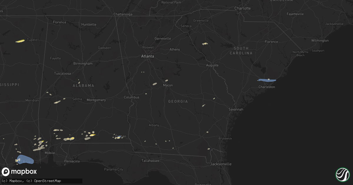
Hail Map in Georgia on June 9, 2025
Get this storm
June 9 map
$229
one time, instant access
Download today. No call, no setup
Keep the $229
Bought the map and want the full workflow? Apply the entire $229 to a subscription within 7 days. None of it is wasted.
Every map, not just this one
This buys you this map. Subscription and you get every map we run, in the markets you choose from a few cities to whole states to nationwide. Plus real-time alerts the moment a storm fires.
Contact data
Name, contact info, occupancy, even credit band for addresses in the footprint. You go from where it hit to who to call.
Become the source they trust
Unlimited branding weather history reports on demand. You already have the documented answer ready for the property owner, and you are the one who showed up with it.
Property data and RoofTrace estimates
Pull up any address you have got, its value and the exact code rules for that jurisdiction, straight from One Click Code. Then RoofTrace estimates the squares, pitch, and roof value, priced the way you price.
Storm reports in Georgia
Georgia
| Date | Description |
|---|---|
| 06/09/20256:10 PM CDT | Multiple trees down on road. |
| 06/09/20253:06 PM CDT | 911 dispatch reported tree down on lake church road. |
| 06/09/20253:05 PM CDT | 911 dispatch reported tree down on dutch ford road. |
| 06/09/20252:38 PM CDT | The worth county 911 call center reported a tree down along douthit road. Timing estimated by radar. |
| 06/09/20252:30 PM CDT | Thunderstorm winds blew apart a portion of the brick facade on the north-facing side of a church building in the 3500 block of sylvester highway. |
| 06/09/20252:28 PM CDT | The worth county 911 call center reported a tree down along woodcrest road. Timing estimated by radar. |
| 06/09/20252:25 PM CDT | Dougherty county communications office reported a tree down along the 1400 block of 11th avenue in albany. Time estimated by radar. |
| 06/09/20252:23 PM CDT | Dougherty county communications office reported a tree down along the 4100 block of gillionville road. Time estimated by radar. |
| 06/09/20252:20 PM CDT | Emer. Mngr shared on social media a photo of a downed tree across road. Time estimated based off radar. |
| 06/09/20252:20 PM CDT | Emer. Mngr shared on social media a photo of a downed tree across road. Time estimated based |
| 06/09/20252:19 PM CDT | Mitchell county 911 call center reports a tree down along old georgia hwy 3. Timing estimated by radar. |
| 06/09/20252:05 PM CDT | Multiple reports of downed trees and powerlines in the folkston area. Some fires started with the downed powerlines. Time based off radar. |
| 06/09/20251:55 PM CDT | Delayed report. Multiple trees and powerlines down... Time estimated from radar... Location approximate. |
| 06/09/20251:55 PM CDT | Delayed report. Large tree down and two powerlines down. Time estimated from radar. |
| 06/09/202512:45 PM CDT | University of georgia mesonet site at sparks. |
| 06/09/202512:32 PM CDT | 911 call center reported a tree down at quarterman rd and hambrick rd. |
| 06/09/202512:18 PM CDT | Brooks county 911 call center reported a tree down along shelly road. Timing estimated by radar. |
| 06/09/202512:16 PM CDT | Thomas county 911 call center reported a tree down near the intersection of ione road and woodhaven road near the brooks-thomas county line. Timing estimated by radar. |
| 06/09/202512:10 PM CDT | Thomas county 911 call center reported a tree down near the intersection of patten-coolidge road and ponder road. Timing estimated by radar. |
| 06/09/202512:03 PM CDT | Thomas county 911 call center reported a tree down near the intersection of hwy 202 and lillie lane. Timing estimated by radar. |
| 06/09/202512:02 PM CDT | Thomas county 911 call center reported a tree down near the intersection of us hwy 19 and hebron lane. Timing estimated by radar. |
| 06/09/202511:44 AM CDT | Thomas county 911 call center reported a tree down near the intersection of maddox road and malloy road. Timing estimated by radar. |
| 06/09/20255:35 AM CDT | Delayed report - ema reported damage to an unfinished mobile home near the 3000 block of old axson road. Mobile home was turned over from straight line winds. Time of d |
| 06/09/20255:35 AM CDT | Delayed report - ema reported damage to an unfi |
| 06/09/20255:35 AM CDT | Delayed report - ema repo |
| 06/09/20255:20 AM CDT | Tree down on woodward stone rd... Time estimated from radar. |
| 06/09/20255:20 AM CDT | Tree down on sinkhole road... Time estimated from radar. |
| 06/09/20255:10 AM CDT | Tree reported down on hwy 64 near ray city. |
| 06/09/20254:00 AM CDT | A cable line and a large tree limb blew down along 5th avenue southeast via th |
| 06/09/20254:00 AM CDT | A cable line and a large tree limb blew down along 5th avenue sou |
| 06/09/20254:00 AM CDT | A cable line and a large tree limb blew down along 5th avenue southeast via the colquitt county scanner. |
All States Impacted by Hail Map on June 9, 2025
Cities Impacted by Hail Map on June 9, 2025
- Hermleigh, TX
- Snyder, TX
- Randolph, AL
- Roscoe, TX
- Loraine, TX
- Brierfield, AL
- Sweetwater, TX
- Nolan, TX
- Blackwell, TX
- Tuscola, TX
- Wingate, TX
- Ovalo, TX
- Winters, TX
- Talpa, TX
- Ballinger, TX
- Patterson, GA
- Blackshear, GA
- Ochlocknee, GA
- Moultrie, GA
- Hartford, AL
- Dothan, AL
- Slocomb, AL
- Valdosta, GA
- Quitman, GA
- Adel, GA
- Jackson, AL
- Pavo, GA
- Gainestown, AL
- Weston, CO
- Frisco City, AL
- Uriah, AL
- Williston, TN
- Moscow, TN
- Bainbridge, GA
- Somerville, TN
- Rickman, TN
- Cookeville, TN
- Folkston, GA
- Livingston, TN
- Kewadin, MI
- Ellsworth, MI
- Harbor Springs, MI
- Howard, CO
- Evergreen, AL
- Tererro, NM
- Lyons, GA
- Cotopaxi, CO
- Ocate, NM
- Levering, MI
- Pellston, MI
- Castleberry, AL
- Santa Fe, NM
- Carp Lake, MI
- Pleasantville, PA
- Oil City, PA
- Andalusia, AL
- Red Level, AL
- Tierra Amarilla, NM
- Mackinaw City, MI
- Bonifay, FL
- State Line, MS
- Leakesville, MS
- Brewton, AL
- Mountainair, NM
- Sugar Grove, PA
- Panama, NY
- Bear Lake, PA
- Ashville, NY
- Columbus, PA
- Register, GA
- Metter, GA
- Arroyo Hondo, NM
- Indian River, MI
- Westville, FL
- Statesboro, GA
- Jamestown, NY
- Raton, NM
- Cheboygan, MI
- Lakewood, NY
- Pittsfield, PA
- Cripple Creek, CO
- Kinross, MI
- Callensburg, PA
- Emlenton, PA
- Sligo, PA
- Parker, PA
- Leeper, PA
- Lucinda, PA
- Kennedy, NY
- Falconer, NY
- Frewsburg, NY
- Des Moines, NM
- Flomaton, AL
- Eckerman, MI
- Rimersburg, PA
- Johannesburg, MI
- Florissant, CO
- Gaylord, MI
- Karns City, PA
- East Brady, PA
- Fort Meade, FL
- Estancia, NM
- Torreon, NM
- Marienville, PA
- Vowinckel, PA
- Vinegar Bend, AL
- Randolph, NY
- New Bethlehem, PA
- Clarion, PA
- Summerville, PA
- Strattanville, PA
- Corsica, PA
- Haines City, FL
- Huger, SC
- Atmore, AL
- Magdalena, NM
- Grenville, NM
- Shippenville, PA
- Knox, PA
- Little River, AL
- Citronelle, AL
- Chunchula, AL
- Hastings, MI
- Summerville, SC
- Ladson, SC
- Goose Creek, SC
- Charleston, SC
- Hanahan, SC
- Awendaw, SC
- Tijeras, NM
- Sigel, PA
- Brookville, PA
- Great Valley, NY
- Freeport, MI
- Lake Odessa, MI
- Winter Haven, FL
- Cerrillos, NM
- Ona, WV
- Atlanta, MI
- Salida, CO
- Cuba, NM
- Jemez Springs, NM
- Marianna, FL
- Edgewood, NM
- Newton, AL
- Malone, FL
- Moriarty, NM
- Humble, TX
- Clarington, PA
- Portland, MI
- Willard, NM
- Houston, TX
- Wilmer, AL
- Lamy, NM
- Moore Haven, FL
- Okeechobee, FL
- Muir, MI
- Pewamo, MI
- Lyons, MI
- Waller, TX
- Hockley, TX
- Claunch, NM
- Tomball, TX
- Cypress, TX
- Saint Helen, MI
- Lucedale, MS
- Cat Spring, TX
- Roscommon, MI
- Grayling, MI
- Ashford, AL
- Columbia, MS
- Sebring, FL
- Bath, NY
- Canisteo, NY
- Cameron, NY
- Ribera, NM
- Sandia Park, NM
- Lewiston, MI
- Sealy, TX
- Stanley, NM
- Anton Chico, NM
- Saraland, AL
- Sweet Water, AL
- Linden, AL
- Santa Rosa, NM
- Kingwood, TX
- Huffman, TX
- Greenwood, SC
- Bradley, SC
- Galeton, PA
- Mayport, PA
- Dayton, TX
- Abbeville, SC
- Magnolia, TX
- Smithville, TX
- Rosanky, TX
- Waelder, TX
- Spring, TX
- Gaines, PA
- Vaughn, NM
- Ringgold, PA
- Timblin, PA
- Punxsutawney, PA
- Galena Park, TX
- Worthville, PA
- Sprankle Mills, PA
- Faunsdale, AL
- Pinehurst, TX
- Conroe, TX
- Savona, NY
- Newkirk, NM
- Cuervo, NM
- Stanton, TX
- Hammondsport, NY
- Uniontown, AL
- Gladstone, NM
- Big Spring, TX
- Garden City, TX
- Bradford, NY
- Dundee, NY
- Watkins Glen, NY
- Beaver Dams, NY
- Roy, NM
- New Caney, TX
- Porter, TX
- Bladenboro, NC
- Clarkton, NC
- Semmes, AL
- Boise City, OK
- Elizabethtown, NC
- Alleyton, TX
- Milesburg, PA
- Bellefonte, PA
- Julian, PA
- Fleming, PA
- Howard, PA
- Hector, NY
- Rock Stream, NY
- Burdett, NY
- Eight Mile, AL
- Splendora, TX
- Old Fields, WV
- Moorefield, WV
- Purgitsville, WV
- Columbus, TX
- Vancourt, TX
- Romney, WV
- Senoia, GA
- Livingston, AL
- Weimar, TX
- Wiggins, MS
- Lumberton, MS
- House, NM
- Glidden, TX
- Rio, WV
- Augusta, WV
- Shanks, WV
- Sterling City, TX
- Trumansburg, NY
- Fort Sumner, NM
- Tucumcari, NM
- Eldorado, TX
- Junction City, GA
- Mauk, GA
- Oxford, MS
- Pontotoc, MS
- Paris, MS
- Randolph, MS
- Huntingdon, PA
- Gray, GA
- Taiban, NM
- Perkinston, MS
- Spring Mills, PA
- Everett, PA
- Hopewell, PA
- Boalsburg, PA
- Centre Hall, PA
- Yeso, NM
- Yatesville, GA
- Somes Bar, CA
- Happy Camp, CA
- Mcalister, NM
- Floyd, NM
- Melrose, NM
- Reedsville, PA
- Delray, WV
- Lawley, AL
- Milroy, PA
- Six Mile Run, PA
- Belleville, PA
- McHenry, MS
- Macon, GA
- Christoval, TX
- Culloden, GA
- Mertzon, TX
- Yeagertown, PA
- Lewistown, PA
- Coburn, PA
- Grady, AR
- Pine Bluff, AR
- Hallettsville, TX
- Schulenburg, TX
- McClure, PA
- Clovis, NM
- Kiln, MS
- Andrews, TX
- Roswell, NM
- Pass Christian, MS
- Gulfport, MS
- Conchas Dam, NM
- Woodward, PA
- Millmont, PA
- Petersburg, PA
- Gunnison, CO
- Orbisonia, PA
- Shirleysburg, PA
- Blairs Mills, PA
- Rockhill Furnace, PA
- Big Lake, TX
- East Waterford, PA
- Eunice, NM
- Mount Union, PA
- McVeytown, PA
- Diberville, MS
- Saucier, MS
- Ocean Springs, MS
- Long Beach, MS
- Biloxi, MS
- Vancleave, MS
- Gautier, MS
- Moss Point, MS
- Ozona, TX
- Seminole, TX
- Flatonia, TX
- Mifflintown, PA
- Mifflin, PA
- Port Royal, PA
- Honey Grove, PA
- Hereford, TX
- Sudan, TX
- Muleshoe, TX
- Adrian, TX
- San Jon, NM
- Broadview, NM
- Bard, NM
- Friona, TX
- Texico, NM
- Farwell, TX
- Portales, NM
- Bovina, TX
- Goldsmith, TX
- Belle Glade, FL
- Earth, TX
- Como, CO
- Tatum, NM
- Odessa, TX
- Sonora, TX
- Hagerman, NM
- Lake George, CO
- Lovington, NM
- Artesia, NM
- Kermit, TX
- Maljamar, NM
- Carlsbad, NM
- Gerry, NY
- Plains, TX
- Burnham, PA
- Templeton, PA
- Three Springs, PA
- Midland, TX
- Marble, PA
- Cranberry, PA
- Hobbs, NM
- Meadow, TX
- Loving, NM
- Shallowater, TX
- Anton, TX
- Levelland, TX
- Tokio, TX
- Brownfield, TX
- Notrees, TX
- Midkiff, TX
- McCamey, TX
- Lubbock, TX
- Idalou, TX
- Jal, NM
- Spur, TX
- Seagraves, TX
- Mentone, TX
- Loop, TX
- Welch, TX
- Lamesa, TX
- Pecos, TX
- Rule, TX
- Stamford, TX
- Cedar Crest, NM
- Odonnell, TX
- Aspermont, TX
- Pyote, TX
- Haskell, TX
- Tarzan, TX
- Neely, MS
- Opp, AL
- Poplarville, MS
- Deer Park, AL
- Diamondhead, MS
- Hamlin, TX
- Lenorah, TX
- Barstow, TX
- Florala, AL
- Monahans, TX
- Imperial, TX
- Westbrook, TX
- Throckmorton, TX
- Coyanosa, TX
- Grandfalls, TX
- Crane, TX
- Rankin, TX
- Barney, GA
- Jayton, TX
- Ira, TX
- Barnhart, TX
- San Angelo, TX
- Valera, TX
- Voss, TX
- Santa Anna, TX
- Coleman, TX
- Cross Plains, TX
- Eden, TX
- Brownwood, TX
- Fort McKavett, TX
- Menard, TX
- Rising Star, TX
- Melvin, TX
- Early, TX
- Junction, TX
- Brady, TX
- May, TX
- Weinert, TX
- Fluvanna, TX
- Rotan, TX


