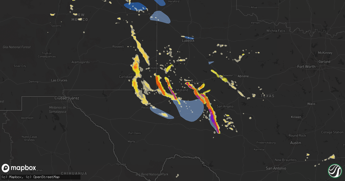
Hail Map on June 9, 2025
Get this storm
June 9 map
$229
one time, instant access
Download today. No call, no setup
Keep the $229
Bought the map and want the full workflow? Apply the entire $229 to a subscription within 7 days. None of it is wasted.
Every map, not just this one
This buys you this map. Subscription and you get every map we run, in the markets you choose from a few cities to whole states to nationwide. Plus real-time alerts the moment a storm fires.
Contact data
Name, contact info, occupancy, even credit band for addresses in the footprint. You go from where it hit to who to call.
Become the source they trust
Unlimited branding weather history reports on demand. You already have the documented answer ready for the property owner, and you are the one who showed up with it.
Property data and RoofTrace estimates
Pull up any address you have got, its value and the exact code rules for that jurisdiction, straight from One Click Code. Then RoofTrace estimates the squares, pitch, and roof value, priced the way you price.
States Impacted by Hail Map on June 9, 2025
Storm reports
Pennsylvania
| Date | Description |
|---|---|
| 06/09/20256:23 PM CDT | Numerous trees down along cemetery hill road and laurel ridge road. |
| 06/09/20256:15 PM CDT | Tree down across the roadway on bellemeade drive near linwood road. |
| 06/09/20256:15 PM CDT | Trees and wires down blocking a roadway near 22nd street and logan avenue. |
| 06/09/20256:05 PM CDT | Picture on facebook page |
| 06/09/20255:58 PM CDT | Tree down on us 322 near spencer ln. |
| 06/09/20255:29 PM CDT | Tree down over the road with lines blocking the |
| 06/09/20255:29 PM CDT | Tree down over the road with lines blocking the roadway. |
| 06/09/20254:52 PM CDT | Several barns and numerous trees damaged in the area. Possible tornado damage. |
| 06/09/20254:49 PM CDT | An ef-2 tornado tracked northeast across knowle road. The tornado destroyed two barns and damaged the siding and wind |
| 06/09/20254:45 PM CDT | Time estimated by radar. Tree down over the road with power li |
| 06/09/20254:45 PM CDT | Time estimated by radar. Tree down over the road with power lines blocking the roadway on route 949. Possible tornado. |
| 06/09/20254:43 PM CDT | Corrects time of previous tstm wnd dmg report from 1 ese sigel. Tree down over the road with lines blocking the roadway. |
| 06/09/20254:31 PM CDT | Tree down along route 322 just west of exit 70 on i-80. |
| 06/09/20254:29 PM CDT | Trees uprooted along brush run rd. Possible tornado. |
| 06/09/20254:29 PM CDT | Large limbs down near mile marker 67 along i-80. Possible tornado. |
| 06/09/20254:27 PM CDT | Corrected time. Ef-0 tornado confirmed just north of limestone. |
| 06/09/20254:26 PM CDT | Ef-0 tornado confirmed just north of limestone. |
| 06/09/20254:24 PM CDT | Trees down in the town of limestone. Time estimated via radar. |
| 06/09/20254:10 PM CDT | Picture of hail next to ruler sent from em near sligo... Pa. |
| 06/09/20253:41 PM CDT | Tree down near the intersection of sutton road and route 958. |
| 06/09/20253:09 PM CDT | Multiple trees down onto houses in columbus township. |
| 06/09/20253:02 PM CDT | Minor roof damage to a barn and tree damage. |
| 06/09/20252:46 PM CDT | Numerous trees downed in and around canadohta lake. |
| 06/09/20252:46 PM CDT | Local public safety scanner reported a tree down on payne avenue. Time estimated via radar. |
| 06/09/20252:45 PM CDT | County public safety scanner reported a tree down on wires on lake road. Time estimated via radar. |
| 06/09/20252:45 PM CDT | The national weather service in cleveland confirmed an ef0 tornado in the canadohta lake area. Large tree limbs from a nearby tree were blown onto a home... Resulting i |
| 06/08/202510:10 PM CDT | Two trees fell on a house and into a bedroom. |
| 06/08/20258:28 PM CDT | Multiple reports of quarter sized hail at the rutters in milroy. |
| 06/08/20258:27 PM CDT | A local report indicates 1.25 inch wind near Reedsville |
| 06/08/20258:05 PM CDT | Tree and wires down on greenwood road. |
| 06/08/20257:46 PM CDT | Trees and wires down on hartslog valley road near the intersection of blue moon road. |
| 06/08/20257:41 PM CDT | Trees and wires down on summit school road. |
| 06/08/20257:40 PM CDT | Trees and wires down onto wesley chapel road. |
| 06/08/20257:20 PM CDT | Multiple trees and wires down in the milesburg area. |
Texas
| Date | Description |
|---|---|
| 06/09/20256:55 PM CDT | A local report indicates 1.50 inch wind near 3 S Forsan |
| 06/09/20256:46 PM CDT | [landspout] an off-duty nws employee and another chaser reported two landspouts that lasted for about seven minutes. |
| 06/09/20256:46 PM CDT | [landspout] an off |
| 06/09/20256:46 PM CDT | [l |
| 06/09/20256:20 PM CDT | Spotter reports quarter inch hail in the woodlands. |
| 06/09/20256:20 PM CDT | Report from mping: quarter |
| 06/09/20254:19 AM CDT | Report from observer in mccamey with personal anemometer. |
| 06/09/20253:31 AM CDT | Mesonet station 55 5sw st. Lawrence... Tx. |
| 06/09/20253:23 AM CDT | Mesonet station 63 2n coyanosa. |
| 06/09/20253:01 AM CDT | Mesonet station gw6198 midland. |
| 06/09/20253:00 AM CDT | Mesonet station fw9685 odessa. |
| 06/09/20252:59 AM CDT | Mesonet station 37 snyder 3e. |
| 06/09/20252:53 AM CDT | Asos station kmaf midland. |
| 06/09/20252:24 AM CDT | Corrects previous hail report from haskell. |
| 06/09/20252:23 AM CDT | Nws employee reports gusts near 60 mph in gardendale. |
| 06/09/202512:29 AM CDT | Mesonet station 15 seagraves 1sw. |
| 06/09/202512:18 AM CDT | A local report indicates 58 MPH wind near 1 NNW Lubbock Int. Airp |
| 06/09/202512:13 AM CDT | Delayed report from media viewer. Hail at least one inch. Time and |
| 06/09/202512:13 AM CDT | Delayed report from media viewer. Hail at least one inch. Time and size estimated. |
| 06/08/202511:51 PM CDT | Report from mping: golf ball |
| 06/08/202511:30 PM CDT | Nws employee reports approximately quarter size hail near 42nd street and dixie blvd. ( |
| 06/08/202511:30 PM CDT | Nws employee reports approximately quarter size hail near 42nd street and dixie blvd. |
| 06/08/202511:28 PM CDT | Report from mping: half dollar |
| 06/08/202511:28 PM CDT | Broadcast media shared report of half-dollar size hail and a bit larger in western portions of odessa. |
| 06/08/202511:25 PM CDT | Report from mping: half dollar |
| 06/08/202511:17 PM CDT | Trained spotter reported quarter size hail in odessa. |
| 06/08/202511:06 PM CDT | Report from mping: ping pong ball |
| 06/08/202511:03 PM CDT | Report from mping: quarter |
| 06/08/202511:00 PM CDT | Report from mping: quarter |
| 06/08/202510:13 PM CDT | Second peak severe gust to 58 mph from line of storms after the initial line moved through. |
| 06/08/202510:03 PM CDT | A local report indicates 60 MPH wind near 11 WNW Bootleg |
| 06/08/20259:12 PM CDT | An off duty nws employee measured hail stones of 3.25 inches. A local resident reported even larger hail with at least 25 pickup trucks and larger trucks that had windo |
| 06/08/20258:45 PM CDT | A local report indicates 1.50 inch wind near Garden City |
| 06/08/20258:34 PM CDT | A local report indicates 1.00 inch wind near 3 S Garden City |
| 06/08/20257:40 PM CDT | Multiple pictures on social media of tennis ball size hail. Time estimated by radar. |
| 06/08/20257:35 PM CDT | Time estimated by radar. |
| 06/08/20257:30 PM CDT | Time estimated from radar. |
| 06/08/20257:02 PM CDT | Time estimated by radar. |
| 06/08/20257:00 PM CDT | An off duty nws employee reported hen egg size hail. Time estimated by radar. |
Florida
| Date | Description |
|---|---|
| 06/09/20251:52 PM CDT | Debris on powerlines near the intersection of marion ave and miccosukee road. |
| 06/09/202511:45 AM CDT | The jefferson county sherrif office reported a line of trees down along cocroft road in the northern part of the county. Timing estimated by radar. |
| 06/09/20253:52 AM CDT | A tree blew down and partially blocked cherry tree road. |
| 06/09/20253:22 AM CDT | An object blew into power lines... Resulting in a power outage to 250 customers in the sopchoppy area. |
| 06/09/20253:20 AM CDT | A tree blew over on to a house in crawfordville. Additional multiple trees were blown down in crawfordville. |
| 06/09/20252:45 AM CDT | A tree blew down and blocked the outside travel lane of blue star highway... U.s. 90. |
| 06/09/20252:36 AM CDT | Tree down on i-10 near mile markers 162-163. Fhp on scene. |
| 06/09/20252:23 AM CDT | A tree blew down and created a roadway obstruction on bainbridge highway. |
| 06/09/20252:23 AM CDT | A tree blew down and obstructed travel on dewey johnson way. |
| 06/09/20251:57 AM CDT | Power line blown down near intersection of spring street and nw baker street. |
| 06/09/20251:56 AM CDT | Tree reported down in the area. |
| 06/09/20251:55 AM CDT | A tree blew down and obstructed nw martin l king rd. |
Mississippi
| Date | Description |
|---|---|
| 06/08/20259:42 PM CDT | Asos station kgpt gulfport-biloxi intl airport. |
| 06/08/20259:23 PM CDT | Asos station kgpt gulfport-biloxi intl airport. |
| 06/08/20259:02 PM CDT | A tree was downed near south swan rd and swan lane. Time estimated by radar. |
| 06/08/20258:23 PM CDT | Quarter sized hail at the corner of hwy 6 and hwy 9. |
| 06/08/20257:59 PM CDT | A local report indicates 1.00 inch wind near Randolph |
North Carolina
| Date | Description |
|---|---|
| 06/09/20255:15 PM CDT | Tree snapped and fell on car in white oak. Time via radar. Wind speeds estimated around 40-50mph based on pictures of tree. |
| 06/09/20255:30 AM CDT | Report came in from big rock landing t |
| 06/09/20255:30 AM CDT | Report came in from big rock landing that multiple temporary structures were d |
| 06/09/20255:30 AM CDT | Report came in from big rock landing that multiple temporary structures were damaged when line of storms came through. A few smaller pop up tents and a larger awning st |
| 06/09/20255:30 AM CDT | Report came in from big rock landing that multiple temporary structures were damaged |
Alabama
| Date | Description |
|---|---|
| 06/09/20255:54 PM CDT | Broadcast media reports a large oak tree ontop of a home and pickup truck on gordon lane in brewton alabama. Time estimated by radar and report via social media. |
| 06/09/20255:29 PM CDT | Member of the public reported quarter-size hail on the south side of dothan. |
| 06/09/20255:25 PM CDT | Reports of a tree down near ridgeview drive and south park avenue. Timing estimated by radar. |
| 06/09/20254:40 PM CDT | Media relayed public report of quarter sized hail south of citronelle. Time estimated via radar. |
| 06/09/20253:35 PM CDT | Public reports ping pong ball sized hail just south of andalusia... Al. |
| 06/09/20251:35 PM CDT | Mesonet station |
| 06/09/202512:40 PM CDT | A tree fell on hodgesville road near ross clark circle. |
| 06/09/202512:40 PM CDT | Corrects previous tstm wnd gst report from 2 ese green acres. Mesonet station |
| 06/08/20257:40 PM CDT | Coffee county 911 center reports a tree down along hwy 167 near hwy 51. |
Kentucky
| Date | Description |
|---|---|
| 06/09/20253:00 PM CDT | Tree down across the roadway. Time estimated by radar. |
| 06/09/20252:54 PM CDT | Trees fallen completely over the roadway. Time estimated by radar. |
| 06/09/20252:22 PM CDT | Jackson county dispatch reported a tree down on the 700 block of green hill welchburg road. Time estimated from radar. |
| 06/09/20252:22 PM CDT | Jackson county dispatch reported a tree down near the intersection of us 421 and ky-30 in tyner... Ky. Time estimated from radar. |
| 06/09/20252:16 PM CDT | Jackson county dispatch reported a tree down near the intersection of hazel branch and anna moore rd. In annville... Ky. Time estimated from radar. |
| 06/09/20252:09 PM CDT | Jackson county dispatch reported a tree down on the 5800 block of ky-3630 in annville... Ky. Time estimated from radar. |
| 06/09/20252:09 PM CDT | Jackson county dispatch reported a tree down on the 5700 block of ky-577 in annville... Ky. Time estimated from radar. |
Georgia
| Date | Description |
|---|---|
| 06/09/20256:10 PM CDT | Multiple trees down on road. |
| 06/09/20253:06 PM CDT | 911 dispatch reported tree down on lake church road. |
| 06/09/20253:05 PM CDT | 911 dispatch reported tree down on dutch ford road. |
| 06/09/20252:38 PM CDT | The worth county 911 call center reported a tree down along douthit road. Timing estimated by radar. |
| 06/09/20252:30 PM CDT | Thunderstorm winds blew apart a portion of the brick facade on the north-facing side of a church building in the 3500 block of sylvester highway. |
| 06/09/20252:28 PM CDT | The worth county 911 call center reported a tree down along woodcrest road. Timing estimated by radar. |
| 06/09/20252:25 PM CDT | Dougherty county communications office reported a tree down along the 1400 block of 11th avenue in albany. Time estimated by radar. |
| 06/09/20252:23 PM CDT | Dougherty county communications office reported a tree down along the 4100 block of gillionville road. Time estimated by radar. |
| 06/09/20252:20 PM CDT | Emer. Mngr shared on social media a photo of a downed tree across road. Time estimated based off radar. |
| 06/09/20252:20 PM CDT | Emer. Mngr shared on social media a photo of a downed tree across road. Time estimated based |
| 06/09/20252:19 PM CDT | Mitchell county 911 call center reports a tree down along old georgia hwy 3. Timing estimated by radar. |
| 06/09/20252:05 PM CDT | Multiple reports of downed trees and powerlines in the folkston area. Some fires started with the downed powerlines. Time based off radar. |
| 06/09/20251:55 PM CDT | Delayed report. Multiple trees and powerlines down... Time estimated from radar... Location approximate. |
| 06/09/20251:55 PM CDT | Delayed report. Large tree down and two powerlines down. Time estimated from radar. |
| 06/09/202512:45 PM CDT | University of georgia mesonet site at sparks. |
| 06/09/202512:32 PM CDT | 911 call center reported a tree down at quarterman rd and hambrick rd. |
| 06/09/202512:18 PM CDT | Brooks county 911 call center reported a tree down along shelly road. Timing estimated by radar. |
| 06/09/202512:16 PM CDT | Thomas county 911 call center reported a tree down near the intersection of ione road and woodhaven road near the brooks-thomas county line. Timing estimated by radar. |
| 06/09/202512:10 PM CDT | Thomas county 911 call center reported a tree down near the intersection of patten-coolidge road and ponder road. Timing estimated by radar. |
| 06/09/202512:03 PM CDT | Thomas county 911 call center reported a tree down near the intersection of hwy 202 and lillie lane. Timing estimated by radar. |
| 06/09/202512:02 PM CDT | Thomas county 911 call center reported a tree down near the intersection of us hwy 19 and hebron lane. Timing estimated by radar. |
| 06/09/202511:44 AM CDT | Thomas county 911 call center reported a tree down near the intersection of maddox road and malloy road. Timing estimated by radar. |
| 06/09/20255:35 AM CDT | Delayed report - ema reported damage to an unfi |
| 06/09/20255:35 AM CDT | Delayed report - ema repo |
| 06/09/20255:35 AM CDT | Delayed report - ema reported damage to an unfinished mobile home near the 3000 block of old axson road. Mobile home was turned over from straight line winds. Time of d |
| 06/09/20255:20 AM CDT | Tree down on woodward stone rd... Time estimated from radar. |
| 06/09/20255:20 AM CDT | Tree down on sinkhole road... Time estimated from radar. |
| 06/09/20255:10 AM CDT | Tree reported down on hwy 64 near ray city. |
| 06/09/20254:00 AM CDT | A cable line and a large tree limb blew down along 5th avenue sou |
| 06/09/20254:00 AM CDT | A cable line and a large tree limb blew down along 5th avenue southeast via the colquitt county scanner. |
| 06/09/20254:00 AM CDT | A cable line and a large tree limb blew down along 5th avenue southeast via th |
Ohio
| Date | Description |
|---|---|
| 06/09/20254:28 PM CDT | This is the start point of a tornado with peak intensity of ef1 with estimated peak winds of 105 mph. Damage path length is 1.32 miles and maximum width is 80 yards. |
| 06/09/20254:26 PM CDT | Several trees and power lines down with about five houses with trees on them. Possible tornado damage. |
| 06/09/20253:59 PM CDT | Tree on powerlines causing power outages. Time estimated by radar. |
| 06/09/20253:24 PM CDT | Tree down in the roadway between twp rd 310 & twp rd 290. |
| 06/09/20252:54 PM CDT | Multiple trees blocking road at bridge road and dugan road. Time estimated by radar. |
| 06/09/20252:36 PM CDT | Tree down on power lines. |
| 06/09/20252:10 PM CDT | A couple of trees down in the rosemount area. Time estimated from radar. |
| 06/09/20252:06 PM CDT | Tree down in mcdermott area. Time estimated from radar. |
| 06/09/20252:03 PM CDT | Tree down in west portsmouth. Time estimated from radar. |
| 06/09/20251:27 PM CDT | Tree down along carbon hill buchtel road. Time estimated from radar. |
| 06/09/20251:22 PM CDT | Tree down along stagecoach road. |
South Carolina
| Date | Description |
|---|---|
| 06/09/20256:38 PM CDT | Mccormick county dispatch reported trees down at the intersection of us 221 and eden hall rd. Time estimated by radar. |
| 06/09/20256:38 PM CDT | Mccormick county dispatch reported trees |
| 06/09/20256:38 PM CDT | Mccormick county dispatch reported trees d |
| 06/09/20256:25 PM CDT | Mccormick county dispatch reported trees down along hwy 28 north. Time estimated based on radar. |
| 06/09/20256:06 PM CDT | Trees down on powerlines. |
| 06/09/20255:55 PM CDT | Public reported two large trees down. |
| 06/09/20255:45 PM CDT | Multiple trees down in aynor... With one report of roof damage via social media. |
| 06/09/20254:26 PM CDT | Emergency manager reported tree down blocking roadway near intersection of hwy 41 and french quarter creek rd. |
| 06/09/20254:26 PM CDT | Emergency manager reported tree down blocking roadway |
| 06/09/20254:09 PM CDT | Spotter reported fascia blew off at roof line of house. |
| 06/09/20254:07 PM CDT | Emergency manager reported tree down blocking roadway near intersection of hwy 52 and old mount holly rd. Time was estimated via radar data. |
| 06/09/20254:05 PM CDT | Dorchester emergency manager reports multiple trees down across downtown summerville. |
| 06/09/20254:01 PM CDT | Media relayed a picture of a residential home with siding damage near the intersection of fairfax blvd and hwy 176. Time was estimated via radar data. |
| 06/09/202511:48 AM CDT | Possible tornado...tds from kcae. Time of the tds appearing on radar. |
| 06/08/20258:37 PM CDT | Scdps website reports a tree in roadway on busbee road. Time estimated by radar. |
| 06/08/20258:12 PM CDT | Scdps website and richland county em reported a tree on the roadway on lorick road near dozier lane. |
| 06/08/20258:10 PM CDT | Corrects previous tstm wnd dmg report from 6 sw blythewood. Columbia fire dept reported a tree down blocking the roadway at the intersection of lorick rd and winnsboro |
| 06/08/20258:02 PM CDT | Columbia fire dept reported a tree down blocking the roadway at the intersection of lorick rd and winnsboro rd. Time estimated by radar. |
| 06/08/20257:53 PM CDT | Columbia fire reports a tree down on a house as well as a powerline down. Time estimated based on radar. |
| 06/08/20257:48 PM CDT | Columbia news affiliate posted a picture from a viewer in chapin of a large branch snapped off a tree. Time estimated by radar. |
| 06/08/20257:44 PM CDT | Newberry county dispatch reported a tree down along sam koon rd near maple hollow ln. Time estimated by radar. |
| 06/08/20257:42 PM CDT | Newberry county dispatch reported trees down along hwy 176 near mayer rd. Time estimated by radar. |
| 06/08/20257:21 PM CDT | Saluda county dispatch reported trees down on powerlines in the 4000 block of newberry highway north of saluda. Time estimated by radar. |
| 06/08/20257:18 PM CDT | Saluda county dispatch reported trees down at the ridge rd and caldwell rd. Time estimated by radar. |
| 06/08/20257:15 PM CDT | Trained weather spotter reported tree down on a powerline in the 6500-6800 block of sc 121. Time estimated by radar. |
West Virginia
| Date | Description |
|---|---|
| 06/09/20254:00 PM CDT | Tree down at gamms hill road. Time estimated by radar. |
| 06/09/20253:18 PM CDT | Tree down blocking one lane of the road at pike st and stephens st. |
| 06/08/20257:18 PM CDT | Tree downed across roadway near cumberland rd. And goldsborough rd. |
New York
| Date | Description |
|---|---|
| 06/09/20256:35 PM CDT | A local report indicates 1.00 inch wind near Bath |
| 06/09/20256:02 PM CDT | Tree down on house... Damaging the roof over the porch and breaking a window. |
| 06/09/20255:46 PM CDT | Large tree uprooted in yard and onto dog kennel. |
| 06/09/20254:37 PM CDT | Nws storm survey confirmed damage consistent with an ef-1 tornado with maximum winds of 110 mph. |
| 06/09/20254:04 PM CDT | *delayed report* several trees down in steamburg... Including tree on a house. Marble sized hail. |
| 06/09/20253:49 PM CDT | A local report indicates 1.00 inch wind near Jamestown |
| 06/09/20253:42 PM CDT | Tree down in kiantone. |
| 06/09/20253:38 PM CDT | Several trees and wires down in sandy creek. |
| 06/09/20253:37 PM CDT | A local report indicates 1.00 inch wind near Jamestown |
| 06/09/20253:37 PM CDT | A local report indicates 1.25 inch wind near Jamestown |
| 06/09/20253:32 PM CDT | Trees and wires down in town. |
| 06/09/20253:30 PM CDT | Corrects previous hail report from jamestown. |
| 06/09/20253:30 PM CDT | Tree down blocking roadway. |
| 06/09/20253:30 PM CDT | A local report indicates 1.00 inch wind near 3 S Jamestown West |
| 06/08/20258:12 PM CDT | Multiple trees uprooted or snapped. |
| 06/08/20258:10 PM CDT | A few trees down around town. |
| 06/08/20257:39 PM CDT | Tree and wires down on the road. |
| 06/08/20257:38 PM CDT | One tree uprooted... Large branches snapped. |
| 06/08/20257:35 PM CDT | Tree down on road. |
| 06/08/20257:34 PM CDT | Tree down on road. |
| 06/08/20257:34 PM CDT | Tree fell on building. |
| 06/08/20257:10 PM CDT | Phillips hill road closed due to flooding. |
| 06/08/20257:10 PM CDT | Corrects previous the time of the tstm wnd dmg report from reading center. A few trees down around town. |
Michigan
| Date | Description |
|---|---|
| 06/09/20254:44 PM CDT | Large portion of a slightly rotten tree broken onto power lines on shoreline drive... South of custer rd. |
| 06/09/20253:59 PM CDT | Tree down near 15 mile & ritchie. Time estimated via radar. Delayed report. |
| 06/09/20253:23 PM CDT | Tree down over red arrow hwy at m51. Time estimated via radar. Delayed report. |
New Mexico
| Date | Description |
|---|---|
| 06/09/20255:50 PM CDT | Large broken tree limbs in roosevelt park from strong winds. |
| 06/09/20255:30 PM CDT | Hail size ranged from half inch to half dollar size. |
| 06/09/20255:30 PM CDT | A local report indicates 1.00 inch wind near Sandia Park |
| 06/09/20255:30 PM CDT | A local report indicates 2.50 inch wind near Moriarty |
| 06/09/20255:25 PM CDT | Hail size ranged from 1/2 inch to half dollar size. |
| 06/09/20255:20 PM CDT | A local report indicates 1.00 inch wind near Sandia Park |
| 06/09/20255:10 PM CDT | Report from mping: half dollar |
| 06/09/20255:00 PM CDT | Golf ball size hail shattered rain gauge and resulted in house and vehicle damage as well. |
| 06/09/20254:45 PM CDT | Hail storm from 1545 to 1605 with damage. Tree... House and auto damage. Hail size ranged from golf ball to baseball size. |
| 06/09/20251:00 AM CDT | Mesonet station fw9688 jal. |
| 06/09/202512:02 AM CDT | Mesonet station nmc36 malaga. Time estimated by radar. |
| 06/08/20258:25 PM CDT | A local report indicates 60 MPH wind near Taiban |
| 06/08/20258:25 PM CDT | Spotter reports broken tree branches of about 5 inches in diameter from trees around her house. |
| 06/08/20258:20 PM CDT | Trained spotter in house in southern quay county reports an estimated wind speed of 65 mph and small broken tree limbs and branches. |
| 06/08/20257:10 PM CDT | Quarter size hail being reported along i-40 near newkirk. Heavy hail accumulations are covering the roadways. |
Cities Impacted by Hail Map on June 9, 2025
- Hermleigh, TX
- Snyder, TX
- Randolph, AL
- Roscoe, TX
- Loraine, TX
- Brierfield, AL
- Sweetwater, TX
- Nolan, TX
- Blackwell, TX
- Tuscola, TX
- Wingate, TX
- Ovalo, TX
- Winters, TX
- Talpa, TX
- Ballinger, TX
- Patterson, GA
- Blackshear, GA
- Ochlocknee, GA
- Moultrie, GA
- Hartford, AL
- Dothan, AL
- Slocomb, AL
- Valdosta, GA
- Quitman, GA
- Adel, GA
- Jackson, AL
- Pavo, GA
- Gainestown, AL
- Weston, CO
- Frisco City, AL
- Uriah, AL
- Williston, TN
- Moscow, TN
- Bainbridge, GA
- Somerville, TN
- Rickman, TN
- Cookeville, TN
- Folkston, GA
- Livingston, TN
- Kewadin, MI
- Ellsworth, MI
- Harbor Springs, MI
- Howard, CO
- Evergreen, AL
- Tererro, NM
- Lyons, GA
- Cotopaxi, CO
- Ocate, NM
- Levering, MI
- Pellston, MI
- Castleberry, AL
- Santa Fe, NM
- Carp Lake, MI
- Pleasantville, PA
- Oil City, PA
- Andalusia, AL
- Red Level, AL
- Tierra Amarilla, NM
- Mackinaw City, MI
- Bonifay, FL
- State Line, MS
- Leakesville, MS
- Brewton, AL
- Mountainair, NM
- Sugar Grove, PA
- Panama, NY
- Bear Lake, PA
- Ashville, NY
- Columbus, PA
- Register, GA
- Metter, GA
- Arroyo Hondo, NM
- Indian River, MI
- Westville, FL
- Statesboro, GA
- Jamestown, NY
- Raton, NM
- Cheboygan, MI
- Lakewood, NY
- Pittsfield, PA
- Cripple Creek, CO
- Kinross, MI
- Callensburg, PA
- Emlenton, PA
- Sligo, PA
- Parker, PA
- Leeper, PA
- Lucinda, PA
- Kennedy, NY
- Falconer, NY
- Frewsburg, NY
- Des Moines, NM
- Flomaton, AL
- Eckerman, MI
- Rimersburg, PA
- Johannesburg, MI
- Florissant, CO
- Gaylord, MI
- Karns City, PA
- East Brady, PA
- Fort Meade, FL
- Estancia, NM
- Torreon, NM
- Marienville, PA
- Vowinckel, PA
- Vinegar Bend, AL
- Randolph, NY
- New Bethlehem, PA
- Clarion, PA
- Summerville, PA
- Strattanville, PA
- Corsica, PA
- Haines City, FL
- Huger, SC
- Atmore, AL
- Magdalena, NM
- Grenville, NM
- Shippenville, PA
- Knox, PA
- Little River, AL
- Citronelle, AL
- Chunchula, AL
- Hastings, MI
- Summerville, SC
- Ladson, SC
- Goose Creek, SC
- Charleston, SC
- Hanahan, SC
- Awendaw, SC
- Tijeras, NM
- Sigel, PA
- Brookville, PA
- Great Valley, NY
- Freeport, MI
- Lake Odessa, MI
- Winter Haven, FL
- Cerrillos, NM
- Ona, WV
- Atlanta, MI
- Salida, CO
- Cuba, NM
- Jemez Springs, NM
- Marianna, FL
- Edgewood, NM
- Newton, AL
- Malone, FL
- Moriarty, NM
- Humble, TX
- Clarington, PA
- Portland, MI
- Willard, NM
- Houston, TX
- Wilmer, AL
- Lamy, NM
- Moore Haven, FL
- Okeechobee, FL
- Muir, MI
- Pewamo, MI
- Lyons, MI
- Waller, TX
- Hockley, TX
- Claunch, NM
- Tomball, TX
- Cypress, TX
- Saint Helen, MI
- Lucedale, MS
- Cat Spring, TX
- Roscommon, MI
- Grayling, MI
- Ashford, AL
- Columbia, MS
- Sebring, FL
- Bath, NY
- Canisteo, NY
- Cameron, NY
- Ribera, NM
- Sandia Park, NM
- Lewiston, MI
- Sealy, TX
- Stanley, NM
- Anton Chico, NM
- Saraland, AL
- Sweet Water, AL
- Linden, AL
- Santa Rosa, NM
- Kingwood, TX
- Huffman, TX
- Greenwood, SC
- Bradley, SC
- Galeton, PA
- Mayport, PA
- Dayton, TX
- Abbeville, SC
- Magnolia, TX
- Smithville, TX
- Rosanky, TX
- Waelder, TX
- Spring, TX
- Gaines, PA
- Vaughn, NM
- Ringgold, PA
- Timblin, PA
- Punxsutawney, PA
- Galena Park, TX
- Worthville, PA
- Sprankle Mills, PA
- Faunsdale, AL
- Pinehurst, TX
- Conroe, TX
- Savona, NY
- Newkirk, NM
- Cuervo, NM
- Stanton, TX
- Hammondsport, NY
- Uniontown, AL
- Gladstone, NM
- Big Spring, TX
- Garden City, TX
- Bradford, NY
- Dundee, NY
- Watkins Glen, NY
- Beaver Dams, NY
- Roy, NM
- New Caney, TX
- Porter, TX
- Bladenboro, NC
- Clarkton, NC
- Semmes, AL
- Boise City, OK
- Elizabethtown, NC
- Alleyton, TX
- Milesburg, PA
- Bellefonte, PA
- Julian, PA
- Fleming, PA
- Howard, PA
- Hector, NY
- Rock Stream, NY
- Burdett, NY
- Eight Mile, AL
- Splendora, TX
- Old Fields, WV
- Moorefield, WV
- Purgitsville, WV
- Columbus, TX
- Vancourt, TX
- Romney, WV
- Senoia, GA
- Livingston, AL
- Weimar, TX
- Wiggins, MS
- Lumberton, MS
- House, NM
- Glidden, TX
- Rio, WV
- Augusta, WV
- Shanks, WV
- Sterling City, TX
- Trumansburg, NY
- Fort Sumner, NM
- Tucumcari, NM
- Eldorado, TX
- Junction City, GA
- Mauk, GA
- Oxford, MS
- Pontotoc, MS
- Paris, MS
- Randolph, MS
- Huntingdon, PA
- Gray, GA
- Taiban, NM
- Perkinston, MS
- Spring Mills, PA
- Everett, PA
- Hopewell, PA
- Boalsburg, PA
- Centre Hall, PA
- Yeso, NM
- Yatesville, GA
- Somes Bar, CA
- Happy Camp, CA
- Mcalister, NM
- Floyd, NM
- Melrose, NM
- Reedsville, PA
- Delray, WV
- Lawley, AL
- Milroy, PA
- Six Mile Run, PA
- Belleville, PA
- McHenry, MS
- Macon, GA
- Christoval, TX
- Culloden, GA
- Mertzon, TX
- Yeagertown, PA
- Lewistown, PA
- Coburn, PA
- Grady, AR
- Pine Bluff, AR
- Hallettsville, TX
- Schulenburg, TX
- McClure, PA
- Clovis, NM
- Kiln, MS
- Andrews, TX
- Roswell, NM
- Pass Christian, MS
- Gulfport, MS
- Conchas Dam, NM
- Woodward, PA
- Millmont, PA
- Petersburg, PA
- Gunnison, CO
- Orbisonia, PA
- Shirleysburg, PA
- Blairs Mills, PA
- Rockhill Furnace, PA
- Big Lake, TX
- East Waterford, PA
- Eunice, NM
- Mount Union, PA
- McVeytown, PA
- Diberville, MS
- Saucier, MS
- Ocean Springs, MS
- Long Beach, MS
- Biloxi, MS
- Vancleave, MS
- Gautier, MS
- Moss Point, MS
- Ozona, TX
- Seminole, TX
- Flatonia, TX
- Mifflintown, PA
- Mifflin, PA
- Port Royal, PA
- Honey Grove, PA
- Hereford, TX
- Sudan, TX
- Muleshoe, TX
- Adrian, TX
- San Jon, NM
- Broadview, NM
- Bard, NM
- Friona, TX
- Texico, NM
- Farwell, TX
- Portales, NM
- Bovina, TX
- Goldsmith, TX
- Belle Glade, FL
- Earth, TX
- Como, CO
- Tatum, NM
- Odessa, TX
- Sonora, TX
- Hagerman, NM
- Lake George, CO
- Lovington, NM
- Artesia, NM
- Kermit, TX
- Maljamar, NM
- Carlsbad, NM
- Gerry, NY
- Plains, TX
- Burnham, PA
- Templeton, PA
- Three Springs, PA
- Midland, TX
- Marble, PA
- Cranberry, PA
- Hobbs, NM
- Meadow, TX
- Loving, NM
- Shallowater, TX
- Anton, TX
- Levelland, TX
- Tokio, TX
- Brownfield, TX
- Notrees, TX
- Midkiff, TX
- McCamey, TX
- Lubbock, TX
- Idalou, TX
- Jal, NM
- Spur, TX
- Seagraves, TX
- Mentone, TX
- Loop, TX
- Welch, TX
- Lamesa, TX
- Pecos, TX
- Rule, TX
- Stamford, TX
- Cedar Crest, NM
- Odonnell, TX
- Aspermont, TX
- Pyote, TX
- Haskell, TX
- Tarzan, TX
- Neely, MS
- Opp, AL
- Poplarville, MS
- Deer Park, AL
- Diamondhead, MS
- Hamlin, TX
- Lenorah, TX
- Barstow, TX
- Florala, AL
- Monahans, TX
- Imperial, TX
- Westbrook, TX
- Throckmorton, TX
- Coyanosa, TX
- Grandfalls, TX
- Crane, TX
- Rankin, TX
- Barney, GA
- Jayton, TX
- Ira, TX
- Barnhart, TX
- San Angelo, TX
- Valera, TX
- Voss, TX
- Santa Anna, TX
- Coleman, TX
- Cross Plains, TX
- Eden, TX
- Brownwood, TX
- Fort McKavett, TX
- Menard, TX
- Rising Star, TX
- Melvin, TX
- Early, TX
- Junction, TX
- Brady, TX
- May, TX
- Weinert, TX
- Fluvanna, TX
- Rotan, TX