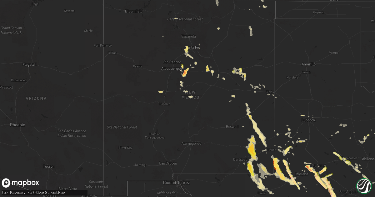
Hail Map in New Mexico on June 9, 2025
Get this storm
June 9 map
$229
one time, instant access
Download today. No call, no setup
Keep the $229
Bought the map and want the full workflow? Apply the entire $229 to a subscription within 7 days. None of it is wasted.
Every map, not just this one
This buys you this map. Subscription and you get every map we run, in the markets you choose from a few cities to whole states to nationwide. Plus real-time alerts the moment a storm fires.
Contact data
Name, contact info, occupancy, even credit band for addresses in the footprint. You go from where it hit to who to call.
Become the source they trust
Unlimited branding weather history reports on demand. You already have the documented answer ready for the property owner, and you are the one who showed up with it.
Property data and RoofTrace estimates
Pull up any address you have got, its value and the exact code rules for that jurisdiction, straight from One Click Code. Then RoofTrace estimates the squares, pitch, and roof value, priced the way you price.
Storm reports in New Mexico
New Mexico
| Date | Description |
|---|---|
| 06/09/20255:50 PM CDT | Large broken tree limbs in roosevelt park from strong winds. |
| 06/09/20255:30 PM CDT | A local report indicates 2.50 inch wind near Moriarty |
| 06/09/20255:30 PM CDT | A local report indicates 1.00 inch wind near Sandia Park |
| 06/09/20255:30 PM CDT | Hail size ranged from half inch to half dollar size. |
| 06/09/20255:25 PM CDT | Hail size ranged from 1/2 inch to half dollar size. |
| 06/09/20255:20 PM CDT | A local report indicates 1.00 inch wind near Sandia Park |
| 06/09/20255:10 PM CDT | Report from mping: half dollar |
| 06/09/20255:00 PM CDT | Golf ball size hail shattered rain gauge and resulted in house and vehicle damage as well. |
| 06/09/20254:45 PM CDT | Hail storm from 1545 to 1605 with damage. Tree... House and auto damage. Hail size ranged from golf ball to baseball size. |
| 06/09/20251:00 AM CDT | Mesonet station fw9688 jal. |
| 06/09/202512:02 AM CDT | Mesonet station nmc36 malaga. Time estimated by radar. |
| 06/08/20258:25 PM CDT | Spotter reports broken tree branches of about 5 inches in diameter from trees around her house. |
| 06/08/20258:25 PM CDT | A local report indicates 60 MPH wind near Taiban |
| 06/08/20258:20 PM CDT | Trained spotter in house in southern quay county reports an estimated wind speed of 65 mph and small broken tree limbs and branches. |
| 06/08/20257:10 PM CDT | Quarter size hail being reported along i-40 near newkirk. Heavy hail accumulations are covering the roadways. |
All States Impacted by Hail Map on June 9, 2025
Cities Impacted by Hail Map on June 9, 2025
- Hermleigh, TX
- Snyder, TX
- Randolph, AL
- Roscoe, TX
- Loraine, TX
- Brierfield, AL
- Sweetwater, TX
- Nolan, TX
- Blackwell, TX
- Tuscola, TX
- Wingate, TX
- Ovalo, TX
- Winters, TX
- Talpa, TX
- Ballinger, TX
- Patterson, GA
- Blackshear, GA
- Ochlocknee, GA
- Moultrie, GA
- Hartford, AL
- Dothan, AL
- Slocomb, AL
- Valdosta, GA
- Quitman, GA
- Adel, GA
- Jackson, AL
- Pavo, GA
- Gainestown, AL
- Weston, CO
- Frisco City, AL
- Uriah, AL
- Williston, TN
- Moscow, TN
- Bainbridge, GA
- Somerville, TN
- Rickman, TN
- Cookeville, TN
- Folkston, GA
- Livingston, TN
- Kewadin, MI
- Ellsworth, MI
- Harbor Springs, MI
- Howard, CO
- Evergreen, AL
- Tererro, NM
- Lyons, GA
- Cotopaxi, CO
- Ocate, NM
- Levering, MI
- Pellston, MI
- Castleberry, AL
- Santa Fe, NM
- Carp Lake, MI
- Pleasantville, PA
- Oil City, PA
- Andalusia, AL
- Red Level, AL
- Tierra Amarilla, NM
- Mackinaw City, MI
- Bonifay, FL
- State Line, MS
- Leakesville, MS
- Brewton, AL
- Mountainair, NM
- Sugar Grove, PA
- Panama, NY
- Bear Lake, PA
- Ashville, NY
- Columbus, PA
- Register, GA
- Metter, GA
- Arroyo Hondo, NM
- Indian River, MI
- Westville, FL
- Statesboro, GA
- Jamestown, NY
- Raton, NM
- Cheboygan, MI
- Lakewood, NY
- Pittsfield, PA
- Cripple Creek, CO
- Kinross, MI
- Callensburg, PA
- Emlenton, PA
- Sligo, PA
- Parker, PA
- Leeper, PA
- Lucinda, PA
- Kennedy, NY
- Falconer, NY
- Frewsburg, NY
- Des Moines, NM
- Flomaton, AL
- Eckerman, MI
- Rimersburg, PA
- Johannesburg, MI
- Florissant, CO
- Gaylord, MI
- Karns City, PA
- East Brady, PA
- Fort Meade, FL
- Estancia, NM
- Torreon, NM
- Marienville, PA
- Vowinckel, PA
- Vinegar Bend, AL
- Randolph, NY
- New Bethlehem, PA
- Clarion, PA
- Summerville, PA
- Strattanville, PA
- Corsica, PA
- Haines City, FL
- Huger, SC
- Atmore, AL
- Magdalena, NM
- Grenville, NM
- Shippenville, PA
- Knox, PA
- Little River, AL
- Citronelle, AL
- Chunchula, AL
- Hastings, MI
- Summerville, SC
- Ladson, SC
- Goose Creek, SC
- Charleston, SC
- Hanahan, SC
- Awendaw, SC
- Tijeras, NM
- Sigel, PA
- Brookville, PA
- Great Valley, NY
- Freeport, MI
- Lake Odessa, MI
- Winter Haven, FL
- Cerrillos, NM
- Ona, WV
- Atlanta, MI
- Salida, CO
- Cuba, NM
- Jemez Springs, NM
- Marianna, FL
- Edgewood, NM
- Newton, AL
- Malone, FL
- Moriarty, NM
- Humble, TX
- Clarington, PA
- Portland, MI
- Willard, NM
- Houston, TX
- Wilmer, AL
- Lamy, NM
- Moore Haven, FL
- Okeechobee, FL
- Muir, MI
- Pewamo, MI
- Lyons, MI
- Waller, TX
- Hockley, TX
- Claunch, NM
- Tomball, TX
- Cypress, TX
- Saint Helen, MI
- Lucedale, MS
- Cat Spring, TX
- Roscommon, MI
- Grayling, MI
- Ashford, AL
- Columbia, MS
- Sebring, FL
- Bath, NY
- Canisteo, NY
- Cameron, NY
- Ribera, NM
- Sandia Park, NM
- Lewiston, MI
- Sealy, TX
- Stanley, NM
- Anton Chico, NM
- Saraland, AL
- Sweet Water, AL
- Linden, AL
- Santa Rosa, NM
- Kingwood, TX
- Huffman, TX
- Greenwood, SC
- Bradley, SC
- Galeton, PA
- Mayport, PA
- Dayton, TX
- Abbeville, SC
- Magnolia, TX
- Smithville, TX
- Rosanky, TX
- Waelder, TX
- Spring, TX
- Gaines, PA
- Vaughn, NM
- Ringgold, PA
- Timblin, PA
- Punxsutawney, PA
- Galena Park, TX
- Worthville, PA
- Sprankle Mills, PA
- Faunsdale, AL
- Pinehurst, TX
- Conroe, TX
- Savona, NY
- Newkirk, NM
- Cuervo, NM
- Stanton, TX
- Hammondsport, NY
- Uniontown, AL
- Gladstone, NM
- Big Spring, TX
- Garden City, TX
- Bradford, NY
- Dundee, NY
- Watkins Glen, NY
- Beaver Dams, NY
- Roy, NM
- New Caney, TX
- Porter, TX
- Bladenboro, NC
- Clarkton, NC
- Semmes, AL
- Boise City, OK
- Elizabethtown, NC
- Alleyton, TX
- Milesburg, PA
- Bellefonte, PA
- Julian, PA
- Fleming, PA
- Howard, PA
- Hector, NY
- Rock Stream, NY
- Burdett, NY
- Eight Mile, AL
- Splendora, TX
- Old Fields, WV
- Moorefield, WV
- Purgitsville, WV
- Columbus, TX
- Vancourt, TX
- Romney, WV
- Senoia, GA
- Livingston, AL
- Weimar, TX
- Wiggins, MS
- Lumberton, MS
- House, NM
- Glidden, TX
- Rio, WV
- Augusta, WV
- Shanks, WV
- Sterling City, TX
- Trumansburg, NY
- Fort Sumner, NM
- Tucumcari, NM
- Eldorado, TX
- Junction City, GA
- Mauk, GA
- Oxford, MS
- Pontotoc, MS
- Paris, MS
- Randolph, MS
- Huntingdon, PA
- Gray, GA
- Taiban, NM
- Perkinston, MS
- Spring Mills, PA
- Everett, PA
- Hopewell, PA
- Boalsburg, PA
- Centre Hall, PA
- Yeso, NM
- Yatesville, GA
- Somes Bar, CA
- Happy Camp, CA
- Mcalister, NM
- Floyd, NM
- Melrose, NM
- Reedsville, PA
- Delray, WV
- Lawley, AL
- Milroy, PA
- Six Mile Run, PA
- Belleville, PA
- McHenry, MS
- Macon, GA
- Christoval, TX
- Culloden, GA
- Mertzon, TX
- Yeagertown, PA
- Lewistown, PA
- Coburn, PA
- Grady, AR
- Pine Bluff, AR
- Hallettsville, TX
- Schulenburg, TX
- McClure, PA
- Clovis, NM
- Kiln, MS
- Andrews, TX
- Roswell, NM
- Pass Christian, MS
- Gulfport, MS
- Conchas Dam, NM
- Woodward, PA
- Millmont, PA
- Petersburg, PA
- Gunnison, CO
- Orbisonia, PA
- Shirleysburg, PA
- Blairs Mills, PA
- Rockhill Furnace, PA
- Big Lake, TX
- East Waterford, PA
- Eunice, NM
- Mount Union, PA
- McVeytown, PA
- Diberville, MS
- Saucier, MS
- Ocean Springs, MS
- Long Beach, MS
- Biloxi, MS
- Vancleave, MS
- Gautier, MS
- Moss Point, MS
- Ozona, TX
- Seminole, TX
- Flatonia, TX
- Mifflintown, PA
- Mifflin, PA
- Port Royal, PA
- Honey Grove, PA
- Hereford, TX
- Sudan, TX
- Muleshoe, TX
- Adrian, TX
- San Jon, NM
- Broadview, NM
- Bard, NM
- Friona, TX
- Texico, NM
- Farwell, TX
- Portales, NM
- Bovina, TX
- Goldsmith, TX
- Belle Glade, FL
- Earth, TX
- Como, CO
- Tatum, NM
- Odessa, TX
- Sonora, TX
- Hagerman, NM
- Lake George, CO
- Lovington, NM
- Artesia, NM
- Kermit, TX
- Maljamar, NM
- Carlsbad, NM
- Gerry, NY
- Plains, TX
- Burnham, PA
- Templeton, PA
- Three Springs, PA
- Midland, TX
- Marble, PA
- Cranberry, PA
- Hobbs, NM
- Meadow, TX
- Loving, NM
- Shallowater, TX
- Anton, TX
- Levelland, TX
- Tokio, TX
- Brownfield, TX
- Notrees, TX
- Midkiff, TX
- McCamey, TX
- Lubbock, TX
- Idalou, TX
- Jal, NM
- Spur, TX
- Seagraves, TX
- Mentone, TX
- Loop, TX
- Welch, TX
- Lamesa, TX
- Pecos, TX
- Rule, TX
- Stamford, TX
- Cedar Crest, NM
- Odonnell, TX
- Aspermont, TX
- Pyote, TX
- Haskell, TX
- Tarzan, TX
- Neely, MS
- Opp, AL
- Poplarville, MS
- Deer Park, AL
- Diamondhead, MS
- Hamlin, TX
- Lenorah, TX
- Barstow, TX
- Florala, AL
- Monahans, TX
- Imperial, TX
- Westbrook, TX
- Throckmorton, TX
- Coyanosa, TX
- Grandfalls, TX
- Crane, TX
- Rankin, TX
- Barney, GA
- Jayton, TX
- Ira, TX
- Barnhart, TX
- San Angelo, TX
- Valera, TX
- Voss, TX
- Santa Anna, TX
- Coleman, TX
- Cross Plains, TX
- Eden, TX
- Brownwood, TX
- Fort McKavett, TX
- Menard, TX
- Rising Star, TX
- Melvin, TX
- Early, TX
- Junction, TX
- Brady, TX
- May, TX
- Weinert, TX
- Fluvanna, TX
- Rotan, TX


