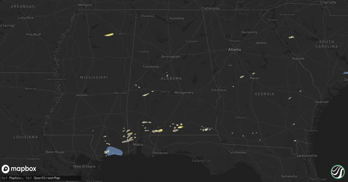
Hail Map in Alabama on June 9, 2025
Get this storm
June 9 map
$229
one time, instant access
Download today. No call, no setup
Keep the $229
Bought the map and want the full workflow? Apply the entire $229 to a subscription within 7 days. None of it is wasted.
Every map, not just this one
This buys you this map. Subscription and you get every map we run, in the markets you choose from a few cities to whole states to nationwide. Plus real-time alerts the moment a storm fires.
Contact data
Name, contact info, occupancy, even credit band for addresses in the footprint. You go from where it hit to who to call.
Become the source they trust
Unlimited branding weather history reports on demand. You already have the documented answer ready for the property owner, and you are the one who showed up with it.
Property data and RoofTrace estimates
Pull up any address you have got, its value and the exact code rules for that jurisdiction, straight from One Click Code. Then RoofTrace estimates the squares, pitch, and roof value, priced the way you price.
Storm reports in Alabama
Alabama
| Date | Description |
|---|---|
| 06/09/20255:54 PM CDT | Broadcast media reports a large oak tree ontop of a home and pickup truck on gordon lane in brewton alabama. Time estimated by radar and report via social media. |
| 06/09/20255:29 PM CDT | Member of the public reported quarter-size hail on the south side of dothan. |
| 06/09/20255:25 PM CDT | Reports of a tree down near ridgeview drive and south park avenue. Timing estimated by radar. |
| 06/09/20254:40 PM CDT | Media relayed public report of quarter sized hail south of citronelle. Time estimated via radar. |
| 06/09/20253:35 PM CDT | Public reports ping pong ball sized hail just south of andalusia... Al. |
| 06/09/20251:35 PM CDT | Mesonet station |
| 06/09/202512:40 PM CDT | Corrects previous tstm wnd gst report from 2 ese green acres. Mesonet station |
| 06/09/202512:40 PM CDT | A tree fell on hodgesville road near ross clark circle. |
| 06/08/20257:40 PM CDT | Coffee county 911 center reports a tree down along hwy 167 near hwy 51. |
All States Impacted by Hail Map on June 9, 2025
Cities Impacted by Hail Map on June 9, 2025
- Hermleigh, TX
- Snyder, TX
- Randolph, AL
- Roscoe, TX
- Loraine, TX
- Brierfield, AL
- Sweetwater, TX
- Nolan, TX
- Blackwell, TX
- Tuscola, TX
- Wingate, TX
- Ovalo, TX
- Winters, TX
- Talpa, TX
- Ballinger, TX
- Patterson, GA
- Blackshear, GA
- Ochlocknee, GA
- Moultrie, GA
- Hartford, AL
- Dothan, AL
- Slocomb, AL
- Valdosta, GA
- Quitman, GA
- Adel, GA
- Jackson, AL
- Pavo, GA
- Gainestown, AL
- Weston, CO
- Frisco City, AL
- Uriah, AL
- Williston, TN
- Moscow, TN
- Bainbridge, GA
- Somerville, TN
- Rickman, TN
- Cookeville, TN
- Folkston, GA
- Livingston, TN
- Kewadin, MI
- Ellsworth, MI
- Harbor Springs, MI
- Howard, CO
- Evergreen, AL
- Tererro, NM
- Lyons, GA
- Cotopaxi, CO
- Ocate, NM
- Levering, MI
- Pellston, MI
- Castleberry, AL
- Santa Fe, NM
- Carp Lake, MI
- Pleasantville, PA
- Oil City, PA
- Andalusia, AL
- Red Level, AL
- Tierra Amarilla, NM
- Mackinaw City, MI
- Bonifay, FL
- State Line, MS
- Leakesville, MS
- Brewton, AL
- Mountainair, NM
- Sugar Grove, PA
- Panama, NY
- Bear Lake, PA
- Ashville, NY
- Columbus, PA
- Register, GA
- Metter, GA
- Arroyo Hondo, NM
- Indian River, MI
- Westville, FL
- Statesboro, GA
- Jamestown, NY
- Raton, NM
- Cheboygan, MI
- Lakewood, NY
- Pittsfield, PA
- Cripple Creek, CO
- Kinross, MI
- Callensburg, PA
- Emlenton, PA
- Sligo, PA
- Parker, PA
- Leeper, PA
- Lucinda, PA
- Kennedy, NY
- Falconer, NY
- Frewsburg, NY
- Des Moines, NM
- Flomaton, AL
- Eckerman, MI
- Rimersburg, PA
- Johannesburg, MI
- Florissant, CO
- Gaylord, MI
- Karns City, PA
- East Brady, PA
- Fort Meade, FL
- Estancia, NM
- Torreon, NM
- Marienville, PA
- Vowinckel, PA
- Vinegar Bend, AL
- Randolph, NY
- New Bethlehem, PA
- Clarion, PA
- Summerville, PA
- Strattanville, PA
- Corsica, PA
- Haines City, FL
- Huger, SC
- Atmore, AL
- Magdalena, NM
- Grenville, NM
- Shippenville, PA
- Knox, PA
- Little River, AL
- Citronelle, AL
- Chunchula, AL
- Hastings, MI
- Summerville, SC
- Ladson, SC
- Goose Creek, SC
- Charleston, SC
- Hanahan, SC
- Awendaw, SC
- Tijeras, NM
- Sigel, PA
- Brookville, PA
- Great Valley, NY
- Freeport, MI
- Lake Odessa, MI
- Winter Haven, FL
- Cerrillos, NM
- Ona, WV
- Atlanta, MI
- Salida, CO
- Cuba, NM
- Jemez Springs, NM
- Marianna, FL
- Edgewood, NM
- Newton, AL
- Malone, FL
- Moriarty, NM
- Humble, TX
- Clarington, PA
- Portland, MI
- Willard, NM
- Houston, TX
- Wilmer, AL
- Lamy, NM
- Moore Haven, FL
- Okeechobee, FL
- Muir, MI
- Pewamo, MI
- Lyons, MI
- Waller, TX
- Hockley, TX
- Claunch, NM
- Tomball, TX
- Cypress, TX
- Saint Helen, MI
- Lucedale, MS
- Cat Spring, TX
- Roscommon, MI
- Grayling, MI
- Ashford, AL
- Columbia, MS
- Sebring, FL
- Bath, NY
- Canisteo, NY
- Cameron, NY
- Ribera, NM
- Sandia Park, NM
- Lewiston, MI
- Sealy, TX
- Stanley, NM
- Anton Chico, NM
- Saraland, AL
- Sweet Water, AL
- Linden, AL
- Santa Rosa, NM
- Kingwood, TX
- Huffman, TX
- Greenwood, SC
- Bradley, SC
- Galeton, PA
- Mayport, PA
- Dayton, TX
- Abbeville, SC
- Magnolia, TX
- Smithville, TX
- Rosanky, TX
- Waelder, TX
- Spring, TX
- Gaines, PA
- Vaughn, NM
- Ringgold, PA
- Timblin, PA
- Punxsutawney, PA
- Galena Park, TX
- Worthville, PA
- Sprankle Mills, PA
- Faunsdale, AL
- Pinehurst, TX
- Conroe, TX
- Savona, NY
- Newkirk, NM
- Cuervo, NM
- Stanton, TX
- Hammondsport, NY
- Uniontown, AL
- Gladstone, NM
- Big Spring, TX
- Garden City, TX
- Bradford, NY
- Dundee, NY
- Watkins Glen, NY
- Beaver Dams, NY
- Roy, NM
- New Caney, TX
- Porter, TX
- Bladenboro, NC
- Clarkton, NC
- Semmes, AL
- Boise City, OK
- Elizabethtown, NC
- Alleyton, TX
- Milesburg, PA
- Bellefonte, PA
- Julian, PA
- Fleming, PA
- Howard, PA
- Hector, NY
- Rock Stream, NY
- Burdett, NY
- Eight Mile, AL
- Splendora, TX
- Old Fields, WV
- Moorefield, WV
- Purgitsville, WV
- Columbus, TX
- Vancourt, TX
- Romney, WV
- Senoia, GA
- Livingston, AL
- Weimar, TX
- Wiggins, MS
- Lumberton, MS
- House, NM
- Glidden, TX
- Rio, WV
- Augusta, WV
- Shanks, WV
- Sterling City, TX
- Trumansburg, NY
- Fort Sumner, NM
- Tucumcari, NM
- Eldorado, TX
- Junction City, GA
- Mauk, GA
- Oxford, MS
- Pontotoc, MS
- Paris, MS
- Randolph, MS
- Huntingdon, PA
- Gray, GA
- Taiban, NM
- Perkinston, MS
- Spring Mills, PA
- Everett, PA
- Hopewell, PA
- Boalsburg, PA
- Centre Hall, PA
- Yeso, NM
- Yatesville, GA
- Somes Bar, CA
- Happy Camp, CA
- Mcalister, NM
- Floyd, NM
- Melrose, NM
- Reedsville, PA
- Delray, WV
- Lawley, AL
- Milroy, PA
- Six Mile Run, PA
- Belleville, PA
- McHenry, MS
- Macon, GA
- Christoval, TX
- Culloden, GA
- Mertzon, TX
- Yeagertown, PA
- Lewistown, PA
- Coburn, PA
- Grady, AR
- Pine Bluff, AR
- Hallettsville, TX
- Schulenburg, TX
- McClure, PA
- Clovis, NM
- Kiln, MS
- Andrews, TX
- Roswell, NM
- Pass Christian, MS
- Gulfport, MS
- Conchas Dam, NM
- Woodward, PA
- Millmont, PA
- Petersburg, PA
- Gunnison, CO
- Orbisonia, PA
- Shirleysburg, PA
- Blairs Mills, PA
- Rockhill Furnace, PA
- Big Lake, TX
- East Waterford, PA
- Eunice, NM
- Mount Union, PA
- McVeytown, PA
- Diberville, MS
- Saucier, MS
- Ocean Springs, MS
- Long Beach, MS
- Biloxi, MS
- Vancleave, MS
- Gautier, MS
- Moss Point, MS
- Ozona, TX
- Seminole, TX
- Flatonia, TX
- Mifflintown, PA
- Mifflin, PA
- Port Royal, PA
- Honey Grove, PA
- Hereford, TX
- Sudan, TX
- Muleshoe, TX
- Adrian, TX
- San Jon, NM
- Broadview, NM
- Bard, NM
- Friona, TX
- Texico, NM
- Farwell, TX
- Portales, NM
- Bovina, TX
- Goldsmith, TX
- Belle Glade, FL
- Earth, TX
- Como, CO
- Tatum, NM
- Odessa, TX
- Sonora, TX
- Hagerman, NM
- Lake George, CO
- Lovington, NM
- Artesia, NM
- Kermit, TX
- Maljamar, NM
- Carlsbad, NM
- Gerry, NY
- Plains, TX
- Burnham, PA
- Templeton, PA
- Three Springs, PA
- Midland, TX
- Marble, PA
- Cranberry, PA
- Hobbs, NM
- Meadow, TX
- Loving, NM
- Shallowater, TX
- Anton, TX
- Levelland, TX
- Tokio, TX
- Brownfield, TX
- Notrees, TX
- Midkiff, TX
- McCamey, TX
- Lubbock, TX
- Idalou, TX
- Jal, NM
- Spur, TX
- Seagraves, TX
- Mentone, TX
- Loop, TX
- Welch, TX
- Lamesa, TX
- Pecos, TX
- Rule, TX
- Stamford, TX
- Cedar Crest, NM
- Odonnell, TX
- Aspermont, TX
- Pyote, TX
- Haskell, TX
- Tarzan, TX
- Neely, MS
- Opp, AL
- Poplarville, MS
- Deer Park, AL
- Diamondhead, MS
- Hamlin, TX
- Lenorah, TX
- Barstow, TX
- Florala, AL
- Monahans, TX
- Imperial, TX
- Westbrook, TX
- Throckmorton, TX
- Coyanosa, TX
- Grandfalls, TX
- Crane, TX
- Rankin, TX
- Barney, GA
- Jayton, TX
- Ira, TX
- Barnhart, TX
- San Angelo, TX
- Valera, TX
- Voss, TX
- Santa Anna, TX
- Coleman, TX
- Cross Plains, TX
- Eden, TX
- Brownwood, TX
- Fort McKavett, TX
- Menard, TX
- Rising Star, TX
- Melvin, TX
- Early, TX
- Junction, TX
- Brady, TX
- May, TX
- Weinert, TX
- Fluvanna, TX
- Rotan, TX


