Hail Map in Austin, TX on June 9, 2019
The weather event in Austin, TX on June 9, 2019 includes Wind and Hail maps. 5 states and 349 cities were impacted and suffered possible damage. The total estimated number of properties impacted is 0.
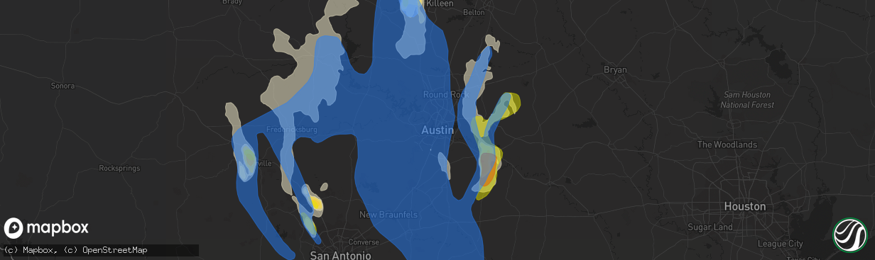
Wind
Hail
0
Estimated number of impacted properties by a 1.00" hail or larger0
Estimated number of impacted properties by a 1.75" hail or larger0
Estimated number of impacted properties by a 2.50" hail or largerStorm reports in Austin, TX
Austin, TX
| Date | Description |
|---|---|
| 06/08/20197:56 PM CDT | Reported through spotternetwork. |
| 06/08/20197:42 PM CDT | Tree down on 15th street near red river st. That is blocking two lanes. |
| 06/08/20197:37 PM CDT | Large tree down blocking ohlen road. |
| 06/08/20197:37 PM CDT | . |
| 06/08/20197:21 PM CDT | A local report indicates 70 MPH wind near MANSFIELD DAM |
| 06/08/20197:12 PM CDT | Large tree limbs knocked down. |
All Cities Impacted by Hail Map on June 9, 2019
- Luling, TX
- Healdton, OK
- Wilson, OK
- Lone Grove, OK
- Copperas Cove, TX
- Taylor, TX
- Hutto, TX
- Lometa, TX
- Lampasas, TX
- Bremond, TX
- Franklin, TX
- Kosse, TX
- Tuttle, OK
- Amber, OK
- Rocksprings, TX
- Wynnewood, OK
- Pauls Valley, OK
- Dripping Springs, TX
- Kempner, TX
- Junction, TX
- Boerne, TX
- Lexington, OK
- Wayne, OK
- Hondo, TX
- Llano, TX
- Marlow, OK
- Ferris, TX
- Waxahachie, TX
- Red Oak, TX
- Palmer, TX
- Ennis, TX
- Wimberley, TX
- Killeen, TX
- Oklahoma City, OK
- Comstock, TX
- Ozona, TX
- Del Rio, TX
- Fredericksburg, TX
- El Reno, OK
- Hamilton, TX
- Sulphur, OK
- Davis, OK
- Marathon, TX
- Bradley, OK
- Streetman, TX
- Rice, TX
- Fairfield, TX
- Chatfield, TX
- Kerens, TX
- Corsicana, TX
- Powell, TX
- Bertram, TX
- Liberty Hill, TX
- Prairie Hill, TX
- Groesbeck, TX
- Coolidge, TX
- Gainesville, TX
- Muenster, TX
- Bend, TX
- San Saba, TX
- Plano, TX
- Allen, TX
- Dawson, TX
- Purdon, TX
- Dallas, TX
- Richardson, TX
- Little Elm, TX
- Frisco, TX
- Rush Springs, OK
- Thornton, TX
- Ada, OK
- Brackettville, TX
- Stephenville, TX
- Ariton, AL
- Wrightsboro, TX
- Gonzales, TX
- Smiley, TX
- Dale, TX
- Harwood, TX
- Cost, TX
- Lockhart, TX
- Norman, OK
- Noble, OK
- Helotes, TX
- Quemado, TX
- Hico, TX
- Dublin, TX
- Evant, TX
- Purmela, TX
- Granger, TX
- Bartlett, TX
- Thrall, TX
- Belton, TX
- Georgetown, TX
- D Hanis, TX
- Burnet, TX
- Fischer, TX
- Choctaw, OK
- Carrollton, TX
- Addison, TX
- Ardmore, OK
- Overbrook, OK
- Marietta, OK
- Bluff Dale, TX
- Kerrville, TX
- Fellsmere, FL
- Lindsay, OK
- Purcell, OK
- Blanchard, OK
- Cashion, OK
- Edmond, OK
- Piedmont, OK
- Frost, TX
- Laughlin Afb, TX
- Ingram, TX
- Harper, TX
- Blanco, TX
- Canyon Lake, TX
- Spring Branch, TX
- Smithville, TX
- Rosanky, TX
- Red Rock, TX
- Pocasset, OK
- Maysville, OK
- Wilmer, TX
- Okarche, OK
- Bethany, OK
- Buchanan Dam, TX
- Mico, TX
- Rio Medina, TX
- Willow City, TX
- Cedar Creek, TX
- Bastrop, TX
- Elgin, TX
- Castroville, TX
- Marble Falls, TX
- Austin, TX
- Moody, TX
- Temple, TX
- Jonesboro, TX
- Binger, OK
- Jensen Beach, FL
- Collinsville, TX
- Dryden, TX
- Kingfisher, OK
- Sachse, TX
- Mustang, OK
- Briggs, TX
- Hennessey, OK
- Immokalee, FL
- Clewiston, FL
- Frostproof, FL
- Lake Wales, FL
- Mason, TX
- Doss, TX
- Kingston, OK
- Lebanon, OK
- Madill, OK
- Spicewood, TX
- Tow, TX
- Cherokee, TX
- Florence, TX
- Duncan, OK
- Ratliff City, OK
- Tussy, OK
- Stuart, FL
- Graham, OK
- Springer, OK
- Rio Frio, TX
- Holland, TX
- Umatilla, FL
- Mead, OK
- Durant, OK
- Thorndale, TX
- Bandera, TX
- San Antonio, TX
- Paoli, OK
- Leakey, TX
- Iredell, TX
- Fort Hood, TX
- Gordon, TX
- Carlton, TX
- Gatesville, TX
- Palm City, FL
- Pontotoc, TX
- Valley Spring, TX
- Art, TX
- Bluffton, TX
- McDade, TX
- Lexington, TX
- Buckholts, TX
- Manor, TX
- Coupland, TX
- Pflugerville, TX
- Newalla, OK
- New Braunfels, TX
- Johnson City, TX
- Ninnekah, OK
- Mannsville, OK
- Dougherty, OK
- Mill Creek, OK
- Tishomingo, OK
- Uvalde, TX
- Sonora, TX
- Maitland, FL
- Casselberry, FL
- Winter Park, FL
- Dover, OK
- Nixon, TX
- The Villages, FL
- Fruitland Park, FL
- Buda, TX
- Kyle, TX
- Concan, TX
- Macomb, OK
- Stratford, OK
- Mcloud, OK
- Elmore City, OK
- Yukon, OK
- Tecumseh, OK
- Byars, OK
- Harrah, OK
- Wanette, OK
- Spencer, OK
- Comfort, TX
- Bonifay, FL
- Drummond, OK
- Era, TX
- Rosston, TX
- Trinidad, TX
- Hunt, TX
- Maxwell, TX
- Martindale, TX
- Round Mountain, TX
- Kingsland, TX
- Castell, TX
- Mountain Home, TX
- Banks, AL
- Forestburg, TX
- Decatur, TX
- Waukomis, OK
- The Colony, TX
- Hennepin, OK
- Indian Lake Estates, FL
- Aubrey, TX
- Celina, TX
- Orlando, FL
- Calera, OK
- Santo, TX
- Wildwood, FL
- Coleman, FL
- Sumterville, FL
- Salado, TX
- Washington, OK
- Seguin, TX
- Kingsbury, TX
- Mexia, TX
- San Marcos, TX
- Valley View, TX
- Ravenna, TX
- Camp Wood, TX
- Colquitt, GA
- Hinton, OK
- Minco, OK
- Garland, TX
- Mesquite, TX
- Sanger, TX
- Morgan, TX
- Alex, OK
- Foster, OK
- Forney, TX
- Sunnyvale, TX
- Rockwall, TX
- Mabank, TX
- Bradley, FL
- Kenefic, OK
- Atoka, OK
- Coleman, OK
- Leander, TX
- Seagoville, TX
- Hutchins, TX
- Balch Springs, TX
- Lancaster, TX
- Bison, OK
- Ames, OK
- Chickasha, OK
- Fort Stockton, TX
- Clayton, AL
- Howe, TX
- Fort Worth, TX
- Pilot Point, TX
- Whitesboro, TX
- Gunter, TX
- Colleyville, TX
- Krum, TX
- Coppell, TX
- Prosper, TX
- Gordonville, TX
- Southlake, TX
- Arlington, TX
- Bedford, TX
- Grand Prairie, TX
- Flower Mound, TX
- Justin, TX
- Argyle, TX
- Scurry, TX
- Tioga, TX
- Lindsay, TX
- Thackerville, OK
- Burneyville, OK
- Irving, TX
- Mckinney, TX
- Lewisville, TX
- Grapevine, TX
- North Richland Hills, TX
- Euless, TX
- Sadler, TX
- Wheatland, OK
- Ponder, TX
- Desoto, TX
- Pottsboro, TX
- Hurst, TX
- Lake Dallas, TX
- Denton, TX
- Duncanville, TX
- Keller, TX
- Sherman, TX
- Roanoke, TX
- Medina, TX
- Pipe Creek, TX
- McQueeney, TX
- Gillett, TX
- Marion, TX
- Leesville, TX
- Horseshoe Bay, TX
- Cibolo, TX
- Del Valle, TX
- Stonewall, TX
- Cedar Park, TX
- Westhoff, TX
- Cuero, TX
- Hye, TX
- Yorktown, TX
- Manchaca, TX
- Round Rock, TX
- Jarrell, TX
- Driftwood, TX
- Stockdale, TX
- Guthrie, OK


