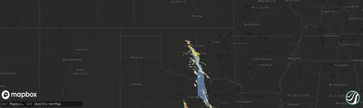
Hail Map in Oklahoma on June 9, 2019
The weather event in Oklahoma on June 9, 2019 includes Wind and Hail maps. 5 states and 349 cities were impacted and suffered possible damage. The total estimated number of properties impacted is 102,208.
Want more than just the map?
Turn this storm into a full workflow.
- Owner + property data so you know who to knock
- OnDemand branded weather history reports to win the "did we even have hail?" argument
- RoofTrace estimate so reps stop guessing numbers at the door
Bought this map? Upgrade within 7 days and we'll credit the $230. (10-15 min setup call)
Wind
Hail
102,208
Estimated number of impacted properties by a 1.00" hail or larger0
Estimated number of impacted properties by a 1.75" hail or larger0
Estimated number of impacted properties by a 2.50" hail or largerStorm reports in Oklahoma
Oklahoma
| Date | Description |
|---|---|
| 06/09/201911:45 AM CDT | A local report indicates 63 MPH wind near 2 SE BURNEYVILLE |
| 06/09/201910:45 AM CDT | Numerous trees and powerlines down from strong winds to the immediate west of arbuckle lake. Time based on radar. |
| 06/09/201910:40 AM CDT | Power line downed by the wind. |
| 06/09/20199:42 AM CDT | A local report indicates 1.00 inch wind near ADA |
| 06/09/20199:33 AM CDT | Several large trees down in roadways across town. |
| 06/09/20199:23 AM CDT | A local report indicates 62 MPH wind near 3 NNW GOLDSBY |
| 06/09/20199:20 AM CDT | Tree limbs up to six inches in diameter snapped off. Additional tree limbs downed by strong winds south to slaughterville. |
| 06/09/20199:18 AM CDT | Measured at max westheimer airport. |
| 06/09/20199:15 AM CDT | Measured at nws forecast office |
| 06/09/20199:15 AM CDT | Siding blown off a house. |
| 06/09/20199:07 AM CDT | A local report indicates 65 MPH wind near 4 NW NORMAN |
| 06/09/20199:03 AM CDT | Numerous trees down. One garage door blown in. |
| 06/09/20198:47 AM CDT | A local report indicates 1.50 inch wind near CHOCTAW |
| 06/09/20198:46 AM CDT | Several large tree branches down around will rogers world airport. |
| 06/09/20198:46 AM CDT | Measured at will rogers world airport |
| 06/09/20198:45 AM CDT | Numerous large trees down. |
| 06/09/20198:20 AM CDT | Numerous power poles damaged... Resulting in power disruptions. |
| 06/09/20198:17 AM CDT | A local report indicates 70 MPH wind near EDMOND |
| 06/09/20198:17 AM CDT | Large tree limb blown off tree |
| 06/09/20198:16 AM CDT | A local report indicates 60 MPH wind near EDMOND |
| 06/09/20198:03 AM CDT | A local report indicates 1.00 inch wind near 5 NE PIEDMONT |
| 06/09/20196:57 AM CDT | At 1155 AM CDT, severe thunderstorms were located along a line extending from near Leon to 3 miles north of Thackerville to near Woodville, moving southeast at 45 mph. Winds over 60 mph have been confirmed with this storm near Burneyville. HAZARD...70 mph wind gusts and quarter size hail. SOURCE...Surface observations and radar indicated. IMPACT...Hail damage to vehicles is expected. Expect considerable tree damage. Wind damage is also likely to mobile homes, roofs, and outbuildings. Locations impacted include... Madill, Marietta, Kingston, Colbert, Thackerville, Leon, Cartwright, Rubottom, Woodville, Burneyville, Lebanon, Willis, Little City, Lake Texoma and Mcbride. |
| 06/09/20195:17 AM CDT | At 1016 AM CDT, severe thunderstorms were located along a line extending from near Byars to near Antioch to near Bray, moving east at 45 mph. HAZARD...70 mph wind gusts and quarter size hail. SOURCE...Radar indicated. IMPACT...Hail damage to vehicles is expected. Expect considerable tree damage. Wind damage is also likely to mobile homes, roofs, and outbuildings. Locations impacted include... Pauls Valley, Sulphur, Davis, Wynnewood, Stratford, Roff, Springer, Elmore City, Velma, Katie, Mill Creek, Fitzhugh, Dougherty, Foster, Tatums, Ratliff City, Hickory, Graham, Turner Falls and Scullin. |
| 06/09/20195:13 AM CDT | At 1013 AM CDT, a severe thunderstorm was located 6 miles east of Gene Autry, moving southeast at 35 mph. HAZARD...60 mph wind gusts and quarter size hail. SOURCE...Radar indicated. IMPACT...Hail damage to vehicles is expected. Expect wind damage to roofs, siding, and trees. Locations impacted include... Madill, Tishomingo, Mannsville, Ravia, Milburn, Gene Autry, Russett, Fillmore, Little City and northeastern Lake Texoma. |
| 06/09/20194:44 AM CDT | At 942 AM CDT, severe thunderstorms were located along a line extending from 3 miles southeast of Macomb to 3 miles east of Wayne to near Lindsay, moving southeast at 35 mph. HAZARD...70 mph wind gusts and quarter size hail. SOURCE...Trained weather spotters and the public have reported numerous large trees have been downed by this storm. Power outages are likely. IMPACT...Hail damage to vehicles is expected. Expect considerable tree damage. Wind damage is also likely to mobile homes, roofs, and outbuildings. Locations impacted include... Pauls Valley, Purcell, Lindsay, Wynnewood, Lexington, Stratford, Konawa, Maysville, Bray, Byng, Elmore City, Wayne, Paoli, Asher, Tribbey, Wanette, Byars, Foster, St. Louis and Rosedale. |
| 06/09/20194:24 AM CDT | At 924 AM CDT, severe thunderstorms were located along a line extending from near Etowah to near Slaughterville to near Dibble, moving south at 40 mph. HAZARD...70 mph wind gusts and penny size hail. SOURCE...Radar indicated. IMPACT...Expect considerable tree damage. Damage is likely to mobile homes, roofs, and outbuildings. Locations impacted include... Purcell, Slaughterville, Lexington, Wayne, Washington, Rosedale, Criner and Payne. |
| 06/09/20194:12 AM CDT | At 912 AM CDT, a severe thunderstorm was located over southeastern Norman, or near Lake Thunderbird, moving southeast at 50 mph. HAZARD...60 mph wind gusts and penny size hail. SOURCE...Radar indicated. IMPACT...Expect damage to roofs, siding, and trees. Locations impacted include... Eastern Norman, Pink, Tribbey, Etowah, Brooksville, Macomb, Stella, Lake Thunderbird and Little Axe. |
| 06/09/20193:59 AM CDT | At 859 AM CDT, a severe thunderstorm was located over western Norman, or 8 miles north of Goldsby, moving south at 30 mph. HAZARD...70 mph wind gusts and quarter size hail. SOURCE...Radar indicated. IMPACT...Hail damage to vehicles is expected. Expect considerable tree damage. Wind damage is also likely to mobile homes, roofs, and outbuildings. Locations impacted include... Norman, Moore, Newcastle, Noble, Slaughterville, Goldsby, Washington and Cole. |
| 06/09/20193:41 AM CDT | At 840 AM CDT, a severe thunderstorm was located over Newalla, moving east at 40 mph. HAZARD...60 mph wind gusts and quarter size hail. SOURCE...Radar indicated. IMPACT...Hail damage to vehicles is expected. Expect wind damage to roofs, siding, and trees. Locations impacted include... Southeastern Oklahoma City, Shawnee, Tecumseh, Choctaw, Harrah, McLoud, Meeker, Earlsboro, Johnson, Dale, Newalla, Bethel Acres and Aydelotte. |
| 06/09/20193:37 AM CDT | At 837 AM CDT, a severe thunderstorm was located over southwestern Oklahoma City, or near The Capitol, moving southeast at 35 mph. HAZARD...Golf ball size hail and 60 mph wind gusts. SOURCE...Radar indicated. IMPACT...People and animals outdoors will be injured. Expect hail damage to roofs, siding, windows, and vehicles. Expect wind damage to roofs, siding, and trees. Locations impacted include... Oklahoma City, northwestern Norman, Moore, Midwest City, Del City, Choctaw, Spencer, Nichols Hills, Nicoma Park, Valley Brook, Tinker Air Force Base, Stanley Draper Lake, Forest Park, Lake Aluma and Smith Village. |
| 06/09/20193:23 AM CDT | At 822 AM CDT, a severe thunderstorm was located over northeastern Oklahoma City, or 5 miles northeast of Lake Aluma, moving southeast at 40 mph. HAZARD...60 mph wind gusts and penny size hail. SOURCE...Trained weather spotters. IMPACT...Expect damage to roofs, siding, and trees. Locations impacted include... Eastern Oklahoma City, southeastern Edmond, Midwest City, Choctaw, Harrah, Spencer, Jones, Nicoma Park, Luther, Arcadia, Newalla, Tinker Air Force Base, Forest Park and Lake Aluma. |
| 06/09/20192:56 AM CDT | At 756 AM CDT, a severe thunderstorm was located 4 miles northeast of Piedmont, moving southeast at 35 mph. HAZARD...70 mph wind gusts and ping pong ball size hail. SOURCE...Radar indicated. IMPACT...People and animals outdoors will be injured. Expect hail damage to roofs, siding, windows, and vehicles. Expect considerable tree damage. Wind damage is also likely to mobile homes, roofs, and outbuildings. Locations impacted include... Northwestern Oklahoma City, Edmond, Yukon, Bethany, Warr Acres, The Village, Piedmont, Nichols Hills and Woodlawn Park. |
| 06/09/20192:37 AM CDT | At 736 AM CDT, a severe thunderstorm was located 6 miles northwest of Cashion, moving east at 40 mph. HAZARD...Golf ball size hail and 60 mph wind gusts. SOURCE...Radar indicated. IMPACT...People and animals outdoors will be injured. Expect hail damage to roofs, siding, windows, and vehicles. Expect wind damage to roofs, siding, and trees. Locations impacted include... Northern Oklahoma City, Edmond, Guthrie, Crescent, Cashion, Cedar Valley, Arcadia, Cimarron City, Meridian, Navina and Seward. |
Cities Impacted by Hail Map on June 9, 2019
- Luling, TX
- Healdton, OK
- Wilson, OK
- Lone Grove, OK
- Copperas Cove, TX
- Taylor, TX
- Hutto, TX
- Lometa, TX
- Lampasas, TX
- Bremond, TX
- Franklin, TX
- Kosse, TX
- Tuttle, OK
- Amber, OK
- Rocksprings, TX
- Wynnewood, OK
- Pauls Valley, OK
- Dripping Springs, TX
- Kempner, TX
- Junction, TX
- Boerne, TX
- Lexington, OK
- Wayne, OK
- Hondo, TX
- Llano, TX
- Marlow, OK
- Ferris, TX
- Waxahachie, TX
- Red Oak, TX
- Palmer, TX
- Ennis, TX
- Wimberley, TX
- Killeen, TX
- Oklahoma City, OK
- Comstock, TX
- Ozona, TX
- Del Rio, TX
- Fredericksburg, TX
- El Reno, OK
- Hamilton, TX
- Sulphur, OK
- Davis, OK
- Marathon, TX
- Bradley, OK
- Streetman, TX
- Rice, TX
- Fairfield, TX
- Chatfield, TX
- Kerens, TX
- Corsicana, TX
- Powell, TX
- Bertram, TX
- Liberty Hill, TX
- Prairie Hill, TX
- Groesbeck, TX
- Coolidge, TX
- Gainesville, TX
- Muenster, TX
- Bend, TX
- San Saba, TX
- Plano, TX
- Allen, TX
- Dawson, TX
- Purdon, TX
- Dallas, TX
- Richardson, TX
- Little Elm, TX
- Frisco, TX
- Rush Springs, OK
- Thornton, TX
- Ada, OK
- Brackettville, TX
- Stephenville, TX
- Ariton, AL
- Wrightsboro, TX
- Gonzales, TX
- Smiley, TX
- Dale, TX
- Harwood, TX
- Cost, TX
- Lockhart, TX
- Norman, OK
- Noble, OK
- Helotes, TX
- Quemado, TX
- Hico, TX
- Dublin, TX
- Evant, TX
- Purmela, TX
- Granger, TX
- Bartlett, TX
- Thrall, TX
- Belton, TX
- Georgetown, TX
- D Hanis, TX
- Burnet, TX
- Fischer, TX
- Choctaw, OK
- Carrollton, TX
- Addison, TX
- Ardmore, OK
- Overbrook, OK
- Marietta, OK
- Bluff Dale, TX
- Kerrville, TX
- Fellsmere, FL
- Lindsay, OK
- Purcell, OK
- Blanchard, OK
- Cashion, OK
- Edmond, OK
- Piedmont, OK
- Frost, TX
- Laughlin Afb, TX
- Ingram, TX
- Harper, TX
- Blanco, TX
- Canyon Lake, TX
- Spring Branch, TX
- Smithville, TX
- Rosanky, TX
- Red Rock, TX
- Pocasset, OK
- Maysville, OK
- Wilmer, TX
- Okarche, OK
- Bethany, OK
- Buchanan Dam, TX
- Mico, TX
- Rio Medina, TX
- Willow City, TX
- Cedar Creek, TX
- Bastrop, TX
- Elgin, TX
- Castroville, TX
- Marble Falls, TX
- Austin, TX
- Moody, TX
- Temple, TX
- Jonesboro, TX
- Binger, OK
- Jensen Beach, FL
- Collinsville, TX
- Dryden, TX
- Kingfisher, OK
- Sachse, TX
- Mustang, OK
- Briggs, TX
- Hennessey, OK
- Immokalee, FL
- Clewiston, FL
- Frostproof, FL
- Lake Wales, FL
- Mason, TX
- Doss, TX
- Kingston, OK
- Lebanon, OK
- Madill, OK
- Spicewood, TX
- Tow, TX
- Cherokee, TX
- Florence, TX
- Duncan, OK
- Ratliff City, OK
- Tussy, OK
- Stuart, FL
- Graham, OK
- Springer, OK
- Rio Frio, TX
- Holland, TX
- Umatilla, FL
- Mead, OK
- Durant, OK
- Thorndale, TX
- Bandera, TX
- San Antonio, TX
- Paoli, OK
- Leakey, TX
- Iredell, TX
- Fort Hood, TX
- Gordon, TX
- Carlton, TX
- Gatesville, TX
- Palm City, FL
- Pontotoc, TX
- Valley Spring, TX
- Art, TX
- Bluffton, TX
- McDade, TX
- Lexington, TX
- Buckholts, TX
- Manor, TX
- Coupland, TX
- Pflugerville, TX
- Newalla, OK
- New Braunfels, TX
- Johnson City, TX
- Ninnekah, OK
- Mannsville, OK
- Dougherty, OK
- Mill Creek, OK
- Tishomingo, OK
- Uvalde, TX
- Sonora, TX
- Maitland, FL
- Casselberry, FL
- Winter Park, FL
- Dover, OK
- Nixon, TX
- The Villages, FL
- Fruitland Park, FL
- Buda, TX
- Kyle, TX
- Concan, TX
- Macomb, OK
- Stratford, OK
- Mcloud, OK
- Elmore City, OK
- Yukon, OK
- Tecumseh, OK
- Byars, OK
- Harrah, OK
- Wanette, OK
- Spencer, OK
- Comfort, TX
- Bonifay, FL
- Drummond, OK
- Era, TX
- Rosston, TX
- Trinidad, TX
- Hunt, TX
- Maxwell, TX
- Martindale, TX
- Round Mountain, TX
- Kingsland, TX
- Castell, TX
- Mountain Home, TX
- Banks, AL
- Forestburg, TX
- Decatur, TX
- Waukomis, OK
- The Colony, TX
- Hennepin, OK
- Indian Lake Estates, FL
- Aubrey, TX
- Celina, TX
- Orlando, FL
- Calera, OK
- Santo, TX
- Wildwood, FL
- Coleman, FL
- Sumterville, FL
- Salado, TX
- Washington, OK
- Seguin, TX
- Kingsbury, TX
- Mexia, TX
- San Marcos, TX
- Valley View, TX
- Ravenna, TX
- Camp Wood, TX
- Colquitt, GA
- Hinton, OK
- Minco, OK
- Garland, TX
- Mesquite, TX
- Sanger, TX
- Morgan, TX
- Alex, OK
- Foster, OK
- Forney, TX
- Sunnyvale, TX
- Rockwall, TX
- Mabank, TX
- Bradley, FL
- Kenefic, OK
- Atoka, OK
- Coleman, OK
- Leander, TX
- Seagoville, TX
- Hutchins, TX
- Balch Springs, TX
- Lancaster, TX
- Bison, OK
- Ames, OK
- Chickasha, OK
- Fort Stockton, TX
- Clayton, AL
- Howe, TX
- Fort Worth, TX
- Pilot Point, TX
- Whitesboro, TX
- Gunter, TX
- Colleyville, TX
- Krum, TX
- Coppell, TX
- Prosper, TX
- Gordonville, TX
- Southlake, TX
- Arlington, TX
- Bedford, TX
- Grand Prairie, TX
- Flower Mound, TX
- Justin, TX
- Argyle, TX
- Scurry, TX
- Tioga, TX
- Lindsay, TX
- Thackerville, OK
- Burneyville, OK
- Irving, TX
- Mckinney, TX
- Lewisville, TX
- Grapevine, TX
- North Richland Hills, TX
- Euless, TX
- Sadler, TX
- Wheatland, OK
- Ponder, TX
- Desoto, TX
- Pottsboro, TX
- Hurst, TX
- Lake Dallas, TX
- Denton, TX
- Duncanville, TX
- Keller, TX
- Sherman, TX
- Roanoke, TX
- Medina, TX
- Pipe Creek, TX
- McQueeney, TX
- Gillett, TX
- Marion, TX
- Leesville, TX
- Horseshoe Bay, TX
- Cibolo, TX
- Del Valle, TX
- Stonewall, TX
- Cedar Park, TX
- Westhoff, TX
- Cuero, TX
- Hye, TX
- Yorktown, TX
- Manchaca, TX
- Round Rock, TX
- Jarrell, TX
- Driftwood, TX
- Stockdale, TX
- Guthrie, OK


