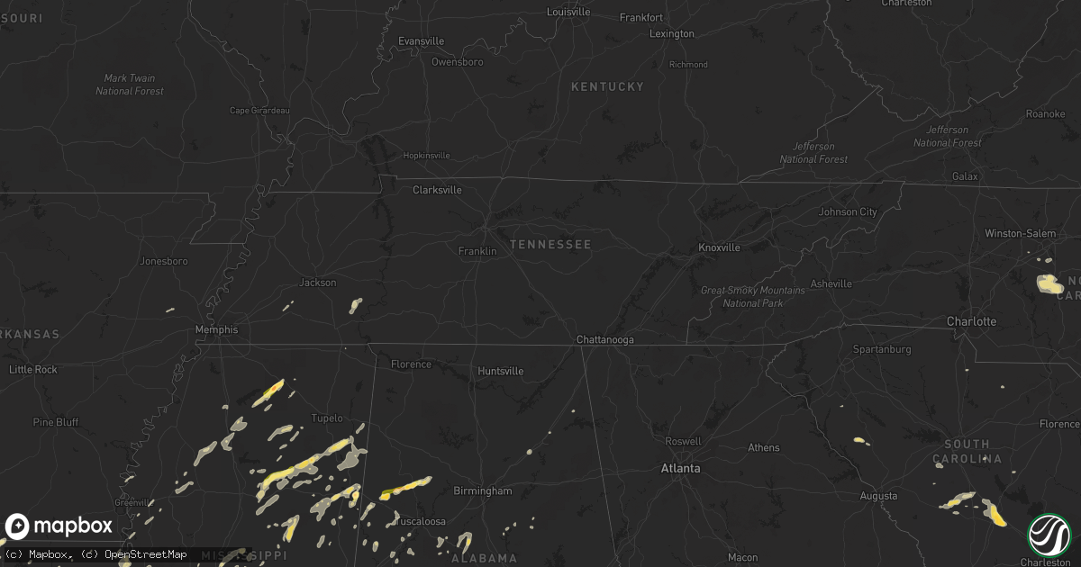
Hail Map in Tennessee on June 9, 2014
Get this storm
June 9 map
$229
one time, instant access
Download today. No call, no setup
Keep the $229
Bought the map and want the full workflow? Apply the entire $229 to a subscription within 7 days. None of it is wasted.
Every map, not just this one
This buys you this map. Subscription and you get every map we run, in the markets you choose from a few cities to whole states to nationwide. Plus real-time alerts the moment a storm fires.
Contact data
Name, contact info, occupancy, even credit band for addresses in the footprint. You go from where it hit to who to call.
Become the source they trust
Unlimited branding weather history reports on demand. You already have the documented answer ready for the property owner, and you are the one who showed up with it.
Property data and RoofTrace estimates
Pull up any address you have got, its value and the exact code rules for that jurisdiction, straight from One Click Code. Then RoofTrace estimates the squares, pitch, and roof value, priced the way you price.
Storm reports in Tennessee
Tennessee
| Date | Description |
|---|---|
| 06/09/201410:00 AM CDT | Tree down on harpeth-peytonsville road at lewisburg pike blocking one lane |
| 06/08/201411:20 PM CDT | Tree down along route 27. |
| 06/08/201410:40 PM CDT | A large tree was downed on canton lane in health place subdivision in franklin. |
| 06/08/201410:08 PM CDT | A tree was reported down on carnton lane blocking the roadway near franklin. |
| 06/08/201410:03 PM CDT | Large tree limbs down at residence on goose creek road |
| 06/08/201410:00 PM CDT | Tree down on harpeth-peytonsville road at lewisburg pike blocking one lane |
| 06/08/20149:44 PM CDT | Estimated 60 mph wind gust in extreme southwestern portion of dickson county near interstate 40. |
| 06/08/20149:20 PM CDT | Multiple power lines down and a tree fallen at the intersection of rose road and highway 31s. |
| 06/08/20149:08 PM CDT | Trees were downed just about three miles west of lawrenceburg near the intersection of u.s. Highway 64 and state road 240 near the red hill community. Just southeast of |
| 06/08/20149:08 PM CDT | Large tree was downed on a house on commerce street in loretto. |
| 06/08/20148:53 PM CDT | A tree was reported down in the community of flatwoods along highway 13 south. |
| 06/08/20148:29 PM CDT | Trees were reported down in the city of collinwood along highway 13. |
All States Impacted by Hail Map on June 9, 2014
Cities Impacted by Hail Map on June 9, 2014
- Sardis, TN
- Enville, TN
- Milledgeville, TN
- Morris Chapel, TN
- Seagrove, NC
- Asheboro, NC
- Norway, SC
- Denmark, SC
- Cope, SC
- Mangham, LA
- Turner, MT
- Bowman, SC
- Harleyville, SC
- Dorchester, SC
- Saint George, SC
- Meyersville, TX
- Goliad, TX
- Yorktown, TX
- West Point, MS
- Houston, MS
- Muldoon, TX
- La Grange, TX
- Fayette, AL
- Kennedy, AL
- Thomasville, NC
- Trinity, NC
- Potts Camp, MS
- Abbeville, MS
- Hickory Flat, MS
- Oxford, MS
- Fayetteville, TX
- Eupora, MS
- Chatham, LA
- Fort Lauderdale, FL
- Columbus, MS
- Victoria, TX
- Boligee, AL
- Lena, MS
- Walnut Grove, MS
- Forest, MS
- Schulenburg, TX
- Weimar, TX
- Zavalla, TX
- Denton, NC
- Troy, NC
- Star, NC
- Magee, MS
- Mantee, MS
- Bellefontaine, MS
- Okolona, MS
- Amory, MS
- Aberdeen, MS
- Raleigh, MS
- Lake, MS
- Ocala, FL
- Summerfield, FL
- Indianola, MS
- Greenwood Springs, MS
- Spearsville, LA
- Lillie, LA
- Canton, MS
- Camden, MS
- Houlka, MS
- Smithville, MS
- Fulton, MS
- Tremont, MS
- Deville, LA
- Leesville, LA
- Anacoco, LA
- Shelbyville, TX
- Bay Springs, MS
- Stringer, MS
- Charleston, MS
- Sylacauga, AL
- Childersburg, AL
- Cedarbluff, MS
- Oakland, MS
- Vicksburg, MS
- Kissimmee, FL
- Monroe, LA
- Livingston, AL
- Cleveland, TX
- Ethelsville, AL
- Carrollton, AL
- Chinook, MT
- Hogeland, MT
- Winnfield, LA
- Estero, FL
- Columbia, LA
- West Monroe, LA
- Grayson, LA
- Orangeburg, SC
- Cordova, SC
- Many, LA
- Belmont, LA
- Hallettsville, TX
- Pheba, MS
- Mathiston, MS
- Maben, MS
- Vidor, TX
- Orange, TX
- Benton, MS
- Shuqualak, MS
- Gordo, AL
- Millport, AL
- Reform, AL
- Broaddus, TX
- Clermont, FL
- Edna, TX
- Louise, TX
- Sheridan, TX
- Sublime, TX
- Ganado, TX
- Garwood, TX
- Sallis, MS
- Bunnell, FL
- Taylorsville, MS
- Woodland, MS
- Stewart, MS
- Prairie, MS
- Kilmichael, MS
- Livingston, TX
- Starkville, MS
- Goodman, MS
- Pickens, MS
- Kaufman, TX
- Kemp, TX
- Lake Providence, LA
- Transylvania, LA
- Rolling Fork, MS
- Mayersville, MS
- Fairmont, NC
- Lumberton, NC
- Rowland, NC
- Berry, AL
- Ashville, AL
- Steele, AL
- Mendenhall, MS
- Belleview, FL
- Ackerman, MS
- Weir, MS
- French Camp, MS
- Ethel, MS
- Vaiden, MS
- Oakland, TX
- Benoit, MS
- Corinth, MS
- Burkeville, TX
- Brent, AL
- Centreville, AL
- Duncanville, AL
- Eutaw, AL
- Coldspring, TX
- Shepherd, TX
- Louisville, MS
- Utica, MS
- Brandon, MS
- Pelahatchie, MS
- Sardis, MS
- Batesville, MS
- Dry Creek, LA
- Grant, LA
- Sugartown, LA
- Talladega, AL
- Milam, TX
- Pontotoc, MS
- Henderson, TX
- Whiteville, TN
- Somerville, TN
- Gadsden, AL
- Collins, MS
- Marthaville, LA
- Robeline, LA
- Lufkin, TX
- Diboll, TX
- Noxapater, MS
- McCool, MS
- Aimwell, LA
- Steens, MS
- Waldo, FL
- Beaumont, TX
- Downsville, LA
- Pineville, LA
- Bamberg, SC
- Palacios, TX
- Florien, LA
- Tillatoba, MS
- Cascilla, MS
- Glendora, MS
- Minter City, MS
- Aliceville, AL
- Brooksville, MS
- Crawford, MS
- Artesia, MS
- Vossburg, MS
- Stonewall, MS
- Paulding, MS
- Heidelberg, MS
- Enterprise, MS
- Pachuta, MS
- Quitman, MS
- Bradley, SC
- Florence, MS
- Salley, SC
- Water Valley, MS
- Courtland, MS
- Pope, MS
- Conroe, TX
- Carthage, MS
- Kosciusko, MS
- Brierfield, AL
- Rose Hill, MS
- Fort Payne, AL
- Gore Springs, MS
- Duck Hill, MS
- Bastrop, LA
- Rockdale, TX
- Thorndale, TX
- Morton, MS
- Flowood, MS
- Chatham, MS
- Greenville, MS
- Glen Allan, MS
- Mize, MS
- Louin, MS
- Oak Ridge, LA
- Lexington, TX
- Lawley, AL
- Randolph, AL
- West Blocton, AL
- Onalaska, TX
- Alto, TX
- Philadelphia, MS
- Macon, MS
- Sulligent, AL
- Caledonia, MS
- Hamilton, MS
- Yoakum, TX
- Bernice, LA
- Junction City, AR
- Randolph, MS
- Myrtle, MS
- Mount Olive, MS
- Pulaski, MS
- Calhoun City, MS
- Vardaman, MS
- Marion, AL
- Evans, LA
- New Albany, MS
- Fort Lawn, SC
- Doddsville, MS
- Honea Path, SC
- Donalds, SC
- Kershaw, SC
- Deridder, LA
- Troy, SC
- Manning, SC
- Newellton, LA
- Jones, LA
- Hawthorne, FL
- Sophia, NC
- Pittsboro, MS
- Baskin, LA
- Rayville, LA
- Winnsboro, LA
- Fosters, AL
- Hornbeck, LA
- Dime Box, TX
- Caldwell, TX
- Neeses, SC
- Blackville, SC
- Brookeland, TX
- Wiergate, TX
- Noble, LA
- Winter Garden, FL
- Preston, MS
- Sunflower, MS
- Grenada, MS
- Jasper, TX
- Madison, MS
- Humble, TX
- Spring, TX
- Rowesville, SC
- Banner, MS
- Bruce, MS
- Apple Springs, TX
- Groveton, TX
- Crockett, TX
- Saint Joseph, LA
- Akron, AL
- Moundville, AL
- Pelion, SC
- Gaston, SC
- Leland, MS
- Buna, TX
- Columbus, TX
- New Waverly, TX
- Pollock, LA
- The Villages, FL
- Schlater, MS
- Knoxville, AL
- Ralph, AL
- Jonesville, LA
- Ocklawaha, FL
- Shelby, AL
- Eastover, SC
- Gadsden, SC
- Columbiana, AL
- Pembroke, NC
- Kennard, TX
- Naples, FL
- Parkin, AR
- Wynne, AR
- Pollok, TX
- Wells, TX
- Saratoga, TX
- Kelly, LA
- Olla, LA
- Adamsville, TN
- Saltillo, TN
- Valley Park, MS
- Harrisonburg, LA
- Farmerville, LA
- Etta, MS
- Bronson, TX
- Pineland, TX
- Eros, LA
- Calhoun, LA
- Scobey, MS
- Hollandale, MS
- Center Point, LA


