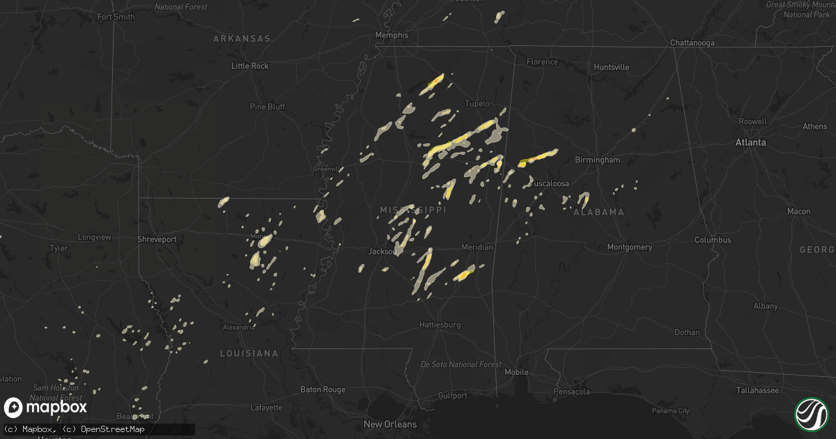
Hail Map in Mississippi on June 9, 2014
Get this storm
June 9 map
$229
one time, instant access
Download today. No call, no setup
Keep the $229
Bought the map and want the full workflow? Apply the entire $229 to a subscription within 7 days. None of it is wasted.
Every map, not just this one
This buys you this map. Subscription and you get every map we run, in the markets you choose from a few cities to whole states to nationwide. Plus real-time alerts the moment a storm fires.
Contact data
Name, contact info, occupancy, even credit band for addresses in the footprint. You go from where it hit to who to call.
Become the source they trust
Unlimited branding weather history reports on demand. You already have the documented answer ready for the property owner, and you are the one who showed up with it.
Property data and RoofTrace estimates
Pull up any address you have got, its value and the exact code rules for that jurisdiction, straight from One Click Code. Then RoofTrace estimates the squares, pitch, and roof value, priced the way you price.
Storm reports in Mississippi
Mississippi
| Date | Description |
|---|---|
| 06/09/20146:45 PM CDT | Tree blown down on a house |
| 06/09/20146:45 PM CDT | Several trees down in town. |
| 06/09/20146:40 PM CDT | Pea sized hail rapidly increased to golf ball size on highway 8. |
| 06/09/20146:35 PM CDT | Numerous trees down across roads across winston county. One tree down on a house. |
| 06/09/20146:25 PM CDT | Reports of trees down and power outages on the western portions of the county...including highway 395...county road 123...county road 397 and county road 826. |
| 06/09/20146:18 PM CDT | Trees down all across southern and eastern portions of attala county. |
| 06/09/20146:15 PM CDT | Measured by rooftop anemometer at wcbi tv |
| 06/09/20146:15 PM CDT | Numerous trees down across roads across the county. Report of some campers rolled over by wind in nw part of the county. |
| 06/09/20146:15 PM CDT | Downed trees scattered across the county |
| 06/09/20146:04 PM CDT | Golf ball sized hail near highway 349. |
| 06/09/20145:45 PM CDT | Reports of several trees down throughout the county. |
| 06/09/20145:44 PM CDT | Trees down in crossgates |
| 06/09/20145:44 PM CDT | Trees down along hwy 21 |
| 06/09/20145:38 PM CDT | Multiple trees down all across the county. |
| 06/09/20145:30 PM CDT | A few trees down along hwy 12 e |
| 06/09/20145:30 PM CDT | Reports of several trees down throughout the county. |
| 06/09/20145:30 PM CDT | Trees down |
| 06/09/20145:30 PM CDT | Reports of several trees down throughout the county. |
| 06/09/20145:28 PM CDT | A local report indicates 1.00 inch wind near LUDLOW |
| 06/09/20145:26 PM CDT | Trees downed in byram |
| 06/09/20145:25 PM CDT | Trees down along hwy 17 |
| 06/09/20145:25 PM CDT | Trees down |
| 06/09/20145:24 PM CDT | Report of quarter size hail in bellefontaine. |
| 06/09/20145:15 PM CDT | Tree down on a house. |
| 06/09/20145:15 PM CDT | Trees down |
| 06/09/20145:10 PM CDT | Large tree downed across a road...knocking down power lines |
| 06/09/20145:05 PM CDT | Reports of a powerline down on paul williams road in raymond. |
| 06/09/20144:55 PM CDT | Reports of trees and powerlines down throughout the county. |
| 06/09/20144:40 PM CDT | A few trees and power lines down. |
| 06/09/20144:40 PM CDT | Power lines down |
| 06/09/20144:34 PM CDT | A few trees and power lines down. |
| 06/09/20144:33 PM CDT | Numerous trees down around vicksburg and in the county. |
| 06/09/20144:30 PM CDT | Large tree downed across a road...knocking down power lines |
| 06/09/20144:30 PM CDT | Report of quarter size hail west of mize. |
| 06/09/20144:15 PM CDT | Reports of trees down on old highway 61 and powerlines down on highway 438 in arcola. |
| 06/09/20144:05 PM CDT | Several trees down in mayersville and across the county per sheriffs office. |
| 06/08/20147:50 PM CDT | Several trees down and power lines down...many along and over highway 345. |
| 06/08/20147:47 PM CDT | Trees down on west side of burnsville. |
| 06/08/20147:45 PM CDT | Reports of trees down on highway 513 and powerline down on county road 3541. |
| 06/08/20147:43 PM CDT | A local report indicates 1.00 inch wind near MACON |
| 06/08/20147:38 PM CDT | A local report indicates 1.75 inch wind near NEW HOPE |
| 06/08/20147:26 PM CDT | Trees and power lines down in thrasher. |
| 06/08/20147:20 PM CDT | Trees down near highway 9. Still being cleared from the road. |
| 06/08/20147:15 PM CDT | Measured by rooftop anemometer at wcbi tv |
| 06/08/20147:15 PM CDT | Trees and powerlines down countywide. Trees on a couple of houses in columbus. |
| 06/08/20147:14 PM CDT | A local report indicates 1.00 inch wind near 1 N AMORY |
| 06/08/20147:13 PM CDT | Occurred near the vossburg community |
| 06/08/20147:05 PM CDT | Reports of trees down and power outages throughout the county. |
All States Impacted by Hail Map on June 9, 2014
Cities Impacted by Hail Map on June 9, 2014
- Sardis, TN
- Enville, TN
- Milledgeville, TN
- Morris Chapel, TN
- Seagrove, NC
- Asheboro, NC
- Norway, SC
- Denmark, SC
- Cope, SC
- Mangham, LA
- Turner, MT
- Bowman, SC
- Harleyville, SC
- Dorchester, SC
- Saint George, SC
- Meyersville, TX
- Goliad, TX
- Yorktown, TX
- West Point, MS
- Houston, MS
- Muldoon, TX
- La Grange, TX
- Fayette, AL
- Kennedy, AL
- Thomasville, NC
- Trinity, NC
- Potts Camp, MS
- Abbeville, MS
- Hickory Flat, MS
- Oxford, MS
- Fayetteville, TX
- Eupora, MS
- Chatham, LA
- Fort Lauderdale, FL
- Columbus, MS
- Victoria, TX
- Boligee, AL
- Lena, MS
- Walnut Grove, MS
- Forest, MS
- Schulenburg, TX
- Weimar, TX
- Zavalla, TX
- Denton, NC
- Troy, NC
- Star, NC
- Magee, MS
- Mantee, MS
- Bellefontaine, MS
- Okolona, MS
- Amory, MS
- Aberdeen, MS
- Raleigh, MS
- Lake, MS
- Ocala, FL
- Summerfield, FL
- Indianola, MS
- Greenwood Springs, MS
- Spearsville, LA
- Lillie, LA
- Canton, MS
- Camden, MS
- Houlka, MS
- Smithville, MS
- Fulton, MS
- Tremont, MS
- Deville, LA
- Leesville, LA
- Anacoco, LA
- Shelbyville, TX
- Bay Springs, MS
- Stringer, MS
- Charleston, MS
- Sylacauga, AL
- Childersburg, AL
- Cedarbluff, MS
- Oakland, MS
- Vicksburg, MS
- Kissimmee, FL
- Monroe, LA
- Livingston, AL
- Cleveland, TX
- Ethelsville, AL
- Carrollton, AL
- Chinook, MT
- Hogeland, MT
- Winnfield, LA
- Estero, FL
- Columbia, LA
- West Monroe, LA
- Grayson, LA
- Orangeburg, SC
- Cordova, SC
- Many, LA
- Belmont, LA
- Hallettsville, TX
- Pheba, MS
- Mathiston, MS
- Maben, MS
- Vidor, TX
- Orange, TX
- Benton, MS
- Shuqualak, MS
- Gordo, AL
- Millport, AL
- Reform, AL
- Broaddus, TX
- Clermont, FL
- Edna, TX
- Louise, TX
- Sheridan, TX
- Sublime, TX
- Ganado, TX
- Garwood, TX
- Sallis, MS
- Bunnell, FL
- Taylorsville, MS
- Woodland, MS
- Stewart, MS
- Prairie, MS
- Kilmichael, MS
- Livingston, TX
- Starkville, MS
- Goodman, MS
- Pickens, MS
- Kaufman, TX
- Kemp, TX
- Lake Providence, LA
- Transylvania, LA
- Rolling Fork, MS
- Mayersville, MS
- Fairmont, NC
- Lumberton, NC
- Rowland, NC
- Berry, AL
- Ashville, AL
- Steele, AL
- Mendenhall, MS
- Belleview, FL
- Ackerman, MS
- Weir, MS
- French Camp, MS
- Ethel, MS
- Vaiden, MS
- Oakland, TX
- Benoit, MS
- Corinth, MS
- Burkeville, TX
- Brent, AL
- Centreville, AL
- Duncanville, AL
- Eutaw, AL
- Coldspring, TX
- Shepherd, TX
- Louisville, MS
- Utica, MS
- Brandon, MS
- Pelahatchie, MS
- Sardis, MS
- Batesville, MS
- Dry Creek, LA
- Grant, LA
- Sugartown, LA
- Talladega, AL
- Milam, TX
- Pontotoc, MS
- Henderson, TX
- Whiteville, TN
- Somerville, TN
- Gadsden, AL
- Collins, MS
- Marthaville, LA
- Robeline, LA
- Lufkin, TX
- Diboll, TX
- Noxapater, MS
- McCool, MS
- Aimwell, LA
- Steens, MS
- Waldo, FL
- Beaumont, TX
- Downsville, LA
- Pineville, LA
- Bamberg, SC
- Palacios, TX
- Florien, LA
- Tillatoba, MS
- Cascilla, MS
- Glendora, MS
- Minter City, MS
- Aliceville, AL
- Brooksville, MS
- Crawford, MS
- Artesia, MS
- Vossburg, MS
- Stonewall, MS
- Paulding, MS
- Heidelberg, MS
- Enterprise, MS
- Pachuta, MS
- Quitman, MS
- Bradley, SC
- Florence, MS
- Salley, SC
- Water Valley, MS
- Courtland, MS
- Pope, MS
- Conroe, TX
- Carthage, MS
- Kosciusko, MS
- Brierfield, AL
- Rose Hill, MS
- Fort Payne, AL
- Gore Springs, MS
- Duck Hill, MS
- Bastrop, LA
- Rockdale, TX
- Thorndale, TX
- Morton, MS
- Flowood, MS
- Chatham, MS
- Greenville, MS
- Glen Allan, MS
- Mize, MS
- Louin, MS
- Oak Ridge, LA
- Lexington, TX
- Lawley, AL
- Randolph, AL
- West Blocton, AL
- Onalaska, TX
- Alto, TX
- Philadelphia, MS
- Macon, MS
- Sulligent, AL
- Caledonia, MS
- Hamilton, MS
- Yoakum, TX
- Bernice, LA
- Junction City, AR
- Randolph, MS
- Myrtle, MS
- Mount Olive, MS
- Pulaski, MS
- Calhoun City, MS
- Vardaman, MS
- Marion, AL
- Evans, LA
- New Albany, MS
- Fort Lawn, SC
- Doddsville, MS
- Honea Path, SC
- Donalds, SC
- Kershaw, SC
- Deridder, LA
- Troy, SC
- Manning, SC
- Newellton, LA
- Jones, LA
- Hawthorne, FL
- Sophia, NC
- Pittsboro, MS
- Baskin, LA
- Rayville, LA
- Winnsboro, LA
- Fosters, AL
- Hornbeck, LA
- Dime Box, TX
- Caldwell, TX
- Neeses, SC
- Blackville, SC
- Brookeland, TX
- Wiergate, TX
- Noble, LA
- Winter Garden, FL
- Preston, MS
- Sunflower, MS
- Grenada, MS
- Jasper, TX
- Madison, MS
- Humble, TX
- Spring, TX
- Rowesville, SC
- Banner, MS
- Bruce, MS
- Apple Springs, TX
- Groveton, TX
- Crockett, TX
- Saint Joseph, LA
- Akron, AL
- Moundville, AL
- Pelion, SC
- Gaston, SC
- Leland, MS
- Buna, TX
- Columbus, TX
- New Waverly, TX
- Pollock, LA
- The Villages, FL
- Schlater, MS
- Knoxville, AL
- Ralph, AL
- Jonesville, LA
- Ocklawaha, FL
- Shelby, AL
- Eastover, SC
- Gadsden, SC
- Columbiana, AL
- Pembroke, NC
- Kennard, TX
- Naples, FL
- Parkin, AR
- Wynne, AR
- Pollok, TX
- Wells, TX
- Saratoga, TX
- Kelly, LA
- Olla, LA
- Adamsville, TN
- Saltillo, TN
- Valley Park, MS
- Harrisonburg, LA
- Farmerville, LA
- Etta, MS
- Bronson, TX
- Pineland, TX
- Eros, LA
- Calhoun, LA
- Scobey, MS
- Hollandale, MS
- Center Point, LA


