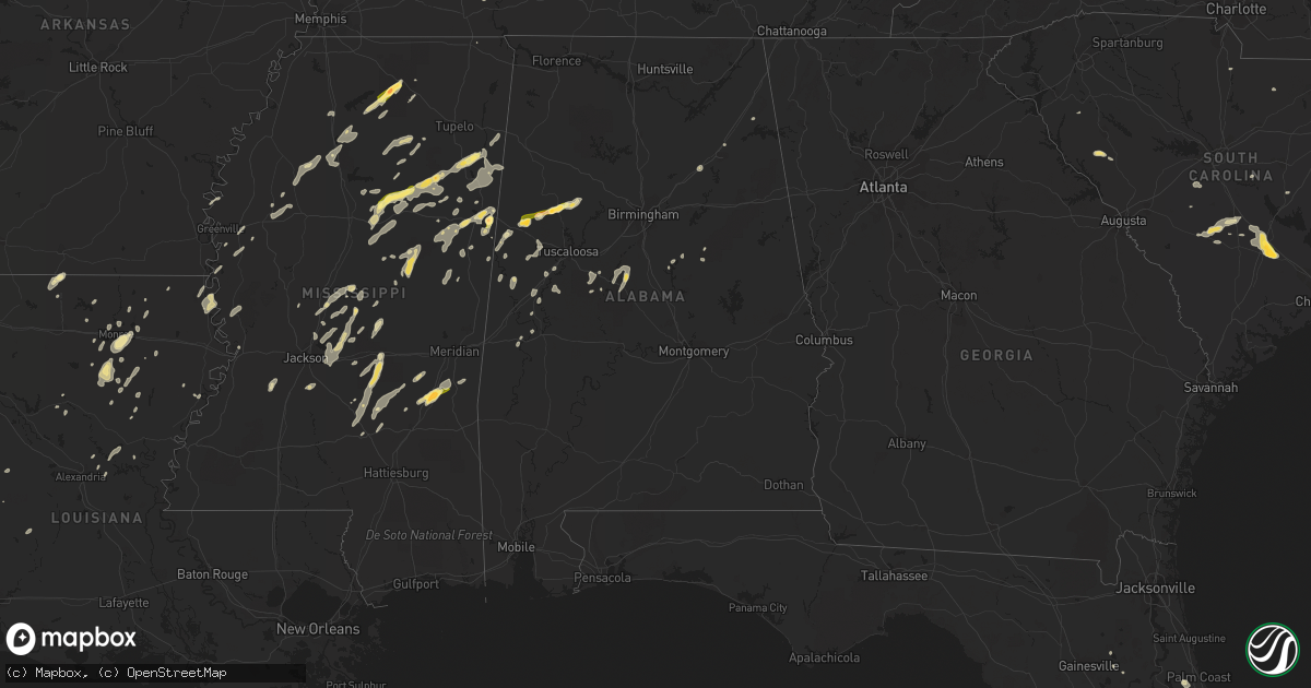
Hail Map in Alabama on June 9, 2014
Get this storm
June 9 map
$229
one time, instant access
Download today. No call, no setup
Keep the $229
Bought the map and want the full workflow? Apply the entire $229 to a subscription within 7 days. None of it is wasted.
Every map, not just this one
This buys you this map. Subscription and you get every map we run, in the markets you choose from a few cities to whole states to nationwide. Plus real-time alerts the moment a storm fires.
Contact data
Name, contact info, occupancy, even credit band for addresses in the footprint. You go from where it hit to who to call.
Become the source they trust
Unlimited branding weather history reports on demand. You already have the documented answer ready for the property owner, and you are the one who showed up with it.
Property data and RoofTrace estimates
Pull up any address you have got, its value and the exact code rules for that jurisdiction, straight from One Click Code. Then RoofTrace estimates the squares, pitch, and roof value, priced the way you price.
Storm reports in Alabama
Alabama
| Date | Description |
|---|---|
| 06/08/201411:30 PM CDT | Tree down on highway. |
| 06/08/201411:13 PM CDT | Tree down on highway. |
| 06/08/201410:04 PM CDT | Trees down along huffman road near 5 mile creek. |
| 06/08/201410:00 PM CDT | A tree was reported down across the road. |
| 06/08/20149:56 PM CDT | A tree was reported down on powerlines. |
| 06/08/20149:55 PM CDT | Trees down along huffman road near 5 mile creek. |
| 06/08/20149:45 PM CDT | Trees were blocking miller lane and james road. |
| 06/08/20149:43 PM CDT | A tree was reported down across the road. |
| 06/08/20149:42 PM CDT | A tree was blown down on olive drive. |
| 06/08/20149:22 PM CDT | A tree was blown down. |
| 06/08/20149:13 PM CDT | Trees were down in cordova. |
| 06/08/20149:10 PM CDT | Thunderstorm winds downed several trees and powerlines. |
| 06/08/20149:10 PM CDT | Trees down and barn destroyed. |
| 06/08/20149:10 PM CDT | Thunderstorm winds downed several trees and a transformer was blown near athens. |
| 06/08/20149:02 PM CDT | A tree was blown down on cr 1069. |
| 06/08/20149:00 PM CDT | Thunderstorm winds downed a few trees. |
| 06/08/20148:53 PM CDT | Trees reported down on highway 101 at state line road with road closed |
| 06/08/20148:49 PM CDT | Tree down blocking highway 140 near the buhl elementary school. |
| 06/08/20148:45 PM CDT | A few trees were downed by thunderstorm winds. |
| 06/08/20148:44 PM CDT | Tree down on car on mormon road near macedonia church. |
| 06/08/20148:37 PM CDT | Trees down along county road 63 south of berry. |
| 06/08/20148:30 PM CDT | Thunderstorm winds downed numerous trees and extensively damaged a county school bus barn. |
| 06/08/20148:30 PM CDT | Ef-1 with estimated peak wind speed of 105 ph. Path length of 5.9 miles. Maximum path width of 150 yards. |
| 06/08/20148:30 PM CDT | Trees were reported down in nauvoo. |
| 06/08/20148:30 PM CDT | Thunderstorm winds downed a tree. |
| 06/08/20148:30 PM CDT | Trees were reported down on tombigbee street. |
| 06/08/20148:30 PM CDT | Trees were reported down on tombigbee street. |
| 06/08/20148:29 PM CDT | Several trees were downed by thunderstorm winds. |
| 06/08/20148:25 PM CDT | Thunderstorm winds downed a tree. |
| 06/08/20148:25 PM CDT | Several trees were downed by thunderstorm winds. |
| 06/08/20148:25 PM CDT | Thunderstorm winds downed a tree. |
| 06/08/20148:20 PM CDT | Thunderstorm winds downed a tree. |
| 06/08/20148:18 PM CDT | Estimated in downtown haleyville. |
| 06/08/20147:54 PM CDT | Mobile home overturned near county road 25 and highway 19 in western marion county. |
| 06/08/20147:54 PM CDT | Partial roof removed from church along highway 119 north near county road 11 in barnesville. |
| 06/08/20147:51 PM CDT | Near highway 171 in far northwest tuscaloosa county. |
| 06/08/20147:47 PM CDT | A local report indicates 1.50 inch wind near 5 E ASHCRAFT CORNER |
| 06/08/20147:46 PM CDT | Trees down blocking highway 278 in beaverton. |
| 06/08/20147:46 PM CDT | A local report indicates 1.50 inch wind near 7 NE REFORM |
| 06/08/20147:45 PM CDT | Trees were blown down in the barnesville community. |
| 06/08/20147:36 PM CDT | Trees were reported down across the northern portion of the county... From the lamar county airport north to the county line. |
| 06/08/20147:35 PM CDT | Measured in downtown vernon. |
All States Impacted by Hail Map on June 9, 2014
Cities Impacted by Hail Map on June 9, 2014
- Sardis, TN
- Enville, TN
- Milledgeville, TN
- Morris Chapel, TN
- Seagrove, NC
- Asheboro, NC
- Norway, SC
- Denmark, SC
- Cope, SC
- Mangham, LA
- Turner, MT
- Bowman, SC
- Harleyville, SC
- Dorchester, SC
- Saint George, SC
- Meyersville, TX
- Goliad, TX
- Yorktown, TX
- West Point, MS
- Houston, MS
- Muldoon, TX
- La Grange, TX
- Fayette, AL
- Kennedy, AL
- Thomasville, NC
- Trinity, NC
- Potts Camp, MS
- Abbeville, MS
- Hickory Flat, MS
- Oxford, MS
- Fayetteville, TX
- Eupora, MS
- Chatham, LA
- Fort Lauderdale, FL
- Columbus, MS
- Victoria, TX
- Boligee, AL
- Lena, MS
- Walnut Grove, MS
- Forest, MS
- Schulenburg, TX
- Weimar, TX
- Zavalla, TX
- Denton, NC
- Troy, NC
- Star, NC
- Magee, MS
- Mantee, MS
- Bellefontaine, MS
- Okolona, MS
- Amory, MS
- Aberdeen, MS
- Raleigh, MS
- Lake, MS
- Ocala, FL
- Summerfield, FL
- Indianola, MS
- Greenwood Springs, MS
- Spearsville, LA
- Lillie, LA
- Canton, MS
- Camden, MS
- Houlka, MS
- Smithville, MS
- Fulton, MS
- Tremont, MS
- Deville, LA
- Leesville, LA
- Anacoco, LA
- Shelbyville, TX
- Bay Springs, MS
- Stringer, MS
- Charleston, MS
- Sylacauga, AL
- Childersburg, AL
- Cedarbluff, MS
- Oakland, MS
- Vicksburg, MS
- Kissimmee, FL
- Monroe, LA
- Livingston, AL
- Cleveland, TX
- Ethelsville, AL
- Carrollton, AL
- Chinook, MT
- Hogeland, MT
- Winnfield, LA
- Estero, FL
- Columbia, LA
- West Monroe, LA
- Grayson, LA
- Orangeburg, SC
- Cordova, SC
- Many, LA
- Belmont, LA
- Hallettsville, TX
- Pheba, MS
- Mathiston, MS
- Maben, MS
- Vidor, TX
- Orange, TX
- Benton, MS
- Shuqualak, MS
- Gordo, AL
- Millport, AL
- Reform, AL
- Broaddus, TX
- Clermont, FL
- Edna, TX
- Louise, TX
- Sheridan, TX
- Sublime, TX
- Ganado, TX
- Garwood, TX
- Sallis, MS
- Bunnell, FL
- Taylorsville, MS
- Woodland, MS
- Stewart, MS
- Prairie, MS
- Kilmichael, MS
- Livingston, TX
- Starkville, MS
- Goodman, MS
- Pickens, MS
- Kaufman, TX
- Kemp, TX
- Lake Providence, LA
- Transylvania, LA
- Rolling Fork, MS
- Mayersville, MS
- Fairmont, NC
- Lumberton, NC
- Rowland, NC
- Berry, AL
- Ashville, AL
- Steele, AL
- Mendenhall, MS
- Belleview, FL
- Ackerman, MS
- Weir, MS
- French Camp, MS
- Ethel, MS
- Vaiden, MS
- Oakland, TX
- Benoit, MS
- Corinth, MS
- Burkeville, TX
- Brent, AL
- Centreville, AL
- Duncanville, AL
- Eutaw, AL
- Coldspring, TX
- Shepherd, TX
- Louisville, MS
- Utica, MS
- Brandon, MS
- Pelahatchie, MS
- Sardis, MS
- Batesville, MS
- Dry Creek, LA
- Grant, LA
- Sugartown, LA
- Talladega, AL
- Milam, TX
- Pontotoc, MS
- Henderson, TX
- Whiteville, TN
- Somerville, TN
- Gadsden, AL
- Collins, MS
- Marthaville, LA
- Robeline, LA
- Lufkin, TX
- Diboll, TX
- Noxapater, MS
- McCool, MS
- Aimwell, LA
- Steens, MS
- Waldo, FL
- Beaumont, TX
- Downsville, LA
- Pineville, LA
- Bamberg, SC
- Palacios, TX
- Florien, LA
- Tillatoba, MS
- Cascilla, MS
- Glendora, MS
- Minter City, MS
- Aliceville, AL
- Brooksville, MS
- Crawford, MS
- Artesia, MS
- Vossburg, MS
- Stonewall, MS
- Paulding, MS
- Heidelberg, MS
- Enterprise, MS
- Pachuta, MS
- Quitman, MS
- Bradley, SC
- Florence, MS
- Salley, SC
- Water Valley, MS
- Courtland, MS
- Pope, MS
- Conroe, TX
- Carthage, MS
- Kosciusko, MS
- Brierfield, AL
- Rose Hill, MS
- Fort Payne, AL
- Gore Springs, MS
- Duck Hill, MS
- Bastrop, LA
- Rockdale, TX
- Thorndale, TX
- Morton, MS
- Flowood, MS
- Chatham, MS
- Greenville, MS
- Glen Allan, MS
- Mize, MS
- Louin, MS
- Oak Ridge, LA
- Lexington, TX
- Lawley, AL
- Randolph, AL
- West Blocton, AL
- Onalaska, TX
- Alto, TX
- Philadelphia, MS
- Macon, MS
- Sulligent, AL
- Caledonia, MS
- Hamilton, MS
- Yoakum, TX
- Bernice, LA
- Junction City, AR
- Randolph, MS
- Myrtle, MS
- Mount Olive, MS
- Pulaski, MS
- Calhoun City, MS
- Vardaman, MS
- Marion, AL
- Evans, LA
- New Albany, MS
- Fort Lawn, SC
- Doddsville, MS
- Honea Path, SC
- Donalds, SC
- Kershaw, SC
- Deridder, LA
- Troy, SC
- Manning, SC
- Newellton, LA
- Jones, LA
- Hawthorne, FL
- Sophia, NC
- Pittsboro, MS
- Baskin, LA
- Rayville, LA
- Winnsboro, LA
- Fosters, AL
- Hornbeck, LA
- Dime Box, TX
- Caldwell, TX
- Neeses, SC
- Blackville, SC
- Brookeland, TX
- Wiergate, TX
- Noble, LA
- Winter Garden, FL
- Preston, MS
- Sunflower, MS
- Grenada, MS
- Jasper, TX
- Madison, MS
- Humble, TX
- Spring, TX
- Rowesville, SC
- Banner, MS
- Bruce, MS
- Apple Springs, TX
- Groveton, TX
- Crockett, TX
- Saint Joseph, LA
- Akron, AL
- Moundville, AL
- Pelion, SC
- Gaston, SC
- Leland, MS
- Buna, TX
- Columbus, TX
- New Waverly, TX
- Pollock, LA
- The Villages, FL
- Schlater, MS
- Knoxville, AL
- Ralph, AL
- Jonesville, LA
- Ocklawaha, FL
- Shelby, AL
- Eastover, SC
- Gadsden, SC
- Columbiana, AL
- Pembroke, NC
- Kennard, TX
- Naples, FL
- Parkin, AR
- Wynne, AR
- Pollok, TX
- Wells, TX
- Saratoga, TX
- Kelly, LA
- Olla, LA
- Adamsville, TN
- Saltillo, TN
- Valley Park, MS
- Harrisonburg, LA
- Farmerville, LA
- Etta, MS
- Bronson, TX
- Pineland, TX
- Eros, LA
- Calhoun, LA
- Scobey, MS
- Hollandale, MS
- Center Point, LA


