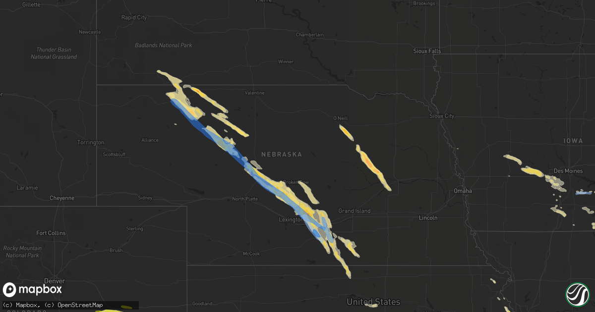
Hail Map in Nebraska on June 6, 2022
Get this storm
June 6 map
$229
one time, instant access
Download today. No call, no setup
Keep the $229
Bought the map and want the full workflow? Apply the entire $229 to a subscription within 7 days. None of it is wasted.
Every map, not just this one
This buys you this map. Subscription and you get every map we run, in the markets you choose from a few cities to whole states to nationwide. Plus real-time alerts the moment a storm fires.
Contact data
Name, contact info, occupancy, even credit band for addresses in the footprint. You go from where it hit to who to call.
Become the source they trust
Unlimited branding weather history reports on demand. You already have the documented answer ready for the property owner, and you are the one who showed up with it.
Property data and RoofTrace estimates
Pull up any address you have got, its value and the exact code rules for that jurisdiction, straight from One Click Code. Then RoofTrace estimates the squares, pitch, and roof value, priced the way you price.
Storm reports in Nebraska
Nebraska
| Date | Description |
|---|---|
| 06/06/20226:55 PM CDT | A local report indicates 1.75 inch wind near 23 SSE GORDON |
| 06/06/20226:40 PM CDT | Via spotternetwork.org |
| 06/06/20226:37 PM CDT | Via spotternetwork.org |
| 06/06/20226:20 PM CDT | Via twitter. |
| 06/06/20225:34 PM CDT | Report via twitter |
| 06/06/20225:00 PM CDT | A local report indicates 1.75 inch wind near 9 SW MERRIMAN |
| 06/06/20224:59 PM CDT | Via spotternetwork.org |
| 06/06/20224:34 PM CDT | Via spotternetwork.org |
| 06/06/20224:30 PM CDT | Golf ball sized hail. Shredded trees. |
| 06/06/20223:24 PM CDT | Report via twitter. |
| 06/06/20223:24 PM CDT | Report via twitter. |
| 06/06/20223:18 PM CDT | Hail not quite golf ball size reported. |
| 06/06/20223:13 PM CDT | Overturned center pivot. |
| 06/06/20223:09 PM CDT | Accompanied by strong wind. |
| 06/06/20222:54 PM CDT | A local report indicates 1.50 inch wind near ALBION |
| 06/06/20222:52 PM CDT | 1.5 inch hail and winds 50 to 60 mph. |
| 06/06/20222:52 PM CDT | Hail to 1.5 inches in diameter and 50 to 60 mph wind. |
| 06/06/20222:52 PM CDT | Delayed report. |
| 06/06/20222:49 PM CDT | Late report. |
| 06/06/20222:47 PM CDT | Gordon rushville fire department reported a landspout tornado briefly touching down. |
| 06/06/20222:35 PM CDT | A local report indicates 1.25 inch wind near 2 SW PETERSBURG |
| 06/06/20222:33 PM CDT | Hail to at least golf ball size shattered a police vehicle windshield and one side window. |
| 06/06/20222:29 PM CDT | Significant tree and crop damage from golf ball size hail. Hail covering the ground. |
| 06/06/20222:29 PM CDT | Spotter reported watching a tornado quickly develop and damage a center pivot irrigation system. Also noted ample amounts of golfball size hail. |
| 06/06/20222:28 PM CDT | Hail just began. Quarter size hail so far. |
| 06/06/20227:13 AM CDT | At 1212 AM MDT, a severe thunderstorm was located 9 miles south of Barton, or 9 miles southeast of Julesburg, moving southeast at 35 mph. HAZARD...60 mph wind gusts and quarter size hail. SOURCE...Radar indicated. IMPACT...Expect damage to roofs, siding, and trees. Hail damage to vehicles is expected. This severe thunderstorm will remain over mainly rural areas of east central Sedgwick County. |
| 06/06/20226:24 AM CDT | At 1124 PM CDT, a severe thunderstorm was located near Kearney, moving southeast at 40 mph. HAZARD...60 mph wind gusts and nickel size hail. SOURCE...Radar indicated. IMPACT...Expect damage to roofs, siding, and trees. This severe thunderstorm will be near... Minden around 1140 PM CDT.Other locations in the path of this severe thunderstorm includeHeartwell and Norman.This includes Interstate 80 between mile markers 267 and 287. |
| 06/06/20225:42 AM CDT | At 1042 PM CDT, a severe thunderstorm was located over Sumner, or 15 miles northeast of Lexington, moving southeast at 50 mph. HAZARD...60 mph wind gusts and quarter size hail. SOURCE...Radar indicated. IMPACT...Hail damage to vehicles is expected. Expect wind damage to roofs, siding, and trees. This severe thunderstorm will be near... Miller around 1045 PM CDT. Amherst around 1055 PM CDT. Elm Creek around 1100 PM CDT.Other locations in the path of this severe thunderstorm includeOdessa, Riverdale and Kearney.This includes Interstate 80 between mile markers 251 and 291. |
| 06/06/20225:05 AM CDT | At 1005 PM CDT, a severe thunderstorm was located 7 miles west of Oconto, or 24 miles southwest of Broken Bow, moving southeast at 50 mph. HAZARD...60 mph wind gusts and quarter size hail. SOURCE...Radar indicated. IMPACT...Hail damage to vehicles is expected. Expect wind damage to roofs, siding, and trees. This severe thunderstorm will be near... Eddyville around 1025 PM CDT.Other locations in the path of this severe thunderstorm includeSumner, Miller and Amherst.This includes Interstate 80 between mile markers 229 and 267. |
| 06/06/20224:12 AM CDT | At 912 PM CDT, a severe thunderstorm was located near Stapleton, moving southeast at 45 mph. HAZARD...70 mph wind gusts and ping pong ball size hail. SOURCE...Radar indicated. IMPACT...People and animals outdoors will be injured. Expect hail damage to roofs, siding, windows, and vehicles. Expect considerable tree damage. Wind damage is also likely to mobile homes, roofs, and outbuildings. Locations impacted include... Stapleton, Arnold, Callaway, Oconto, Gandy, Logan, Etna, Milldale, Burr Oak, Lodi, Buckeye, Shanklin Bluff, Tarboz Lake, Pleasant Hill, Hoagland, Brown Lake, Finchville and Cumro.This includes the following highways... Highway 183 between mile markers 73 and 79. Highway 92 between mile markers 219 and 262. Highway 83 between mile markers 103 and 124. |
| 06/06/20223:18 AM CDT | At 818 PM CDT, severe thunderstorms were located along a line extending from Heartwell to near Minden to Axtell, moving southeast at 35 mph. HAZARD...60 mph wind gusts and quarter size hail. SOURCE...Radar indicated. IMPACT...Hail damage to vehicles is expected. Expect wind damage to roofs, siding, and trees. Severe thunderstorms will be near... Norman around 830 PM CDT. Hildreth and Holstein around 835 PM CDT.Other locations in the path of these severe thunderstorms includeRoseland and Upland. |
| 06/06/20223:04 AM CDT | At 804 PM CDT, severe thunderstorms were located along a line extending from near Gibbon to 7 miles southeast of Kearney to 6 miles northwest of Axtell, moving southeast at 35 mph. HAZARD...60 mph wind gusts and quarter size hail. SOURCE...Radar indicated. IMPACT...Hail damage to vehicles is expected. Expect wind damage to roofs, siding, and trees. Severe thunderstorms will be near... Axtell and Heartwell around 815 PM CDT. Minden and Kenesaw around 820 PM CDT.Other locations in the path of these severe thunderstorms includeWilcox, Hildreth, Roseland, Holstein and Norman.This includes Interstate 80 between mile markers 275 and 287. |
| 06/06/20222:47 AM CDT | At 747 PM CDT/647 PM MDT/, a severe thunderstorm was located 13 miles northeast of Whitman, or 18 miles northwest of Mullen, moving southeast at 45 mph. HAZARD...Ping pong ball size hail and 60 mph wind gusts. SOURCE...Radar indicated. IMPACT...People and animals outdoors will be injured. Expect hail damage to roofs, siding, windows, and vehicles. Expect wind damage to roofs, siding, and trees. Locations impacted include... Mullen, Stapleton, Tryon, Gandy, Ringgold, Logan, Highway 83 crossing The Dismal River, Shanklin Bluff, Tarboz Lake, Hoagland, Brown Lake, Highway 97 crossing the Dismal River, Hecla, Weir and Shimmons Lake.This includes the following highways... Highway 2 between mile markers 167 and 186. Highway 92 between mile markers 199 and 245. Highway 97 between mile markers 17 and 68. Highway 83 between mile markers 106 and 135. |
| 06/06/20222:23 AM CDT | At 723 PM CDT, severe thunderstorms were located along a line extending from near Pleasanton to near Miller, moving southeast at 40 mph. HAZARD...60 mph wind gusts and quarter size hail. SOURCE...Radar indicated. IMPACT...Hail damage to vehicles is expected. Expect wind damage to roofs, siding, and trees. Severe thunderstorms will be near... Kearney and Elm Creek around 740 PM CDT.Other locations in the path of these severe thunderstorms includeOdessa, Riverdale, Gibbon, Kenesaw and Heartwell.This includes Interstate 80 between mile markers 252 and 292. |
| 06/06/20221:31 AM CDT | At 630 PM CDT, severe thunderstorms were located along a line extending from near Mason City to 6 miles north of Oconto, moving southeast at 30 mph. HAZARD...60 mph wind gusts and quarter size hail. SOURCE...Radar indicated. IMPACT...Hail damage to vehicles is expected. Expect wind damage to roofs, siding, and trees. Severe thunderstorms will be near... Litchfield around 650 PM CDT.Other locations in the path of these severe thunderstorms includeHazard, Eddyville, Pleasanton, Sumner and Miller. |
| 06/06/20221:26 AM CDT | At 625 PM CDT, severe thunderstorms were located along a line extending from near Ansley to near Callaway, moving southeast at 30 mph. HAZARD...60 mph wind gusts and quarter size hail. SOURCE...Radar indicated. IMPACT...Hail damage to vehicles is expected. Expect wind damage to roofs, siding, and trees. Locations impacted include... Broken Bow, Callaway, Ansley, Merna, Mason City, Oconto, Berwyn, Weissert, Westerville, Lillian, Round Valley, Walworth, Burr Oak, Gavin Siding, Lodi, Buckeye, Block Hill Basin and Gates.This includes the following highways... Highway 183 between mile markers 73 and 108. Highway 2 between mile markers 265 and 307. Highway 92 between mile markers 269 and 308. |
| 06/06/202212:57 AM CDT | At 557 PM CDT/457 PM MDT/, a severe thunderstorm was located 10 miles south of Medicine Lake, or 40 miles northwest of Mullen, moving southeast at 30 mph. HAZARD...60 mph wind gusts and quarter size hail. SOURCE...Radar indicated. IMPACT...Hail damage to vehicles is expected. Expect wind damage to roofs, siding, and trees. Locations impacted include... Highway 97 crossing the North Loup River, Indian Hill, Marsh Flat, Speckel Meir Lake, Highway 97 crossing Big Creek and Sevenmile Hill.This includes Highway 97 between mile markers 83 and 106. |
| 06/06/202212:48 AM CDT | At 548 PM MDT, severe thunderstorms were located along a line extending from 7 miles east of Gordon to 22 miles southeast of Rushville, moving southeast at 45 mph. HAZARD...Golf ball size hail and 60 mph wind gusts. SOURCE...Radar indicated. IMPACT...People and animals outdoors will be injured. Expect hail damage to roofs, siding, windows, and vehicles. Expect wind damage to roofs, siding, and trees. Locations impacted include... Speckel Meir Lake, Highway 61 crossing the Snake River, Big Hill, Dipping Vat Meadow, Morgan Lake, Intersection of Highway 20 and Irwin Road, Intersection of Highway 61 and Survey Valley Road, Rock Hill, Bayonne, Mother Lake, Round Lake, Hire, Intersection of Highway 61 and Shadbolt Road, Whitman Road crossing the North Branch of the Middle Loup River and Sevenmile Hill.This includes the following highways... Highway 20 between mile markers 113 and 122. Highway 61 between mile markers 166 and 211. |
| 06/05/202211:58 PM CDT | At 458 PM MDT, a severe thunderstorm was located 5 miles southwest of Manderson, or 10 miles north of Pine Ridge, moving southeast at 40 mph. HAZARD...60 mph wind gusts and quarter size hail. SOURCE...Radar indicated. IMPACT...Hail damage to vehicles is expected. Expect wind damage to roofs, siding, and trees. This severe thunderstorm will be near... Wounded Knee and Porcupine Butte Housing around 510 PM MDT. Wolf Creek Housing around 515 PM MDT.Other locations in the path of this severe thunderstorm includeWakpamni. |
| 06/05/202211:49 PM CDT | At 449 PM CDT, a severe thunderstorm was located near Thedford, moving southeast at 30 mph. HAZARD...60 mph wind gusts and half dollar size hail. SOURCE...Radar indicated. IMPACT...Hail damage to vehicles is expected. Expect wind damage to roofs, siding, and trees. Locations impacted include... Thedford, Halsey, Purdum and Natwick. This includes the following highways... Highway 2 between mile markers 209 and 233. Highway 83 between mile markers 143 and 162. |
| 06/05/202211:17 PM CDT | A local report indicates 60 MPH wind near AMHERST |
| 06/05/202211:16 PM CDT | At 416 PM MDT, a severe thunderstorm was located 4 miles west of Prairie Winds Casino, or 25 miles southeast of Hot Springs, moving southeast at 40 mph. HAZARD...Tennis ball size hail and 60 mph wind gusts. SOURCE...Radar indicated. IMPACT...People and animals outdoors will be injured. Expect hail damage to roofs, siding, windows, and vehicles. Expect wind damage to roofs, siding, and trees. This severe thunderstorm will be near... Prairie Winds Casino around 425 PM MDT. Slim Butte around 435 PM MDT.Other locations in the path of this severe thunderstorm include SouthLakeside, Slim Buttes Housing, Number 4, Calico, Pine Ridge and WolfCreek Housing. |
| 06/05/202211:12 PM CDT | Facebook. |
| 06/05/202211:01 PM CDT | At 401 PM CDT/301 PM MDT/, a severe thunderstorm was located 19 miles north of Mullen, moving southeast at 30 mph. HAZARD...60 mph wind gusts and quarter size hail. SOURCE...Radar indicated. IMPACT...Hail damage to vehicles is expected. Expect wind damage to roofs, siding, and trees. Locations impacted include... Seneca, Brownlee, Highway 97 crossing the North Loup River, Marsh Flat, Norway, Giant Hill, Highway 97 crossing Big Creek, Kelso and Highway 83 crossing the North Loup River.This includes the following highways... Highway 2 between mile markers 186 and 203. Highway 97 between mile markers 69 and 92. Highway 83 between mile markers 157 and 172. |
| 06/05/202210:59 PM CDT | At 359 PM MDT, a severe thunderstorm was located 8 miles southwest of Merriman, or 18 miles east of Gordon, moving southeast at 30 mph. HAZARD...60 mph wind gusts and quarter size hail. SOURCE...Radar indicated. IMPACT...Hail damage to vehicles is expected. Expect wind damage to roofs, siding, and trees. Locations impacted include... Medicine Lake, Highway 61 crossing the Snake River, Highway 61 Crossing The Niobrara River, Intersection of Highway 61 and Shadbolt Road, Indian Hill, Schoolhouse Lake and Intersection of Highway 20 and Irwin Road.This includes the following highways... Highway 20 between mile markers 118 and 133. Highway 61 between mile markers 192 and 224. |
| 06/05/202210:52 PM CDT | Corrects time of previous hail report from 2 s miller. Time estimated from radar. Report via facebook. |
| 06/05/202210:51 PM CDT | At 351 PM CDT, a severe thunderstorm was located near Osceola, or 14 miles southwest of Columbus, moving southeast at 40 mph. HAZARD...60 mph wind gusts and half dollar size hail. SOURCE...Radar indicated. IMPACT...Hail damage to vehicles is expected. Expect wind damage to roofs, siding, and trees. This severe thunderstorm will be near... Osceola around 355 PM CDT. Shelby around 400 PM CDT.Other locations in the path of this severe thunderstorm includeGresham. |
| 06/05/202210:35 PM CDT | A local report indicates 1.00 inch wind near EDDYVILLE |
| 06/05/202210:14 PM CDT | At 313 PM CDT, a severe thunderstorm was located near St. Edward, or 13 miles southeast of Albion, moving southeast at 35 mph. HAZARD...Golf ball size hail and 60 mph wind gusts. SOURCE...Radar indicated. IMPACT...People and animals outdoors will be injured. Expect hail damage to roofs, siding, windows, and vehicles. Expect wind damage to roofs, siding, and trees. Locations impacted include... Monroe and Duncan. |
| 06/05/202210:13 PM CDT | At 313 PM MDT, a severe thunderstorm was located 8 miles southwest of Batesland, or 16 miles north of Gordon, moving southeast at 30 mph. HAZARD...60 mph wind gusts and quarter size hail. SOURCE...Radar indicated. IMPACT...Hail damage to vehicles is expected. Expect wind damage to roofs, siding, and trees. Locations impacted include... Merriman, Hoover Lake, Irwin, Intersection of Highway 20 and Irwin Road, Shell Lake State Wildlife Management Area and Bayonne.This includes the following highways... Highway 20 between mile markers 113 and 138. Highway 61 between mile markers 225 and 228. |
| 06/05/202210:13 PM CDT | At 313 PM CDT, a severe thunderstorm was located near St. Edward, or 13 miles southeast of Albion, moving southeast at 35 mph. HAZARD...Golf ball size hail and 60 mph wind gusts. SOURCE...Radar indicated. IMPACT...People and animals outdoors will be injured. Expect hail damage to roofs, siding, windows, and vehicles. Expect wind damage to roofs, siding, and trees. Locations impacted include... Monroe and Duncan. |
| 06/05/202210:12 PM CDT | At 311 PM CDT, a severe thunderstorm was located over St. Edward, or 26 miles west of Columbus, moving southeast at 35 mph. HAZARD...Golf ball size hail and 60 mph wind gusts. SOURCE...Radar indicated. IMPACT...People and animals outdoors will be injured. Expect hail damage to roofs, siding, windows, and vehicles. Expect wind damage to roofs, siding, and trees. This severe thunderstorm will be near... Genoa around 330 PM CDT.Other locations in the path of this severe thunderstorm includeSilver Creek. |
| 06/05/202210:08 PM CDT | Report via twitter. |
| 06/05/20229:58 PM CDT | At 257 PM MDT, a severe thunderstorm was located near Medicine Lake, or 38 miles southeast of Martin, moving southeast at 30 mph. HAZARD...60 mph wind gusts and quarter size hail. SOURCE...Radar indicated. IMPACT...Hail damage to vehicles is expected. Expect wind damage to roofs, siding, and trees. Locations impacted include... Schoolhouse Lake and Steer Creek Campground. |
| 06/05/20229:51 PM CDT | A local report indicates 1.50 inch wind near 8 WSW CALLAWAY |
| 06/05/20229:46 PM CDT | At 245 PM CDT, a severe thunderstorm was located 3 miles northwest of Albion, moving southeast at 30 mph. HAZARD...Tennis ball size hail and 60 mph wind gusts. SOURCE...Radar indicated. At 235PM 1.25" hail was reported 2 miles SW of Petersburg. IMPACT...People and animals outdoors will be injured. Expect hail damage to roofs, siding, windows, and vehicles. Expect wind damage to roofs, siding, and trees. This severe thunderstorm will be near... Albion around 250 PM CDT.Other locations in the path of this severe thunderstorm include St.Edward. |
| 06/05/20229:41 PM CDT | Pea sized hail as well. |
| 06/05/20229:28 PM CDT | At 228 PM MDT, a severe thunderstorm was located 18 miles south of Medicine Lake, or 33 miles northwest of Mullen, moving southeast at 25 mph. HAZARD...60 mph wind gusts and quarter size hail. SOURCE...Radar indicated. IMPACT...Hail damage to vehicles is expected. Expect wind damage to roofs, siding, and trees. Locations impacted include... Highway 97 crossing the North Loup River, Marsh Flat, Speckel Meir Lake, Highway 97 crossing Big Creek and Sevenmile Hill.This includes Highway 97 between mile markers 85 and 98. |
| 06/05/20229:21 PM CDT | At 221 PM MDT, a severe thunderstorm was located 9 miles south of Merriman, or 26 miles south of Martin, moving southeast at 30 mph. HAZARD...60 mph wind gusts and quarter size hail. SOURCE...Radar indicated. IMPACT...Hail damage to vehicles is expected. Expect wind damage to roofs, siding, and trees. Locations impacted include... Medicine Lake, Highway 61 Crossing The Niobrara River, Intersection of Highway 61 and Shadbolt Road, Indian Hill and Schoolhouse Lake.This includes Highway 61 between mile markers 201 and 219. |
| 06/05/20229:21 PM CDT | At 221 PM CDT, a severe thunderstorm was located 4 miles northwest of Petersburg, or 15 miles northwest of Albion, moving southeast at 30 mph. HAZARD...60 mph wind gusts and half dollar size hail. SOURCE...Radar indicated. IMPACT...Hail damage to vehicles is expected. Expect wind damage to roofs, siding, and trees. This severe thunderstorm will be near... Petersburg around 230 PM CDT.Other locations in the path of this severe thunderstorm includeAlbion. |
| 06/05/20228:57 PM CDT | Power pole snapped... Trees down... Large limbs down. |
| 06/05/20228:56 PM CDT | Pivot flipped and 8 inch tree limb down. |
| 06/05/20228:54 PM CDT | Garage blown down... Large tree limbs down... Trampoline flipped...facebook photos. |
| 06/05/20228:52 PM CDT | At 151 PM CDT, a severe thunderstorm was located 10 miles southwest of Clearwater, or 16 miles west of Neligh, moving southeast at 30 mph. HAZARD...60 mph wind gusts and half dollar size hail. SOURCE...Radar indicated. IMPACT...Hail damage to vehicles is expected. Expect wind damage to roofs, siding, and trees. Locations impacted include... Petersburg. |
| 06/05/20228:45 PM CDT | At 144 AM MDT, a severe thunderstorm was located near Alliance, moving southeast at 50 mph. HAZARD...Golf ball size hail and 60 mph wind gusts. SOURCE...Radar indicated. IMPACT...People and animals outdoors will be injured. Expect hail damage to roofs, siding, windows, and vehicles. Expect wind damage to roofs, siding, and trees. Locations impacted include... Alliance, Alliance Airport and Berea. This replaces the Severe Thunderstorm Warning which was previously in effect for the warned area. |
| 06/05/20228:37 PM CDT | Corrects previous tstm wnd dmg report from 4 w campbell. Power pole snapped... Trees down... Large limbs down. |
| 06/05/20228:35 PM CDT | Via twitter. |
| 06/05/20228:30 PM CDT | 4 telephone poles down. |
| 06/05/20228:20 PM CDT | At 119 PM CDT, a severe thunderstorm was located 10 miles northeast of Chambers, or 13 miles south of O'neill, moving southeast at 30 mph. HAZARD...60 mph wind gusts and quarter size hail. SOURCE...Radar indicated. IMPACT...Hail damage to vehicles is expected. Expect wind damage to roofs, siding, and trees. Locations impacted include... Knievels Corner and Goose Lake State Wildlife Management Area. This includes Highway 281 between mile markers 163 and 173. |
| 06/05/20228:10 PM CDT | Report via twitter. |
| 06/05/20228:10 PM CDT | Accompanied by strong winds. Went to basement for shelter. |
| 06/05/20228:10 PM CDT | A local report indicates 60 MPH wind near 5 SSE ODESSA |
| 06/05/20228:10 PM CDT | A local report indicates 1.00 inch wind near AXTELL |
| 06/05/20228:10 PM CDT | A local report indicates 1.50 inch wind near 10 W MULLEN |
| 06/05/20228:10 PM CDT | Corrects previous tstm wnd dmg report from axtell. Garage blown down... Large tree limbs down... Trampoline flipped...facebook photos. |
| 06/05/20228:10 PM CDT | Corrects previous tstm wnd dmg report from 1 ne minden. Pivot flipped and 8 inch tree limb down. |
| 06/05/20228:09 PM CDT | Corrects previous non-tstm wnd dmg report from 3 nne minden. Multiple large transmission towers downed from apparent straight line winds. Also numerous damaged pivots i |
| 06/05/20228:09 PM CDT | Corrects previous tstm wnd dmg report from 4 ne minden. 4 telephone poles down. |
| 06/05/20228:03 PM CDT | A local report indicates 79 MPH wind near 5 N AXTELL |
| 06/05/20228:02 PM CDT | At 102 AM MDT, a severe thunderstorm was located near Flahertys Corner, or 30 miles northwest of Alliance, moving southeast at 45 mph. HAZARD...Ping pong ball size hail and 60 mph wind gusts. SOURCE...Radar indicated. IMPACT...People and animals outdoors will be injured. Expect hail damage to roofs, siding, windows, and vehicles. Expect wind damage to roofs, siding, and trees. Locations impacted include... Hemingford, Berea, Kilpatrick Lake and Flahertys Corner. |
| 06/05/20228:00 PM CDT | Corrects previous tstm wnd gst report from 5 sse odessa. |
| 06/05/20227:59 PM CDT | A local report indicates 59 MPH wind near 3 ESE KEARNEY |
| 06/05/20227:50 PM CDT | A local report indicates 61 MPH wind near KEARNEY AIRPORT |
| 06/05/20227:45 PM CDT | A local report indicates 1.00 inch wind near ODESSA |
| 06/05/20227:43 PM CDT | 3 pivots turned over... Time estimated from radar. |
| 06/05/20227:43 PM CDT | Pivot turned over... Time estimated from radar. |
| 06/05/20227:12 PM CDT | A local report indicates 1.00 inch wind near EDDYVILLE |
All States Impacted by Hail Map on June 6, 2022
Cities Impacted by Hail Map on June 6, 2022
- Menlo, IA
- Adair, IA
- Casey, IA
- Dexter, IA
- Stuart, IA
- Earlham, IA
- Panora, IA
- Guthrie Center, IA
- Redfield, IA
- Ellsworth, NE
- Rushville, NE
- Peru, IA
- Truro, IA
- Abingdon, IL
- Galesburg, IL
- Camden, TN
- Pemberville, OH
- Hale, MO
- Chillicothe, MO
- Mendon, MO
- Sumner, MO
- Sheridan, MO
- Hopkins, MO
- Merriman, NE
- Cody, NE
- Osceola, IA
- Thedford, NE
- Valentine, NE
- Garden Grove, IA
- Van Wert, IA
- Murray, IA
- Thayer, IA
- Humeston, IA
- Weldon, IA
- Rush, CO
- Peyton, CO
- Arlington, CO
- Sugar City, CO
- Calhan, CO
- Karval, CO
- Ordway, CO
- Yoder, CO
- Cloverdale, OH
- Ottawa, OH
- Continental, OH
- Drakesville, IA
- Moulton, IA
- Bloomfield, IA
- Albion, NE
- Genoa, NE
- Elgin, NE
- Clearwater, NE
- Columbus, NE
- Osceola, NE
- Silver Creek, NE
- Saint Edward, NE
- Petersburg, NE
- Barnesville, GA
- Portageville, MO
- Wardell, MO
- Amity, MO
- Mitchell, IN
- Springville, TN
- Mansfield, TN
- Bucklin, KS
- Cottontown, TN
- Hendersonville, TN
- Hermitage, TN
- Castalian Springs, TN
- Goodlettsville, TN
- Lascassas, TN
- Bethpage, TN
- Old Hickory, TN
- Westmoreland, TN
- White House, TN
- Watertown, TN
- Lebanon, TN
- Olmstead, KY
- Gallatin, TN
- Murfreesboro, TN
- Springfield, TN
- Greenbrier, TN
- Orlinda, TN
- Red Boiling Springs, TN
- Madison, TN
- Adairville, KY
- Lafayette, TN
- Nashville, TN
- Adams, TN
- Cross Plains, TN
- Mount Juliet, TN
- Milton, TN
- Auburntown, TN
- Cedar Hill, TN
- Portland, TN
- Atlantic, IA
- Allerton, IA
- Whitman, NE
- Rock Island, IL
- Coal Valley, IL
- Milan, IL
- Moline, IL
- Green City, MO
- Kansas City, MO
- Albany, MO
- Denver, MO
- Worth, MO
- Gentry, MO
- Grant City, MO
- Troy, KS
- Robinson, KS
- Denton, KS
- Bendena, KS
- Udell, IA
- Mystic, IA
- Centerville, IA
- Penrose, CO
- Blanchard, OK
- Melcher Dallas, IA
- Milo, IA
- Knoxville, IA
- Lacona, IA
- Adolphus, KY
- Franklin, KY
- Ulysses, KS
- Johnson, KS
- Howard, KS
- Carmel, IN
- Zionsville, IN
- Westfield, IN
- Sheridan, IN
- Big Sandy, TN
- Gainesboro, TN
- Granville, TN
- Ripley, TN
- Henning, TN
- Michigan City, MS
- Ashland, MS
- Walnut, MS
- Falkner, MS
- Tiplersville, MS
- Gordon, NE
- Bussey, IA
- Tracy, IA
- Harper, KS
- Las Animas, CO
- Fayette, MO
- Armstrong, MO
- Kinsley, KS
- Ness City, KS
- Burdett, KS
- Hanston, KS
- Plant City, FL
- Liberal, KS
- Milan, MO
- Toone, TN
- Stanton, TN
- Whiteville, TN
- Fort Cobb, OK
- Callaway, NE
- Broken Bow, NE
- Dalhart, TX
- Hartley, TX
- Dumas, TX
- Masterson, TX
- Channing, TX
- Buffalo, WY
- Mullen, NE
- Ford, KS
- Greensburg, KS
- Woodburn, KY
- Ashland City, TN
- Franklin, TN
- College Grove, TN
- Arrington, TN
- Nolensville, TN
- Ewing, NE
- Atchison, KS
- Deltona, FL
- Lake Helen, FL
- Novinger, MO
- Green Castle, MO
- Manning, IA
- Coon Rapids, IA
- Audubon, IA
- Gray, IA
- Unionville, MO
- Newcastle, WY
- Brunswick, GA
- Hinton, OK
- Calumet, OK
- Clinton, OK
- Jasper, FL
- Beloit, KS
- Glasco, KS
- Delphos, KS
- Henry, IL
- Sparland, IL
- Lacon, IL
- Hugo, CO
- Limon, CO
- Boone, CO
- Pueblo, CO
- Fountain, CO
- Colorado Springs, CO
- Lake Panasoffkee, FL
- Green Cove Springs, FL
- Lancaster, MO
- Downing, MO
- Kankakee, IL
- Chambers, NE
- Oneill, NE
- Inman, NE
- Memphis, TN
- Thompsons Station, TN
- Custer, SD
- Edgemont, SD
- Hot Springs, SD
- Huntingdon, TN
- Hazard, NE
- Mason City, NE
- Litchfield, NE
- Ansley, NE
- Pleasanton, NE
- Russellville, KY
- Auburn, KY
- Brownsville, TN
- Bruceton, TN
- Buena Vista, TN
- Waverly, TN
- Eva, TN
- New Johnsonville, TN
- Pocasset, OK
- Lookeba, OK
- Minco, OK
- Verden, OK
- Chickasha, OK
- Gracemont, OK
- Hydro, OK
- Anadarko, OK
- Amber, OK
- Binger, OK
- Cheyenne Wells, CO
- Kit Carson, CO
- Vona, CO
- Flagler, CO
- Saint Charles, IA
- Osteen, FL
- Paris, TN
- Melrose, IA
- Albia, IA
- Botkins, OH
- Wapakoneta, OH
- Anna, OH
- New Bremen, OH
- New Knoxville, OH
- Butler, OK
- Oakley, KS
- Norman, OK
- Ninnekah, OK
- Washington, OK
- Rush Springs, OK
- Alex, OK
- Purcell, OK
- Lindsay, OK
- Bradley, OK
- Arnold, NE
- Franklin, NE
- Stapleton, NE
- Riverton, NE
- Miller, NE
- Hildreth, NE
- Lebanon, KS
- Overton, NE
- Gibbon, NE
- Gothenburg, NE
- Kearney, NE
- Brady, NE
- Upland, NE
- Heartwell, NE
- Burr Oak, KS
- Bladen, NE
- Funk, NE
- Axtell, NE
- Inavale, NE
- Seneca, NE
- Campbell, NE
- Ravenna, NE
- Lexington, NE
- Eddyville, NE
- Tryon, NE
- Red Cloud, NE
- Esbon, KS
- Wilcox, NE
- Riverdale, NE
- Amherst, NE
- Elm Creek, NE
- Odessa, NE
- Minden, NE
- Oconto, NE
- Shelton, NE
- Sumner, NE
- New Virginia, IA
- Bedford, KY
- Cantril, IA
- Memphis, MO
- Arbela, MO
- Coatsville, MO
- Glenwood, MO
- Cincinnati, IA
- Seymour, IA
- Charlotte, TN
- Savannah, MO
- Fillmore, MO
- Batesland, SD
- Pine Ridge, SD
- Manderson, SD
- Wounded Knee, SD
- Blencoe, IA
- Guymon, OK
- Goodwell, OK
- Elkhart, KS
- Moscow, KS
- Rolla, KS
- Walsh, CO
- Hugoton, KS
- Manter, KS
- Campo, CO
- Hooker, OK
- Richfield, KS
- Tyrone, OK
- Holstein, NE
- Blue Hill, NE
- Guide Rock, NE
- Ayr, NE
- Roseland, NE
- Superior, NE
- Lawrence, NE
- Princeton, MO
- Harris, MO
- Newtown, MO
- Hasty, CO
- Jennings, FL
- Mayo, FL
- Live Oak, FL
- De Leon Springs, FL
- Ormond Beach, FL
- Patterson, IA
- Van Meter, IA
- Winterset, IA
- Prole, IA
- Texhoma, OK
- Lake Butler, FL
- Cumming, IA
- De Soto, IA
- Martensdale, IA
- Indianola, IA
- Norwalk, IA
- Bevington, IA
- Lucas, KS
- Hunter, KS
- Sylvan Grove, KS
- Larned, KS
- Maysville, OK
- Wayne, OK
- Lobelville, TN
- Holly, CO
- Lamar, CO
- Granada, CO
- Spearville, KS
- Christmas, FL
- West Memphis, AR
- Marion, AR
- Proctor, AR
- Boca Raton, FL
- Kansas City, KS
- Basehor, KS
- Bonner Springs, KS
- Leavenworth, KS
- Palm Coast, FL
- Palm City, FL
- Stuart, FL
- McRae Helena, GA
- Micanopy, FL
- Gainesville, FL
- Hawthorne, FL
- Deland, FL
- Canute, OK
- Foss, OK
- Chiefland, FL
- Lecanto, FL
- Homosassa, FL
- Bradford, TN
- Rutherford, TN
- Stratford, OK
- Crescent City, FL
- Wynnewood, OK
- Pauls Valley, OK
- Paoli, OK
- Ada, OK
- Byars, OK
- Jetmore, KS
- Matheson, CO
- Cordell, OK
- Carnegie, OK
- Colony, OK
- Corn, OK
- Offerle, KS
- Cordova, TN
- Eads, TN
- Rozel, KS
- Oviedo, FL
- Winter Springs, FL
- Trezevant, TN
- Atwood, TN
- Milan, TN
- Connersville, IN
- Rush Center, KS
- Nekoma, KS
- Geneva, FL
- Mims, FL
- Winter Park, FL
- Sanford, FL
- Casselberry, FL
- Inverness, FL
- Bushnell, FL
- Brooksville, FL
- Floral City, FL
- Williamson, GA
- Concord, GA
- Gilman City, MO
- Plano, IA
- Chariton, IA
- Russell, IA
- Wright, KS
- Hickory Valley, TN
- Somerville, TN
- Grand Junction, TN
- Debary, FL
- Noble, OK
- Lexington, OK
- Altoona, FL
- Eagleville, TN
- Brownsville, IN
- Liberty, IN
- Simla, CO
- Overland Park, KS
- Prairie Village, KS
- Lansing, KS
- Shawnee, KS
- Mission, KS
- Whigham, GA
- Wildersville, TN
- Cedar Grove, TN
- Dyer, TN
- Greenfield, TN
- Yuma, TN
- Trenton, TN
- Holladay, TN
- Westport, TN
- McKenzie, TN
- Kismet, KS
- Elkton, FL
- Hobe Sound, FL
- Orlando, FL
- Stonewall, OK
- Flagler Beach, FL
- Astor, FL
- Collierville, TN
- Fargo, GA
- Mankato, KS
- Webber, KS
- Holdrege, NE
- Bloomington, NE
- Corydon, IA
- Putnam, IL
- Tiskilwa, IL
- Ohio, IL
- Olney Springs, CO
- Winona, KS
- Joelton, TN
- Columbia, IA
- Ensign, KS
- Montezuma, KS
- Ingalls, KS
- Dodge City, KS
- Cimarron, KS
- Booker, TX
- Perryton, TX
- Balko, OK
- Turpin, OK
- Spearman, TX
- Hardesty, OK
- Beaver, OK
- Tupelo, OK
- Osco, IL
- East Moline, IL
- Geneseo, IL
- Colona, IL
- Princeton, IL
- Walnut, IL
- Sublette, IL
- Wyanet, IL
- La Moille, IL
- Monroe, NE
- Dunning, NE
- Anselmo, NE
- Purdum, NE
- Halsey, NE
- Buffalo Gap, SD
- Oelrichs, SD
- Smithwick, SD
- Oral, SD
- Hay Springs, NE
- Martin, SD
- Rapid City, SD
- Hermosa, SD
- Scenic, SD
- Merna, NE
- Ashby, NE
- Washington Court House, OH
- Sabina, OH
- Wilmington, OH
- Richmond, IN
- Boston, IN
- New Paris, OH
- Eaton, OH
- Eldorado, OH
- La Junta, CO
- Rocky Ford, CO
- Arriba, CO
- Genoa, CO
- Elbert, CO


