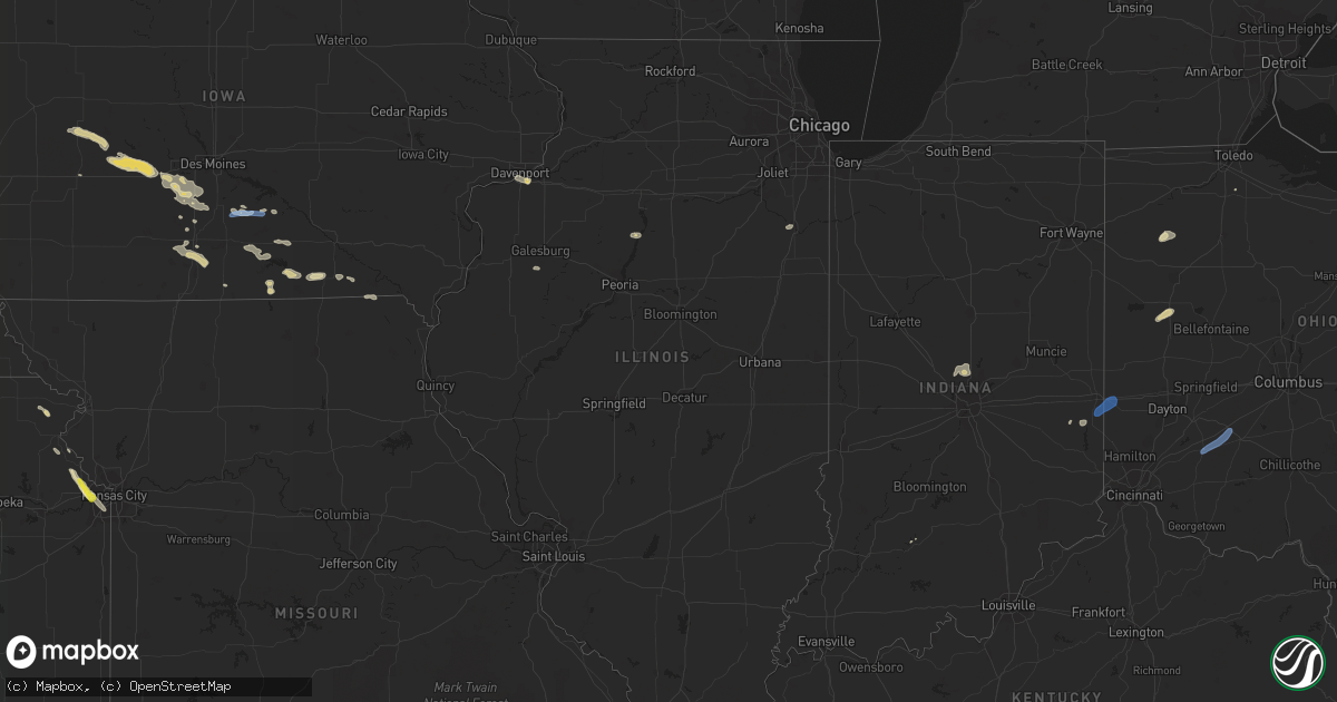
Hail Map in Illinois on June 6, 2022
Get this storm
June 6 map
$229
one time, instant access
Download today. No call, no setup
Keep the $229
Bought the map and want the full workflow? Apply the entire $229 to a subscription within 7 days. None of it is wasted.
Every map, not just this one
This buys you this map. Subscription and you get every map we run, in the markets you choose from a few cities to whole states to nationwide. Plus real-time alerts the moment a storm fires.
Contact data
Name, contact info, occupancy, even credit band for addresses in the footprint. You go from where it hit to who to call.
Become the source they trust
Unlimited branding weather history reports on demand. You already have the documented answer ready for the property owner, and you are the one who showed up with it.
Property data and RoofTrace estimates
Pull up any address you have got, its value and the exact code rules for that jurisdiction, straight from One Click Code. Then RoofTrace estimates the squares, pitch, and roof value, priced the way you price.
Storm reports in Illinois
Illinois
| Date | Description |
|---|---|
| 06/06/20225:54 PM CDT | Kil-compt5. |
| 06/06/20225:20 PM CDT | Social media damage report showing destroyed crops from hail... And significant damage to house siding near intersection of 2400 and highway 92. Time estimated from rad |
| 06/06/20224:50 PM CDT | Just north of the 74/80 interchange. |
| 06/06/20224:41 PM CDT | Occurring right now. |
| 06/06/20224:41 PM CDT | A local report indicates 1.00 inch wind near 2 ESE COAL VALLEY |
| 06/06/20224:40 PM CDT | Corrects time and size of previous hail report from 2 ssw coal valley. Dime to quarter size hail. |
| 06/06/202212:39 AM CDT | At 539 PM CDT, a severe thunderstorm was located near Paw Paw, or 9 miles north of Mendota, moving southeast at 25 mph. HAZARD...60 mph wind gusts and penny size hail. SOURCE...Radar indicated. IMPACT...Expect damage to roofs, siding, and trees. Locations impacted include... Mendota, Earlville, Leland, Paw Paw, Sublette, Compton and West Brooklyn.Including the following interstate... I-39 between mile markers 71 and 84. This includes...Tri-County Fairgrounds. |
| 06/06/202212:12 AM CDT | At 511 PM CDT, a severe thunderstorm was located near Walnut, or 10 miles north of Princeton, moving northeast at 20 mph. A second severe thunderstorm was located 5 miles north of Amboy, moving southeast at 20 mph. HAZARD...60 mph wind gusts and half dollar size hail. SOURCE...Radar indicated. IMPACT...Hail damage to vehicles is expected. Expect wind damage to roofs, siding, and trees. Locations impacted include... Amboy, Sublette, Woodhaven Lakes, West Brooklyn and Lee Center. Including the following interstate... I-88 near mile marker 62. This includes...Lee County Fairgrounds. |
| 06/06/202212:04 AM CDT | At 504 PM CDT, a severe thunderstorm was located over Geneseo, or 8 miles north of Cambridge, moving east at 30 mph. HAZARD...60 mph wind gusts and quarter size hail. SOURCE...Radar indicated. IMPACT...Hail damage to vehicles is expected. Expect wind damage to roofs, siding, and trees. This severe thunderstorm will be near... Atkinson around 520 PM CDT.Other locations in the path of this severe thunderstorm includeAnnawan and Johnson-Sauk Trail State Park. |
| 06/05/202211:53 PM CDT | At 453 PM CDT, a severe thunderstorm was located near Kasbeer, or 8 miles northwest of Princeton, moving northeast at 25 mph. HAZARD...60 mph wind gusts and quarter size hail. SOURCE...Radar indicated. IMPACT...Hail damage to vehicles is expected. Expect wind damage to roofs, siding, and trees. This severe thunderstorm will be near... Kasbeer around 505 PM CDT. Ohio around 510 PM CDT.Other locations in the path of this severe thunderstorm include VanOrin and La Moille. |
| 06/05/202211:23 PM CDT | At 423 PM CDT, a severe thunderstorm was located over Tiskilwa, or 8 miles west of Hennepin, moving northeast at 25 mph. HAZARD...60 mph wind gusts and quarter size hail. SOURCE...Radar indicated. IMPACT...Hail damage to vehicles is expected. Expect wind damage to roofs, siding, and trees. This severe thunderstorm will be near... Bureau Junction around 435 PM CDT. Hennepin and Bureau County Fairgrounds around 440 PM CDT.Other locations in the path of this severe thunderstorm includePrinceton, DePue, Coal Hollow, Malden, Seatonville, Dover,Hollowayville, Ottville, Spring Valley Airport, Spring Valley, Ladd,Zearing, Cherry and Arlington. |
All States Impacted by Hail Map on June 6, 2022
Cities Impacted by Hail Map on June 6, 2022
- Menlo, IA
- Adair, IA
- Casey, IA
- Dexter, IA
- Stuart, IA
- Earlham, IA
- Panora, IA
- Guthrie Center, IA
- Redfield, IA
- Ellsworth, NE
- Rushville, NE
- Peru, IA
- Truro, IA
- Abingdon, IL
- Galesburg, IL
- Camden, TN
- Pemberville, OH
- Hale, MO
- Chillicothe, MO
- Mendon, MO
- Sumner, MO
- Sheridan, MO
- Hopkins, MO
- Merriman, NE
- Cody, NE
- Osceola, IA
- Thedford, NE
- Valentine, NE
- Garden Grove, IA
- Van Wert, IA
- Murray, IA
- Thayer, IA
- Humeston, IA
- Weldon, IA
- Rush, CO
- Peyton, CO
- Arlington, CO
- Sugar City, CO
- Calhan, CO
- Karval, CO
- Ordway, CO
- Yoder, CO
- Cloverdale, OH
- Ottawa, OH
- Continental, OH
- Drakesville, IA
- Moulton, IA
- Bloomfield, IA
- Albion, NE
- Genoa, NE
- Elgin, NE
- Clearwater, NE
- Columbus, NE
- Osceola, NE
- Silver Creek, NE
- Saint Edward, NE
- Petersburg, NE
- Barnesville, GA
- Portageville, MO
- Wardell, MO
- Amity, MO
- Mitchell, IN
- Springville, TN
- Mansfield, TN
- Bucklin, KS
- Cottontown, TN
- Hendersonville, TN
- Hermitage, TN
- Castalian Springs, TN
- Goodlettsville, TN
- Lascassas, TN
- Bethpage, TN
- Old Hickory, TN
- Westmoreland, TN
- White House, TN
- Watertown, TN
- Lebanon, TN
- Olmstead, KY
- Gallatin, TN
- Murfreesboro, TN
- Springfield, TN
- Greenbrier, TN
- Orlinda, TN
- Red Boiling Springs, TN
- Madison, TN
- Adairville, KY
- Lafayette, TN
- Nashville, TN
- Adams, TN
- Cross Plains, TN
- Mount Juliet, TN
- Milton, TN
- Auburntown, TN
- Cedar Hill, TN
- Portland, TN
- Atlantic, IA
- Allerton, IA
- Whitman, NE
- Rock Island, IL
- Coal Valley, IL
- Milan, IL
- Moline, IL
- Green City, MO
- Kansas City, MO
- Albany, MO
- Denver, MO
- Worth, MO
- Gentry, MO
- Grant City, MO
- Troy, KS
- Robinson, KS
- Denton, KS
- Bendena, KS
- Udell, IA
- Mystic, IA
- Centerville, IA
- Penrose, CO
- Blanchard, OK
- Melcher Dallas, IA
- Milo, IA
- Knoxville, IA
- Lacona, IA
- Adolphus, KY
- Franklin, KY
- Ulysses, KS
- Johnson, KS
- Howard, KS
- Carmel, IN
- Zionsville, IN
- Westfield, IN
- Sheridan, IN
- Big Sandy, TN
- Gainesboro, TN
- Granville, TN
- Ripley, TN
- Henning, TN
- Michigan City, MS
- Ashland, MS
- Walnut, MS
- Falkner, MS
- Tiplersville, MS
- Gordon, NE
- Bussey, IA
- Tracy, IA
- Harper, KS
- Las Animas, CO
- Fayette, MO
- Armstrong, MO
- Kinsley, KS
- Ness City, KS
- Burdett, KS
- Hanston, KS
- Plant City, FL
- Liberal, KS
- Milan, MO
- Toone, TN
- Stanton, TN
- Whiteville, TN
- Fort Cobb, OK
- Callaway, NE
- Broken Bow, NE
- Dalhart, TX
- Hartley, TX
- Dumas, TX
- Masterson, TX
- Channing, TX
- Buffalo, WY
- Mullen, NE
- Ford, KS
- Greensburg, KS
- Woodburn, KY
- Ashland City, TN
- Franklin, TN
- College Grove, TN
- Arrington, TN
- Nolensville, TN
- Ewing, NE
- Atchison, KS
- Deltona, FL
- Lake Helen, FL
- Novinger, MO
- Green Castle, MO
- Manning, IA
- Coon Rapids, IA
- Audubon, IA
- Gray, IA
- Unionville, MO
- Newcastle, WY
- Brunswick, GA
- Hinton, OK
- Calumet, OK
- Clinton, OK
- Jasper, FL
- Beloit, KS
- Glasco, KS
- Delphos, KS
- Henry, IL
- Sparland, IL
- Lacon, IL
- Hugo, CO
- Limon, CO
- Boone, CO
- Pueblo, CO
- Fountain, CO
- Colorado Springs, CO
- Lake Panasoffkee, FL
- Green Cove Springs, FL
- Lancaster, MO
- Downing, MO
- Kankakee, IL
- Chambers, NE
- Oneill, NE
- Inman, NE
- Memphis, TN
- Thompsons Station, TN
- Custer, SD
- Edgemont, SD
- Hot Springs, SD
- Huntingdon, TN
- Hazard, NE
- Mason City, NE
- Litchfield, NE
- Ansley, NE
- Pleasanton, NE
- Russellville, KY
- Auburn, KY
- Brownsville, TN
- Bruceton, TN
- Buena Vista, TN
- Waverly, TN
- Eva, TN
- New Johnsonville, TN
- Pocasset, OK
- Lookeba, OK
- Minco, OK
- Verden, OK
- Chickasha, OK
- Gracemont, OK
- Hydro, OK
- Anadarko, OK
- Amber, OK
- Binger, OK
- Cheyenne Wells, CO
- Kit Carson, CO
- Vona, CO
- Flagler, CO
- Saint Charles, IA
- Osteen, FL
- Paris, TN
- Melrose, IA
- Albia, IA
- Botkins, OH
- Wapakoneta, OH
- Anna, OH
- New Bremen, OH
- New Knoxville, OH
- Butler, OK
- Oakley, KS
- Norman, OK
- Ninnekah, OK
- Washington, OK
- Rush Springs, OK
- Alex, OK
- Purcell, OK
- Lindsay, OK
- Bradley, OK
- Arnold, NE
- Franklin, NE
- Stapleton, NE
- Riverton, NE
- Miller, NE
- Hildreth, NE
- Lebanon, KS
- Overton, NE
- Gibbon, NE
- Gothenburg, NE
- Kearney, NE
- Brady, NE
- Upland, NE
- Heartwell, NE
- Burr Oak, KS
- Bladen, NE
- Funk, NE
- Axtell, NE
- Inavale, NE
- Seneca, NE
- Campbell, NE
- Ravenna, NE
- Lexington, NE
- Eddyville, NE
- Tryon, NE
- Red Cloud, NE
- Esbon, KS
- Wilcox, NE
- Riverdale, NE
- Amherst, NE
- Elm Creek, NE
- Odessa, NE
- Minden, NE
- Oconto, NE
- Shelton, NE
- Sumner, NE
- New Virginia, IA
- Bedford, KY
- Cantril, IA
- Memphis, MO
- Arbela, MO
- Coatsville, MO
- Glenwood, MO
- Cincinnati, IA
- Seymour, IA
- Charlotte, TN
- Savannah, MO
- Fillmore, MO
- Batesland, SD
- Pine Ridge, SD
- Manderson, SD
- Wounded Knee, SD
- Blencoe, IA
- Guymon, OK
- Goodwell, OK
- Elkhart, KS
- Moscow, KS
- Rolla, KS
- Walsh, CO
- Hugoton, KS
- Manter, KS
- Campo, CO
- Hooker, OK
- Richfield, KS
- Tyrone, OK
- Holstein, NE
- Blue Hill, NE
- Guide Rock, NE
- Ayr, NE
- Roseland, NE
- Superior, NE
- Lawrence, NE
- Princeton, MO
- Harris, MO
- Newtown, MO
- Hasty, CO
- Jennings, FL
- Mayo, FL
- Live Oak, FL
- De Leon Springs, FL
- Ormond Beach, FL
- Patterson, IA
- Van Meter, IA
- Winterset, IA
- Prole, IA
- Texhoma, OK
- Lake Butler, FL
- Cumming, IA
- De Soto, IA
- Martensdale, IA
- Indianola, IA
- Norwalk, IA
- Bevington, IA
- Lucas, KS
- Hunter, KS
- Sylvan Grove, KS
- Larned, KS
- Maysville, OK
- Wayne, OK
- Lobelville, TN
- Holly, CO
- Lamar, CO
- Granada, CO
- Spearville, KS
- Christmas, FL
- West Memphis, AR
- Marion, AR
- Proctor, AR
- Boca Raton, FL
- Kansas City, KS
- Basehor, KS
- Bonner Springs, KS
- Leavenworth, KS
- Palm Coast, FL
- Palm City, FL
- Stuart, FL
- McRae Helena, GA
- Micanopy, FL
- Gainesville, FL
- Hawthorne, FL
- Deland, FL
- Canute, OK
- Foss, OK
- Chiefland, FL
- Lecanto, FL
- Homosassa, FL
- Bradford, TN
- Rutherford, TN
- Stratford, OK
- Crescent City, FL
- Wynnewood, OK
- Pauls Valley, OK
- Paoli, OK
- Ada, OK
- Byars, OK
- Jetmore, KS
- Matheson, CO
- Cordell, OK
- Carnegie, OK
- Colony, OK
- Corn, OK
- Offerle, KS
- Cordova, TN
- Eads, TN
- Rozel, KS
- Oviedo, FL
- Winter Springs, FL
- Trezevant, TN
- Atwood, TN
- Milan, TN
- Connersville, IN
- Rush Center, KS
- Nekoma, KS
- Geneva, FL
- Mims, FL
- Winter Park, FL
- Sanford, FL
- Casselberry, FL
- Inverness, FL
- Bushnell, FL
- Brooksville, FL
- Floral City, FL
- Williamson, GA
- Concord, GA
- Gilman City, MO
- Plano, IA
- Chariton, IA
- Russell, IA
- Wright, KS
- Hickory Valley, TN
- Somerville, TN
- Grand Junction, TN
- Debary, FL
- Noble, OK
- Lexington, OK
- Altoona, FL
- Eagleville, TN
- Brownsville, IN
- Liberty, IN
- Simla, CO
- Overland Park, KS
- Prairie Village, KS
- Lansing, KS
- Shawnee, KS
- Mission, KS
- Whigham, GA
- Wildersville, TN
- Cedar Grove, TN
- Dyer, TN
- Greenfield, TN
- Yuma, TN
- Trenton, TN
- Holladay, TN
- Westport, TN
- McKenzie, TN
- Kismet, KS
- Elkton, FL
- Hobe Sound, FL
- Orlando, FL
- Stonewall, OK
- Flagler Beach, FL
- Astor, FL
- Collierville, TN
- Fargo, GA
- Mankato, KS
- Webber, KS
- Holdrege, NE
- Bloomington, NE
- Corydon, IA
- Putnam, IL
- Tiskilwa, IL
- Ohio, IL
- Olney Springs, CO
- Winona, KS
- Joelton, TN
- Columbia, IA
- Ensign, KS
- Montezuma, KS
- Ingalls, KS
- Dodge City, KS
- Cimarron, KS
- Booker, TX
- Perryton, TX
- Balko, OK
- Turpin, OK
- Spearman, TX
- Hardesty, OK
- Beaver, OK
- Tupelo, OK
- Osco, IL
- East Moline, IL
- Geneseo, IL
- Colona, IL
- Princeton, IL
- Walnut, IL
- Sublette, IL
- Wyanet, IL
- La Moille, IL
- Monroe, NE
- Dunning, NE
- Anselmo, NE
- Purdum, NE
- Halsey, NE
- Buffalo Gap, SD
- Oelrichs, SD
- Smithwick, SD
- Oral, SD
- Hay Springs, NE
- Martin, SD
- Rapid City, SD
- Hermosa, SD
- Scenic, SD
- Merna, NE
- Ashby, NE
- Washington Court House, OH
- Sabina, OH
- Wilmington, OH
- Richmond, IN
- Boston, IN
- New Paris, OH
- Eaton, OH
- Eldorado, OH
- La Junta, CO
- Rocky Ford, CO
- Arriba, CO
- Genoa, CO
- Elbert, CO


