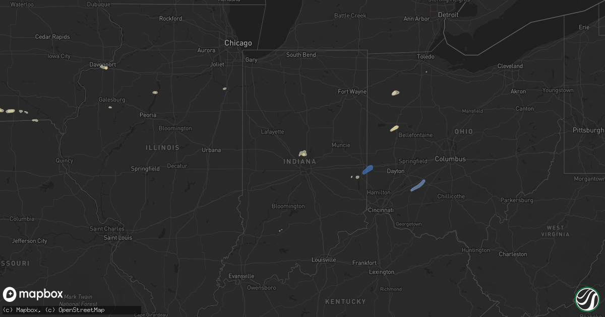
Hail Map in Indiana on June 6, 2022
Get this storm
June 6 map
$229
one time, instant access
Download today. No call, no setup
Keep the $229
Bought the map and want the full workflow? Apply the entire $229 to a subscription within 7 days. None of it is wasted.
Every map, not just this one
This buys you this map. Subscription and you get every map we run, in the markets you choose from a few cities to whole states to nationwide. Plus real-time alerts the moment a storm fires.
Contact data
Name, contact info, occupancy, even credit band for addresses in the footprint. You go from where it hit to who to call.
Become the source they trust
Unlimited branding weather history reports on demand. You already have the documented answer ready for the property owner, and you are the one who showed up with it.
Property data and RoofTrace estimates
Pull up any address you have got, its value and the exact code rules for that jurisdiction, straight from One Click Code. Then RoofTrace estimates the squares, pitch, and roof value, priced the way you price.
Storm reports in Indiana
Indiana
| Date | Description |
|---|---|
| 06/06/20223:25 PM CDT | A local report indicates 60 MPH wind near KRID RICHMOND APT |
| 06/06/20222:55 PM CDT | Tree down on wires on west klein. Time estimated from radar. |
| 06/06/20222:43 PM CDT | Tree down power pole on 229. Time estimated from radar. |
| 06/06/20222:32 PM CDT | Tree downed across a portion of interstate 74. Time estimated by radar. |
| 06/06/20222:27 PM CDT | Large tree downed across sr 229 and huntsville rd. Time estimated by radar. |
| 06/06/20221:58 PM CDT | Tree removed from road near 56 and lamb drive. Time estimated from radar. |
| 06/06/20222:43 AM CDT | At 743 PM EDT, a severe thunderstorm was located near Royal Center, or 7 miles northwest of Logansport, moving northeast at 15 mph. HAZARD...60 mph wind gusts. SOURCE...Radar indicated. IMPACT...Expect damage to roofs, siding, and trees. Locations impacted include... Royal Center, Lucerne and Leases Corner. |
| 06/05/202211:17 PM CDT | At 417 PM EDT, a severe thunderstorm was located over Liberty, moving northeast at 40 mph. HAZARD...60 mph wind gusts. SOURCE...Radar indicated. IMPACT...Expect damage to trees and power lines. Locations impacted include... Richmond, Eaton, Liberty, Camden, Lewisburg, New Paris, West Alexandria, Salem, Abington, Eldorado, West Manchester, Boston, Richmond Municipal Airport, Whitewater State Park, Goodwins Corner, Oklahoma, West Florence, Cottage Grove, Wheatville and Interstate 70 at US Route 127.This includes the following Interstates... I-70 in Indiana between mile markers 153 and 156. I-70 in Ohio between mile markers 0 and 15. |
| 06/05/202210:32 PM CDT | At 332 PM EDT, a severe thunderstorm was located near Batesville, moving northeast at 45 mph. HAZARD...60 mph wind gusts. SOURCE...Radar indicated. IMPACT...Expect damage to trees and power lines. Locations impacted include... Hamilton, Oxford, Batesville, Brookville, Milan, West College Corner, Oldenburg, Darrtown, Reily, Sunman, Metamora, St. Leon, Scipio, College Corner, Cedar Grove, Mount Carmel, Mounds State Recreation Area, Huntersville, Hamburg and Penntown.This includes I-74 in Indiana between mile markers 145 and 167. |
| 06/05/20229:42 PM CDT | At 241 PM EDT, a severe thunderstorm was located near Bedford, moving northeast at 50 mph. HAZARD...60 mph wind gusts. SOURCE...Radar indicated. IMPACT...Expect damage to trees and power lines. Locations impacted include... Carrollton, Williamstown, Rising Sun, Crittenden, Dry Ridge, Vevay, Warsaw, Florence, Kentucky Speedway, French, Glencoe, Fairview, Ghent, Sanders, Sparta, Patriot, Worthville, Prestonville, Aberdeen and Ryle.This includes the following Interstates... I-71 in Kentucky between mile markers 39 and 75. I-75 in Kentucky between mile markers 158 and 166. |
All States Impacted by Hail Map on June 6, 2022
Cities Impacted by Hail Map on June 6, 2022
- Menlo, IA
- Adair, IA
- Casey, IA
- Dexter, IA
- Stuart, IA
- Earlham, IA
- Panora, IA
- Guthrie Center, IA
- Redfield, IA
- Ellsworth, NE
- Rushville, NE
- Peru, IA
- Truro, IA
- Abingdon, IL
- Galesburg, IL
- Camden, TN
- Pemberville, OH
- Hale, MO
- Chillicothe, MO
- Mendon, MO
- Sumner, MO
- Sheridan, MO
- Hopkins, MO
- Merriman, NE
- Cody, NE
- Osceola, IA
- Thedford, NE
- Valentine, NE
- Garden Grove, IA
- Van Wert, IA
- Murray, IA
- Thayer, IA
- Humeston, IA
- Weldon, IA
- Rush, CO
- Peyton, CO
- Arlington, CO
- Sugar City, CO
- Calhan, CO
- Karval, CO
- Ordway, CO
- Yoder, CO
- Cloverdale, OH
- Ottawa, OH
- Continental, OH
- Drakesville, IA
- Moulton, IA
- Bloomfield, IA
- Albion, NE
- Genoa, NE
- Elgin, NE
- Clearwater, NE
- Columbus, NE
- Osceola, NE
- Silver Creek, NE
- Saint Edward, NE
- Petersburg, NE
- Barnesville, GA
- Portageville, MO
- Wardell, MO
- Amity, MO
- Mitchell, IN
- Springville, TN
- Mansfield, TN
- Bucklin, KS
- Cottontown, TN
- Hendersonville, TN
- Hermitage, TN
- Castalian Springs, TN
- Goodlettsville, TN
- Lascassas, TN
- Bethpage, TN
- Old Hickory, TN
- Westmoreland, TN
- White House, TN
- Watertown, TN
- Lebanon, TN
- Olmstead, KY
- Gallatin, TN
- Murfreesboro, TN
- Springfield, TN
- Greenbrier, TN
- Orlinda, TN
- Red Boiling Springs, TN
- Madison, TN
- Adairville, KY
- Lafayette, TN
- Nashville, TN
- Adams, TN
- Cross Plains, TN
- Mount Juliet, TN
- Milton, TN
- Auburntown, TN
- Cedar Hill, TN
- Portland, TN
- Atlantic, IA
- Allerton, IA
- Whitman, NE
- Rock Island, IL
- Coal Valley, IL
- Milan, IL
- Moline, IL
- Green City, MO
- Kansas City, MO
- Albany, MO
- Denver, MO
- Worth, MO
- Gentry, MO
- Grant City, MO
- Troy, KS
- Robinson, KS
- Denton, KS
- Bendena, KS
- Udell, IA
- Mystic, IA
- Centerville, IA
- Penrose, CO
- Blanchard, OK
- Melcher Dallas, IA
- Milo, IA
- Knoxville, IA
- Lacona, IA
- Adolphus, KY
- Franklin, KY
- Ulysses, KS
- Johnson, KS
- Howard, KS
- Carmel, IN
- Zionsville, IN
- Westfield, IN
- Sheridan, IN
- Big Sandy, TN
- Gainesboro, TN
- Granville, TN
- Ripley, TN
- Henning, TN
- Michigan City, MS
- Ashland, MS
- Walnut, MS
- Falkner, MS
- Tiplersville, MS
- Gordon, NE
- Bussey, IA
- Tracy, IA
- Harper, KS
- Las Animas, CO
- Fayette, MO
- Armstrong, MO
- Kinsley, KS
- Ness City, KS
- Burdett, KS
- Hanston, KS
- Plant City, FL
- Liberal, KS
- Milan, MO
- Toone, TN
- Stanton, TN
- Whiteville, TN
- Fort Cobb, OK
- Callaway, NE
- Broken Bow, NE
- Dalhart, TX
- Hartley, TX
- Dumas, TX
- Masterson, TX
- Channing, TX
- Buffalo, WY
- Mullen, NE
- Ford, KS
- Greensburg, KS
- Woodburn, KY
- Ashland City, TN
- Franklin, TN
- College Grove, TN
- Arrington, TN
- Nolensville, TN
- Ewing, NE
- Atchison, KS
- Deltona, FL
- Lake Helen, FL
- Novinger, MO
- Green Castle, MO
- Manning, IA
- Coon Rapids, IA
- Audubon, IA
- Gray, IA
- Unionville, MO
- Newcastle, WY
- Brunswick, GA
- Hinton, OK
- Calumet, OK
- Clinton, OK
- Jasper, FL
- Beloit, KS
- Glasco, KS
- Delphos, KS
- Henry, IL
- Sparland, IL
- Lacon, IL
- Hugo, CO
- Limon, CO
- Boone, CO
- Pueblo, CO
- Fountain, CO
- Colorado Springs, CO
- Lake Panasoffkee, FL
- Green Cove Springs, FL
- Lancaster, MO
- Downing, MO
- Kankakee, IL
- Chambers, NE
- Oneill, NE
- Inman, NE
- Memphis, TN
- Thompsons Station, TN
- Custer, SD
- Edgemont, SD
- Hot Springs, SD
- Huntingdon, TN
- Hazard, NE
- Mason City, NE
- Litchfield, NE
- Ansley, NE
- Pleasanton, NE
- Russellville, KY
- Auburn, KY
- Brownsville, TN
- Bruceton, TN
- Buena Vista, TN
- Waverly, TN
- Eva, TN
- New Johnsonville, TN
- Pocasset, OK
- Lookeba, OK
- Minco, OK
- Verden, OK
- Chickasha, OK
- Gracemont, OK
- Hydro, OK
- Anadarko, OK
- Amber, OK
- Binger, OK
- Cheyenne Wells, CO
- Kit Carson, CO
- Vona, CO
- Flagler, CO
- Saint Charles, IA
- Osteen, FL
- Paris, TN
- Melrose, IA
- Albia, IA
- Botkins, OH
- Wapakoneta, OH
- Anna, OH
- New Bremen, OH
- New Knoxville, OH
- Butler, OK
- Oakley, KS
- Norman, OK
- Ninnekah, OK
- Washington, OK
- Rush Springs, OK
- Alex, OK
- Purcell, OK
- Lindsay, OK
- Bradley, OK
- Arnold, NE
- Franklin, NE
- Stapleton, NE
- Riverton, NE
- Miller, NE
- Hildreth, NE
- Lebanon, KS
- Overton, NE
- Gibbon, NE
- Gothenburg, NE
- Kearney, NE
- Brady, NE
- Upland, NE
- Heartwell, NE
- Burr Oak, KS
- Bladen, NE
- Funk, NE
- Axtell, NE
- Inavale, NE
- Seneca, NE
- Campbell, NE
- Ravenna, NE
- Lexington, NE
- Eddyville, NE
- Tryon, NE
- Red Cloud, NE
- Esbon, KS
- Wilcox, NE
- Riverdale, NE
- Amherst, NE
- Elm Creek, NE
- Odessa, NE
- Minden, NE
- Oconto, NE
- Shelton, NE
- Sumner, NE
- New Virginia, IA
- Bedford, KY
- Cantril, IA
- Memphis, MO
- Arbela, MO
- Coatsville, MO
- Glenwood, MO
- Cincinnati, IA
- Seymour, IA
- Charlotte, TN
- Savannah, MO
- Fillmore, MO
- Batesland, SD
- Pine Ridge, SD
- Manderson, SD
- Wounded Knee, SD
- Blencoe, IA
- Guymon, OK
- Goodwell, OK
- Elkhart, KS
- Moscow, KS
- Rolla, KS
- Walsh, CO
- Hugoton, KS
- Manter, KS
- Campo, CO
- Hooker, OK
- Richfield, KS
- Tyrone, OK
- Holstein, NE
- Blue Hill, NE
- Guide Rock, NE
- Ayr, NE
- Roseland, NE
- Superior, NE
- Lawrence, NE
- Princeton, MO
- Harris, MO
- Newtown, MO
- Hasty, CO
- Jennings, FL
- Mayo, FL
- Live Oak, FL
- De Leon Springs, FL
- Ormond Beach, FL
- Patterson, IA
- Van Meter, IA
- Winterset, IA
- Prole, IA
- Texhoma, OK
- Lake Butler, FL
- Cumming, IA
- De Soto, IA
- Martensdale, IA
- Indianola, IA
- Norwalk, IA
- Bevington, IA
- Lucas, KS
- Hunter, KS
- Sylvan Grove, KS
- Larned, KS
- Maysville, OK
- Wayne, OK
- Lobelville, TN
- Holly, CO
- Lamar, CO
- Granada, CO
- Spearville, KS
- Christmas, FL
- West Memphis, AR
- Marion, AR
- Proctor, AR
- Boca Raton, FL
- Kansas City, KS
- Basehor, KS
- Bonner Springs, KS
- Leavenworth, KS
- Palm Coast, FL
- Palm City, FL
- Stuart, FL
- McRae Helena, GA
- Micanopy, FL
- Gainesville, FL
- Hawthorne, FL
- Deland, FL
- Canute, OK
- Foss, OK
- Chiefland, FL
- Lecanto, FL
- Homosassa, FL
- Bradford, TN
- Rutherford, TN
- Stratford, OK
- Crescent City, FL
- Wynnewood, OK
- Pauls Valley, OK
- Paoli, OK
- Ada, OK
- Byars, OK
- Jetmore, KS
- Matheson, CO
- Cordell, OK
- Carnegie, OK
- Colony, OK
- Corn, OK
- Offerle, KS
- Cordova, TN
- Eads, TN
- Rozel, KS
- Oviedo, FL
- Winter Springs, FL
- Trezevant, TN
- Atwood, TN
- Milan, TN
- Connersville, IN
- Rush Center, KS
- Nekoma, KS
- Geneva, FL
- Mims, FL
- Winter Park, FL
- Sanford, FL
- Casselberry, FL
- Inverness, FL
- Bushnell, FL
- Brooksville, FL
- Floral City, FL
- Williamson, GA
- Concord, GA
- Gilman City, MO
- Plano, IA
- Chariton, IA
- Russell, IA
- Wright, KS
- Hickory Valley, TN
- Somerville, TN
- Grand Junction, TN
- Debary, FL
- Noble, OK
- Lexington, OK
- Altoona, FL
- Eagleville, TN
- Brownsville, IN
- Liberty, IN
- Simla, CO
- Overland Park, KS
- Prairie Village, KS
- Lansing, KS
- Shawnee, KS
- Mission, KS
- Whigham, GA
- Wildersville, TN
- Cedar Grove, TN
- Dyer, TN
- Greenfield, TN
- Yuma, TN
- Trenton, TN
- Holladay, TN
- Westport, TN
- McKenzie, TN
- Kismet, KS
- Elkton, FL
- Hobe Sound, FL
- Orlando, FL
- Stonewall, OK
- Flagler Beach, FL
- Astor, FL
- Collierville, TN
- Fargo, GA
- Mankato, KS
- Webber, KS
- Holdrege, NE
- Bloomington, NE
- Corydon, IA
- Putnam, IL
- Tiskilwa, IL
- Ohio, IL
- Olney Springs, CO
- Winona, KS
- Joelton, TN
- Columbia, IA
- Ensign, KS
- Montezuma, KS
- Ingalls, KS
- Dodge City, KS
- Cimarron, KS
- Booker, TX
- Perryton, TX
- Balko, OK
- Turpin, OK
- Spearman, TX
- Hardesty, OK
- Beaver, OK
- Tupelo, OK
- Osco, IL
- East Moline, IL
- Geneseo, IL
- Colona, IL
- Princeton, IL
- Walnut, IL
- Sublette, IL
- Wyanet, IL
- La Moille, IL
- Monroe, NE
- Dunning, NE
- Anselmo, NE
- Purdum, NE
- Halsey, NE
- Buffalo Gap, SD
- Oelrichs, SD
- Smithwick, SD
- Oral, SD
- Hay Springs, NE
- Martin, SD
- Rapid City, SD
- Hermosa, SD
- Scenic, SD
- Merna, NE
- Ashby, NE
- Washington Court House, OH
- Sabina, OH
- Wilmington, OH
- Richmond, IN
- Boston, IN
- New Paris, OH
- Eaton, OH
- Eldorado, OH
- La Junta, CO
- Rocky Ford, CO
- Arriba, CO
- Genoa, CO
- Elbert, CO


