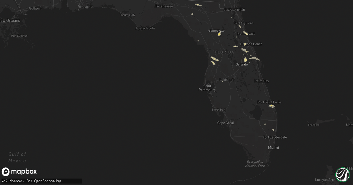
Hail Map in Florida on June 6, 2022
Get this storm
June 6 map
$229
one time, instant access
Download today. No call, no setup
Keep the $229
Bought the map and want the full workflow? Apply the entire $229 to a subscription within 7 days. None of it is wasted.
Every map, not just this one
This buys you this map. Subscription and you get every map we run, in the markets you choose from a few cities to whole states to nationwide. Plus real-time alerts the moment a storm fires.
Contact data
Name, contact info, occupancy, even credit band for addresses in the footprint. You go from where it hit to who to call.
Become the source they trust
Unlimited branding weather history reports on demand. You already have the documented answer ready for the property owner, and you are the one who showed up with it.
Property data and RoofTrace estimates
Pull up any address you have got, its value and the exact code rules for that jurisdiction, straight from One Click Code. Then RoofTrace estimates the squares, pitch, and roof value, priced the way you price.
Storm reports in Florida
Florida
| Date | Description |
|---|---|
| 06/06/20225:19 PM CDT | Based on pictures and videos received from trained spotters... Local broadcast media... And the public... Nws melbourne can confirm that an ef-0 tornado touched down in |
| 06/06/20225:05 PM CDT | Trained spotter and local broadcast media relayed reports of a tornado on the ground for several minutes in a field about 2 miles west of i-95 in fort pierce. |
| 06/06/20223:05 PM CDT | Ham radio relayed report from seminole county em of downed powerlines on cr-419 in chuluota. Time estimated from radar. |
| 06/06/20222:55 PM CDT | Public report via twitter of half dollar size hail with picture near red bug lake rd and tuskawilla rd in winter springs. |
| 06/06/20222:50 PM CDT | Second public report via twitter with picture of half dollar size hail near red bug lake rd and tuskawilla rd in winter springs |
| 06/06/20222:49 PM CDT | Trained sportter report via twitter of dime to quarter size hail near kelly green st and n pine ave in ovideo. Time estimated via radar. |
| 06/06/20222:35 PM CDT | Delayed report. Medium size tree branch down and blown into neighbors yard... Photo on twitter. Time estimated from radar. |
| 06/06/20222:20 PM CDT | Spotter reports quarter to half dollar sized hail in palm coast... Location approximated. |
| 06/06/20222:10 PM CDT | One hour delayed report. Em reports of multiple screens blown out of lanias in nw palm coast. |
| 06/06/20222:04 PM CDT | A local report indicates 1.00 inch wind near PALM COAST |
| 06/06/20222:03 PM CDT | Palm coast tree down into transformer wires reported by fcso. |
| 06/06/20222:00 PM CDT | Caller reported a tree down in madison county along highway 53... A mile south of midway church rd. Caller recorded a peak surface wind of 29 mph. |
| 06/06/20221:30 PM CDT | Public report via twitter of dime to quarter size hail near lake helen osteen rd and haulover blvd in deltona. |
| 06/06/20223:10 AM CDT | At 809 PM EDT, a severe thunderstorm was located over Stuart, moving northeast at 25 mph. HAZARD...60 mph wind gusts and quarter size hail. SOURCE...Radar indicated. IMPACT...Hail damage to vehicles is expected. Expect wind damage to roofs, siding, and trees. Locations impacted include... Stuart, Palm City, Port Salerno, Jensen Beach and Sewall's Point. |
| 06/06/20222:15 AM CDT | At 714 PM EDT, a severe thunderstorm was located over Indian River Estates, or near Saint Lucie Nuclear Power Plant, moving southeast at 15 mph. HAZARD...60 mph wind gusts. SOURCE...Radar indicated. IMPACT...Expect damage to roofs, siding, and trees. Locations impacted include... Port Saint Lucie, Walton, Fort Pierce, White City and Saint Lucie Nuclear Power Plant. |
| 06/06/20221:44 AM CDT | At 644 PM EDT, a severe thunderstorm was located over Fort Pierce North, or over Fort Pierce, moving southeast at 20 mph. HAZARD...60 mph wind gusts. SOURCE...Radar indicated. IMPACT...Expect damage to roofs, siding, and trees. Locations impacted include... Walton, Fort Pierce, White City, Indrio and Saint Lucie Nuclear Power Plant. |
| 06/06/20221:04 AM CDT | At 603 PM EDT, a severe thunderstorm was located 7 miles west of Lakewood Park, or 8 miles southwest of Vero Beach South, moving southeast at 10 mph. HAZARD...60 mph wind gusts and quarter size hail. SOURCE...Radar indicated. IMPACT...Hail damage to vehicles is expected. Expect wind damage to roofs, siding, and trees. Locations impacted include... Fort Pierce, Indrio, Fort Pierce Inlet, White City and Queens Cove. |
| 06/06/202212:16 AM CDT | At 515 PM EDT, a severe thunderstorm was located from over Kennedy Space Center to Port Saint John, moving east at 15 mph. HAZARD...60 mph wind gusts. SOURCE...Radar indicated. IMPACT...Expect damage to roofs, siding, and trees. Locations impacted include... Titusville, Cocoa, Cocoa Beach, Cape Canaveral and Port Saint John. |
| 06/06/202212:04 AM CDT | At 503 PM EDT, a severe thunderstorm was located over Hamptons At Boca Raton, or near Boca Raton, moving east at 10 mph. HAZARD...60 mph wind gusts and quarter size hail. SOURCE...Radar indicated. IMPACT...Hail damage to vehicles is expected. Expect wind damage to roofs, siding, and trees. Locations impacted include... Coral Springs, Pompano Beach, Boca Raton, Deerfield Beach and Delray Beach. |
| 06/05/202211:42 PM CDT | At 441 PM EDT, a severe thunderstorm was located near Cross Creek, or 8 miles northwest of Citra, moving southwest at 10 mph. HAZARD...60 mph wind gusts and nickel size hail. SOURCE...Radar indicated. IMPACT...Expect damage to roofs, siding, and trees. Locations impacted include... Hawthorne, Cross Creek, Rochelle, Micanopy, Reddick, McIntosh, Flemington, Lowell, Lochloosa and Grove Park. |
| 06/05/202211:27 PM CDT | At 427 PM EDT, a severe thunderstorm was located near Mims, moving east at 5 mph. At 424 PM, a 59 mph wind gust was observed in Titusville along the Indian River. HAZARD...60 mph wind gusts and nickel size hail. SOURCE...Radar indicated. IMPACT...Expect damage to roofs, siding, and trees. Locations impacted include... Titusville, Haulover Canal, Mims, Playalinda Beach and Kennedy Space Center. |
| 06/05/202210:41 PM CDT | At 340 PM EDT, a severe thunderstorm was located over Scottsmoor, moving east at 10 mph. HAZARD...60 mph wind gusts and quarter size hail. SOURCE...Radar indicated. IMPACT...Hail damage to vehicles is expected. Expect wind damage to roofs, siding, and trees. Locations impacted include... Oak Hill, Haulover Canal, Mims, Scottsmoor and Maytown. |
| 06/05/202210:40 PM CDT | At 340 PM EDT, a severe thunderstorm was located over Lake Jessup, moving southeast at 15 mph. HAZARD...60 mph wind gusts and quarter size hail. SOURCE...Radar indicated. IMPACT...Hail damage to vehicles is expected. Expect wind damage to roofs, siding, and trees. Locations impacted include... Sanford, Oviedo, Winter Springs, Casselberry and Longwood. |
| 06/05/202210:09 PM CDT | At 309 PM EDT, a severe thunderstorm was located over Palm Coast, moving southeast at 15 mph. HAZARD...60 mph wind gusts and quarter size hail. SOURCE...Radar indicated. IMPACT...Hail damage to vehicles is expected. Expect wind damage to roofs, siding, and trees. Locations impacted include... Palm Coast, Flagler Beach and Beverly Beach. |
| 06/05/20229:03 PM CDT | At 202 PM EDT, a severe thunderstorm was located 7 miles northeast of DeLeon Springs, and is nearly stationary. HAZARD...60 mph wind gusts and quarter size hail. SOURCE...Radar indicated. IMPACT...Hail damage to vehicles is expected. Expect wind damage to roofs, siding, and trees. Locations impacted include... Daytona Beach, DeLand and DeLeon Springs. |
| 06/05/20229:01 PM CDT | At 200 PM EDT, a severe thunderstorm was located 7 miles east of Juniper Springs, and is nearly stationary. HAZARD...60 mph wind gusts and quarter size hail. SOURCE...Radar indicated. IMPACT...Hail damage to vehicles is expected. Expect wind damage to roofs, siding, and trees. Locations impacted include... Pierson, Alexander Springs, Sellers Lake, Astor and Astor Park. |
| 06/05/20227:20 PM CDT | Weatheflow tempest mesonet in stuart on e 7th street measured a peak wind gust of 54kt/62mph. |
All States Impacted by Hail Map on June 6, 2022
Cities Impacted by Hail Map on June 6, 2022
- Menlo, IA
- Adair, IA
- Casey, IA
- Dexter, IA
- Stuart, IA
- Earlham, IA
- Panora, IA
- Guthrie Center, IA
- Redfield, IA
- Ellsworth, NE
- Rushville, NE
- Peru, IA
- Truro, IA
- Abingdon, IL
- Galesburg, IL
- Camden, TN
- Pemberville, OH
- Hale, MO
- Chillicothe, MO
- Mendon, MO
- Sumner, MO
- Sheridan, MO
- Hopkins, MO
- Merriman, NE
- Cody, NE
- Osceola, IA
- Thedford, NE
- Valentine, NE
- Garden Grove, IA
- Van Wert, IA
- Murray, IA
- Thayer, IA
- Humeston, IA
- Weldon, IA
- Rush, CO
- Peyton, CO
- Arlington, CO
- Sugar City, CO
- Calhan, CO
- Karval, CO
- Ordway, CO
- Yoder, CO
- Cloverdale, OH
- Ottawa, OH
- Continental, OH
- Drakesville, IA
- Moulton, IA
- Bloomfield, IA
- Albion, NE
- Genoa, NE
- Elgin, NE
- Clearwater, NE
- Columbus, NE
- Osceola, NE
- Silver Creek, NE
- Saint Edward, NE
- Petersburg, NE
- Barnesville, GA
- Portageville, MO
- Wardell, MO
- Amity, MO
- Mitchell, IN
- Springville, TN
- Mansfield, TN
- Bucklin, KS
- Cottontown, TN
- Hendersonville, TN
- Hermitage, TN
- Castalian Springs, TN
- Goodlettsville, TN
- Lascassas, TN
- Bethpage, TN
- Old Hickory, TN
- Westmoreland, TN
- White House, TN
- Watertown, TN
- Lebanon, TN
- Olmstead, KY
- Gallatin, TN
- Murfreesboro, TN
- Springfield, TN
- Greenbrier, TN
- Orlinda, TN
- Red Boiling Springs, TN
- Madison, TN
- Adairville, KY
- Lafayette, TN
- Nashville, TN
- Adams, TN
- Cross Plains, TN
- Mount Juliet, TN
- Milton, TN
- Auburntown, TN
- Cedar Hill, TN
- Portland, TN
- Atlantic, IA
- Allerton, IA
- Whitman, NE
- Rock Island, IL
- Coal Valley, IL
- Milan, IL
- Moline, IL
- Green City, MO
- Kansas City, MO
- Albany, MO
- Denver, MO
- Worth, MO
- Gentry, MO
- Grant City, MO
- Troy, KS
- Robinson, KS
- Denton, KS
- Bendena, KS
- Udell, IA
- Mystic, IA
- Centerville, IA
- Penrose, CO
- Blanchard, OK
- Melcher Dallas, IA
- Milo, IA
- Knoxville, IA
- Lacona, IA
- Adolphus, KY
- Franklin, KY
- Ulysses, KS
- Johnson, KS
- Howard, KS
- Carmel, IN
- Zionsville, IN
- Westfield, IN
- Sheridan, IN
- Big Sandy, TN
- Gainesboro, TN
- Granville, TN
- Ripley, TN
- Henning, TN
- Michigan City, MS
- Ashland, MS
- Walnut, MS
- Falkner, MS
- Tiplersville, MS
- Gordon, NE
- Bussey, IA
- Tracy, IA
- Harper, KS
- Las Animas, CO
- Fayette, MO
- Armstrong, MO
- Kinsley, KS
- Ness City, KS
- Burdett, KS
- Hanston, KS
- Plant City, FL
- Liberal, KS
- Milan, MO
- Toone, TN
- Stanton, TN
- Whiteville, TN
- Fort Cobb, OK
- Callaway, NE
- Broken Bow, NE
- Dalhart, TX
- Hartley, TX
- Dumas, TX
- Masterson, TX
- Channing, TX
- Buffalo, WY
- Mullen, NE
- Ford, KS
- Greensburg, KS
- Woodburn, KY
- Ashland City, TN
- Franklin, TN
- College Grove, TN
- Arrington, TN
- Nolensville, TN
- Ewing, NE
- Atchison, KS
- Deltona, FL
- Lake Helen, FL
- Novinger, MO
- Green Castle, MO
- Manning, IA
- Coon Rapids, IA
- Audubon, IA
- Gray, IA
- Unionville, MO
- Newcastle, WY
- Brunswick, GA
- Hinton, OK
- Calumet, OK
- Clinton, OK
- Jasper, FL
- Beloit, KS
- Glasco, KS
- Delphos, KS
- Henry, IL
- Sparland, IL
- Lacon, IL
- Hugo, CO
- Limon, CO
- Boone, CO
- Pueblo, CO
- Fountain, CO
- Colorado Springs, CO
- Lake Panasoffkee, FL
- Green Cove Springs, FL
- Lancaster, MO
- Downing, MO
- Kankakee, IL
- Chambers, NE
- Oneill, NE
- Inman, NE
- Memphis, TN
- Thompsons Station, TN
- Custer, SD
- Edgemont, SD
- Hot Springs, SD
- Huntingdon, TN
- Hazard, NE
- Mason City, NE
- Litchfield, NE
- Ansley, NE
- Pleasanton, NE
- Russellville, KY
- Auburn, KY
- Brownsville, TN
- Bruceton, TN
- Buena Vista, TN
- Waverly, TN
- Eva, TN
- New Johnsonville, TN
- Pocasset, OK
- Lookeba, OK
- Minco, OK
- Verden, OK
- Chickasha, OK
- Gracemont, OK
- Hydro, OK
- Anadarko, OK
- Amber, OK
- Binger, OK
- Cheyenne Wells, CO
- Kit Carson, CO
- Vona, CO
- Flagler, CO
- Saint Charles, IA
- Osteen, FL
- Paris, TN
- Melrose, IA
- Albia, IA
- Botkins, OH
- Wapakoneta, OH
- Anna, OH
- New Bremen, OH
- New Knoxville, OH
- Butler, OK
- Oakley, KS
- Norman, OK
- Ninnekah, OK
- Washington, OK
- Rush Springs, OK
- Alex, OK
- Purcell, OK
- Lindsay, OK
- Bradley, OK
- Arnold, NE
- Franklin, NE
- Stapleton, NE
- Riverton, NE
- Miller, NE
- Hildreth, NE
- Lebanon, KS
- Overton, NE
- Gibbon, NE
- Gothenburg, NE
- Kearney, NE
- Brady, NE
- Upland, NE
- Heartwell, NE
- Burr Oak, KS
- Bladen, NE
- Funk, NE
- Axtell, NE
- Inavale, NE
- Seneca, NE
- Campbell, NE
- Ravenna, NE
- Lexington, NE
- Eddyville, NE
- Tryon, NE
- Red Cloud, NE
- Esbon, KS
- Wilcox, NE
- Riverdale, NE
- Amherst, NE
- Elm Creek, NE
- Odessa, NE
- Minden, NE
- Oconto, NE
- Shelton, NE
- Sumner, NE
- New Virginia, IA
- Bedford, KY
- Cantril, IA
- Memphis, MO
- Arbela, MO
- Coatsville, MO
- Glenwood, MO
- Cincinnati, IA
- Seymour, IA
- Charlotte, TN
- Savannah, MO
- Fillmore, MO
- Batesland, SD
- Pine Ridge, SD
- Manderson, SD
- Wounded Knee, SD
- Blencoe, IA
- Guymon, OK
- Goodwell, OK
- Elkhart, KS
- Moscow, KS
- Rolla, KS
- Walsh, CO
- Hugoton, KS
- Manter, KS
- Campo, CO
- Hooker, OK
- Richfield, KS
- Tyrone, OK
- Holstein, NE
- Blue Hill, NE
- Guide Rock, NE
- Ayr, NE
- Roseland, NE
- Superior, NE
- Lawrence, NE
- Princeton, MO
- Harris, MO
- Newtown, MO
- Hasty, CO
- Jennings, FL
- Mayo, FL
- Live Oak, FL
- De Leon Springs, FL
- Ormond Beach, FL
- Patterson, IA
- Van Meter, IA
- Winterset, IA
- Prole, IA
- Texhoma, OK
- Lake Butler, FL
- Cumming, IA
- De Soto, IA
- Martensdale, IA
- Indianola, IA
- Norwalk, IA
- Bevington, IA
- Lucas, KS
- Hunter, KS
- Sylvan Grove, KS
- Larned, KS
- Maysville, OK
- Wayne, OK
- Lobelville, TN
- Holly, CO
- Lamar, CO
- Granada, CO
- Spearville, KS
- Christmas, FL
- West Memphis, AR
- Marion, AR
- Proctor, AR
- Boca Raton, FL
- Kansas City, KS
- Basehor, KS
- Bonner Springs, KS
- Leavenworth, KS
- Palm Coast, FL
- Palm City, FL
- Stuart, FL
- McRae Helena, GA
- Micanopy, FL
- Gainesville, FL
- Hawthorne, FL
- Deland, FL
- Canute, OK
- Foss, OK
- Chiefland, FL
- Lecanto, FL
- Homosassa, FL
- Bradford, TN
- Rutherford, TN
- Stratford, OK
- Crescent City, FL
- Wynnewood, OK
- Pauls Valley, OK
- Paoli, OK
- Ada, OK
- Byars, OK
- Jetmore, KS
- Matheson, CO
- Cordell, OK
- Carnegie, OK
- Colony, OK
- Corn, OK
- Offerle, KS
- Cordova, TN
- Eads, TN
- Rozel, KS
- Oviedo, FL
- Winter Springs, FL
- Trezevant, TN
- Atwood, TN
- Milan, TN
- Connersville, IN
- Rush Center, KS
- Nekoma, KS
- Geneva, FL
- Mims, FL
- Winter Park, FL
- Sanford, FL
- Casselberry, FL
- Inverness, FL
- Bushnell, FL
- Brooksville, FL
- Floral City, FL
- Williamson, GA
- Concord, GA
- Gilman City, MO
- Plano, IA
- Chariton, IA
- Russell, IA
- Wright, KS
- Hickory Valley, TN
- Somerville, TN
- Grand Junction, TN
- Debary, FL
- Noble, OK
- Lexington, OK
- Altoona, FL
- Eagleville, TN
- Brownsville, IN
- Liberty, IN
- Simla, CO
- Overland Park, KS
- Prairie Village, KS
- Lansing, KS
- Shawnee, KS
- Mission, KS
- Whigham, GA
- Wildersville, TN
- Cedar Grove, TN
- Dyer, TN
- Greenfield, TN
- Yuma, TN
- Trenton, TN
- Holladay, TN
- Westport, TN
- McKenzie, TN
- Kismet, KS
- Elkton, FL
- Hobe Sound, FL
- Orlando, FL
- Stonewall, OK
- Flagler Beach, FL
- Astor, FL
- Collierville, TN
- Fargo, GA
- Mankato, KS
- Webber, KS
- Holdrege, NE
- Bloomington, NE
- Corydon, IA
- Putnam, IL
- Tiskilwa, IL
- Ohio, IL
- Olney Springs, CO
- Winona, KS
- Joelton, TN
- Columbia, IA
- Ensign, KS
- Montezuma, KS
- Ingalls, KS
- Dodge City, KS
- Cimarron, KS
- Booker, TX
- Perryton, TX
- Balko, OK
- Turpin, OK
- Spearman, TX
- Hardesty, OK
- Beaver, OK
- Tupelo, OK
- Osco, IL
- East Moline, IL
- Geneseo, IL
- Colona, IL
- Princeton, IL
- Walnut, IL
- Sublette, IL
- Wyanet, IL
- La Moille, IL
- Monroe, NE
- Dunning, NE
- Anselmo, NE
- Purdum, NE
- Halsey, NE
- Buffalo Gap, SD
- Oelrichs, SD
- Smithwick, SD
- Oral, SD
- Hay Springs, NE
- Martin, SD
- Rapid City, SD
- Hermosa, SD
- Scenic, SD
- Merna, NE
- Ashby, NE
- Washington Court House, OH
- Sabina, OH
- Wilmington, OH
- Richmond, IN
- Boston, IN
- New Paris, OH
- Eaton, OH
- Eldorado, OH
- La Junta, CO
- Rocky Ford, CO
- Arriba, CO
- Genoa, CO
- Elbert, CO


