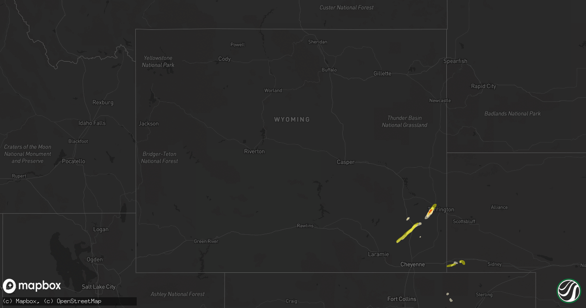
Hail Map in Wyoming on June 6, 2021
Get this storm
June 6 map
$229
one time, instant access
Download today. No call, no setup
Keep the $229
Bought the map and want the full workflow? Apply the entire $229 to a subscription within 7 days. None of it is wasted.
Every map, not just this one
This buys you this map. Subscription and you get every map we run, in the markets you choose from a few cities to whole states to nationwide. Plus real-time alerts the moment a storm fires.
Contact data
Name, contact info, occupancy, even credit band for addresses in the footprint. You go from where it hit to who to call.
Become the source they trust
Unlimited branding weather history reports on demand. You already have the documented answer ready for the property owner, and you are the one who showed up with it.
Property data and RoofTrace estimates
Pull up any address you have got, its value and the exact code rules for that jurisdiction, straight from One Click Code. Then RoofTrace estimates the squares, pitch, and roof value, priced the way you price.
Storm reports in Wyoming
Wyoming
| Date | Description |
|---|---|
| 06/06/20211:37 AM CDT | At 637 PM MDT, a severe thunderstorm was located over Chugwater, or 21 miles southeast of Wheatland, moving northeast at 25 mph. HAZARD...60 mph wind gusts and half dollar size hail. SOURCE...Radar indicated. IMPACT...Hail damage to vehicles is expected. Expect wind damage to roofs, siding, and trees. Locations impacted include... Chugwater and Slater. This includes Interstate 25 in Wyoming between mile markers 56 and61. |
| 06/06/20211:11 AM CDT | At 610 PM MDT, a severe thunderstorm was located 11 miles southwest of Chugwater, or 29 miles south of Wheatland, moving northeast at 25 mph. HAZARD...60 mph wind gusts and quarter size hail. SOURCE...Radar indicated. IMPACT...Hail damage to vehicles is expected. Expect wind damage to roofs, siding, and trees. Locations impacted include... Chugwater.This includes Interstate 25 in Wyoming between mile markers 39 and57, and near mile marker 61. |
| 06/06/202112:32 AM CDT | At 531 PM MDT, a severe thunderstorm was located near Iron Mountain, or 28 miles northeast of Laramie, moving northeast at 20 mph. HAZARD...60 mph wind gusts and quarter size hail. SOURCE...Radar indicated. IMPACT...Hail damage to vehicles is expected. Expect wind damage to roofs, siding, and trees. This severe thunderstorm will remain over mainly rural areas of northwestern Laramie and south central Platte Counties.This includes Interstate 25 in Wyoming between mile markers 34 and43. |
| 06/06/202112:21 AM CDT | At 521 PM MDT, a severe thunderstorm was located near Panorama Point, or 22 miles southwest of Kimball, moving east at 15 mph. HAZARD...60 mph wind gusts and half dollar size hail. SOURCE...Radar indicated. IMPACT...Hail damage to vehicles is expected. Expect wind damage to roofs, siding, and trees. Locations impacted include... Pine Bluffs and Panorama Point. This includes the following highways... Interstate 80 in Wyoming between mile markers 397 and 400, and nearmile marker 402. Interstate 80 in Nebraska between mile markers 1 and 8. |
| 06/05/20219:03 PM CDT | A local report indicates 1.00 inch wind near 1 S LINGLE |
| 06/05/20218:58 PM CDT | Pea to quarter size hail. |
| 06/05/20218:38 PM CDT | A local report indicates 1.75 inch wind near 1 NW VETERAN |
| 06/05/20217:40 PM CDT | Delayed report... Nickel to quarter sized hail. |
| 06/05/20217:35 PM CDT | Report relayed from fire chief of heavy hail damage to north bound vehicles around interstate 25 mile marker 57 north of chugwater. |
All States Impacted by Hail Map on June 6, 2021
Cities Impacted by Hail Map on June 6, 2021
- Kingston, OK
- Madill, OK
- Quitaque, TX
- Turkey, TX
- Clarendon, TX
- Breckenridge, TX
- Graham, TX
- Woodson, TX
- Olton, TX
- Plainview, TX
- Hale Center, TX
- Hart, TX
- Fluvanna, TX
- Tahoka, TX
- Odonnell, TX
- Gail, TX
- Brownfield, TX
- Wichita Falls, TX
- Veteran, WY
- Yoder, WY
- Lingle, WY
- Tipton, OK
- Elmer, OK
- Lamar, CO
- Sand Springs, OK
- Arriba, CO
- Genoa, CO
- Bishop, GA
- Watkinsville, GA
- Bogart, GA
- Athens, GA
- Good Hope, GA
- Throckmorton, TX
- Kress, TX
- Tulia, TX
- Paducah, TX
- Chugwater, WY
- Elgin, OK
- Fletcher, OK
- Apache, OK
- Happy, TX
- Hereford, TX
- Dimmitt, TX
- Collins, GA
- Tribune, KS
- Holly, CO
- Syracuse, KS
- Childress, TX
- Cee Vee, TX
- Lone Wolf, OK
- Roosevelt, OK
- Mountain Park, OK
- Blair, OK
- Snyder, OK
- Frederick, OK
- Hollister, OK
- Silverton, TX
- Floydada, TX
- Petersburg, TX
- Keenesburg, CO
- Anadarko, OK
- Lagrange, ME
- Lamesa, TX
- Bushnell, NE
- Lawton, OK
- Medicine Park, OK
- Hugo, CO
- Matheson, CO
- Afton, TX
- Dickens, TX
- Mcadoo, TX
- Albany, TX
- Briggsdale, CO
- Cheyenne, WY
- Wheatland, WY
- Rush Springs, OK
- Ninnekah, OK
- Welch, TX
- Spur, TX
- Windthorst, TX
- Scotland, TX
- Henrietta, TX
- Limon, CO
- La Salle, CO
- Roggen, CO
- Kersey, CO
- Milo, ME
- Old Town, ME
- Mannford, OK
- Terlton, OK
- Cleveland, OK
- Aspermont, TX
- Electra, TX
- Seymour, TX
- Old Glory, TX
- Olney, TX
- Holliday, TX
- Gotebo, OK
- Cement, OK
- Crosbyton, TX
- Lockney, TX
- Sharon Springs, KS
- Okmulgee, OK
- Atoka, OK
- Wapanucka, OK
- Mcalister, NM
- Bowie, TX
- Montague, TX
- Nocona, TX
- Crowell, TX
- Matador, TX
- Weinert, TX
- Quanah, TX
- Caddo, TX
- Gurdon, AR
- Tyler, TX
- Davidson, OK
- Sentinel, OK
- Granite, OK
- Vernon, TX
- Eldorado, OK
- Caddo, OK
- Caney, OK
- Hobart, OK
- Abernathy, TX
- Rush, CO
- Hasty, CO
- Okarche, OK
- Olustee, OK
- Fieldton, TX
- Goree, TX
- Cheyenne Wells, CO
- McClave, CO
- Springlake, TX
- Roaring Springs, TX
- Littlefield, TX
- Wiley, CO
- Beggs, OK
- Mounds, OK
- Grandfield, OK
- Loveland, OK
- Kingwood, TX
- Porter, TX
- Rule, TX
- Altus, OK
- Newcastle, TX
- Amherst, TX
- Okeene, OK
- Hitchcock, OK
- Kimball, NE
- Dill City, OK
- Camden, AR
- Haskell, TX
- Eastman, GA
- San Augustine, TX
- Chireno, TX
- Nazareth, TX
- Wellington, TX
- Headrick, OK
- Arapahoe, CO
- Conchas Dam, NM
- Trementina, NM
- Iowa Park, TX
- Okemah, OK
- Sunset, TX
- Wiggins, CO
- Isabella, OK
- Earth, TX
- Seagraves, TX
- Henryetta, OK
- Munday, TX
- De Queen, AR
- Lagrange, WY
- Weldona, CO
- Alex, OK
- Torrington, WY


