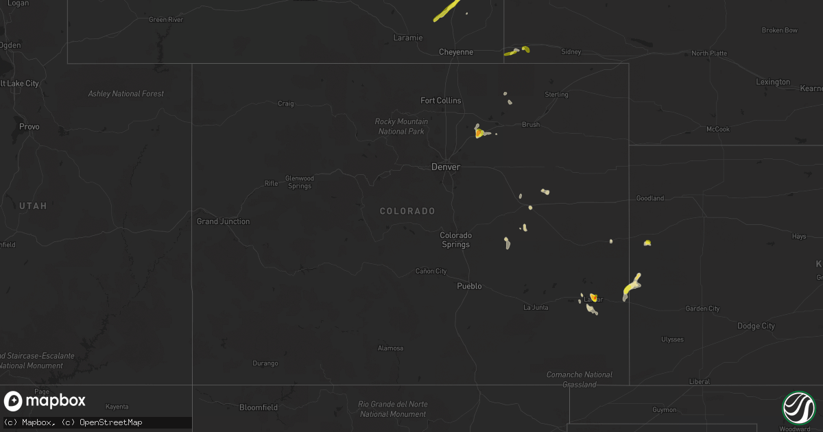
Hail Map in Colorado on June 6, 2021
Get this storm
June 6 map
$229
one time, instant access
Download today. No call, no setup
Keep the $229
Bought the map and want the full workflow? Apply the entire $229 to a subscription within 7 days. None of it is wasted.
Every map, not just this one
This buys you this map. Subscription and you get every map we run, in the markets you choose from a few cities to whole states to nationwide. Plus real-time alerts the moment a storm fires.
Contact data
Name, contact info, occupancy, even credit band for addresses in the footprint. You go from where it hit to who to call.
Become the source they trust
Unlimited branding weather history reports on demand. You already have the documented answer ready for the property owner, and you are the one who showed up with it.
Property data and RoofTrace estimates
Pull up any address you have got, its value and the exact code rules for that jurisdiction, straight from One Click Code. Then RoofTrace estimates the squares, pitch, and roof value, priced the way you price.
Storm reports in Colorado
Colorado
| Date | Description |
|---|---|
| 06/06/20216:46 AM CDT | At 1145 PM MDT, a severe thunderstorm was located 9 miles northeast of Hartman, or 12 miles north of Coolidge, moving south at 10 mph. HAZARD...60 mph wind gusts and half dollar size hail. SOURCE...Radar indicated. IMPACT...Hail damage to vehicles is expected. Expect wind damage to roofs, siding, and trees. Locations impacted include... Hartman. |
| 06/06/20215:30 AM CDT | At 1030 PM MDT, severe thunderstorms were located along a line extending from near McClave to 7 miles southwest of Lamar, moving southwest at 10 mph. HAZARD...Ping pong ball size hail and 60 mph wind gusts. SOURCE...Radar indicated. IMPACT...People and animals outdoors will be injured. Expect hail damage to roofs, siding, windows, and vehicles. Expect wind damage to roofs, siding, and trees. Locations impacted include... Hasty, John Martin Reservoir and Caddoa. |
| 06/06/20214:46 AM CDT | At 946 PM MDT, a severe thunderstorm was located near Wiley, or near Lamar, and is nearly stationary. HAZARD...60 mph wind gusts and quarter size hail. SOURCE...Radar indicated. IMPACT...Hail damage to vehicles is expected. Expect wind damage to roofs, siding, and trees. Locations impacted include... Lamar, Wiley and McClave. |
| 06/05/202111:08 PM CDT | At 408 PM MDT, a severe thunderstorm was located 4 miles northeast of Keenesburg, or 24 miles southeast of Greeley, moving southeast at 5 mph. HAZARD...60 mph wind gusts and quarter size hail. SOURCE...Radar indicated. IMPACT...Expect damage to roofs, siding, and trees. Hail damage to vehicles is expected. Locations impacted include... Keenesburg, Prospect Valley and Roggen. |
| 06/05/202111:02 PM CDT | At 401 PM MDT, a severe thunderstorm was located 7 miles southeast of Keota, or 26 miles northwest of Fort Morgan, moving southeast at 5 mph. HAZARD...60 mph wind gusts and quarter size hail. SOURCE...Radar indicated. IMPACT...Expect damage to roofs, siding, and trees. Hail damage to vehicles is expected. Locations impacted include... New Raymer. |
| 06/05/202110:54 PM CDT | A local report indicates 1.75 inch wind near LAMAR |
| 06/05/20219:19 PM CDT | At 219 PM MDT, a severe thunderstorm was located near Fountain, or 16 miles southeast of Colorado Springs, moving south at 10 mph. HAZARD...60 mph wind gusts and quarter size hail. SOURCE...Radar indicated. IMPACT...Hail damage to vehicles is expected. Expect wind damage to roofs, siding, and trees. Locations impacted include... Fountain and Hanover. |
All States Impacted by Hail Map on June 6, 2021
Cities Impacted by Hail Map on June 6, 2021
- Kingston, OK
- Madill, OK
- Quitaque, TX
- Turkey, TX
- Clarendon, TX
- Breckenridge, TX
- Graham, TX
- Woodson, TX
- Olton, TX
- Plainview, TX
- Hale Center, TX
- Hart, TX
- Fluvanna, TX
- Tahoka, TX
- Odonnell, TX
- Gail, TX
- Brownfield, TX
- Wichita Falls, TX
- Veteran, WY
- Yoder, WY
- Lingle, WY
- Tipton, OK
- Elmer, OK
- Lamar, CO
- Sand Springs, OK
- Arriba, CO
- Genoa, CO
- Bishop, GA
- Watkinsville, GA
- Bogart, GA
- Athens, GA
- Good Hope, GA
- Throckmorton, TX
- Kress, TX
- Tulia, TX
- Paducah, TX
- Chugwater, WY
- Elgin, OK
- Fletcher, OK
- Apache, OK
- Happy, TX
- Hereford, TX
- Dimmitt, TX
- Collins, GA
- Tribune, KS
- Holly, CO
- Syracuse, KS
- Childress, TX
- Cee Vee, TX
- Lone Wolf, OK
- Roosevelt, OK
- Mountain Park, OK
- Blair, OK
- Snyder, OK
- Frederick, OK
- Hollister, OK
- Silverton, TX
- Floydada, TX
- Petersburg, TX
- Keenesburg, CO
- Anadarko, OK
- Lagrange, ME
- Lamesa, TX
- Bushnell, NE
- Lawton, OK
- Medicine Park, OK
- Hugo, CO
- Matheson, CO
- Afton, TX
- Dickens, TX
- Mcadoo, TX
- Albany, TX
- Briggsdale, CO
- Cheyenne, WY
- Wheatland, WY
- Rush Springs, OK
- Ninnekah, OK
- Welch, TX
- Spur, TX
- Windthorst, TX
- Scotland, TX
- Henrietta, TX
- Limon, CO
- La Salle, CO
- Roggen, CO
- Kersey, CO
- Milo, ME
- Old Town, ME
- Mannford, OK
- Terlton, OK
- Cleveland, OK
- Aspermont, TX
- Electra, TX
- Seymour, TX
- Old Glory, TX
- Olney, TX
- Holliday, TX
- Gotebo, OK
- Cement, OK
- Crosbyton, TX
- Lockney, TX
- Sharon Springs, KS
- Okmulgee, OK
- Atoka, OK
- Wapanucka, OK
- Mcalister, NM
- Bowie, TX
- Montague, TX
- Nocona, TX
- Crowell, TX
- Matador, TX
- Weinert, TX
- Quanah, TX
- Caddo, TX
- Gurdon, AR
- Tyler, TX
- Davidson, OK
- Sentinel, OK
- Granite, OK
- Vernon, TX
- Eldorado, OK
- Caddo, OK
- Caney, OK
- Hobart, OK
- Abernathy, TX
- Rush, CO
- Hasty, CO
- Okarche, OK
- Olustee, OK
- Fieldton, TX
- Goree, TX
- Cheyenne Wells, CO
- McClave, CO
- Springlake, TX
- Roaring Springs, TX
- Littlefield, TX
- Wiley, CO
- Beggs, OK
- Mounds, OK
- Grandfield, OK
- Loveland, OK
- Kingwood, TX
- Porter, TX
- Rule, TX
- Altus, OK
- Newcastle, TX
- Amherst, TX
- Okeene, OK
- Hitchcock, OK
- Kimball, NE
- Dill City, OK
- Camden, AR
- Haskell, TX
- Eastman, GA
- San Augustine, TX
- Chireno, TX
- Nazareth, TX
- Wellington, TX
- Headrick, OK
- Arapahoe, CO
- Conchas Dam, NM
- Trementina, NM
- Iowa Park, TX
- Okemah, OK
- Sunset, TX
- Wiggins, CO
- Isabella, OK
- Earth, TX
- Seagraves, TX
- Henryetta, OK
- Munday, TX
- De Queen, AR
- Lagrange, WY
- Weldona, CO
- Alex, OK
- Torrington, WY


