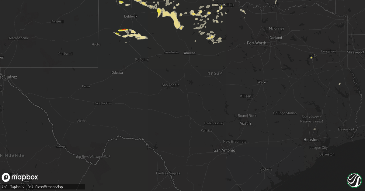
Hail Map in Texas on June 6, 2021
Get this storm
June 6 map
$229
one time, instant access
Download today. No call, no setup
Keep the $229
Bought the map and want the full workflow? Apply the entire $229 to a subscription within 7 days. None of it is wasted.
Every map, not just this one
This buys you this map. Subscription and you get every map we run, in the markets you choose from a few cities to whole states to nationwide. Plus real-time alerts the moment a storm fires.
Contact data
Name, contact info, occupancy, even credit band for addresses in the footprint. You go from where it hit to who to call.
Become the source they trust
Unlimited branding weather history reports on demand. You already have the documented answer ready for the property owner, and you are the one who showed up with it.
Property data and RoofTrace estimates
Pull up any address you have got, its value and the exact code rules for that jurisdiction, straight from One Click Code. Then RoofTrace estimates the squares, pitch, and roof value, priced the way you price.
Storm reports in Texas
Texas
| Date | Description |
|---|---|
| 06/06/20216:45 AM CDT | At 1144 PM CDT, severe thunderstorms were located along a line extending from 4 miles southwest of Vigo Park to near Hale Center, moving east at 50 mph. HAZARD...60 mph wind gusts and quarter size hail. SOURCE...Radar indicated. IMPACT...Hail damage to vehicles is expected. Expect wind damage to roofs, siding, and trees. Locations impacted include... Plainview, Floydada, Silverton, Caprock Canyon State Park, Lockney, Quitaque, South Plains, Claytonville, Dougherty, Mackenzie Reservoir, Aiken, Valley Schools and Seth Ward. |
| 06/06/20216:23 AM CDT | At 1122 PM CDT, a severe thunderstorm was located over Welch, or 16 miles northwest of Lamesa, moving east at 25 mph. HAZARD...60 mph wind gusts and quarter size hail. SOURCE...Radar indicated. IMPACT...Hail damage to vehicles is expected. Expect wind damage to roofs, siding, and trees. Locations impacted include... Welch, Hancock, Punkin Center and Arvana. |
| 06/06/20216:19 AM CDT | At 1119 PM CDT, a severe thunderstorm was located 8 miles east of Brownfield, moving east at 30 mph. HAZARD...60 mph wind gusts and quarter size hail. SOURCE...Radar indicated. IMPACT...Hail damage to vehicles is expected. Expect wind damage to roofs, siding, and trees. Locations impacted include... Tahoka, O'donnell, Grassland and New Moore. |
| 06/06/20215:59 AM CDT | At 1059 PM CDT, severe thunderstorms were located along a line extending from 10 miles southwest of Happy to near Littlefield, moving north at 5 mph. HAZARD...60 mph wind gusts and quarter size hail. SOURCE...Radar indicated. IMPACT...Hail damage to vehicles is expected. Expect wind damage to roofs, siding, and trees. Locations impacted include... Plainview, Tulia, Abernathy, Hale Center, Olton, Kress, Cotton Center, Spade, Halfway, Seth Ward and Edmonson. |
| 06/06/20215:21 AM CDT | At 1021 PM CDT, severe thunderstorms were located along a line extending from near Hart to near Littlefield, moving northeast at 10 mph. HAZARD...60 mph wind gusts and quarter size hail. SOURCE...Radar indicated. IMPACT...Hail damage to vehicles is expected. Expect wind damage to roofs, siding, and trees. Locations impacted include... Plainview, Littlefield, Hale Center, Olton, Hart, Kress, Cotton Center, Fieldton, Halfway, Spade and Edmonson. |
| 06/06/20215:18 AM CDT | At 1018 PM CDT, a severe thunderstorm was located 14 miles southwest of Happy, or 15 miles east of Dimmitt, moving east at 25 mph. HAZARD...60 mph wind gusts and quarter size hail. SOURCE...Radar indicated. IMPACT...Hail damage to vehicles is expected. Expect wind damage to roofs, siding, and trees. Locations impacted include... Tulia, Happy and Nazareth. |
| 06/06/20214:57 AM CDT | A local report indicates 1.00 inch wind near 4 WSW WICHITA FALLS |
| 06/06/20214:55 AM CDT | Relayed via mping. |
| 06/06/20214:40 AM CDT | At 940 PM CDT, severe thunderstorms were located along a line extending from near Wildorado to 7 miles southeast of Hereford, moving east at 15 mph. HAZARD...60 mph wind gusts and quarter size hail. SOURCE...Radar indicated. IMPACT...Minor damage to roofs, siding, and trees is possible. Hail damage to vehicles is expected. Locations impacted include... Amarillo, Canyon, Mescalero Park, Bushland, Buffalo Lake, Dawn, Umbarger and Timbercreek Canyon. |
| 06/06/20214:31 AM CDT | At 930 PM CDT, a severe thunderstorm was located over Easter, or 6 miles northwest of Dimmitt, moving east at 30 mph. HAZARD...60 mph wind gusts and quarter size hail. SOURCE...Radar indicated. IMPACT...Hail damage to vehicles is expected. Expect wind damage to roofs, siding, and trees. Locations impacted include... Dimmitt and Easter. |
| 06/06/20214:27 AM CDT | At 927 PM CDT, a severe thunderstorm was located 8 miles north of Earth, moving northeast at 20 mph. HAZARD...60 mph wind gusts and quarter size hail. SOURCE...Radar indicated. IMPACT...Hail damage to vehicles is expected. Expect wind damage to roofs, siding, and trees. Locations impacted include... Olton, Hart, Earth, Nazareth and Springlake. |
| 06/06/20212:54 AM CDT | At 753 PM CDT, a severe thunderstorm was located over Tyler, moving northeast at 10 mph. HAZARD...60 mph wind gusts and quarter size hail. SOURCE...Radar indicated. IMPACT...Hail damage to vehicles is expected. Expect wind damage to roofs, siding, and trees. Locations impacted include... Tyler, Winona and Red Springs. |
| 06/06/20211:36 AM CDT | At 635 PM MDT, severe wind gusts from decaying thunderstorms were located along a line extending from near Broadview to 9 miles southwest of Portales, moving east at 30 mph. HAZARD...60 mph wind gusts. SOURCE...Radar indicated. IMPACT...Expect damage to roofs, siding, and trees. Locations impacted include... Clovis, Portales, Texico, Dora, Floyd, Grady, Causey, Saint Vrain, Ranchvale and Arch.This includes Highway 60 between Mile Markers 371 and 397. |
| 06/05/20217:59 PM CDT | Quarter size hail fell a couple miles south of downtown tyler. |
All States Impacted by Hail Map on June 6, 2021
Cities Impacted by Hail Map on June 6, 2021
- Kingston, OK
- Madill, OK
- Quitaque, TX
- Turkey, TX
- Clarendon, TX
- Breckenridge, TX
- Graham, TX
- Woodson, TX
- Olton, TX
- Plainview, TX
- Hale Center, TX
- Hart, TX
- Fluvanna, TX
- Tahoka, TX
- Odonnell, TX
- Gail, TX
- Brownfield, TX
- Wichita Falls, TX
- Veteran, WY
- Yoder, WY
- Lingle, WY
- Tipton, OK
- Elmer, OK
- Lamar, CO
- Sand Springs, OK
- Arriba, CO
- Genoa, CO
- Bishop, GA
- Watkinsville, GA
- Bogart, GA
- Athens, GA
- Good Hope, GA
- Throckmorton, TX
- Kress, TX
- Tulia, TX
- Paducah, TX
- Chugwater, WY
- Elgin, OK
- Fletcher, OK
- Apache, OK
- Happy, TX
- Hereford, TX
- Dimmitt, TX
- Collins, GA
- Tribune, KS
- Holly, CO
- Syracuse, KS
- Childress, TX
- Cee Vee, TX
- Lone Wolf, OK
- Roosevelt, OK
- Mountain Park, OK
- Blair, OK
- Snyder, OK
- Frederick, OK
- Hollister, OK
- Silverton, TX
- Floydada, TX
- Petersburg, TX
- Keenesburg, CO
- Anadarko, OK
- Lagrange, ME
- Lamesa, TX
- Bushnell, NE
- Lawton, OK
- Medicine Park, OK
- Hugo, CO
- Matheson, CO
- Afton, TX
- Dickens, TX
- Mcadoo, TX
- Albany, TX
- Briggsdale, CO
- Cheyenne, WY
- Wheatland, WY
- Rush Springs, OK
- Ninnekah, OK
- Welch, TX
- Spur, TX
- Windthorst, TX
- Scotland, TX
- Henrietta, TX
- Limon, CO
- La Salle, CO
- Roggen, CO
- Kersey, CO
- Milo, ME
- Old Town, ME
- Mannford, OK
- Terlton, OK
- Cleveland, OK
- Aspermont, TX
- Electra, TX
- Seymour, TX
- Old Glory, TX
- Olney, TX
- Holliday, TX
- Gotebo, OK
- Cement, OK
- Crosbyton, TX
- Lockney, TX
- Sharon Springs, KS
- Okmulgee, OK
- Atoka, OK
- Wapanucka, OK
- Mcalister, NM
- Bowie, TX
- Montague, TX
- Nocona, TX
- Crowell, TX
- Matador, TX
- Weinert, TX
- Quanah, TX
- Caddo, TX
- Gurdon, AR
- Tyler, TX
- Davidson, OK
- Sentinel, OK
- Granite, OK
- Vernon, TX
- Eldorado, OK
- Caddo, OK
- Caney, OK
- Hobart, OK
- Abernathy, TX
- Rush, CO
- Hasty, CO
- Okarche, OK
- Olustee, OK
- Fieldton, TX
- Goree, TX
- Cheyenne Wells, CO
- McClave, CO
- Springlake, TX
- Roaring Springs, TX
- Littlefield, TX
- Wiley, CO
- Beggs, OK
- Mounds, OK
- Grandfield, OK
- Loveland, OK
- Kingwood, TX
- Porter, TX
- Rule, TX
- Altus, OK
- Newcastle, TX
- Amherst, TX
- Okeene, OK
- Hitchcock, OK
- Kimball, NE
- Dill City, OK
- Camden, AR
- Haskell, TX
- Eastman, GA
- San Augustine, TX
- Chireno, TX
- Nazareth, TX
- Wellington, TX
- Headrick, OK
- Arapahoe, CO
- Conchas Dam, NM
- Trementina, NM
- Iowa Park, TX
- Okemah, OK
- Sunset, TX
- Wiggins, CO
- Isabella, OK
- Earth, TX
- Seagraves, TX
- Henryetta, OK
- Munday, TX
- De Queen, AR
- Lagrange, WY
- Weldona, CO
- Alex, OK
- Torrington, WY


