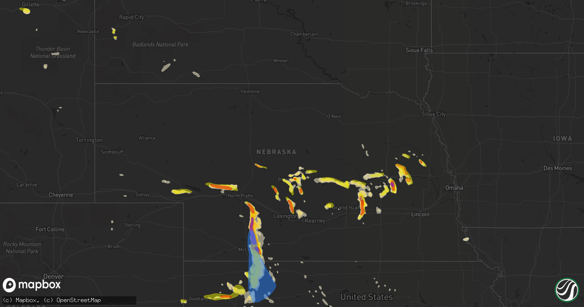
Hail Map in Nebraska on June 4, 2022
Get this storm
June 4 map
$229
one time, instant access
Download today. No call, no setup
Keep the $229
Bought the map and want the full workflow? Apply the entire $229 to a subscription within 7 days. None of it is wasted.
Every map, not just this one
This buys you this map. Subscription and you get every map we run, in the markets you choose from a few cities to whole states to nationwide. Plus real-time alerts the moment a storm fires.
Contact data
Name, contact info, occupancy, even credit band for addresses in the footprint. You go from where it hit to who to call.
Become the source they trust
Unlimited branding weather history reports on demand. You already have the documented answer ready for the property owner, and you are the one who showed up with it.
Property data and RoofTrace estimates
Pull up any address you have got, its value and the exact code rules for that jurisdiction, straight from One Click Code. Then RoofTrace estimates the squares, pitch, and roof value, priced the way you price.
Storm reports in Nebraska
Nebraska
| Date | Description |
|---|---|
| 06/04/20226:49 PM CDT | A local report indicates 2.00 inch wind near 12 E WELLFLEET |
| 06/04/20226:48 PM CDT | Hailed for over 10 minutes. |
| 06/04/20226:44 PM CDT | A local report indicates 1.00 inch wind near SCRIBNER |
| 06/04/20226:11 PM CDT | A local report indicates 1.25 inch wind near 6 N SCHUYLER |
| 06/04/20226:11 PM CDT | A local report indicates 1.50 inch wind near 4 N SCHUYLER |
| 06/04/20225:30 PM CDT | A local report indicates 1.00 inch wind near 7 WNW OCONTO |
| 06/04/20225:15 PM CDT | Report received via twitter. |
| 06/04/20226:45 AM CDT | At 1145 PM CDT, a severe thunderstorm was located near Aurora, or 20 miles west of York, moving south at 10 mph. HAZARD...Ping pong ball size hail. SOURCE...Radar indicated. IMPACT...People and animals outdoors will be injured. Expect damage to roofs, siding, windows, and vehicles. Locations impacted include... Stockham.This includes Interstate 80 between mile markers 328 and 339. |
| 06/04/20226:42 AM CDT | At 1142 PM CDT, a severe thunderstorm was located 9 miles southwest of Cairo, or 19 miles west of Grand Island, moving southeast at 15 mph. HAZARD...Half dollar size hail. SOURCE...Radar indicated. IMPACT...Damage to vehicles is expected. Locations impacted include... Shelton and Wood River.This includes Interstate 80 between mile markers 289 and 310. |
| 06/04/20226:16 AM CDT | At 1116 PM CDT, a severe thunderstorm was located over York, moving south at 15 mph. HAZARD...Half dollar size hail. SOURCE...Radar indicated. IMPACT...Damage to vehicles is expected. Locations impacted include... McCool Junction and Lushton.This includes Interstate 80 between mile markers 347 and 358. |
| 06/04/20226:06 AM CDT | At 1106 PM CDT, a severe thunderstorm was located over Aurora, or 19 miles east of Grand Island, moving south at 20 mph. HAZARD...Half dollar size hail. SOURCE...Radar indicated. IMPACT...Damage to vehicles is expected. This severe thunderstorm will be near... Aurora and Hampton around 1110 PM CDT.Other locations in the path of this severe thunderstorm includeHarvard, Saronville and Stockham.This includes Interstate 80 between mile markers 326 and 338. |
| 06/04/20225:35 AM CDT | At 1035 PM CDT, a severe thunderstorm was located over Central City, or 22 miles northeast of Grand Island, moving south at 25 mph. HAZARD...Ping pong ball size hail and 60 mph wind gusts. SOURCE...Radar indicated. IMPACT...People and animals outdoors will be injured. Expect hail damage to roofs, siding, windows, and vehicles. Expect wind damage to roofs, siding, and trees. This severe thunderstorm will be near... Marquette around 1050 PM CDT.Other locations in the path of this severe thunderstorm includeAurora and Hampton. |
| 06/04/20225:27 AM CDT | A local report indicates 1.00 inch wind near 10 E ARNOLD |
| 06/04/20225:14 AM CDT | At 1014 PM CDT, a severe thunderstorm was located over Stromsburg, or 14 miles north of York, moving south at 10 mph. HAZARD...Quarter size hail. SOURCE...Radar indicated. IMPACT...Damage to vehicles is expected. Locations impacted include... Benedict. |
| 06/04/20225:01 AM CDT | At 1001 PM CDT, a severe thunderstorm was located over Monroe, or 13 miles west of Columbus, moving east at 25 mph. HAZARD...Half dollar size hail. SOURCE...Radar indicated. IMPACT...Damage to vehicles is expected. This severe thunderstorm will be near... Platte Center around 1015 PM CDT.Other locations in the path of this severe thunderstorm includeLakeview and Columbus. |
| 06/04/20224:53 AM CDT | At 952 PM CDT, a severe thunderstorm was located near Central City, or 26 miles northeast of Grand Island, moving south at 5 mph. HAZARD...Quarter size hail. SOURCE...Radar indicated. IMPACT...Damage to vehicles is expected. This severe thunderstorm will be near... Central City around 1010 PM CDT.Other locations in the path of this severe thunderstorm includeHordville. |
| 06/04/20224:36 AM CDT | At 936 PM CDT, a severe thunderstorm was located near Elm Creek, or 16 miles northwest of Kearney, moving southeast at 15 mph. HAZARD...Quarter size hail. SOURCE...Radar indicated. IMPACT...Damage to vehicles is expected. This severe thunderstorm will be near... Amherst around 945 PM CDT. Elm Creek around 950 PM CDT.Other locations in the path of this severe thunderstorm includeOdessa and Riverdale.This includes Interstate 80 between mile markers 254 and 262. |
| 06/04/20224:12 AM CDT | At 912 PM CDT, a severe thunderstorm was located near Shelby, or 14 miles south of Columbus, moving southeast at 10 mph. HAZARD...Quarter size hail. SOURCE...Radar indicated. IMPACT...Damage to vehicles is expected. This severe thunderstorm will be near... Shelby around 925 PM CDT. |
| 06/04/20224:11 AM CDT | At 911 PM CDT, a severe thunderstorm was located near Marquette, or 20 miles east of Grand Island, moving southeast at 10 mph. HAZARD...Half dollar size hail. SOURCE...Public. IMPACT...Damage to vehicles is expected. Locations impacted include... Aurora, Hampton and Henderson.This includes Interstate 80 between mile markers 332 and 344. |
| 06/04/20224:07 AM CDT | At 907 PM CDT, a severe thunderstorm was located near Miller, or 15 miles northeast of Lexington, moving west at 10 mph. HAZARD...Quarter size hail. SOURCE...Radar indicated. IMPACT...Damage to vehicles is expected. Locations impacted include... Sumner. |
| 06/04/20224:00 AM CDT | At 859 PM CDT, a severe thunderstorm was located 8 miles northeast of Sutherland, or 18 miles northwest of North Platte, moving east at 25 mph. HAZARD...Half dollar size hail. SOURCE...Radar indicated. IMPACT...Damage to vehicles is expected. Locations impacted include... North Platte, Sutherland, Hershey, Coker, O'Fallons and Birdwood. This includes the following highways... Highway 97 between mile markers 1 and 13. Interstate 80 in Nebraska between mile markers 157 and 175. |
| 06/04/20223:58 AM CDT | At 857 PM CDT, a severe thunderstorm was located over Rising City, or 10 miles west of David City, moving south at 15 mph. HAZARD...Ping pong ball size hail and 60 mph wind gusts. SOURCE...Radar indicated. IMPACT...People and animals outdoors will be injured. Expect hail damage to roofs, siding, windows, and vehicles. Expect wind damage to roofs, siding, and trees. This severe thunderstorm will be near... Rising City around 905 PM CDT.Other locations in the path of this severe thunderstorm includeSurprise. |
| 06/04/20223:53 AM CDT | At 853 PM CDT, a severe thunderstorm was located 7 miles southwest of Sumner, or 9 miles northeast of Lexington, moving south at 15 mph. HAZARD...Ping pong ball size hail. SOURCE...Radar indicated. IMPACT...People and animals outdoors will be injured. Expect damage to roofs, siding, windows, and vehicles. This severe thunderstorm will be near... Lexington around 910 PM CDT.Other locations in the path of this severe thunderstorm includeOverton.This includes Interstate 80 between mile markers 237 and 253. |
| 06/04/20223:46 AM CDT | At 846 PM CDT, severe thunderstorms were located along a line extending from 8 miles north of Palmer to near Cushing, moving southeast at 15 mph. HAZARD...Half dollar size hail. SOURCE...Radar indicated. IMPACT...Damage to vehicles is expected. Locations impacted include... Palmer and Archer. |
| 06/04/20223:44 AM CDT | At 844 PM CDT, a severe thunderstorm was located near Scotia, or 16 miles southeast of Ord, moving east at 25 mph. HAZARD...Quarter size hail. SOURCE...Radar indicated. IMPACT...Damage to vehicles is expected. This severe thunderstorm will be near... Cotesfield around 855 PM CDT.Other locations in the path of this severe thunderstorm includeWolbach. |
| 06/04/20223:41 AM CDT | At 841 PM CDT, a severe thunderstorm was located near Danbury, or 15 miles northeast of Oberlin, moving south at 40 mph. HAZARD...Golf ball size hail and 60 mph wind gusts. SOURCE...Radar indicated. IMPACT...People and animals outdoors will be injured. Expect hail damage to roofs, siding, windows, and vehicles. Expect wind damage to roofs, siding, and trees. Locations impacted include... Norcatur, Jennings, Clayton and Dresden. |
| 06/04/20223:33 AM CDT | At 832 PM CDT, a severe thunderstorm was located 5 miles northwest of Schuyler, or 12 miles east of Columbus, moving south at 15 mph. HAZARD...Ping pong ball size hail and 60 mph wind gusts. SOURCE...Radar indicated. IMPACT...People and animals outdoors will be injured. Expect hail damage to roofs, siding, windows, and vehicles. Expect wind damage to roofs, siding, and trees. This severe thunderstorm will be near... Schuyler and Richland around 845 PM CDT.Other locations in the path of this severe thunderstorm includeOctavia. |
| 06/04/20223:27 AM CDT | At 827 PM CDT, severe thunderstorms were located along a line extending from Marquette to near Hampton, moving southeast at 10 mph. HAZARD...Quarter size hail. SOURCE...Radar indicated. IMPACT...Damage to vehicles is expected. Severe thunderstorms will be near... Hampton around 845 PM CDT.Other locations in the path of these severe thunderstorms includeAurora.This includes Interstate 80 between mile markers 335 and 346. |
| 06/04/20223:26 AM CDT | At 826 PM CDT, a severe thunderstorm was located over Rising City, or 9 miles west of David City, moving southeast at 15 mph. HAZARD...Ping pong ball size hail and 60 mph wind gusts. SOURCE...Radar indicated. IMPACT...People and animals outdoors will be injured. Expect hail damage to roofs, siding, windows, and vehicles. Expect wind damage to roofs, siding, and trees. This severe thunderstorm will be near... Rising City around 830 PM CDT.Other locations in the path of this severe thunderstorm includeSurprise and Ulysses. |
| 06/04/20223:14 AM CDT | At 814 PM CDT, a severe thunderstorm was located near Sherman Reservoir Dam, or 17 miles south of Ord, moving east at 20 mph. HAZARD...Quarter size hail. SOURCE...Radar indicated. IMPACT...Damage to vehicles is expected. This severe thunderstorm will be near... Sherman Reservoir Dam around 830 PM CDT.Other locations in the path of this severe thunderstorm includeAshton and Cotesfield. |
| 06/04/20223:13 AM CDT | At 813 PM CDT/713 PM MDT/, a severe thunderstorm was located 10 miles northwest of Sarben, or 21 miles northeast of Ogallala, moving east at 30 mph. HAZARD...Quarter size hail. SOURCE...Radar indicated. IMPACT...Damage to vehicles is expected. Locations impacted include... Big Bald Hill. |
| 06/04/20223:00 AM CDT | At 800 PM CDT, a severe thunderstorm was located 8 miles southeast of Leigh, or 15 miles northeast of Columbus, moving southeast at 15 mph. HAZARD...Ping pong ball size hail and 60 mph wind gusts. SOURCE...Radar indicated. IMPACT...People and animals outdoors will be injured. Expect hail damage to roofs, siding, windows, and vehicles. Expect wind damage to roofs, siding, and trees. Locations impacted include... Schuyler and Richland. |
| 06/04/20222:56 AM CDT | At 756 PM CDT, a severe thunderstorm was located near Bellwood, or 8 miles southeast of Columbus, moving southeast at 15 mph. HAZARD...60 mph wind gusts and half dollar size hail. SOURCE...Radar indicated. IMPACT...Hail damage to vehicles is expected. Expect wind damage to roofs, siding, and trees. Locations impacted include... David City and Rising City. |
| 06/04/20222:50 AM CDT | At 750 PM CDT, a severe thunderstorm was located 8 miles southwest of Stockville, or 15 miles south of Curtis, moving south at 25 mph. HAZARD...Golf ball size hail and 60 mph wind gusts. SOURCE...Radar indicated. IMPACT...People and animals outdoors will be injured. Expect hail damage to roofs, siding, windows, and vehicles. Expect wind damage to roofs, siding, and trees. Locations impacted include... Indianola and Bartley. |
| 06/04/20222:43 AM CDT | At 743 PM CDT, severe thunderstorms were located along a line extending from near Hordville to Central City, moving southeast at 10 mph. HAZARD...Quarter size hail. SOURCE...Radar indicated. IMPACT...Damage to vehicles is expected. Severe thunderstorms will be near... Hordville around 750 PM CDT.Other locations in the path of these severe thunderstorms includePolk and Marquette. |
| 06/04/20222:37 AM CDT | At 736 PM CDT, a severe thunderstorm was located near Stockville, or 7 miles south of Curtis, moving south at 15 mph. HAZARD...Tennis ball size hail and 60 mph wind gusts. SOURCE...Radar indicated. IMPACT...People and animals outdoors will be injured. Expect hail damage to roofs, siding, windows, and vehicles. Expect wind damage to roofs, siding, and trees. Locations impacted include... Stockville, Medicine Creek Reservoir State Recreation Area, Orafino, Freedom and Dancing Leaf Earth Lodge. |
| 06/04/20222:36 AM CDT | At 736 PM CDT, a severe thunderstorm was located near Comstock, or 11 miles west of Ord, moving east at 15 mph. HAZARD...Quarter size hail. SOURCE...Radar indicated. IMPACT...Damage to vehicles is expected. Locations impacted include... Ord and Elyria. |
| 06/04/20222:31 AM CDT | At 731 PM CDT, a severe thunderstorm was located near Indianola, or 12 miles east of McCook, and is nearly stationary. HAZARD...60 mph wind gusts and half dollar size hail. SOURCE...Radar indicated. IMPACT...Hail damage to vehicles is expected. Expect wind damage to roofs, siding, and trees. This severe thunderstorm will be near... Indianola around 735 PM CDT. Bartley around 745 PM CDT. |
| 06/04/20222:25 AM CDT | At 724 PM CDT, severe thunderstorms were located along a line extending from 8 miles west of Arcadia to 9 miles southwest of Berwyn, moving southeast at 20 mph. HAZARD...Golf ball size hail and 60 mph wind gusts. SOURCE...Radar indicated. IMPACT...People and animals outdoors will be injured. Expect hail damage to roofs, siding, windows, and vehicles. Expect wind damage to roofs, siding, and trees. Locations impacted include... Ansley, Mason City, Oconto, Berwyn, Westerville, Arcadia Diversion Dam State Wildlife Management Area, Burr Oak, Gavin Siding, Intersection of Highway 183 and Cumro Road, Buckeye, Block Hill Basin, Pressey State Wildlife Management Area and Cumro.This includes the following highways... Highway 183 between mile markers 73 and 100. Highway 2 between mile markers 286 and 307. Highway 92 between mile markers 300 and 308. |
| 06/04/20222:02 AM CDT | At 701 PM CDT, severe thunderstorms were located along a line extending from near Clarks to near Archer, moving east at 15 mph. HAZARD...Quarter size hail. SOURCE...Radar indicated. IMPACT...Damage to vehicles is expected. Severe thunderstorms will be near... Clarks around 705 PM CDT.Other locations in the path of these severe thunderstorms includeHordville, Stromsburg, Osceola, Shelby and Polk. |
| 06/04/20221:55 AM CDT | At 654 PM CDT, a severe thunderstorm was located 6 miles northeast of Clarkson, or 18 miles west of West Point, moving southeast at 15 mph. HAZARD...Ping pong ball size hail and 60 mph wind gusts. SOURCE...Radar indicated. IMPACT...People and animals outdoors will be injured. Expect hail damage to roofs, siding, windows, and vehicles. Expect wind damage to roofs, siding, and trees. Locations impacted include... Clarkson, Howells and Dodge. |
| 06/04/20221:50 AM CDT | At 650 PM CDT, a severe thunderstorm was located near Broken Bow, moving southeast at 15 mph. HAZARD...60 mph wind gusts and half dollar size hail. SOURCE...Radar indicated. IMPACT...Hail damage to vehicles is expected. Expect wind damage to roofs, siding, and trees. Locations impacted include... Broken Bow, Ansley, Berwyn and Buckeye. This includes the following highways... Highway 183 between mile markers 87 and 96. Highway 2 between mile markers 276 and 296. Highway 92 between mile markers 300 and 301. |
| 06/04/20221:43 AM CDT | At 643 PM CDT, a severe thunderstorm was located over Linwood, or 14 miles northeast of David City, moving southeast at 15 mph. HAZARD...Ping pong ball size hail and 60 mph wind gusts. SOURCE...Radar indicated. IMPACT...People and animals outdoors will be injured. Expect hail damage to roofs, siding, windows, and vehicles. Expect wind damage to roofs, siding, and trees. This severe thunderstorm will be near... Linwood around 650 PM CDT.Other locations in the path of this severe thunderstorm includePrague, Bruno and Abie. |
| 06/04/20221:43 AM CDT | At 643 PM CDT, severe thunderstorms were located along a line extending from 10 miles north of Moorefield to 7 miles east of Stockville to 7 miles northwest of Bartley, moving southeast at 20 mph. HAZARD...Ping pong ball size hail and 60 mph wind gusts. SOURCE...Radar indicated. IMPACT...People and animals outdoors will be injured. Expect hail damage to roofs, siding, windows, and vehicles. Expect wind damage to roofs, siding, and trees. Locations impacted include... Curtis, Eustis, Moorefield, Stockville, Medicine Creek Reservoir State Recreation Area, Hansen Memorial Reserve State Wildlife Management Area, Orafino, Freedom and Dancing Leaf Earth Lodge. |
| 06/04/20221:43 AM CDT | At 642 PM CDT, a severe thunderstorm was located near Mason City, or 22 miles southeast of Broken Bow, moving southeast at 20 mph. HAZARD...Quarter size hail. SOURCE...Radar indicated. IMPACT...Damage to vehicles is expected. Locations impacted include... Pleasanton. |
| 06/04/20221:36 AM CDT | At 636 PM CDT, a severe thunderstorm was located near Scribner, or 9 miles south of West Point, moving east at 15 mph. HAZARD...Ping pong ball size hail and 60 mph wind gusts. SOURCE...Radar indicated. IMPACT...People and animals outdoors will be injured. Expect hail damage to roofs, siding, windows, and vehicles. Expect wind damage to roofs, siding, and trees. This severe thunderstorm will be near... Scribner around 650 PM CDT.Other locations in the path of this severe thunderstorm includeHooper and Uehling. |
| 06/04/20221:19 AM CDT | At 618 PM CDT, a severe thunderstorm was located over Stockville, or 12 miles southeast of Curtis, moving northeast at 15 mph. HAZARD...60 mph wind gusts and half dollar size hail. SOURCE...Radar indicated. IMPACT...Hail damage to vehicles is expected. Expect wind damage to roofs, siding, and trees. Locations impacted include... Stockville, Medicine Creek Reservoir State Recreation Area, Orafino, Freedom and Dancing Leaf Earth Lodge. |
| 06/04/20221:18 AM CDT | At 618 PM CDT, a severe thunderstorm was located 9 miles west of Oconto, or 23 miles northwest of Lexington, moving south at 15 mph. HAZARD...Quarter size hail. SOURCE...Radar indicated. IMPACT...Damage to vehicles is expected. Locations impacted include... Cozad.This includes Interstate 80 between mile markers 217 and 219. |
| 06/04/20221:11 AM CDT | At 611 PM CDT, a severe thunderstorm was located near Ansley, or 15 miles southeast of Broken Bow, moving southeast at 15 mph. HAZARD...60 mph wind gusts and half dollar size hail. SOURCE...Radar indicated. IMPACT...Hail damage to vehicles is expected. Expect wind damage to roofs, siding, and trees. Locations impacted include... Ansley, Mason City, Block Hill Basin, Gavin Siding and Intersection of Highway 183 and Cumro Road.This includes the following highways... Highway 183 between mile markers 73 and 94. Highway 2 between mile markers 291 and 307. Highway 92 between mile markers 300 and 307. |
| 06/04/20221:07 AM CDT | At 607 PM CDT, a severe thunderstorm was located 10 miles southwest of Brady, or 18 miles north of Curtis, moving southeast at 15 mph. HAZARD...Two inch hail and 60 mph wind gusts. SOURCE...Radar indicated. IMPACT...People and animals outdoors will be injured. Expect hail damage to roofs, siding, windows, and vehicles. Expect wind damage to roofs, siding, and trees. Locations impacted include... Brady, Moorefield and Jeffrey Canyon State Wildlife Management Area.This includes Interstate 80 in Nebraska between mile markers 197 and205. |
| 06/04/202212:56 AM CDT | At 555 PM CDT, a severe thunderstorm was located 7 miles south of Callaway, or 20 miles southwest of Broken Bow, moving southeast at 10 mph. HAZARD...60 mph wind gusts and half dollar size hail. SOURCE...Radar indicated. IMPACT...Hail damage to vehicles is expected. Expect wind damage to roofs, siding, and trees. Locations impacted include... Callaway, Oconto, Lodi and Pressey State Wildlife Management Area. |
| 06/04/202212:52 AM CDT | At 551 PM CDT, a severe thunderstorm was located 8 miles south of Clarkson, or 17 miles northeast of Columbus, moving east at 15 mph. HAZARD...60 mph wind gusts and half dollar size hail. SOURCE...Radar indicated. IMPACT...Hail damage to vehicles is expected. Expect wind damage to roofs, siding, and trees. This severe thunderstorm will remain over mainly rural areas of eastern Colfax County, including the following locations... Rogers and Fishers Elementary. |
| 06/04/202212:49 AM CDT | At 549 PM CDT, a severe thunderstorm was located near Arcadia, or 19 miles southwest of Ord, moving east at 20 mph. HAZARD...60 mph wind gusts and quarter size hail. SOURCE...Radar indicated. IMPACT...Hail damage to vehicles is expected. Expect wind damage to roofs, siding, and trees. This severe thunderstorm will be near... Arcadia around 605 PM CDT. |
| 06/04/202212:38 AM CDT | At 538 PM CDT, severe thunderstorms were located along a line extending from 6 miles south of Halsey to 10 miles north of Gandy, moving southeast at 15 mph. HAZARD...Ping pong ball size hail and 60 mph wind gusts. SOURCE...Radar indicated. IMPACT...People and animals outdoors will be injured. Expect hail damage to roofs, siding, windows, and vehicles. Expect wind damage to roofs, siding, and trees. Locations impacted include... Arnold, Dunning, Logan, Linscott, Shanklin Bluff, Pleasant Hill, Hoagland, Brown Lake and Finchville.This includes the following highways... Highway 2 between mile markers 233 and 254. Highway 92 between mile markers 249 and 260. Highway 83 between mile markers 118 and 121. |
| 06/04/202212:36 AM CDT | At 536 PM MDT, severe thunderstorms were located along a line extending from 6 miles west of Oshkosh to 10 miles northeast of Chappell, moving east at 25 mph. HAZARD...60 mph wind gusts and half dollar size hail. SOURCE...Radar indicated. IMPACT...Hail damage to vehicles is expected. Expect wind damage to roofs, siding, and trees. Locations impacted include... Oshkosh, Lewellen, Ash Hollow State Historical Park, Eagle Gulch Campground, Ruthon, Belmar, Clear Creek State Wildlife Management Area, Intersection of Highway 27 and 9 Mile Road, Bluewater Battlefield State Historical Park, Otter Creek Campground, Windlass Hill and Lake View Campground.This includes Highway 92 between mile markers 115 and 128. |
| 06/04/202212:24 AM CDT | At 524 PM CDT, severe thunderstorms were located along a line extending from near Brady to 8 miles southeast of Lake Maloney State Recreation Area, moving east at 15 mph. HAZARD...Golf ball size hail and 60 mph wind gusts. SOURCE...Radar indicated. IMPACT...People and animals outdoors will be injured. Expect hail damage to roofs, siding, windows, and vehicles. Expect wind damage to roofs, siding, and trees. Locations impacted include... Brady, Maxwell, Jeffrey Canyon State Wildlife Management Area and Cottonwood Canyon State Wildlife Management Area.This includes the following highways... Interstate 80 in Nebraska between mile markers 187 and 204. Highway 83 between mile markers 73 and 74. |
| 06/04/202212:21 AM CDT | At 521 PM CDT, a severe thunderstorm was located near Callaway, or 20 miles southwest of Broken Bow, moving southeast at 5 mph. HAZARD...Golf ball size hail and 60 mph wind gusts. SOURCE...Radar indicated. IMPACT...People and animals outdoors will be injured. Expect hail damage to roofs, siding, windows, and vehicles. Expect wind damage to roofs, siding, and trees. Locations impacted include... Callaway and Lodi. |
| 06/04/202212:13 AM CDT | At 513 PM CDT, a severe thunderstorm was located near Berwyn, or near Broken Bow, moving southeast at 5 mph. HAZARD...60 mph wind gusts and half dollar size hail. SOURCE...Radar indicated. IMPACT...Hail damage to vehicles is expected. Expect wind damage to roofs, siding, and trees. Locations impacted include... Broken Bow, Ansley, Berwyn, Weissert and Westerville. This includes the following highways... Highway 183 between mile markers 89 and 102. Highway 2 between mile markers 279 and 295. |
| 06/04/202212:12 AM CDT | At 512 PM CDT, a severe thunderstorm was located 4 miles south of Leigh, or 16 miles northeast of Columbus, moving east at 20 mph. HAZARD...60 mph wind gusts and half dollar size hail. SOURCE...Radar indicated. IMPACT...Hail damage to vehicles is expected. Expect wind damage to roofs, siding, and trees. Locations impacted include... Clarkson. |
| 06/03/202211:41 PM CDT | At the intersection of hwy 34 and hwy 14. |
| 06/03/202211:35 PM CDT | Facebook. |
| 06/03/202211:28 PM CDT | Aurora police reports golf ball size hail in aurora. Relayed by em. |
| 06/03/202211:02 PM CDT | Facebook. |
| 06/03/202210:49 PM CDT | Facebook. |
| 06/03/202210:48 PM CDT | Facebook. |
| 06/03/202210:45 PM CDT | Corrects time of previous hail report from marquette. Report via facebook. Time estimated from radar. |
| 06/03/202210:20 PM CDT | Delayed report. |
| 06/03/20229:15 PM CDT | Facebook photo... Time between 9 and 9:15 pm. |
| 06/03/20229:02 PM CDT | A local report indicates 1.25 inch wind near RISING CITY |
| 06/03/20229:02 PM CDT | Twitter picture. |
| 06/03/20228:38 PM CDT | Off and on for 20 min. |
| 06/03/20228:30 PM CDT | A local report indicates 2.00 inch wind near 4 NNW RISING CITY |
| 06/03/20228:25 PM CDT | Corrects previous non-tstm wnd gst report from 8 nnw danbury. Mesonet station nb078 indianola 8sw. |
| 06/03/20228:19 PM CDT | Asos station kmck mccook airport. |
| 06/03/20228:18 PM CDT | Asos station kmck mccook airport. |
| 06/03/20228:15 PM CDT | A local report indicates 1.75 inch wind near 5 NE CHAPMAN |
| 06/03/20228:15 PM CDT | A local report indicates 1.50 inch wind near 5 N RISING CITY |
| 06/03/20228:00 PM CDT | A local report indicates 1.00 inch wind near 5 W BELLWOOD |
| 06/03/20228:00 PM CDT | A local report indicates 1.00 inch wind near 1 SW CENTRAL CITY |
| 06/03/20227:54 PM CDT | Another photo via social media. |
| 06/03/20227:52 PM CDT | Photo via social media. |
| 06/03/20227:51 PM CDT | Report from mping: quarter |
| 06/03/20227:37 PM CDT | A local report indicates 1.75 inch wind near INDIANOLA |
| 06/03/20227:17 PM CDT | Report received via twitter. |
| 06/03/20227:11 PM CDT | A local report indicates 1.00 inch wind near 2 NW ABIE |
All States Impacted by Hail Map on June 4, 2022
Cities Impacted by Hail Map on June 4, 2022
- Columbus, NE
- Silver Creek, NE
- Osceola, NE
- Porcupine, SD
- Cambridge, NE
- Concordia, KS
- Potter, NE
- Norton, KS
- Edna, TX
- Pine Ridge, SD
- Manderson, SD
- Arcadia, NE
- North Platte, NE
- Hershey, NE
- Paxton, NE
- Sutherland, NE
- Lolita, TX
- York, NE
- Hazelton, KS
- Vona, CO
- St John, KS
- Moorcroft, WY
- Upton, WY
- Sundance, WY
- Medicine Lodge, KS
- Sharon, KS
- Eddyville, NE
- Sumner, NE
- Oconto, NE
- Overton, NE
- Clarks, NE
- Harvard, NE
- Ord, NE
- Fullerton, NE
- Polk, NE
- Aurora, NE
- North Loup, NE
- Saint Paul, NE
- Chapman, NE
- Ashton, NE
- Archer, NE
- Hordville, NE
- Scotia, NE
- Marquette, NE
- Hampton, NE
- Central City, NE
- Palmer, NE
- Giltner, NE
- Loup City, NE
- Wolbach, NE
- Elba, NE
- Sheridan, WY
- Clearmont, WY
- Norcatur, KS
- Lenora, KS
- Howells, NE
- Clarkson, NE
- West Point, NE
- Park, KS
- Wisner, NE
- Quinter, KS
- Albert, KS
- Stoneham, CO
- Scandia, KS
- Port Arthur, TX
- Louise, TX
- Douglas, WY
- Colby, KS
- Levant, KS
- Kanorado, KS
- Comstock, NE
- Albion, NE
- Petersburg, NE
- Wakeeney, KS
- Mason City, NE
- Callaway, NE
- Merna, NE
- Ansley, NE
- Westerville, NE
- Broken Bow, NE
- Glendo, WY
- Garber, OK
- Billings, OK
- Sylvan Grove, KS
- Burdett, KS
- Alexander, KS
- Center Conway, NH
- Fryeburg, ME
- Hiram, ME
- Denmark, ME
- Madison, NH
- Sebago, ME
- Conway, NH
- Brownfield, ME
- Larned, KS
- Pawnee Rock, KS
- Wilsonville, NE
- Troy, AL
- Brundidge, AL
- Stockton, KS
- Ravenna, NE
- Shelton, NE
- Ellis, KS
- Leigh, NE
- Harrisburg, NE
- Miller, NE
- Amherst, NE
- Rexford, KS
- Gem, KS
- Atwood, KS
- Hoxie, KS
- Selden, KS
- Hoisington, KS
- Russell, KS
- Olmitz, KS
- Otis, KS
- Platte Center, NE
- Monroe, NE
- Gillette, WY
- Custer, SD
- Brewster, KS
- Natoma, KS
- Martin, SD
- Burlington, CO
- Morland, KS
- Stapleton, NE
- Newcastle, WY
- Wood River, NE
- Elm Creek, NE
- Kearney, NE
- Oberlin, KS
- Victoria, KS
- Bison, KS
- Genoa, NE
- Arnold, KS
- Utica, KS
- Hill City, SD
- Pond Creek, OK
- Hunter, OK
- Elgin, NE
- Healy, KS
- Hill City, KS
- Attica, KS
- Zenda, KS
- Sargent, NE
- Victoria, TX
- Fort Stockton, TX
- Oshkosh, NE
- Leoti, KS
- Thermopolis, WY
- Shoshoni, WY
- Hays, KS
- Liebenthal, KS
- McCracken, KS
- Schoenchen, KS
- Ogallah, KS
- La Crosse, KS
- Lysite, WY
- Woodston, KS
- Clifton, KS
- Coffeyville, KS
- Great Bend, KS
- Rising City, NE
- David City, NE
- McCook, NE
- Jennings, KS
- Bartley, NE
- Danbury, NE
- Moorefield, NE
- Lebanon, NE
- Curtis, NE
- Stockville, NE
- Indianola, NE
- Maxwell, NE
- Farnam, NE
- Dresden, KS
- Maywood, NE
- Brady, NE
- Gaylord, KS
- Alton, KS
- Penokee, KS
- Shelby, NE
- Bellwood, NE
- Big Springs, NE
- Brule, NE
- Chappell, NE
- Port Lavaca, TX
- Stromsburg, NE
- Wellfleet, NE
- Phillipsburg, KS
- Waldo, KS
- Luray, KS
- Grinnell, KS
- Gove, KS
- Perry, OK
- Isabel, KS
- Scribner, NE
- Dryden, TX
- Lenapah, OK
- Macksville, KS
- Byers, KS
- Sawyer, KS
- Iuka, KS
- Pratt, KS
- Nashville, KS
- Cunningham, KS
- Stafford, KS
- Turon, KS
- Dighton, KS
- Refugio, TX
- Schuyler, NE
- Bloomington, TX
- Inez, TX
- La Salle, TX
- Tivoli, TX
- Abie, NE
- Linwood, NE
- Bruno, NE
- Manchester, OK
- Waldron, KS
- Burlington, OK
- Amorita, OK
- Nash, OK
- Jet, OK
- Enid, OK
- Wakita, OK
- Belpre, KS
- Glade, KS
- Grainfield, KS
- Mankato, KS
- Ganado, TX
- Osborne, KS
- Rogers, NE
- Garfield, KS
- Rozel, KS
- Lewis, KS
- Ransom, KS
- Rock Port, MO
- Brownville, NE
- Nemaha, NE
- Medford, OK
- Beeville, TX
- Saint Edward, NE
- Phillips, ME
- Strong, ME
- Clyde, KS
- Kanopolis, KS
- Ellsworth, KS
- Goodland, KS
- Edson, KS
- Jackman, ME
- Pittsburg, NH
- Prague, NE
- Arnold, NE
- Hooper, NE
- Dodge, NE
- Cairo, NE
- Arvada, WY
- Clayton, KS
- Augusta, KS
- Wichita, KS
- Towanda, KS
- Andover, KS


