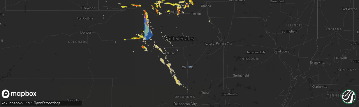
Hail Map in Kansas on June 4, 2022
The weather event in Kansas on June 4, 2022 includes Hail and Wind maps. 11 states and 263 cities were impacted and suffered possible damage. The total estimated number of properties impacted is 6,581.
Want more than just the map?
Turn this storm into a full workflow.
- Owner + property data so you know who to knock
- OnDemand branded weather history reports to win the "did we even have hail?" argument
- RoofTrace estimate so reps stop guessing numbers at the door
Bought this map? Upgrade within 7 days and we'll credit the $230. (10-15 min setup call)
Hail
Wind
6,581
Estimated number of impacted properties by a 1.00" hail or larger2,805
Estimated number of impacted properties by a 1.75" hail or larger0
Estimated number of impacted properties by a 2.50" hail or largerStorm reports in Kansas
Kansas
| Date | Description |
|---|---|
| 06/04/20226:55 PM CDT | Dime to nickel sized hail with occasional quarter sized hail reported via social media. |
| 06/04/20226:29 AM CDT | At 1128 PM CDT, a severe thunderstorm was located 13 miles west of Gove, moving southeast at 30 mph. HAZARD...Ping pong ball size hail. SOURCE...Radar indicated. IMPACT...People and animals outdoors will be injured. Expect damage to roofs, siding, windows, and vehicles. This severe thunderstorm will remain over mainly rural areas of southwestern Gove County, including the following locations... The Monument Rocks. |
| 06/04/20225:51 AM CDT | At 1051 PM CDT, a severe thunderstorm was located 10 miles west of Gove, moving southeast at 30 mph. HAZARD...Ping pong ball size hail. SOURCE...Radar indicated. IMPACT...People and animals outdoors will be injured. Expect damage to roofs, siding, windows, and vehicles. This severe thunderstorm will remain over mainly rural areas of southern Gove County. |
| 06/04/20224:43 AM CDT | At 943 PM CDT, a severe thunderstorm was located 6 miles south of Oberlin, moving south at 30 mph. HAZARD...70 mph wind gusts and ping pong ball size hail. SOURCE...Radar indicated. IMPACT...People and animals outdoors will be injured. Expect hail damage to roofs, siding, windows, and vehicles. Expect considerable tree damage. Wind damage is also likely to mobile homes, roofs, and outbuildings. This severe thunderstorm will remain over mainly rural areas of southwestern Decatur County. |
| 06/04/20224:28 AM CDT | At 928 PM CDT, severe thunderstorms were located along a line extending from 3 miles northwest of Norcatur to 4 miles southwest of Selden to 6 miles south of Gem, moving southeast at 35 mph. HAZARD...Golf ball size hail and 70 mph wind gusts. SOURCE...Radar indicated. IMPACT...People and animals outdoors will be injured. Expect hail damage to roofs, siding, windows, and vehicles. Expect considerable tree damage. Wind damage is also likely to mobile homes, roofs, and outbuildings. Severe thunderstorms will be near... Clayton around 940 PM CDT.Other locations in the path of these severe thunderstorms includeHoxie, Grinnell, Lenora, Grainfield, Edmond, Gove and Park.This includes Interstate 70 in Kansas between mile markers 58 and111. |
| 06/04/20224:16 AM CDT | At 915 PM CDT, a severe thunderstorm was located 4 miles southwest of Oberlin, moving south at 30 mph. HAZARD...70 mph wind gusts and ping pong ball size hail. SOURCE...Radar indicated. IMPACT...People and animals outdoors will be injured. Expect hail damage to roofs, siding, windows, and vehicles. Expect considerable tree damage. Wind damage is also likely to mobile homes, roofs, and outbuildings. This severe thunderstorm will remain over mainly rural areas of southwestern Decatur County. |
| 06/04/20224:08 AM CDT | At 908 PM CDT, a severe thunderstorm was located 13 miles south of Atwood, moving east at 10 mph. HAZARD...Ping pong ball size hail. SOURCE...Radar indicated. IMPACT...People and animals outdoors will be injured. Expect damage to roofs, siding, windows, and vehicles. This severe thunderstorm will remain over mainly rural areas of northeastern Thomas and southeastern Rawlins Counties. |
| 06/04/20224:04 AM CDT | At 904 PM CDT, a severe thunderstorm was located 4 miles east of Colby, moving east at 30 mph. HAZARD...60 mph wind gusts and half dollar size hail. SOURCE...Trained weather spotters. IMPACT...Hail damage to vehicles is expected. Expect wind damage to roofs, siding, and trees. Locations impacted include... Rexford and Menlo.This includes Interstate 70 in Kansas between mile markers 47 and 71. |
| 06/04/20223:55 AM CDT | A local report indicates 66 MPH wind near JABARA AIRPORT |
| 06/04/20222:55 AM CDT | At 754 PM CDT, a severe thunderstorm was located 6 miles southeast of Indianola, or 14 miles east of McCook, moving south at 30 mph. HAZARD...Tennis ball size hail and 60 mph wind gusts. SOURCE...Trained weather spotters. IMPACT...People and animals outdoors will be injured. Expect hail damage to roofs, siding, windows, and vehicles. Expect wind damage to roofs, siding, and trees. This severe thunderstorm will be near... Danbury and Lebanon around 810 PM CDT. |
| 06/04/20222:25 AM CDT | At 725 PM MDT/825 PM CDT/, a severe thunderstorm was located 5 miles west of Brewster, moving southeast at 15 mph. HAZARD...60 mph wind gusts and quarter size hail. SOURCE...Radar indicated. IMPACT...Hail damage to vehicles is expected. Expect wind damage to roofs, siding, and trees. This severe thunderstorm will be near... Brewster around 840 PM CDT.This includes Interstate 70 in Kansas between mile markers 21 and 49. |
| 06/04/202212:13 AM CDT | A local report indicates 58 MPH wind near RUSSELL AIRPORT |
| 06/04/202212:10 AM CDT | 10-meter wind gust from the kansas state mesonet station hask1 hays. |
| 06/03/202210:10 PM CDT | Law enforcement estimated 60 mph winds as storms moved through town. |
| 06/03/20229:59 PM CDT | Site kkshoxie16. |
| 06/03/20229:59 PM CDT | Site kksclayt3. |
| 06/03/20229:11 PM CDT | Davis station 9 feet agl measured 65 mph gust. 60 mph gust prior to this at 9:05 local time. |
| 06/03/20229:07 PM CDT | Trained spotter reported ping pong sized hail. |
| 06/03/20229:02 PM CDT | Quarter sized hail reported at location via social media. |
| 06/03/20229:01 PM CDT | Few lopsided golf ball sized hail reported at location via social media. |
| 06/03/20229:01 PM CDT | Tornado lasted 2-3 minutes then ended. Located near the intersection of hwy 83/road 348. |
| 06/03/20229:00 PM CDT | Ks mesonet site reported 10m wind gust of 72 mph at location. |
| 06/03/20228:51 PM CDT | Site huff weather station. |
| 06/03/20228:30 PM CDT | Quarter sized hail with lots of pea to dime sized hail reported via social media. |
All States Impacted by Hail Map on June 4, 2022
Cities Impacted by Hail Map on June 4, 2022
- Columbus, NE
- Silver Creek, NE
- Osceola, NE
- Porcupine, SD
- Cambridge, NE
- Concordia, KS
- Potter, NE
- Norton, KS
- Edna, TX
- Pine Ridge, SD
- Manderson, SD
- Arcadia, NE
- North Platte, NE
- Hershey, NE
- Paxton, NE
- Sutherland, NE
- Lolita, TX
- York, NE
- Hazelton, KS
- Vona, CO
- St John, KS
- Moorcroft, WY
- Upton, WY
- Sundance, WY
- Medicine Lodge, KS
- Sharon, KS
- Eddyville, NE
- Sumner, NE
- Oconto, NE
- Overton, NE
- Clarks, NE
- Harvard, NE
- Ord, NE
- Fullerton, NE
- Polk, NE
- Aurora, NE
- North Loup, NE
- Saint Paul, NE
- Chapman, NE
- Ashton, NE
- Archer, NE
- Hordville, NE
- Scotia, NE
- Marquette, NE
- Hampton, NE
- Central City, NE
- Palmer, NE
- Giltner, NE
- Loup City, NE
- Wolbach, NE
- Elba, NE
- Sheridan, WY
- Clearmont, WY
- Norcatur, KS
- Lenora, KS
- Howells, NE
- Clarkson, NE
- West Point, NE
- Park, KS
- Wisner, NE
- Quinter, KS
- Albert, KS
- Stoneham, CO
- Scandia, KS
- Port Arthur, TX
- Louise, TX
- Douglas, WY
- Colby, KS
- Levant, KS
- Kanorado, KS
- Comstock, NE
- Albion, NE
- Petersburg, NE
- Wakeeney, KS
- Mason City, NE
- Callaway, NE
- Merna, NE
- Ansley, NE
- Westerville, NE
- Broken Bow, NE
- Glendo, WY
- Garber, OK
- Billings, OK
- Sylvan Grove, KS
- Burdett, KS
- Alexander, KS
- Center Conway, NH
- Fryeburg, ME
- Hiram, ME
- Denmark, ME
- Madison, NH
- Sebago, ME
- Conway, NH
- Brownfield, ME
- Larned, KS
- Pawnee Rock, KS
- Wilsonville, NE
- Troy, AL
- Brundidge, AL
- Stockton, KS
- Ravenna, NE
- Shelton, NE
- Ellis, KS
- Leigh, NE
- Harrisburg, NE
- Miller, NE
- Amherst, NE
- Rexford, KS
- Gem, KS
- Atwood, KS
- Hoxie, KS
- Selden, KS
- Hoisington, KS
- Russell, KS
- Olmitz, KS
- Otis, KS
- Platte Center, NE
- Monroe, NE
- Gillette, WY
- Custer, SD
- Brewster, KS
- Natoma, KS
- Martin, SD
- Burlington, CO
- Morland, KS
- Stapleton, NE
- Newcastle, WY
- Wood River, NE
- Elm Creek, NE
- Kearney, NE
- Oberlin, KS
- Victoria, KS
- Bison, KS
- Genoa, NE
- Arnold, KS
- Utica, KS
- Hill City, SD
- Pond Creek, OK
- Hunter, OK
- Elgin, NE
- Healy, KS
- Hill City, KS
- Attica, KS
- Zenda, KS
- Sargent, NE
- Victoria, TX
- Fort Stockton, TX
- Oshkosh, NE
- Leoti, KS
- Thermopolis, WY
- Shoshoni, WY
- Hays, KS
- Liebenthal, KS
- McCracken, KS
- Schoenchen, KS
- Ogallah, KS
- La Crosse, KS
- Lysite, WY
- Woodston, KS
- Clifton, KS
- Coffeyville, KS
- Great Bend, KS
- Rising City, NE
- David City, NE
- McCook, NE
- Jennings, KS
- Bartley, NE
- Danbury, NE
- Moorefield, NE
- Lebanon, NE
- Curtis, NE
- Stockville, NE
- Indianola, NE
- Maxwell, NE
- Farnam, NE
- Dresden, KS
- Maywood, NE
- Brady, NE
- Gaylord, KS
- Alton, KS
- Penokee, KS
- Shelby, NE
- Bellwood, NE
- Big Springs, NE
- Brule, NE
- Chappell, NE
- Port Lavaca, TX
- Stromsburg, NE
- Wellfleet, NE
- Phillipsburg, KS
- Waldo, KS
- Luray, KS
- Grinnell, KS
- Gove, KS
- Perry, OK
- Isabel, KS
- Scribner, NE
- Dryden, TX
- Lenapah, OK
- Macksville, KS
- Byers, KS
- Sawyer, KS
- Iuka, KS
- Pratt, KS
- Nashville, KS
- Cunningham, KS
- Stafford, KS
- Turon, KS
- Dighton, KS
- Refugio, TX
- Schuyler, NE
- Bloomington, TX
- Inez, TX
- La Salle, TX
- Tivoli, TX
- Abie, NE
- Linwood, NE
- Bruno, NE
- Manchester, OK
- Waldron, KS
- Burlington, OK
- Amorita, OK
- Nash, OK
- Jet, OK
- Enid, OK
- Wakita, OK
- Belpre, KS
- Glade, KS
- Grainfield, KS
- Mankato, KS
- Ganado, TX
- Osborne, KS
- Rogers, NE
- Garfield, KS
- Rozel, KS
- Lewis, KS
- Ransom, KS
- Rock Port, MO
- Brownville, NE
- Nemaha, NE
- Medford, OK
- Beeville, TX
- Saint Edward, NE
- Phillips, ME
- Strong, ME
- Clyde, KS
- Kanopolis, KS
- Ellsworth, KS
- Goodland, KS
- Edson, KS
- Jackman, ME
- Pittsburg, NH
- Prague, NE
- Arnold, NE
- Hooper, NE
- Dodge, NE
- Cairo, NE
- Arvada, WY
- Clayton, KS
- Augusta, KS
- Wichita, KS
- Towanda, KS
- Andover, KS


