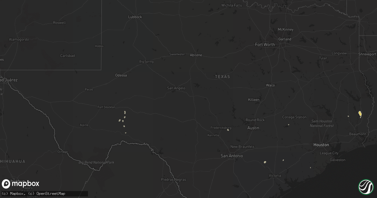
Hail Map in Texas on June 3, 2021
Get this storm
June 3 map
$229
one time, instant access
Download today. No call, no setup
Keep the $229
Bought the map and want the full workflow? Apply the entire $229 to a subscription within 7 days. None of it is wasted.
Every map, not just this one
This buys you this map. Subscription and you get every map we run, in the markets you choose from a few cities to whole states to nationwide. Plus real-time alerts the moment a storm fires.
Contact data
Name, contact info, occupancy, even credit band for addresses in the footprint. You go from where it hit to who to call.
Become the source they trust
Unlimited branding weather history reports on demand. You already have the documented answer ready for the property owner, and you are the one who showed up with it.
Property data and RoofTrace estimates
Pull up any address you have got, its value and the exact code rules for that jurisdiction, straight from One Click Code. Then RoofTrace estimates the squares, pitch, and roof value, priced the way you price.
Storm reports in Texas
Texas
| Date | Description |
|---|---|
| 06/03/20213:33 PM CDT | Mobile home sustained roof damage with pieces of sheet metal laying around the yard. Two trees around a foot in diameter snapped at this location. |
| 06/03/20213:33 PM CDT | Social media post of tree down on a house off trout street near kirbyville. |
| 06/03/202112:54 PM CDT | Roof at nelson chiropractor on e. 8th street in deer park damaged. Time is estimated based on radar. |
| 06/03/20217:10 AM CDT | At 1210 AM CDT, a severe thunderstorm was located near Bellville, moving southeast at 30 mph. HAZARD...Quarter size hail. SOURCE...Radar indicated. IMPACT...Damage to vehicles is expected. Locations impacted include... Sealy, Bellville, San Felipe, Pattison and Monaville. |
| 06/03/20213:03 AM CDT | At 803 PM CDT, National Weather Service Doppler radar indicated severe thunderstorms located along a line extending from near Viboras to La Rosita, moving southeast at 10 mph. HAZARD...60 mph wind gusts and penny size hail. SOURCE...Radar indicated. IMPACT...Expect damage to roofs, siding, and trees. Locations impacted include... Rio Grande City, Roma, Escobares, El Sauz, Viboras, Garciasville, La Rosita, La Victoria, Los Alvarez and Fort Ringgold County Park.This includes US Highway 83 between Mile Markers 808 and 832. |
| 06/03/20212:07 AM CDT | At 706 PM CDT, a severe thunderstorm was located near La Victoria, moving north at 10 mph. HAZARD...60 mph wind gusts and quarter size hail. SOURCE...Radar indicated. IMPACT...Hail damage to vehicles is expected. Expect wind damage to roofs, siding, and trees. Locations impacted include... La Victoria. |
| 06/02/202110:30 PM CDT | At 329 PM CDT, a severe thunderstorm was located over Mt. Union, or near Kirbyville, moving northwest at 5 mph. HAZARD...60 mph wind gusts and quarter size hail. SOURCE...Radar indicated. IMPACT...Hail damage to vehicles is expected. Expect wind damage to roofs, siding, and trees. Locations impacted include... Jasper, Kirbyville, Spurger, Magnolia Springs and Mt. Union. |
All States Impacted by Hail Map on June 3, 2021
Cities Impacted by Hail Map on June 3, 2021
- Canon, GA
- Bowersville, GA
- Hartwell, GA
- Princeton, OR
- Jennings, LA
- Roanoke, LA
- Welsh, LA
- Somerville, TX
- Kirbyville, TX
- Cuero, TX
- Whitley City, KY
- Manchester, TN
- Rio Grande City, TX
- Fort Stockton, TX
- Hereford, OR
- Heflin, AL
- Muscadine, AL
- Hastings, FL
- East Palatka, FL
- Dryden, TX
- Woodstock, MD
- Randallstown, MD
- Windsor Mill, MD
- Boyds, MD
- Prosperity, SC
- Leesville, SC
- Batesburg, SC
- Williamsburg, KY
- Billingsley, AL
- Verbena, AL
- Montgomery Village, MD
- Derwood, MD
- Germantown, MD
- Gaithersburg, MD
- Washington Grove, MD
- Rockville, MD
- Lutherville Timonium, MD
- Glen Arm, MD
- Towson, MD
- Parkville, MD
- Baltimore, MD
- Pikesville, MD
- Burns, OR
- Bluemont, VA
- Paris, VA
- Boyce, VA
- Black Eagle, MT
- Great Falls, MT
- Moody, AL
- Yoakum, TX
- Bel Air, MD
- Fallston, MD
- Stonewall, TX
- Leesburg, VA
- Dickerson, MD
- Anderson, SC
- Starr, SC
- Parkers Lake, KY
- Camden, AL
- Sand Coulee, MT
- Belt, MT
- Deridder, LA
- Poolesville, MD
- Deatsville, AL
- Marbury, AL
- Springer, NM
- Odenville, AL
- Kingsville, MD
- Fork, MD
- Hydes, MD
- Churchville, MD
- Baldwin, MD
- Joppa, MD
- Cockeysville, MD
- Saluda, SC
- Johnston, SC
- Hallettsville, TX
- Rockholds, KY
- Stockett, MT
- Sterrett, AL
- Brookeville, MD
- Olney, MD
- Sweeny, TX
- Phoenix, MD
- Mayhill, NM
- Cambridge, ID
- Guyton, GA
- Warren, TX
- Pine Knot, KY
- Stearns, KY
- Strunk, KY
- Waco, GA
- Fruithurst, AL
- Tallapoosa, GA
- Oakdale, LA
- Chickamauga, GA
- Rock Spring, GA
- La Fayette, GA
- Ringgold, GA
- Berryville, VA
- Barbourville, KY
- Egg Harbor Township, NJ
- Mays Landing, NJ
- Woodbine, NJ
- Cedarville, NJ
- Millville, NJ
- Bridgeton, NJ
- Mullins, SC


