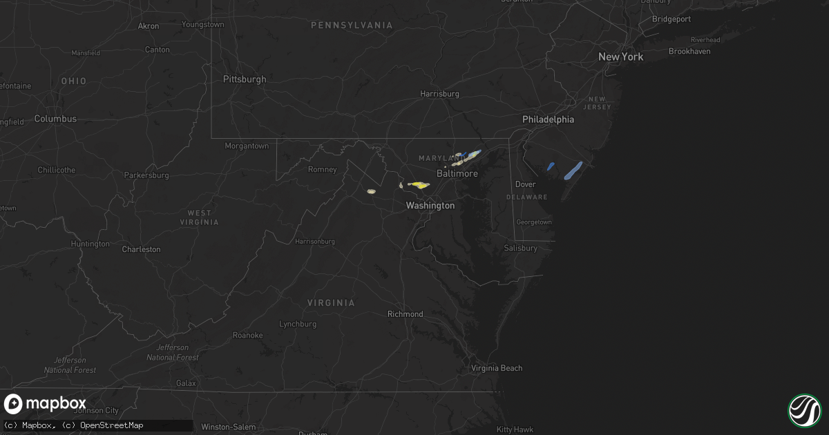
Hail Map in Maryland on June 3, 2021
Get this storm
June 3 map
$229
one time, instant access
Download today. No call, no setup
Keep the $229
Bought the map and want the full workflow? Apply the entire $229 to a subscription within 7 days. None of it is wasted.
Every map, not just this one
This buys you this map. Subscription and you get every map we run, in the markets you choose from a few cities to whole states to nationwide. Plus real-time alerts the moment a storm fires.
Contact data
Name, contact info, occupancy, even credit band for addresses in the footprint. You go from where it hit to who to call.
Become the source they trust
Unlimited branding weather history reports on demand. You already have the documented answer ready for the property owner, and you are the one who showed up with it.
Property data and RoofTrace estimates
Pull up any address you have got, its value and the exact code rules for that jurisdiction, straight from One Click Code. Then RoofTrace estimates the squares, pitch, and roof value, priced the way you price.
Storm reports in Maryland
Maryland
| Date | Description |
|---|---|
| 06/03/20216:03 PM CDT | Structural damage to a garage and five trees down in the 2000 block of churchville road. |
| 06/03/20215:57 PM CDT | A few trees blew down on cherokee lane. |
| 06/03/20215:54 PM CDT | A couple trees blew down on patterson mill road. |
| 06/03/20215:54 PM CDT | Concentration of tree damage along prospect mill road and thomas run road. Corrected time. |
| 06/03/20215:33 PM CDT | Tree reported down on ivy terrace near cozy lane |
| 06/03/20215:13 PM CDT | Tree and wires down near the intersection of germantown road and clarksburg road |
| 06/03/20215:05 PM CDT | Several trees blew down on ebenezer church road. |
| 06/03/20214:58 PM CDT | Tree down near the intersection of md-117 and clopper road |
| 06/03/20214:54 PM CDT | Concentration of tree damage along prospect mill road and thomas run road |
| 06/03/20214:53 PM CDT | Tree blew down on burlin road near dr. Jack road. |
| 06/03/20214:50 PM CDT | Two trees blew down on rock run road near the intersection of rolling hills ranch lane. |
| 06/03/20214:40 PM CDT | A local report indicates 1.00 inch wind near 3 E GAITHERSBURG |
| 06/03/20214:33 PM CDT | Tree down blocking both directions of route 28 just west of cattail road |
| 06/03/20214:04 PM CDT | Powerline wires down near the intersection of kincaid road and manor road |
| 06/03/20214:04 PM CDT | Numerous trees down off hillendale heights road across from jacksonville elementary |
| 06/03/20214:01 PM CDT | Tree down near rt 145 and greene rd |
| 06/03/20213:58 PM CDT | Numerous trees down near the intersection of sweet air road and manor road |
| 06/03/20213:58 PM CDT | Concentration of tree damage along overshot court. County 911 estimates dozens of trees damaged. |
| 06/03/20213:54 PM CDT | Tree down near the intersection of church lane and greenwood road |
| 06/03/20213:51 PM CDT | Nws storm survey team confirms ef-1 tornado in jacksonville... Md... On thursday june 3... 2021. Time 451-455 pm edt... Estimated peak winds 95 mph... Path length 2.0 m |
| 06/03/20213:50 PM CDT | Tree down on house on the 14000 block of robcaste road |
| 06/03/20213:49 PM CDT | Tree down in road near intersection of woodholme avenue and reisterstown road |
| 06/03/20213:45 PM CDT | A local report indicates 1.00 inch wind near 2 ENE LOCHEARN |
| 06/03/20213:27 PM CDT | Tree reported down 1300 block raincliffe road. |
| 06/03/20213:27 PM CDT | Tree reported down on cherry tree lane near bartholow road. |
| 06/03/20213:24 PM CDT | Tree reported down on the 600 block of river road. |
| 06/03/20213:12 PM CDT | Tree reported down on the 7500 block of john pickett road. |
| 06/03/20211:36 AM CDT | At 636 PM EDT, a severe thunderstorm was located over Kingsville, or 8 miles north of Middle River, moving northeast at 20 mph. HAZARD...60 mph wind gusts and quarter size hail. SOURCE...Radar indicated. IMPACT...Damaging winds will cause some trees and large branches to fall. This could injure those outdoors, as well as damage homes and vehicles. Roadways may become blocked by downed trees. Localized power outages are possible. Unsecured light objects may become projectiles. Locations impacted include... Bel Air South, Bel Air North, Fallston, Riverside, Kingsville, Pleasant Hills, Fork, Benson, Baldwin, Bynum, Harford Furnace, Upper Falls, Hickory and Churchville. |
| 06/03/20211:14 AM CDT | At 614 PM EDT, a severe thunderstorm was located near Bel Air South, or 7 miles northwest of Aberdeen, moving northeast at 25 mph. HAZARD...60 mph wind gusts and quarter size hail. SOURCE...Radar indicated. IMPACT...Damaging winds will cause some trees and large branches to fall. This could injure those outdoors, as well as damage homes and vehicles. Roadways may become blocked by downed trees. Localized power outages are possible. Unsecured light objects may become projectiles. Locations impacted include... Calvert, Bel Air South, Bel Air North, Rising Sun, Zion, Blake, Lombard, Richardsmere, Woodlawn, West Nottingham, Octoraro, Conowingo, Rock Springs, Fair Hill, Farmington, Port Deposit, Darlington, Churchville, Carsins and Hickory. |
| 06/03/20211:03 AM CDT | At 603 PM EDT, a severe thunderstorm was located near Olney, moving east at 30 mph. HAZARD...60 mph wind gusts. SOURCE...Radar indicated. IMPACT...Damaging winds will cause some trees and large branches to fall. This could injure those outdoors, as well as damage homes and vehicles. Roadways may become blocked by downed trees. Localized power outages are possible. Unsecured light objects may become projectiles. Locations impacted include... Columbia, Bowie, Severn, Olney, Crofton, Beltsville, Elkridge, Baltimore-Washington Airport, Glen Burnie, Aspen Hill, Odenton, Laurel, Fairland, Ferndale, Colesville, Fort Meade, Millersville, Savage-guilford, South Gate and Rossmoor. |
| 06/03/202112:27 AM CDT | At 526 PM EDT, a severe thunderstorm was located over Germantown, moving east at 35 mph. HAZARD...60 mph wind gusts and quarter size hail. SOURCE...Radar indicated. IMPACT...Damaging winds will cause some trees and large branches to fall. This could injure those outdoors, as well as damage homes and vehicles. Roadways may become blocked by downed trees. Localized power outages are possible. Unsecured light objects may become projectiles. Locations impacted include... Columbia, Germantown, Rockville, Gaithersburg, Olney, Damascus, Ellicott City, Aspen Hill, Montgomery Village, North Potomac, Fairland, Redland, Boyds, Rossmoor, Scaggsville, Cloverly, Clarksburg, Burtonsville, Darnestown and Derwood. |
| 06/03/202112:26 AM CDT | At 525 PM EDT, severe thunderstorms were located along a line extending from near Octoraro to near Bel Air South to Kingsville, moving east at 25 mph. HAZARD...60 mph wind gusts and quarter size hail. SOURCE...Radar indicated. IMPACT...Damaging winds will cause some trees and large branches to fall. This could injure those outdoors, as well as damage homes and vehicles. Roadways may become blocked by downed trees. Localized power outages are possible. Unsecured light objects may become projectiles. Locations impacted include... Aberdeen, Havre De Grace, Aberdeen Proving Ground, Calvert, Bel Air South, Bel Air North, White Marsh, Riverside, Kingsville, North East, Pleasant Hills, Rising Sun, Perryman, Charlestown, Zion, Blake, West Nottingham, Octoraro, Fair Hill and Bay View. |
| 06/02/202111:54 PM CDT | At 454 PM EDT, severe thunderstorms were located along a line extending from near Point Of Rocks to near Leesburg to near Oatlands, moving east at 25 mph. HAZARD...60 mph wind gusts and quarter size hail. SOURCE...Radar indicated. IMPACT...Damaging winds will cause some trees and large branches to fall. This could injure those outdoors, as well as damage homes and vehicles. Roadways may become blocked by downed trees. Localized power outages are possible. Unsecured light objects may become projectiles. Locations impacted include... Germantown, Leesburg, Lansdowne, Lowes Island, Poolesville, Ashburn, Great Falls, Countryside, Boyds, Clarksburg, Darnestown, Belmont, Barnesville, Paeonian Springs, Waterford, Lucketts, Dickerson, Beallsville, Dawsonville and Tuscarora. |
| 06/02/202111:43 PM CDT | At 443 PM EDT, severe thunderstorms were located along a line extending from near Jarrettsville to Cockeysville to Randallstown, moving east at 20 mph. HAZARD...60 mph wind gusts and quarter size hail. SOURCE...Radar indicated. IMPACT...Damaging winds will cause some trees and large branches to fall. This could injure those outdoors, as well as damage homes and vehicles. Roadways may become blocked by downed trees. Localized power outages are possible. Unsecured light objects may become projectiles. Locations impacted include... Baltimore, Pikesville, Middle River, Cockeysville, Towson, Bel Air South, Parkville, Bel Air North, Carney, Milford Mill, Perry Hall, Lochearn, Rosedale, Rossville, Mays Chapel, Timonium, White Marsh, Fallston, Hampton and Kingsville. |
| 06/02/202111:20 PM CDT | At 420 PM EDT, a severe thunderstorm was located over Sykesville, or 11 miles northwest of Historic Ellicott City, moving east at 30 mph. HAZARD...60 mph wind gusts and quarter size hail. SOURCE...Radar indicated. IMPACT...Damaging winds will cause some trees and large branches to fall. This could injure those outdoors, as well as damage homes and vehicles. Roadways may become blocked by downed trees. Localized power outages are possible. Unsecured light objects may become projectiles. Locations impacted include... Baltimore, Pikesville, Cockeysville, Ellicott City, Towson, Woodlawn, Randallstown, Owings Mills, Eldersburg, Milford Mill, Reisterstown, Lochearn, Mays Chapel, Timonium, Sykesville, Oakland, Lutherville-Timonium, Garrison, Lutherville and Henryton. |
| 06/02/202111:12 PM CDT | At 411 PM EDT, a severe thunderstorm was located over Reisterstown, or near Pikesville, moving northeast at 20 mph. HAZARD...60 mph wind gusts and quarter size hail. SOURCE...Radar indicated. IMPACT...Damaging winds will cause some trees and large branches to fall. This could injure those outdoors, as well as damage homes and vehicles. Roadways may become blocked by downed trees. Localized power outages are possible. Unsecured light objects may become projectiles. Locations impacted include... Cockeysville, Owings Mills, Reisterstown, Mays Chapel, Timonium, Lutherville-Timonium, Garrison, Glencoe, Hunt Valley, Glyndon, Sparks, Boring, Bentley Springs, Parkton, Phoenix, Hereford, Jacksonville, Butler and Monkton. |
| 06/02/202110:50 PM CDT | At 349 PM EDT, a severe thunderstorm was located near Charles Town, moving east at 30 mph. HAZARD...60 mph wind gusts and quarter size hail. SOURCE...Radar indicated. IMPACT...Damaging winds will cause some trees and large branches to fall. This could injure those outdoors, as well as damage homes and vehicles. Roadways may become blocked by downed trees. Localized power outages are possible. Unsecured light objects may become projectiles. Locations impacted include... Charles Town, Shepherdstown, Brunswick, Ranson, Boonsboro, Harpers Ferry, Kearneysville, Corporation Of Ranson, Lovettsville, Keedysville, Bolivar, Sharpsburg, Shenandoah Junction, Middleway, Rosemont, Rohrersville, Burkittsville, Gapland, Brownsville and Antietam. |
| 06/02/202110:47 PM CDT | At 347 PM EDT, a severe thunderstorm was located near Damascus, moving east at 25 mph. HAZARD...60 mph wind gusts and quarter size hail. SOURCE...Radar indicated. IMPACT...Damaging winds will cause some trees and large branches to fall. This could injure those outdoors, as well as damage homes and vehicles. Roadways may become blocked by downed trees. Localized power outages are possible. Unsecured light objects may become projectiles. Locations impacted include... Columbia, Germantown, Damascus, Eldersburg, Mount Airy, Sykesville, Green Valley, Clarksburg, Monrovia, Laytonsville, Clarksville, West Friendship, Winfield, Lisbon, Glenwood, Dayton, Gaither, Watersville, Poplar Springs and Roxbury Mills. |
| 06/02/202110:14 PM CDT | At 314 PM EDT, a severe thunderstorm was located near Point Of Rocks, or near Poolesville, moving east at 25 mph. HAZARD...60 mph wind gusts and quarter size hail. SOURCE...Radar indicated. IMPACT...Damaging winds will cause some trees and large branches to fall. This could injure those outdoors, as well as damage homes and vehicles. Roadways may become blocked by downed trees. Localized power outages are possible. Unsecured light objects may become projectiles. Locations impacted include... Germantown, Boyds, Clarksburg, Adamstown, Monrovia, Barnesville, Dickerson, Beallsville, Tuscarora, Lucketts and Park Mills. |
All States Impacted by Hail Map on June 3, 2021
Cities Impacted by Hail Map on June 3, 2021
- Canon, GA
- Bowersville, GA
- Hartwell, GA
- Princeton, OR
- Jennings, LA
- Roanoke, LA
- Welsh, LA
- Somerville, TX
- Kirbyville, TX
- Cuero, TX
- Whitley City, KY
- Manchester, TN
- Rio Grande City, TX
- Fort Stockton, TX
- Hereford, OR
- Heflin, AL
- Muscadine, AL
- Hastings, FL
- East Palatka, FL
- Dryden, TX
- Woodstock, MD
- Randallstown, MD
- Windsor Mill, MD
- Boyds, MD
- Prosperity, SC
- Leesville, SC
- Batesburg, SC
- Williamsburg, KY
- Billingsley, AL
- Verbena, AL
- Montgomery Village, MD
- Derwood, MD
- Germantown, MD
- Gaithersburg, MD
- Washington Grove, MD
- Rockville, MD
- Lutherville Timonium, MD
- Glen Arm, MD
- Towson, MD
- Parkville, MD
- Baltimore, MD
- Pikesville, MD
- Burns, OR
- Bluemont, VA
- Paris, VA
- Boyce, VA
- Black Eagle, MT
- Great Falls, MT
- Moody, AL
- Yoakum, TX
- Bel Air, MD
- Fallston, MD
- Stonewall, TX
- Leesburg, VA
- Dickerson, MD
- Anderson, SC
- Starr, SC
- Parkers Lake, KY
- Camden, AL
- Sand Coulee, MT
- Belt, MT
- Deridder, LA
- Poolesville, MD
- Deatsville, AL
- Marbury, AL
- Springer, NM
- Odenville, AL
- Kingsville, MD
- Fork, MD
- Hydes, MD
- Churchville, MD
- Baldwin, MD
- Joppa, MD
- Cockeysville, MD
- Saluda, SC
- Johnston, SC
- Hallettsville, TX
- Rockholds, KY
- Stockett, MT
- Sterrett, AL
- Brookeville, MD
- Olney, MD
- Sweeny, TX
- Phoenix, MD
- Mayhill, NM
- Cambridge, ID
- Guyton, GA
- Warren, TX
- Pine Knot, KY
- Stearns, KY
- Strunk, KY
- Waco, GA
- Fruithurst, AL
- Tallapoosa, GA
- Oakdale, LA
- Chickamauga, GA
- Rock Spring, GA
- La Fayette, GA
- Ringgold, GA
- Berryville, VA
- Barbourville, KY
- Egg Harbor Township, NJ
- Mays Landing, NJ
- Woodbine, NJ
- Cedarville, NJ
- Millville, NJ
- Bridgeton, NJ
- Mullins, SC


