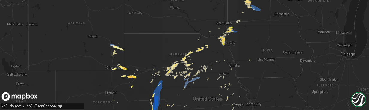
Hail Map in Nebraska on June 2, 2025
The weather event in Nebraska on June 2, 2025 includes Hail, Wind, and Tornado maps. 13 states and 665 cities were impacted and suffered possible damage. The total estimated number of properties impacted is 6,604.
Want more than just the map?
Turn this storm into a full workflow.
- Owner + property data so you know who to knock
- OnDemand branded weather history reports to win the "did we even have hail?" argument
- RoofTrace estimate so reps stop guessing numbers at the door
Bought this map? Upgrade within 7 days and we'll credit the $230. (10-15 min setup call)
Hail
Wind
Tornado
6,604
Estimated number of impacted properties by a 1.00" hail or larger1,745
Estimated number of impacted properties by a 1.75" hail or larger0
Estimated number of impacted properties by a 2.50" hail or largerStorm reports in Nebraska
Nebraska
| Date | Description |
|---|---|
| 06/02/20256:48 PM CDT | Photo of several 1 inch hail stones and report of minor street flooding 638 to 648pm cdt. |
| 06/02/20256:39 PM CDT | Trained spotter reports ping pong ball size hail. |
| 06/02/20256:39 PM CDT | A local report indicates 1.50 inch wind near 3 E Gates |
| 06/02/20256:34 PM CDT | A local report indicates 1.00 inch wind near North Platte |
| 06/02/20256:31 PM CDT | Pws peak wind gust. |
| 06/02/20256:25 PM CDT | A local report indicates 70 MPH wind near Broken Bow |
| 06/01/202511:08 PM CDT | Small area of tree damage. Barn damaged. |
| 06/01/202510:54 PM CDT | Personal weather station reports gust to 64mph. |
| 06/01/202510:52 PM CDT | Personal weather station reports gust to 73mph. |
| 06/01/202510:40 PM CDT | Fire chief reports power poles down in kennesaw. |
| 06/01/202510:35 PM CDT | Personal weather station reports gust to 63mph. |
| 06/01/202510:34 PM CDT | Personal weather station reports gust to 72mph. |
| 06/01/202510:33 PM CDT | Personal weather station gust to 66mph. |
| 06/01/202510:32 PM CDT | Personal weather station gust to 58mph. |
| 06/01/202510:29 PM CDT | Personal weather station gust to 65mph. |
| 06/01/202510:28 PM CDT | Personal weather station gust to 62mph. |
| 06/01/202510:28 PM CDT | Personal weather station gust to 62mpph. |
| 06/01/202510:27 PM CDT | Photo on social media of tree damage in kearney. |
| 06/01/202510:27 PM CDT | Photo on social media of tree damage in kearney. |
| 06/01/202510:27 PM CDT | Photo on social media of tree damage in kearney. |
| 06/01/202510:27 PM CDT | Corrects previous tstm wnd gst report from 3 nne kearney. Personal weather station reports gust to 63mph. |
| 06/01/202510:25 PM CDT | Photo sent in of a car port covering blown on top of a mobile home. |
| 06/01/202510:25 PM CDT | Image sent in of a fallen tree. Hail under 1 inch and shingle damage was additionally reported. |
| 06/01/202510:20 PM CDT | Photo sent in of a large tree snapped in half. |
| 06/01/202510:20 PM CDT | Pictures sent in of a few downed 6 inch estimated tree limbs. |
| 06/01/202510:20 PM CDT | Picture sent in of a large tree limb... Greater than 1 foot in diameter... Down across a car. |
| 06/01/202510:12 PM CDT | Personal weather station gust to 58mph. |
| 06/01/202510:02 PM CDT | Awos reports gust to 61mph. |
| 06/01/202510:00 PM CDT | Personal weather station gust to 63mph. |
| 06/01/20259:56 PM CDT | Personal weather station gust to 64mph. |
| 06/01/20259:54 PM CDT | Personal weather station gust to 63mph. |
| 06/01/20259:40 PM CDT | Personal weather station gust to 64mph. |
| 06/01/20258:40 PM CDT | A local report indicates 58 MPH wind near 1 ESE Imperial |
| 06/01/20258:24 PM CDT | Weather link site parman reports 62 mph wind gust. |
| 06/01/20258:18 PM CDT | Lorens farm awn 64 mph gust. |
| 06/01/20258:16 PM CDT | Awn site ellis reports 58 mph wind gust. |
| 06/01/20258:11 PM CDT | Awn site lorens farm reports 64 mph wind gust. |
| 06/01/20258:10 PM CDT | Tree uprooted and fallen on a house in town. |
| 06/01/20257:16 PM CDT | The public estimated a 6 inch in diameter tree branch down. |
| 06/01/20257:08 PM CDT | Delayed report. Power poles damaged. Time estimated by radar. |
| 06/01/20257:03 PM CDT | In addition to quarter sized hail... 60-70 mph estimated winds blew over the rain gauge and broke some sticks. Rainfall was at least 1 inch. |
All States Impacted by Hail Map on June 2, 2025
Cities Impacted by Hail Map on June 2, 2025
- Goree, TX
- Tampa, FL
- Gibsonton, FL
- Riverview, FL
- Brandon, FL
- Boca Grande, FL
- Seffner, FL
- Dimmitt, TX
- Adrian, TX
- Vega, TX
- Brentford, SD
- Immokalee, FL
- Mellette, SD
- Conde, SD
- Stratford, SD
- Miami, FL
- Opa Locka, FL
- Hollywood, FL
- Ortley, SD
- Hialeah, FL
- Peever, SD
- Grenville, SD
- Summit, SD
- Wilmot, SD
- Aguilar, CO
- Fort Lauderdale, FL
- Walsenburg, CO
- Bovina, TX
- Milbank, SD
- Beardsley, MN
- Ortonville, MN
- Clinton, MN
- Stockholm, SD
- Ochopee, FL
- Miami Gardens, FL
- Browns Valley, MN
- Quemado, NM
- Friona, TX
- Dumont, MN
- Graceville, MN
- Twin Brooks, SD
- Barry, MN
- Pompano Beach, FL
- Appleton, MN
- Chokio, MN
- Key Biscayne, FL
- Hereford, TX
- Boca Raton, FL
- Deerfield Beach, FL
- Morris, MN
- Hancock, MN
- Cyrus, MN
- Alberta, MN
- Holloway, MN
- Donnelly, MN
- Herman, MN
- Barrett, MN
- Norcross, MN
- Elbow Lake, MN
- Ashby, MN
- Evansville, MN
- Danvers, MN
- Delray Beach, FL
- Benson, MN
- Clontarf, MN
- Kensington, MN
- Starbuck, MN
- Hoffman, MN
- Garfield, MN
- Brandon, MN
- Farwell, MN
- Alexandria, MN
- Dalton, MN
- Battle Lake, MN
- Glenwood, MN
- Lowry, MN
- Villard, MN
- Carlos, MN
- Clitherall, MN
- Parkers Prairie, MN
- Miltona, MN
- Vining, MN
- Texico, NM
- Broadview, NM
- Clovis, NM
- Cannon Afb, NM
- Portales, NM
- Nelson, MN
- Osakis, MN
- Murdock, MN
- Brooten, MN
- Sunburg, MN
- Pennock, MN
- Belgrade, MN
- Sauk Centre, MN
- New London, MN
- Henning, MN
- Elrosa, MN
- Melrose, MN
- Deer Creek, MN
- Wadena, MN
- Hewitt, MN
- West Union, MN
- Happy, TX
- Canyon, TX
- Dalhart, TX
- Channing, TX
- Hartley, TX
- Augusta, AR
- Balmorhea, TX
- Laguna, NM
- Tulia, TX
- Silverton, TX
- Amarillo, TX
- Kress, TX
- Montevideo, MN
- Madison, MN
- Albuquerque, NM
- Clewiston, FL
- Bosque Farms, NM
- Maynard, MN
- Watson, MN
- Alcester, SD
- Lubbock, TX
- Idalou, TX
- Petersburg, TX
- Abernathy, TX
- New Deal, TX
- Hale Center, TX
- Wayside, TX
- Claude, TX
- Fritch, TX
- Panhandle, TX
- Stratford, TX
- Groom, TX
- Floydada, TX
- Clara City, MN
- Hudson, SD
- Kerkhoven, MN
- Plainview, TX
- Nazareth, TX
- Clarendon, TX
- Quitaque, TX
- Van Tassell, WY
- Hawarden, IA
- Rock Valley, IA
- Raymond, MN
- Lovington, NM
- Palm City, FL
- Indiantown, FL
- Tokio, TX
- Sioux Center, IA
- Rolla, KS
- Meadow, TX
- Castle Rock, CO
- Guymon, OK
- Franktown, CO
- Stinnett, TX
- White Deer, TX
- Pampa, TX
- Skellytown, TX
- Borger, TX
- Willmar, MN
- Fairview, SD
- Hugoton, KS
- Richfield, KS
- Texhoma, OK
- Keyes, OK
- Boise City, OK
- Lockney, TX
- Slaton, TX
- Ransom Canyon, TX
- Fort Stockton, TX
- Hector, MN
- Sacred Heart, MN
- Big Falls, MN
- Glendo, WY
- Renville, MN
- Cheyenne, WY
- Inwood, IA
- Doon, IA
- Granite Falls, MN
- Spicer, MN
- Prinsburg, MN
- Danube, MN
- Blomkest, MN
- Littlefork, MN
- Gruver, TX
- Spearman, TX
- Lake Lillian, MN
- Estancia, NM
- Broken Bow, NE
- Hardesty, OK
- Belen, NM
- Taylor, NE
- Burwell, NE
- Westbrook, MN
- Alvord, IA
- Mountainair, NM
- Anselmo, NE
- Johnson, KS
- Vermillion, SD
- Rock Rapids, IA
- Atwater, MN
- Wynot, NE
- Mclean, TX
- Perryton, TX
- Miami, TX
- Orr, MN
- Olivia, MN
- Manter, KS
- Grove City, MN
- Bird Island, MN
- Wheatland, WY
- Guernsey, WY
- Hartville, WY
- Newcastle, NE
- Ulysses, KS
- Rushmore, MN
- Kandiyohi, MN
- Cosmos, MN
- Lamberton, MN
- Storden, MN
- Burbank, SD
- Elk Point, SD
- George, IA
- Yoder, WY
- Fort Laramie, WY
- Jay Em, WY
- Orchard, NE
- Hooker, OK
- Moriarty, NM
- Sargent, NE
- Ewing, NE
- Chambers, NE
- Brady, NE
- Maxwell, NE
- Callaway, NE
- Litchfield, MN
- Redwood Falls, MN
- Hull, IA
- Tribune, KS
- Levelland, TX
- Ireton, IA
- Pecos, TX
- Worthington, MN
- Reading, MN
- Kendall, KS
- Lingle, WY
- Crane Lake, MN
- Morton, MN
- Franklin, MN
- Liberal, KS
- Tyrone, OK
- Burns, WY
- Brewster, MN
- Arnold, NE
- Hershey, NE
- Royal, NE
- Brunswick, NE
- Imperial, TX
- Satanta, KS
- Fairfax, MN
- Elbert, CO
- Plainview, NE
- Buffalo Lake, MN
- North Platte, NE
- Hollis, OK
- Merna, NE
- Carpenter, WY
- Clearwater, NE
- Lakin, KS
- Stapleton, NE
- Ropesville, TX
- Boyden, IA
- Orange City, IA
- Torrington, WY
- Kismet, KS
- Plains, KS
- Meade, KS
- Garden City, KS
- Holcomb, KS
- Morgan, MN
- Gould, OK
- Sleepy Eye, MN
- Pine Bluffs, WY
- Hospers, IA
- Sheldon, IA
- Ribera, NM
- Duke, OK
- Wolfforth, TX
- Smyer, TX
- Shallowater, TX
- Ponca, NE
- Lorenzo, TX
- Mobeetie, TX
- Canadian, TX
- Briscoe, TX
- Sheridan Lake, CO
- Mangum, OK
- Beaver, OK
- Vinson, OK
- Deerfield, KS
- Neligh, NE
- Veguita, NM
- Leoti, KS
- Balko, OK
- Lipscomb, TX
- Higgins, TX
- Booker, TX
- Laverne, OK
- Darrouzett, TX
- Follett, TX
- Gothenburg, NE
- Bushnell, NE
- Dixon, NE
- Gate, OK
- Winona, KS
- Jefferson, SD
- New Ulm, MN
- Gibbon, MN
- Winthrop, MN
- Lafayette, MN
- Lake Crystal, MN
- Courtland, MN
- Mankato, MN
- Nicollet, MN
- Saint Peter, MN
- Archer, IA
- Willow, OK
- Briggsdale, CO
- Tahoka, TX
- Weskan, KS
- Sayre, OK
- Fowler, KS
- Granite, OK
- Sharon Springs, KS
- Erick, OK
- Burlington, CO
- Yeso, NM
- Ansley, NE
- Westerville, NE
- Waterbury, NE
- Allen, NE
- Roswell, NM
- Rosston, OK
- Carter, OK
- Wallace, KS
- Edson, KS
- Goodland, KS
- Kanorado, KS
- Dill City, OK
- Sentinel, OK
- Cheyenne, OK
- Jackson, NE
- Ashland, KS
- Oakley, KS
- Oneill, NE
- Brewster, KS
- Emerson, NE
- Hubbard, NE
- Grinnell, KS
- Gove, KS
- Canute, OK
- Socorro, NM
- Hammon, OK
- Willard, NM
- Grant, NE
- New Raymer, CO
- Alamo, NV
- Leedey, OK
- Englewood, KS
- Forgan, OK
- Grainfield, KS
- Reydon, OK
- Sharon, OK
- Lynch, NE
- Fort Sumner, NM
- Wilson, TX
- Grover, CO
- Oconto, NE
- Madrid, NE
- Saint Francis, KS
- Foss, OK
- Mason City, NE
- Elsie, NE
- Wellfleet, NE
- Stoneham, CO
- Clinton, OK
- Venango, NE
- Mutual, OK
- Mooreland, OK
- Comstock, NE
- Park, KS
- Scotland, SD
- Vici, OK
- Arapaho, OK
- Las Vegas, NM
- Encino, NM
- Litchfield, NE
- Bessie, OK
- Corn, OK
- Merino, CO
- Taiban, NM
- Utica, KS
- Quinter, KS
- Waynoka, OK
- Ord, NE
- Ransom, KS
- Adrian, MN
- Chester, OK
- Weatherford, OK
- Imperial, NE
- Sweetwater, OK
- Hurley, SD
- Davis, SD
- Camargo, OK
- Taloga, OK
- Seiling, OK
- Alva, OK
- Hardtner, KS
- Ellis, KS
- Bigelow, MN
- Sterling, CO
- Arcadia, NE
- Loup City, NE
- Benkelman, NE
- Thomas, OK
- Custer City, OK
- Dodson, TX
- Brownell, KS
- Kiowa, KS
- Hazelton, KS
- Burlington, OK
- Fairview, OK
- Atwood, CO
- Elk City, OK
- Butler, OK
- Champion, NE
- Lenora, KS
- Haigler, NE
- Wallace, NE
- Wauneta, NE
- Aline, OK
- McDonald, KS
- Bird City, KS
- Stratton, NE
- Max, NE
- Palisade, NE
- Dodge City, KS
- Minneola, KS
- Wright, KS
- Ensign, KS
- Spearville, KS
- Montezuma, KS
- Ford, KS
- Peetz, CO
- Watonga, OK
- Wray, CO
- Snyder, CO
- Brush, CO
- Lexington, NE
- Cozad, NE
- Carmen, OK
- Dacoma, OK
- Fay, OK
- Dickens, NE
- Arnett, OK
- Cherokee, OK
- Fleming, CO
- Akron, CO
- Farnam, NE
- Eustis, NE
- Wellington, TX
- Moorefield, NE
- Stockville, NE
- Sidney, NE
- Canton, OK
- Miller, NE
- Amorita, OK
- Hayes Center, NE
- Maywood, NE
- Almena, KS
- Long Island, KS
- Curtis, NE
- Stamford, NE
- Eddyville, NE
- Elwood, NE
- Hitchcock, OK
- Okeene, OK
- Helena, OK
- Bertrand, NE
- Hazard, NE
- Loomis, NE
- Grandfalls, TX
- Cordell, OK
- Overton, NE
- Sumner, NE
- Orleans, NE
- Pleasanton, NE
- Beresford, SD
- Gail, TX
- Jet, OK
- Kingfisher, OK
- Crane, TX
- Elm Creek, NE
- Nash, OK
- Holdrege, NE
- Bloomington, NE
- Ames, OK
- Hennessey, OK
- Geary, OK
- Amherst, NE
- Kearney, NE
- Minden, NE
- Riverdale, NE
- Brule, NE
- Oakwood, OK
- Odessa, NE
- Franklin, NE
- Hildreth, NE
- Upland, NE
- Ravenna, NE
- Waukomis, OK
- Riverton, NE
- Cleo Springs, OK
- Longdale, OK
- Southard, OK
- Kenesaw, NE
- Shelton, NE
- Gibbon, NE
- Justiceburg, TX
- Odessa, TX
- Douglas, OK
- Greenfield, OK
- McCamey, TX
- Wood River, NE
- Midkiff, TX
- Doniphan, NE
- Enochs, TX
- Colony, OK
- Fairmont, OK
- Grand Island, NE
- Omega, OK
- Morton, TX
- Sudan, TX
- Cairo, NE
- Alda, NE
- Saint Paul, NE
- Palmer, NE
- Sutton, NE
- Midland, TX
- Edgar, NE
- Chapman, NE
- Marquette, NE
- Aurora, NE
- Saint Libory, NE
- Central City, NE
- Leonardville, KS
- Riley, KS
- Palmer, KS
- Linn, KS
- Green, KS
- Archer, NE
- Hydro, OK
- Hinton, OK
- Saint George, KS
- Westmoreland, KS
- Barnes, KS
- Loyal, OK
- Western, NE
- Dover, OK
- Odell, NE
- Clatonia, NE
- Garden City, TX
- Dorchester, NE
- Crete, NE
- Wilber, NE
- Lamesa, TX
- Ackerly, TX
- Stromsburg, NE
- Clarks, NE
- Beatrice, NE
- Greenleaf, KS
- Steele City, NE
- Brownfield, TX
- Diller, NE
- Wymore, NE
- Osceola, NE
- Silver Creek, NE
- Benedict, NE
- Seminole, TX
- Hallam, NE
- Cortland, NE
- Beattie, KS
- Blue Springs, NE
- Odonnell, TX
- Kermit, TX
- Burchard, NE
- Sprague, NE
- Roca, NE
- Martell, NE
- Post, TX
- Paxico, KS
- Fluvanna, TX
- Corning, KS
- Schuyler, NE
- Columbus, NE
- Steinauer, NE
- Tecumseh, NE
- Lewiston, NE
- Eskridge, KS
- Harveyville, KS
- Goldsmith, TX
- Maple Hill, KS
- Pawnee City, NE
- Goff, KS
- Oxford, NE
- Wilcox, NE
- Heartwell, NE
- Atlanta, NE
- Roseland, NE
- Holstein, NE
- Alma, NE
- Juniata, NE
- Axtell, NE
- Funk, NE
- Topeka, KS
- Gardendale, TX
- North Bend, NE
- Andrews, TX
- Ames, NE
- Hooper, NE
- Stanton, TX
- Muscotah, KS
- Louisville, NE
- Rulo, NE
- Crawford, OK
- Durham, OK
- Springfield, NE
- Buffalo, OK
- Medicine Lodge, KS
- Wilmore, KS
- Isabel, KS
- Protection, KS
- Nashville, KS
- Coldwater, KS
- Big Lake, TX
- Zenda, KS
- Spivey, KS
- Kingman, KS
- Exira, IA
- Brayton, IA
- Dryden, TX
- Murdock, KS
- Milton, KS
- Barnhart, TX
- Clearwater, KS
- Viola, KS
- Ozona, TX
- Conway Springs, KS
- Whitewater, KS
- Potwin, KS
- Comstock, TX
- Madison, KS


